
Vardar Banovina
| Vardar Banovina Вардарска бановина Vardarska banovina | |||||||||||||
|---|---|---|---|---|---|---|---|---|---|---|---|---|---|
| Banovina of Yugoslavia | |||||||||||||
| 1929–1941 | |||||||||||||
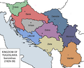
 Vardar Banovina (red) within the Kingdom of Yugoslavia (light yellow) | |||||||||||||
| Capital | Skopje | ||||||||||||
| Area | |||||||||||||
• 1931 | 36,672 km2 (14,159 sq mi) | ||||||||||||
| Population | |||||||||||||
• 1921 | 1,323,546 | ||||||||||||
• 1931 | 1,574,243 | ||||||||||||
| History | |||||||||||||
• Established | 1929 | ||||||||||||
• Disestablished | 1941 | ||||||||||||
| |||||||||||||
| Today part of | Kosovo North Macedonia Serbia | ||||||||||||
| History of North Macedonia |
|---|
 |
| Chronological |
|
| Topical |
| Related |
| Lists and outlines |
|
|
The Vardar Banovina, or Vardar Banate (
banate) of the Kingdom of Yugoslavia
between 1929 and 1941.
History
It was located in the southernmost part of the country, encompassing the whole of today's
Albania under Italy. Following World War II, the southern portion of the region became Socialist Republic of Macedonia while the northern portions were made a part of the Socialist Republic of Serbia, both within the Socialist Federal Republic of Yugoslavia
.
Bans of Vardar Banovina
- Živojin Lazić (1929–1932)
- Dobrica Matković (1932–1933)
- Dragoslav Đorđević (1933–1935)
- Ranko Trifunović (1935–1936)
- Dušan Filipović (1936)
- Dragan Paunović (1936–1937)
- Marko Novaković (1937–1939)
- Vladimir Hajduk-Veljković (1939)
- Aleksandar Cvetković (1939)
- Aleksandar Andrejević (1939–1940)
- Žika Rafajlović (1940–1941)
Cities and towns
- Skopje (capital)
- Berovo
- Bitola
- Bosilegrad
- Delčevo
- Debar
- Dragaš
- Gevgelija
- Gjilan
- Gostivar
- Makedonski Brod
- Kaçanik
- Kavadarci
- Kičevo
- Kočani
- Kratovo
- Kriva Palanka
- Kruševo
- Kumanovo
- Lebane
- Leskovac
- Negotino
- Ohrid
- Preševo
- Prilep
- Pristina
- Prizren
- Radoviš
- Resen
- Rostuša
- Strumica
- Surdulica
- Suva Reka
- Sveti Nikola
- Štip
- Tetovo
- Ferizaj
- Valandovo
- Veles
- Vladičin Han
- Vranje
-
 Map of Yugoslav banovinas in 1929 (The Vardar Banovina is #9)
 -
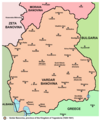 Map of Vardar Banovina
 -
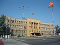 Assembly of the Republic of North Macedonia


See also
References
- ^ Published in the: Central Press Bureau of the Ministerial Council, Belgrade 1930
- ISBN 9781850656630.
- ISBN 9781476610191.
- .
External links
Wikimedia Commons has media related to Vardar Banovina.
Banovinas of the Kingdom of Yugoslavia (1929–1941) | ||||||||||
|---|---|---|---|---|---|---|---|---|---|---|
| 1929–1941 |
| .svg) | ||||||||
| Proposed |
| |||||||||
42°00′N 21°25′E / 42.000°N 21.417°E
| International | |
|---|---|
| National | |