Wieprz
Appearance
| Wieprz | |
|---|---|
 Wieprz in Roztocze National Park | |
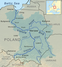
 Wieprz River in the Vistula watershed | |
| Native name | Вепр (Ukrainian) |
| Location | |
| Country | Poland |
| Voivodeship | Mazovian, Lublin |
| Physical characteristics | |
| Source | |
| • location | Wieprzów Tarnawacki, Lublin Voivodeship, Poland |
| • coordinates | 50°30′01.7″N 23°26′14.4″E / 50.500472°N 23.437333°E |
| • elevation | 274 m |
| Mouth | |
• location | Dęblin, Lublin Voivodeship, Poland |
• coordinates | 51°32′49″N 21°50′4″E / 51.54694°N 21.83444°E |
• elevation | 112 m |
| Length | 349 km (217 mi) |
| Basin size | 10,497 km2 (4,053 sq mi) |
| Discharge | |
| • average | 35.9 m3/s (1,270 cu ft/s) |
| Basin features | |
| Progression | Vistula→ Baltic Sea |
The Wieprz (Polish: [ˈvjɛpʂ] , lit. '"Boar"'; Ukrainian: Вепр, romanized: Vepr) is a river in central-eastern Poland, and a tributary of the Vistula. It is the country's ninth longest river, with a total length of 349 km and a catchment area of 10,497 km2, all within Poland.[1] Its course near the town of Łęczna includes the protected area known as Wieprz Landscape Park.
The river has its source in Lake Wieprz, in
European otters and Eurasian beavers
.
During the
Battle of Tomaszow Lubelski
took place by the Wieprz.
Towns on the Wieprz
See also
References
- Statistics Poland, p. 85-86
- ^ Bojakowska, Izabela; Gliwicz, Tomasz; Kozłowska, Olimpia; Szyborska-Kaszycka, Joanna (2010). "Charakterystyka geochemiczna wód rzeki Wieprz" (PDF). Górnictwo i Geologia (in Polish). 5 (4): 51–62.

