
Birgunj
Birganj
वीरगञ्ज Gateway of Nepal | |
|---|---|
UTC+5:45 (NST) | |
| Postal code | 44300, 44301 |
| Area code | 51 |
| Website | birgunjmun |
 | |
Birganj (
Birganj was one of the first three municipalities formed during the rule of Prime Minister
Etymology
Birganj was established as a conglomerate of several villages in and around Gahawa Mai Temple. Gahawa Mai Temple remains the epicenter of the town. The settlement was named after Rana Prime Minister
History
Ancient
Before the establishment of Birganj, the main center of Parsa district was Alau (near Dryport), Nepal. In July 1959 From Sugauli King Rajendra Bikram Shah has a history of setting up a military camp in Alau of Parsa district.[citation needed]
The ancient name of Birganj was Gahawa but the 11th Rana Prime Minister of Nepal
After the death of Bir Shamsher Jang Bahadur Rana,
Chandra Shamsher also wanted to displace Birganj Bazar, which his brother had established. He wanted to remove the Birganj bazaar from there and set it in Rautahat. According to the move to displace the market, In 1959, it raided the main market from Raxaul to Birganj and extended the rail line service to Amlekhganj. From the link, the train used to run around the houses, exploding and terrorizing the residents. Later, the rail link was moved to the east of the market (outside the market). The Raxaul city in India, which is currently connected to Birganj as the main gateway to Nepal, was not established. At that time Indian trains operated only till Sugauli.[4]
Modern
On 18 May 2006, the parliament of Nepal declared that the country would become a secular state, prompting the
Geography
Topography, Geology and Soils
Birganj is located in the Terai plain which is the northern part of the Indo-Gangetic plain. Birganj metropolitan city has an elongated shape. The variation in altitude is in the range of 78 m to 95 m when moving from south to north of Birgunj. Although the range of altitude variation is small, but there is a high micro-topographical variation. The city lies about 90 m above sea level. Quaternary sediments are mainly found in the area. Soil is very fertile that consists the mixture of clay, silt and sand.[6]
Climate
The climatic condition is sub-tropical monsoon with a very hot and humid summer. The mean annual temperature ranges from 23.8 to 24.5 °C (74.8 to 76.1 °F). The annual rainfall ranges from about 1,300 to 2,800 mm (51 to 110 in) with an average of 1,800 mm (71 in). Majority of the precipitation occurs during June, July, August and September.[7]
| Climate data for Birgunj (Simara Airport), (1991–2020 normals, extremes 1971–2017) | |||||||||||||
|---|---|---|---|---|---|---|---|---|---|---|---|---|---|
| Month | Jan | Feb | Mar | Apr | May | Jun | Jul | Aug | Sep | Oct | Nov | Dec | Year |
| Record high °C (°F) | 29.6 (85.3) |
34.2 (93.6) |
39.2 (102.6) |
41.7 (107.1) |
42.2 (108.0) |
42.8 (109.0) |
38.8 (101.8) |
39.8 (103.6) |
37.0 (98.6) |
36.2 (97.2) |
34.2 (93.6) |
30.2 (86.4) |
42.8 (109.0) |
| Mean daily maximum °C (°F) | 21.1 (70.0) |
25.8 (78.4) |
31.0 (87.8) |
35.1 (95.2) |
35.2 (95.4) |
34.5 (94.1) |
33.0 (91.4) |
33.1 (91.6) |
32.8 (91.0) |
31.9 (89.4) |
29.0 (84.2) |
24.1 (75.4) |
30.6 (87.1) |
| Daily mean °C (°F) | 14.4 (57.9) |
17.9 (64.2) |
22.4 (72.3) |
27.2 (81.0) |
29.2 (84.6) |
29.9 (85.8) |
29.4 (84.9) |
29.4 (84.9) |
28.6 (83.5) |
26.0 (78.8) |
21.5 (70.7) |
16.8 (62.2) |
24.4 (75.9) |
| Mean daily minimum °C (°F) | 7.7 (45.9) |
9.9 (49.8) |
13.8 (56.8) |
19.2 (66.6) |
23.2 (73.8) |
25.3 (77.5) |
25.7 (78.3) |
25.6 (78.1) |
24.4 (75.9) |
20.1 (68.2) |
13.9 (57.0) |
9.5 (49.1) |
18.2 (64.8) |
| Record low °C (°F) | 1.0 (33.8) |
1.6 (34.9) |
5.2 (41.4) |
9.0 (48.2) |
14.0 (57.2) |
19.0 (66.2) |
20.6 (69.1) |
20.8 (69.4) |
19.0 (66.2) |
10.6 (51.1) |
6.0 (42.8) |
3.0 (37.4) |
1.0 (33.8) |
| Average precipitation mm (inches) | 14.1 (0.56) |
15.7 (0.62) |
17.3 (0.68) |
41.8 (1.65) |
135.5 (5.33) |
272.1 (10.71) |
549.5 (21.63) |
422.0 (16.61) |
254.8 (10.03) |
68.0 (2.68) |
4.5 (0.18) |
7.7 (0.30) |
1,803 (70.98) |
| Average precipitation days (≥ 1.0 mm) | 1.7 | 1.8 | 2.0 | 4.1 | 8.9 | 12.8 | 18.7 | 15.5 | 11.8 | 3.4 | 0.5 | 0.7 | 81.9 |
| Source 1: Department of Hydrology and Meteorology[8][9] | |||||||||||||
| Source 2: World Meteorological Organization[10] | |||||||||||||
Surface and Ground Water
Sirsiya in the west and Singaha in the east are the two major rivers in Birganj. Both rivers flow from north to south. During monsoon, these rivers are flooded and river bank cutting at the bends is common. The water level is very low in these rivers during winter. The depth of groundwater table is approximately between 9–15 m (30–49 ft) deep with 1–2 m (3 ft 3 in – 6 ft 7 in) fluctuation during wet and dry season.[11]
Demographics
According to the 2021 Census, Birganj had a population of 268,273.[12] It is the second biggest city in Terai and the fifth biggest city in Nepal after Kathmandu, Pokhara, Bharatpur, and Lalitpur. It serves as the headquarters of the Parsa District.
At the time of the 2011 Nepal census, Birganj Metropolitan City had a population of 244,086. Of these, 78.6% spoke Bhojpuri, 6.5% Nepali, 5.5% Maithili, 3.1% Urdu, 1.9% Rajasthani, 1.5% Newar, 0.7% Tharu, 0.6% Hindi, 0.4% Rai, 0.1% Bengali, 0.1% Magar, 0.1% Punjabi, 0.1% Tamang, 0.1% Uranw/Urau, and 0.1% other parties as their first language.[13]
In terms of ethnicity/caste, 18.1% were
In terms of religion, 81.1% were Hindu, 17.9% Muslim, 0.4% Buddhist, 0.1% Christian, 0.1% Kirati, 0.1% Sikh and 0.2% others.[15]
In terms of literacy, 66.5% could read and write, 2.4% could only read and 31.0% could neither read nor write.[16]
Economy
Birganj is the Industrial and Commercial Capital of Nepal. Birganj Chamber of Commerce & Industries is the leading and the oldest Chamber of Commerce & Industries in Nepal.
In 1964 when Birganj Sugar Factory Ltd. was established by the Government of Nepal in collaboration with the Soviet Union (at present, Russia) with initial crushing capacity of 1,000 metric tons which later increased to 1,500 metric tons (Rajak, 2006). This was the first sugar mill established in the public sector. Later on, this mill was liquidated due to heavy losses.
Birganj is a major business centre of Nepal, especially for trade with India. Almost all trade with India occurs through this route. The Indian border town of
Birganj Customs holds a major contribution in terms of revenue earnings in the nation. On 16 July 2004
The India-Nepal oil pipeline construction that began on 9 March 2018, saw its completion up to 13 km (8.1 mi). The 69-kilometre (43 mi) Amlekhgunj-Raxaul oil pipeline connecting the two countries has been laid along the Pathlaiya-Simara-Jitpur, Parwanipur and Birganj bypass roadway. According to the reports, major part of the pipeline alignment is covered in the Birgunj-Pathlaiya commercial highway.[18]
Tourism
Birganj is main entry to Nepal. So, the city is widely visited by the Indians. There are good three-star hotels in the main centre of the city. These hotels operate some mini casinos as well.

During Chhath festival, Ghadiarwa Pokhari is visited by numerous people from different parts of the country. Vishwa Buddha Vihar is another religious place which is located in the out-skirts of the city. Vishwa is actually shaped like a stupa and has engravings of Buddha facing the cardinal directions of the universe. This place has a tranquil ambience and it attracts those tourists who want to flee the bustling life of the city. The term vishwa is derived from the word vicchu-wa, which is translated as a resting place for Bikshu(s) or Buddhist monks and means a resting place. In the ancient times, the pilgrims stopped at Birganj in the midst of their journey between Lumbini and Bodh Gaya (India). The mound is protected by a boundary wall, and future excavations may well tell us about the history of not just Birganj but also its importance to Buddhism 2,500 years ago.
Transport
Birganj was built as the closest Nepalese city connecting the capital Kathmandu with India. Birganj railway station was connected by the
Rail
Trains run to major cities of India from Raxaul station (in India, adjacent to Birganj) and Sugauli station (17 miles from Raxaul) including the
Air
Birganj is served by Simara Airport, which lies 9 miles north of the city. Regular flights operate to Kathmandu & Pokhara, and . The second International Airport of Nepal is under construction at Nijgadh (22 miles from Birganj). There are plans to connect the new airport, Birganj and Kathmandu via a "Fast track" expressway after its completion. This is expected to reduce travel times between the capital and the commercial capital, Birganj.
Buses
There are regular bus services to all major cities and towns in Nepal including Kathmandu, Pokhara, Patan,

Tanga
Horse driven carts locally called Tanga have historically been the mode of transport for the Madheshi people. Today it survives as a popular transportation vehicle between Birganj and its sister city Raxaul.
Cargo
The 6 km (3.7 mi) railway track from Raxaul to Birganj was converted to
Goods are transported to and from India via Birganj dry port, which is the key terminal of surface cargo delivery to Nepal. This cargo point on the south connects the heart of the country, Kathmandu, via another key industrial city,
India and Nepal have an open border with no restrictions on the movement of their citizens. There is a customs checkpoint for the movement of goods between the two countries.

Sports

The city has its own stadium, Narayani Stadium which is Nepal's second largest stadium after Dasarath Rangasala built on 1981. The stadium has capacity of 15,000 seats.Its the home ground of Birganj United FC.The team plays in Nepal Super League, top tier football league.
A national level
Education
Birganj has a history in education. Education was started in town with the establishment of Trijuddha School by Mahavir Prasad and Raghubir Ram during the regime of Juddha Shumsher Jung Bahadur Rana which was among the first three schools to be established in Nepal. Currently, Trijuddha School is the second oldest school in Nepal. It serves classes in both English and Nepali Medium and also conducts diplomas for civil engineering.
Thakuram Multiple Campus, located in the city was the first campus to be established outside Kathmandu Valley as well as in the Narayani zone. This city has made rapid development in the field of education by the establishment of many schools and colleges. Notable institutions include:
Universities
- Madhesh University (Nepali: मधेश विश्वविद्यालय) (MU), established on Bhadra 23, 2079 B.S.[21]
Media
Birganj has many FM Community radio stations including Narayani FM 103.8Mhz, Terai FM, Radio Birgunj, Bhojpuriya FM, Indreni FM, Radio Bindas, Birgunj Musical FM, City FM, Aawaz FM, Public FM etc. It has also different television stations: My Television, TV Birgunj and Birgunj Television (BTV). Many local newspapers like Prateek, Loktimes Daily, Kripa, Bhojpuri Time, Birgunjsanjal, Jana Aawaz etc. are published.
Some popular online news site like Yatra daily, Nepal Post Daily, Aapan Birgunj, etc. are from Birganj. TEDxBirgunj was successfully held on 17 December,[22] that was the first ever TED event conducted in Terai region of Nepal.
Health

Narayani Hospital is one of the oldest government hospital of Nepal. It is the central hospital of government of Nepal. National Medical College[23] under TU and Kedia Dental College[24] also under TU are two major institutions providing health facilities. There are many other big and small hospitals, and international standard diagnostic centres throughout the city such as Asharam Hospital, Gandak hospital, Advance Medicare Hospital, Kedia eye hospital, Bhawani Hospital, Mangalam Diagnostic Centre, Vision Diagnostic Private Limited, Nepal Mediciti Vayodha Hospital etc. The area extending from Chhapakaiya ward No. 3 up to Gandak is full of private nursing homes and clinics. Mostly the people of Nepal from Parsa, Bara, Rautahat, Sarlahi and other districts along with the people from Raxaul and different districts of India come here for medical check ups & treatments.
Culture
Cuisine
The cuisine of Birganj has influence of both Nepali and Indian culture. Dal, bhat, roti, vegetable curry, and achar (pickle) are the most widely consumed food items. Tibetan cuisine such as momo and chowmein are also popular among the youths and the elderly. A place named Adarsh Nagar has established its name as the center for street food where food vendors sell varieties of street food during evening time. Food such as Pav Bhaji (bread and vegetable curry) and Chaat (snack made with potato as the main ingredient) are relatively popular.
Notable people
- Ranu Devi Adhikari — Nepalese singer
- Usha Khadgi — winner of Miss Nepal 2000
- Anju Kumari — politician
- Ruby Rana — winner of Miss Nepal 1994
- Samragyee RL Shah — actress
- Aarif Sheikh — cricketer
- Aasif Sheikh – cricketer
- Prakash Shrestha — singer
- Brijesh Kumar Mallik — Vishwa Hindu Parishad Nepal
Places of interest
Gallery
-
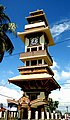 Clock tower Birgunj
 -
 Shankaracharya gate in Birgunj
 -
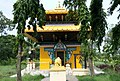
 Bindhyabasini Temple, Birgunj
 -
 Shiva Temple located inside the Birgunj Sugar Mill compound


See also
References
- ^ "Know Birgunj Mayor Rajesh Man Singh in 5 points". No. 24 May 2022. Online Khabar. Online Khabar. 24 May 2022. Archived from the original on 24 May 2022. Retrieved 25 May 2022.
- ^ "Preliminary Report of National Population 2021". Central Bureau Statistics, Nepal. 27 January 2022. Archived from the original on 27 January 2022. Retrieved 9 March 2022.
- ^ "ABOUT BIRGANJ". www.cgibirgunj.org. Archived from the original on 12 July 2017. Retrieved 4 July 2017.
- ^ "How birganj formed?". Birganj Municipality Nepal. Nepal Government. Archived from the original on 24 March 2020. Retrieved 6 April 2020.
- ^ Sangraula, Bikash (30 May 2006). "Nepal faces Hindu backlash over declaration as secular state". The Christian Science Monitor. Archived from the original on 8 September 2020. Retrieved 8 September 2020.
- ^ "Birganj Initial Environmental Assessment" (PDF). Archived (PDF) from the original on 26 March 2020. Retrieved 26 March 2020.
- ^ "Department of Hydrology and Meteorology". Archived from the original on 27 October 2021. Retrieved 10 November 2021.
- ^ "PRECIPITATION NORMAL (MM) (1991-2020)" (PDF). Department of Hydrology and Meteorology. Archived from the original (PDF) on 14 October 2023. Retrieved 14 October 2023.
- ^ "Annual Extreme Temperatures" (PDF). Department of Hydrology and Meteorology. Archived from the original (PDF) on 14 October 2023. Retrieved 15 October 2023.
- ^ "World Meteorological Organization Climate Normals for 1991–2020". World Meteorological Organization. Archived from the original on 16 October 2023. Retrieved 14 October 2023.
- ^ Department of Hydrology and Meteorology, Climatological Records (various volumes and years)
- ^ "Nepal: Municipal Division (Districts and Local Units) – Population Statistics, Charts and Map". www.citypopulation.de. Archived from the original on 30 August 2023. Retrieved 16 October 2023.
- ^ NepalMap Language
- ^ NepalMap Caste
- ^ NepalMap Religion
- ^ NepalMap Literacy
- ^ CPS, NEPAL 2013, Annual UN Report Bureau.
- ^ "India, Nepal open South Asia's first cross-border oil pipeline". www.aljazeera.com. alzajeera. Archived from the original on 8 April 2020. Retrieved 4 April 2020.
- ^ Park, Parsa National Park. "Parsa National Park". Parsa National Park. Government of Nepal. Archived from the original on 19 July 2020. Retrieved 10 November 2021.
- ^ "Transport in Nepal". nepal.saarctourism.org. Archived from the original on 29 December 2008. Retrieved 20 December 2008.
- ^ https://madheshuniversity.edu.np
- ^ "TEDxBirgunj". Facebook. Archived from the original on 23 November 2019. Retrieved 25 November 2016.
- ^ "National Medical College Birgunj". Archived from the original on 16 August 2021. Retrieved 10 November 2021.
- ^ "MBA Dissertation Writing Ideas and Getting Good Ones | mbkediadentalcollege.com". Archived from the original on 25 February 2021. Retrieved 10 November 2021.
External links
Headquarter: Birgunj | ||
| Metropolitan City |  | |
| Municipalities | ||
| Rural municipalities |
| |