
Drobeta-Turnu Severin
Drobeta-Turnu Severin | |
|---|---|
The Water Castle | |
 Location within Mehedinți County | |
 Drobeta-Turnu Severin Location in Romania | |
| Coordinates: 44°38′N 22°39′E / 44.633°N 22.650°E | |
| Country | Romania |
| County | Mehedinți |
| Government | |
| • Mayor (2020–2024) | Marius Screciu[1] (PSD) |
| Area | 55 km2 (21 sq mi) |
| Elevation | 65 m (213 ft) |
| Population (2021-12-01)[2] | 79,865 |
| • Density | 1,500/km2 (3,800/sq mi) |
| Time zone | EET/EEST (UTC+2/+3) |
| Postal code | 220004–220256 |
| Area code | (+40) 02 52 |
| Vehicle reg. | MH |
| Website | www |

Drobeta-Turnu Severin (Romanian pronunciation: [droˈbeta ˈturnu seveˈrin] ⓘ), colloquially Severin, is a city in Mehedinți County, Oltenia, Romania, on the northern bank of the Danube, close to the Iron Gates. "Drobeta" is the name of the ancient Dacian and Roman towns at the site, and the modern town of Turnu Severin received the additional name of Drobeta during Nicolae Ceaușescu's national-communist dictatorship as part of his myth-making efforts.[3]
Etymology
Drobeta was originally a Dacian town.[4] The Roman fort built by Emperor Trajan at the site preserved the Dacian name.[4] (see "History" section). According to Hamp and Hyllested, Drobeta reflects a roman misinterpretation of *Druwā-tā (the wooden place) with a postposed article, reflecting a proto-Albanian syntax for wood druwa-tai.[5]
"Severin" was originally linked by historians with the Roman Emperor
]Turnu ("Tower") refers to a tower on the north bank of the Danube built by the Byzantines. Thus, the name of the city would mean "Northern Tower".
History

.svg)


Dacian and Roman Eras
Drobeta was first a Dacian town mentioned by Greek geographer Ptolemy of Alexandria (2nd century AD).[4]
Drobeta grew as a strategic point at the crossing of water and land routes which led to the north and south of the Danube. It became the third urban centre in Dacia after Sarmizegetusa and Apullum. During the reign of Emperor Hadrian (AD 117–138), the settlement was declared a municipium in 121. At this point the population had reached 14,000. In 193 during the reign of Septimius Severus (193–211), the city was raised to the rank of a colony which gave its residents equal rights with citizens of Rome. As a colony, Drobeta was a thriving city with temples, a basilica, a theatre, a forum, a port and guilds of craftsmen. In the middle of the 3rd century, Drobeta covered an area of 60 hectares and had a population of almost 40,000 inhabitants.[citation needed]
After the retreat of the Roman administration from Dacia in the 4th century, the city was preserved under Roman occupation as a bridgehead on the north bank of the Danube until the 6th century. Destroyed by Huns in the 5th century, it was rebuilt by Justinian I (527-565).
Sights
On the bank of the Danube are the remains of the celebrated Trajan's Bridge, the longest in the Empire.[8] Here the Danube is about 1,200 m (3,900 ft) wide.
The bridgehead fort has been extensively excavated and is visible today.
Also visible are the extensive remains of the large Roman thermal baths and amphitheatre.
-

-

-
 Baths
Baths -
 Roman Amphitheatre


Middle Ages
The fortress of Severin was built by the
When the
In 1247, the
Severin Fortress was the most important strategic redoubt on the Danube. Its conquest meant to gain an important bridgehead in the region.
Romanian
After the fall of
In 1936, Prof. Dr. Al. Bărăcilă executed excavations at the fortress, where he managed to reconstruct the layout of the castle and recovered rich archaeological materials (rails, iron, copper, stone cannonballs, pipe of a bronze cannon etc.). The fortress was rectangular shaped with two walls made of unprocessed river stones, glued with mortar. In the center of the castle there was a chapel, surrounded by graves, built in part with materials taken from Drobeta Castrum. Also in the fortress was an oven-hearth serving a weapons workshop. Inside the interior, to the north, was a tower with three floors used for defense; to the east a second tower, thicker, at the angle of the wall. The entrance to the castle was through a gate dome and the fortress was surrounded by a deep moat.
Modern times


,_Turnu_Severin.JPG)
After gaining freedom from Ottoman control as a consequence of the Treaty of Adrianople in 1829, it was decided to rebuild the present city. A rigorous program started in 1836. It was followed, in 1858, by the construction of the harbor. By 1900 the national road, rail, the Carol and Elisabeta boulevards, Navigația Fluvială Românească (River Navigation of Romania), the railway workshops, the shipyard (which in 1914 was the largest in the country), the Roman Hall, the Municipal Palace, three churches and two hospitals were built. In 1883, on May 15, Theodor Costescu established Traian High School, which in the next century would become a modern school of national prestige. The building of industrial factories spurred the development of the city. In 1841, Severin became the capital of the county and in 1851 became a city. As a major port on the Danube, the freedom of trade facilitated the entry of goods by boat from Vienna and the exchange of material necessary for economic development. Severin experienced a steady economic, urban and social growth until 1972, when it received the name of Drobeta-Turnu Severin.
In 1914, the Water Castle (Castelul de Apă) was opened. Considered an emblematic monument to the people of Severin, it gives identity to the city by being built in one of the major traffic roundabouts of the city.
The central neighborhoods were spared from the countrywide campaign of demolitions unleashed by the Ceauşescu regime, allowing the historic architecture of the city to survive. In 1968, Turnu Severin became the capital of the county, concurrently becoming a city ("municipiu"). In 1972, the name of the ancient Drobeta was added to the city's name, and it became Drobeta-Turnu Severin.
Population (1859–2021)
|
|
| ||||||||||||||||||||||||||||||||||||||||||||||||
| Source: Census data, 1930–1948.[10] | ||||||||||||||||||||||||||||||||||||||||||||||||||
Climate
The region's climate gives Severin warm summers and mild winters, meaning the city is home to magnolia trees, Caucasian nut trees, and ginkgo biloba as well as the almond trees, figs, lilacs, lindens, and chestnut trees more common throughout Europe.
| Climate data for Drobeta-Turnu Severin (1991–2020) | |||||||||||||
|---|---|---|---|---|---|---|---|---|---|---|---|---|---|
| Month | Jan | Feb | Mar | Apr | May | Jun | Jul | Aug | Sep | Oct | Nov | Dec | Year |
| Record high °C (°F) | 19.6 (67.3) |
23.3 (73.9) |
25.9 (78.6) |
32.0 (89.6) |
35.0 (95.0) |
39.1 (102.4) |
42.6 (108.7) |
41.3 (106.3) |
37.1 (98.8) |
32.1 (89.8) |
25.4 (77.7) |
18.0 (64.4) |
42.6 (108.7) |
| Mean daily maximum °C (°F) | 4.7 (40.5) |
7.5 (45.5) |
13.2 (55.8) |
19.2 (66.6) |
24.3 (75.7) |
28.5 (83.3) |
31.1 (88.0) |
31.2 (88.2) |
25.3 (77.5) |
18.4 (65.1) |
11.0 (51.8) |
5.4 (41.7) |
18.3 (64.9) |
| Daily mean °C (°F) | 0.6 (33.1) |
2.5 (36.5) |
7.1 (44.8) |
12.7 (54.9) |
17.9 (64.2) |
22.1 (71.8) |
24.2 (75.6) |
24 (75) |
18.5 (65.3) |
12.5 (54.5) |
6.7 (44.1) |
1.7 (35.1) |
12.5 (54.5) |
| Mean daily minimum °C (°F) | −2.6 (27.3) |
−1.2 (29.8) |
2.5 (36.5) |
7.3 (45.1) |
12.1 (53.8) |
15.8 (60.4) |
17.6 (63.7) |
17.7 (63.9) |
13.4 (56.1) |
8.3 (46.9) |
3.6 (38.5) |
−1.3 (29.7) |
7.8 (46.0) |
| Record low °C (°F) | −22.2 (−8.0) |
−14.4 (6.1) |
−3.0 (26.6) |
2.4 (36.3) |
6.4 (43.5) |
9.0 (48.2) |
8.6 (47.5) |
1.6 (34.9) |
−3.8 (25.2) |
−14.4 (6.1) |
−16.8 (1.8) |
−18.2 (−0.8) |
−22.2 (−8.0) |
| Average precipitation mm (inches) | 46.2 (1.82) |
42.7 (1.68) |
42.3 (1.67) |
57.1 (2.25) |
69.0 (2.72) |
66.6 (2.62) |
66.1 (2.60) |
41.1 (1.62) |
55.0 (2.17) |
55.4 (2.18) |
54.4 (2.14) |
64.0 (2.52) |
659.9 (25.98) |
| Average precipitation days (≥ 1.0 mm) | 7.3 | 6.3 | 6.4 | 7.4 | 8.0 | 7.4 | 6.0 | 4.5 | 5.8 | 6.0 | 6.9 | 7.5 | 79.5 |
| Mean monthly sunshine hours | 90.4 | 115.1 | 172.5 | 210.2 | 257.9 | 290.2 | 322.0 | 301.9 | 220.0 | 156.0 | 88.9 | 79.5 | 2,304.6 |
| Source: NOAA[11] | |||||||||||||
Notable natives
Gallery
-
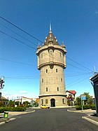 The Water Castle after rehabilitation
 -
 Radu Negru Hall as of 2014
 -
 Iron Gates Region Museum behind Roman ruins
 -
 Roman thermes in Drobeta
 -
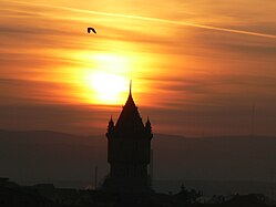 The Water Castle at sunset
 -
 Resurrection Episcopal Cathedral
 -
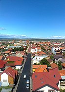 Overview of the city from top of the Water Castle
 -
 1933 stamp


See also
References
- ^ "Results of the 2020 local elections". Central Electoral Bureau. Retrieved 6 June 2021.
- ^ "Populaţia rezidentă după grupa de vârstă, pe județe și municipii, orașe, comune, la 1 decembrie 2021" (XLS). National Institute of Statistics.
- ISBN 9781571816412. Retrieved 14 October 2021.
- ^ a b c Drobeta–Turnu Severin at britannica.com, accessed 2021-10-14.
- ISBN 978-1-108-75866-6
- ^ I. A. Candrea, Elemente de toponimie cu privire specială la toponimia Olteniei, 1932-1933, Facultatea de litere și Filosofie din București, p. 24
- ^ a b Televiziunea online Drobeta Turnu Severin Archived May 27, 2010, at the Wayback Machine. Drobetaturnuseverin.net. Retrieved on 2013-08-20.
- ^ a b One or more of the preceding sentences incorporates text from a publication now in the public domain: Chisholm, Hugh, ed. (1911). "Turnu Severin". Encyclopædia Britannica. Vol. 27 (11th ed.). Cambridge University Press. p. 481.
- ^ Nicolae Iorga, Istoria Bisericii Românești și a vieții religioase a Românilor, vol. I-iu, Vălenii de Munte 1908, 16.
- ^ Populatia RPR la 25 ianuarie 1948, p. 14
- ^ "World Meteorological Organization Climate Normals for 1991-2020 — Drobeta-Turnu Severin". National Oceanic and Atmospheric Administration. Retrieved January 11, 2024.
External links

County seats of Romania (alphabetical order by county) | ||
|---|---|---|
| ||
| Countries |  | |
|---|---|---|
| Cities | ||
| Tributaries | ||
| Canals | ||
| See also | ||
| International | |
|---|---|
| National | |
| Other | |