
Jifna
Jifna | |
|---|---|
Village council (from 1954) | |
| • Head of Municipality | Gabi Na'im Kamil[1] |
| Area | |
| • Total | 6,015 dunams (6.0 km2 or 2.3 sq mi) |
| Population (2017)[2] | |
| • Total | 2,919 |
| • Density | 490/km2 (1,300/sq mi) |
| Name meaning | Gophna[3] |
Jifna (
Jifna was known as Gophnah (
Jifna has local traditions and legends relating to the Holy Family, and to the village water-spring. It is also locally known for its apricot harvest festival; each year, during the late Spring period, hundreds travel to the village to harvest the fruit during its brief season.[8]
History
Classical period
Jifna is first recorded in written history at the time of the Roman conquest during the 1st century BCE, when it appears in various records as "Gophna". Gophna was described by
The earliest mention of Jifna, then Gophna, in the historical record is in Josephus' account of the escape of
A burial cave was found in Jifna in 1995, and excavations at the site revealed potsherds typical of the
The last evidence for Jewish presence in Gophna is a Greek-written marriage document that was found in a cave at Wadi Murabba'at in the Judaean Desert, and dates to 124 CE.[19] Based on archeological evidence, it is believed that Jewish presence at the site ceased in the aftermath of the Bar Kokhba revolt.[17]
It was suggested by Edward Robinson that Jifna was Ophni of Benjamin, mentioned in the Book of Joshua as one of the "twelve cities",[20][21] later scholars, however, argue that Gophna was only founded during the Second Temple period.[17]
Late Roman and Byzantine periods
Among the discoveries from the Late Roman period in Jifna are a
The building of a church dedicated to Saint George during the 6th century indicates that by this time Jifna, now under Byzantine rule, had become a Christian town. Besides the church, other remains from this era are located in Jifna, including a Jewish tomb, a tower (Burj Jifna) once used by the Ottomans as a prison, a Roman villa, an olive oil press and a winery.[6][23] Additionally, a funerary stone stele with a Greek inscription was found in the church area.[18]
Middle Ages

Jifna, along with most of
Sources are vague, but it is likely that St. George's Church fell into disrepair during the early decades of
Ottoman era
.jpg)
After the Crusaders were succeeded by the Ayyubids and then the
An
In 1882 the PEF's Survey of Western Palestine described Jifna as an Important Christian village, with a Latin Church and a convent.[33] Also in the 1880s, Jifna was frequently taxed by Ottoman authorities. It also came into consistent armed conflict with another Christian village,
Modern times
In 1917, during
.jpg)
In 1995 the
On 31 July 2015 a 15-year-old resident was shot dead by an IDF sniper after allegedly throwing a firebomb at an army outpost.[39] In April 2019, the village was attacked by a Fatah official and his gunmen, a number of whom made demands that the village's Christian residents pay the medieval jizya tax, in response to the police questioning of his son for allegedly assaulting a Christian woman from Jifna and her children. The incident did not result in casualties and was condemned by Palestinian government and church officials.[40]
Geography and climate

Jifna is located on the slope of a hill, standing at an elevation of about 661 meters (2,169 ft) above sea level.
The village is located 8 kilometers (5.0 mi) northwest of
Jifna experiences a temperate Mediterranean climate. Based on data for nearby Ramallah, average monthly high temperatures range from 53 °F (12 °C) in January to 84 °F (29 °C) in July/August, the corresponding lows being 39 °F (4 °C) and 63 °F (17 °C).[44] Rain is usually restricted to the winter season,[45] from around November until the end of April. The months that receive the most precipitation are January and December and the annual rainfall is 23.2 inches (590 mm).[44]
Demographics
| Year | Population |
|---|---|
| 1596 | 21 households[28] |
| 1838 | 200[6] |
| 1870 | 185 males[46][47] |
| 1896 | 576[48] |
| 1922 | 447[49] |
| 1927 | 550[50] |
| 1931 | 676[51] |
| 1945 | 910[41][52] |
| 1961 | 758[53] |
| 1995 | 649[54] |
| 1997 | 961[55] |
| 2007 | 1,716[56] |
| 2017 | 2,919[56] |
According to Edward Robinson, Jifna's population in 1838 consisted of about 200 people, of whom only 42 were adult males.[6][30] An Ottoman village list from about 1870 found that Jifna had a population of 185 "Greeks", in a total of 56 houses, though that population count included men, only.[46][47] In 1896 the population of Dschifna was estimated to be about 576 persons.[48]
According to a census conducted in 1931 by the British Mandate authorities, Jifna had a population of 676 inhabitants, in 155 houses.[51] In a 1945 land and population survey carried out by Sami Hadawi, Jifna had 910 inhabitants, 580 Christians and 330 Muslims.[52][41] The modern inhabitants of Jifna belong mainly to eight families, four of whom are originally from the village, while the other five have, at various times, migrated from other countries such as Syria.[50]
In 1994, Jifna experienced a wave of emigration, with about half of its population leaving the town to pursue better livelihoods elsewhere.
The population of Jifna continues to grow. According to the PCBS, Jifna's mid-year population estimate for 2006 was 1,358.[58] An informal estimate from Autumn 2006 gives the population as 1,500, "25% of whom have had to move to Jerusalem or Ramallah to find jobs". The 2007 census by the PCBS listed Jifna's population as 1,716, of which 856 were males and 860 females.[56] The village had a population of 2,919 in 2017.[2]
Religion
The remains of the Byzantine-era church in Jifna testifies to the existence of a Christian community prior to the Muslim conquest. It continued to exist during the Middle Ages and the village is still inhabited mainly by Christians. The names of Christian inhabitants from Jifna appeared in a 10th-century inscription on a stone above the gate of
Ottoman tax records from the late 16th century reveal that Jifna had a Christian population at the time also.
It is certain that most of the Christian residents of Jifna in the 12th century were local inhabitants. Apart from local Christians there was also a Frankish settlement, as is attested by the ruins of a maison forte (manor) built in the lower part of the village. In Jifna, like in many other sites in Palestine, the Crusaders built their settlement in the heart of the local Christian settlement.[59]
Economy
Although most of Jifna's cultivable land is covered with olive groves as well as fig, walnut and apricot trees and grape vines, agriculture is no longer the village's main source of income. Many of the village's former farmers are living off other businesses, including restaurants, other small family-owned industries, and simple commerce.[50]
Unlike some other West Bank localities, unemployment is a minor issue in Jifna. However, the average income is low because of the unstable political situation in the
According to the PCBS, 98.5% of Jifna's 201 households are connected to electricity through a public network.[60] The same percentage is connected to a sewage system, mostly through a cesspit.[61] Pipe water is provided for 98% of the households primarily through a public network (97.5%), but some residents receive water through a private system (1.5%).[62] The village is home to the Jifna Women's Charitable Society which offers health services and recreational activities for women and children.[63]
Small businesses
There are three restaurants in Jifna: Al-Burj Restaurant, Red Valley Restaurant and Garden, and Tabash Restaurant,[64] as well as a hotel: al-Murouj Pension.[65] In 2003, the Odeh family of Jifna opened a leisure complex—called the Dream Day Resort—in the village. The complex, containing a half-Olympic-size swimming pool, a children's pool and a jacuzzi is frequented by residents in Jifna and the surrounding area.[66]
Al-Burj Restaurant—also known as "Burj Jifna"—specializes in
Culture
Traditions


There are a number of local traditions in Jifna. A prominent legend among Jifna's inhabitants is that the Holy Family rested near an oak tree in the town on their way from Jerusalem. The legend's origins are due to Jifna's location along the ancient Jerusalem-Nazareth road.[6]
A nearby mountain was named Jabal ad-Dik ("Mount of the Rooster") because of a traditional story. According to the tradition, a
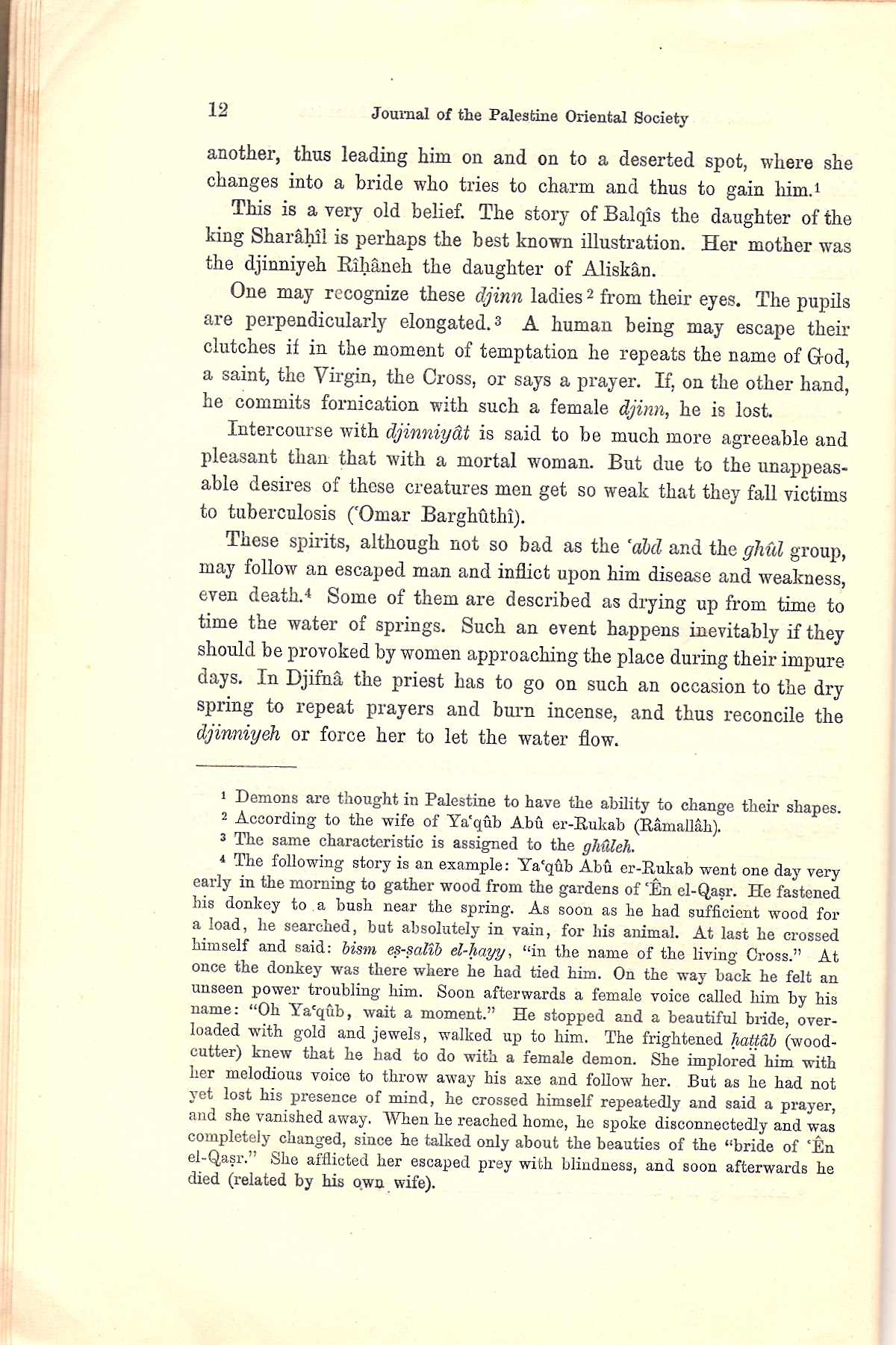
A legend exists about Jifna's spring—which the village has used for centuries—concerning how it periodically runs low on water.
Like many Palestinian villages, the women of Jifna have their own
Festivals
In April–May 2005 Jifna hosted the first annual International Artists' Workshop in Palestine. The festival, known as the "Jifna Spring" was the first held in a rural village instead of a major city such as Hebron or Ramallah. During the festival, dozens of artists from all over the world collaborated on several projects, including stone sculptures, metalwork, photography, mural paintings and installation pieces. Many of the works were influenced by the "specificity and qualities" of Jifna, while others dealt with the subject of Palestinian identity.[73]
Jifna, locally famous for its apricot harvest, hosts an annual two-day apricot festival in the first week of May. Hundreds of West Bankers flock to participate in the harvest.[8] The festival is also used by Palestinian politicians as an opportunity to give speeches praising Palestinian farmers and encouraging boycotts on Israeli products and reliance on domestic agriculture.[74]
Local government
Jifna is governed by a
Education
Jifna contains one gender-mixed primary school and kindergarten, founded by the
See also
- Abeer Odeh
- Alex Odeh
- Palestinian Christians
- Arab Christian
- History of Palestine
References
- ^ a b Jifna Council Members, Jifna Village Council, 2005-09-05, archived from the original on January 9, 2008, retrieved 2009-05-07
- ^ a b Preliminary Results of the Population, Housing and Establishments Census, 2017 (PDF). Palestinian Central Bureau of Statistics (PCBS) (Report). State of Palestine. February 2018. pp. 64–82. Retrieved 2023-10-24.
- ^ Palmer, 1881, p. 230
- ^ a b c d Jifna Excerpt, Palestinian Association of Cultural Heritage, archived from the original on 2007-08-11, retrieved 2009-04-14
- ^ Madaba Map, 6th cent.
- ^ a b c d e f g h i j k l m n o p q r Discussion Mount Ephraim and Benjamin: 51. Gophna (Jifna), Studium Biblicum Franciscanum–Jerusalem, 2001-12-19, archived from the original on 2016-03-05, retrieved 2009-05-05
- ^ a b c History of Jifna, Jifna Hope Association, archived from the original on 2008-09-08, retrieved 2009-04-14
- ^ a b c Farsakh, Mai M. (2006-06-21), "The rich flavors of Palestine", This Week in Palestine, Institute for Middle East Understanding, archived from the original on 2009-04-16, retrieved 2009-04-14
- ^ Donner, 1992, p. 50.
- ^ Tosefta (Oheloth 18:16)
- ^ Cf. Talmud, Berakhot 44a
- ^ Goodrich-Frier, 1905, p. 186.
- ^ Other texts put the commander as "John, the son of Matthias." See: Wars 2.20.4.
- Wars of the Jews) V, 47 (Wars of the Jews 5.2.1)
- ^ a b Robinson, 1860, pp.262–264.
- ^ Grey, M.J. (2011), Jewish Priests and the Social History of post-70 Palestine, Chapel Hill: University of North Carolina, p. 159
- ^ ISSN 0792-8416.
- ^ )
- ^ Benoit, P. (1960). "Textes Grecset Latins". In Benoit, P.; Milik, J.T.; de Vaux, R. (eds.). Discoveries in the Judaean Desert. Vol. II. Oxford. pp. 209–280.
- ^ a b Robinson & Smith, 1841, vol 3, p. 79
- ^ Van de Velde, 1858, p. 317.
- ^ Klein, E, 2011, “Gophna during the Late Roman Period in Light of Artistic and Epigraphic Finds”, in: A. Tavger., Z. Amar and M. Billig (eds.), In the Highland’s Depth: Ephraim Range and Binyamin Research Studies, Beit-El, pp. 119-134 (Hebrew).
- ^ a b c d e The Village and tower of Jifna – Ramallah, Jerusalem Media and Communications Centre., archived from the original on October 11, 2008, retrieved 2009-04-14
- ^ Gil, 1997, p. 43.
- ^ Boas, 1999, p. 74.
- ^ Röhricht, 1893, p. 162
- ^ Chase, 2003, pp. 104–105.
- ^ a b Hütteroth and Abdulfattah, 1977, p. 114. Note that they write that the whole population was Muslim, however Toledano, 1984, p. 312, writes that the village was wholly Christian in all the defters of the 16th century.
- ^ Singer, 1994, p. 77.
- ^ a b Robinson and Smith, 1841, p. 78 -80
- ^ Conder and Kitchener, 1882, SWP II, p. 323
- ^ Conder and Kitchener, 1883, SWP III, pp. 437-438
- ^ Conder and Kitchener, 1882, SWP II, p. 294
- ^ Oliphant, 1881, pp. 269–271.
- ^ a b Kramer and Harman, 2008, p. 163.
- ^ Kramer and Harman, 2008, pp. 319–320.
- ^ Palestine Facts Timeline: 1994–1995 Archived 2016-04-19 at the Wayback Machine Palestinian Academic Society for the Study of International Affairs. Retrieved on 2009-05-05.
- ^ a b Sharp, Heather, "In pictures: Christmas in the West Bank: Restrictions", BBC News, BBC MMVII, retrieved 2009-04-14
- ^ [1] Ha'aretz 1 August 2015
- ^ ABU TOAMEH, KHALED. "GUNMEN ATTACK CHRISTIANS NEAR RAMALLAH AFTER DISPUTE INVOLVING PA OFFICIAL". Retrieved 28 April 2019.
- ^ a b c Government of Palestine, Department of Statistics. Village Statistics, April, 1945. Quoted in Hadawi, 1970, p. 64. Retrieved on 2009-05-05.
- ^ Government of Palestine, Department of Statistics. Village Statistics, April, 1945. Quoted in Hadawi, 1970, p. 162
- United Nations Office of the Coordination of Humanitarian Affairs, January 2006, retrieved 2009-04-14
- ^ a b "Monthly Averages in Ramallah, the West Bank", USA Today, retrieved 2009-04-14
- ^ About Ramallah, Ramallah Online Archive, retrieved 2009-04-14[permanent dead link]
- ^ a b Socin, 1879, p. 153
- ^ a b Hartmann, 1883, p. 126, also noted 56 houses
- ^ a b Schick, 1896, p. 121
- ^ 1922 census of Palestine, given in Barron, 1923, Table VII, Sub-district of Ramallah, p. 16. The total population was Christian.
- ^ Sabeel Ecumenical Liberation Theology Center, p. 10, retrieved 2009-04-14
- ^ a b 1931 census of Palestine, as given in Mills, 1932, p. 49 169 were Muslim, while 507 were Christian
- ^ a b Government of Palestine, Department of Statistics, 1945, p. 26
- ^ Government of Jordan, Department of Statistics, 1964, p. 24 It was further noted (note 2) that it was governed through a village council.
- ^ a b Collings, Rania al-Qass; Kassis, Rifaat Odeh; Raheb, Mitri, Palestinian Christians Facts, Figures and Trends 2008 (PDF), Diyar, p. 35, archived from the original (PDF) on 2010-03-07, retrieved 2009-06-12
- ^ a b Palestinian Population by Locality and Refugee Status, Palestinian Central Bureau of Statistics, archived from the original on 2008-11-19, retrieved 2009-05-05
- ^ a b c 2007 Census Final Results (PDF), Palestinian Central Bureau of Statistics, archived from the original (PDF) on 2010-12-10, retrieved 2009-04-14
- ^ Palestinian Population by Locality, Sex and Age Groups in Years, Palestinian Central Bureau of Statistics, archived from the original on 2008-11-19, retrieved 2009-05-05
- ^ Projected Mid-Year Population for Ramallah & Al Bireh Governorate by Locality 2004–2006, Palestinian Central Bureau of Statistics, archived from the original on 2009-03-04, retrieved 2009-04-14
- ^ a b c Ellenblum, 2003, pp. 135–136
- ^ Occupied Housing Units by Locality and Connection to Electricity Network in Housing Unit, Palestinian Central Bureau of Statistics, 1997, archived from the original on 2008-11-19, retrieved 2009-05-06
- ^ Occupied Housing Units by Locality and Connection to Sewage System in Housing Unit, Palestinian Central Bureau of Statistics, 1997, archived from the original on 2008-11-19, retrieved 2009-05-06
- ^ Occupied Housing Units by Locality and Connection to Water Network in Housing Unit, Palestinian Central Bureau of Statistics, 1997, archived from the original on 2008-11-19, retrieved 2009-05-06
- ^ Jifna Village History, Jifna Village Council, archived from the original on January 9, 2008, retrieved 2009-05-06
- ^ Palestinian Restaurants Directory, Jerusalem Media and Communications Centre, archived from the original on 2009-03-03, retrieved 2009-04-14
- ^ Palestinian Restaurants Directory, Palestinian Hotels Directory, archived from the original on June 2, 2008, retrieved 2009-04-14
- ^ a b Kershner, Isabel (2006-11-26), "The Losing Battle", The Jerusalem Report, Palestinian Academic Society for the Study of International Affairs, retrieved 2009-04-14
- ^ Al-Burj Restaurant–Jifna Village–Ramallah, Jerusalem Media and Communications Centre, archived from the original on 2009-02-23, retrieved 2009-04-14
- ^ About Tabash Restaurant, Tabash Restaurant, archived from the original on 2008-10-11, retrieved 2009-04-15
- ^ Liévin de Hamme, 1876, p. 20
- ^ Durward, 1913, p. 116.
- ^ Canaan, 1922, p. 12.
- ^ Traditional Palestinian dress, Universal Workshop, retrieved 2009-05-07
- ^ Sherwell, Tina (June 2005), Jifna Spring 2005, ArtSchool Palestine, retrieved 2009-05-07
- ^ Apricot Festival launched in Jifna on Thursday, Ma'an News Agency, 2006-06-16, retrieved 2009-05-07
- ^ About the Council Jifna Village Council.
- ^ a b Jifna Today: Schools Archived 2008-09-08 at the Wayback Machine Jifna Village Council
- ^ "Latin Patriarchate of Jerusalem". Archived from the original on October 30, 2006.
Bibliography
- Barron, J.B., ed. (1923). Palestine: Report and General Abstracts of the Census of 1922. Government of Palestine.
- Boas, Adrian (1999). Crusader Archaeology: The Material Culture of the Latin East. Routledge. ISBN 0-415-17361-2.
- Canaan, T. (1922). Haunted Springs and Water Demons in Palestine. Jerusalem: Palestine Oriental Society.
- Conder, C.R.; Kitchener, H.H. (1882). The Survey of Western Palestine: Memoirs of the Topography, Orography, Hydrography, and Archaeology. Vol. 2. London: Committee of the Palestine Exploration Fund.
- Conder, C.R.; Kitchener, H.H. (1883). The Survey of Western Palestine: Memoirs of the Topography, Orography, Hydrography, and Archaeology. Vol. 3. London: Committee of the Palestine Exploration Fund.
- Chase, Kenneth (2003). Firearms: A Global History to 1700. Cambridge University Press. ISBN 0-521-82274-2.
- ISBN 0-860549-05-4.
- Donner, Herbert Kampen (1992). The Mosaic Map of Madaba. Peeters Publishers. ISBN 90-390-0011-5.
- Durward, John T (1913). Holy Land and Holy Writ. Pilgrim Pub and Co.
- ISBN 9780521521871.
- ISBN 965-440-007-3. (II, pp. 543– 547)
- ISBN 0-521-59984-9.
- Goodrich-Freer, A. (1905). In a Syrian Saddle. Methuen and Co.
- Government of Jordan, Department of Statistics (1964). First Census of Population and Housing. Volume I: Final Tables; General Characteristics of the Population (PDF).
- Government of Palestine, Department of Statistics (1945). Village Statistics, April, 1945.
- Guérin, V. (1869). Description Géographique Historique et Archéologique de la Palestine (in French). Vol. 1: Judee, pt. 3. Paris: L'Imprimerie Nationale. (p. 28 −32)
- Guérin, V. (1875). Description Géographique Historique et Archéologique de la Palestine (in French). Vol. 2: Samarie, pt. 2. Paris: L'Imprimerie Nationale. (p. 39 )
- Hadawi, S. (1970). Village Statistics of 1945: A Classification of Land and Area ownership in Palestine. Palestine Liberation Organization Research Centre.
- Hartmann, M. (1883). "Die Ortschaftenliste des Liwa Jerusalem in dem türkischen Staatskalender für Syrien auf das Jahr 1288 der Flucht (1871)". Zeitschrift des Deutschen Palästina-Vereins. 6: 102–149.
- Hütteroth, Wolf-Dieter; Abdulfattah, Kamal (1977). Historical Geography of Palestine, Transjordan and Southern Syria in the Late 16th Century. Erlanger Geographische Arbeiten, Sonderband 5. Erlangen, Germany: Vorstand der Fränkischen Geographischen Gesellschaft. ISBN 3-920405-41-2.
- ISBN 978-0-691-11897-0.
- Liévin de Hamme (1876). Guide-indicateur des sanctuaires et lieux historiques de la Terre -Sainte. Venice: F.et J. Lefever.
- Mills, E., ed. (1932). Census of Palestine 1931. Population of Villages, Towns and Administrative Areas. Jerusalem: Government of Palestine.
- Oliphant, L. (1881). The Land of Gilead: With Excursions in the Lebanon. D. Appleton.
- Palmer, E.H. (1881). The Survey of Western Palestine: Arabic and English Name Lists Collected During the Survey by Lieutenants Conder and Kitchener, R. E. Transliterated and Explained by E.H. Palmer. Committee of the Palestine Exploration Fund.
- )
- ISBN 9780521460101. (p. 57)
- Robinson, E. (1860). Biblical Researches in Palestine, and in the Adjacent Regions. Crocker and Brewster. p. 263.
Jufna Palestine.
- Robinson, E.; Smith, E. (1841). Biblical Researches in Palestine, Mount Sinai and Arabia Petraea: A Journal of Travels in the year 1838. Vol. 3. Boston: Crocker & Brewster.
- Röhricht, R. (1893). Regista Regni Hierosolymitani (1097–1291). Oeniponti : Libraria Academica Wagneriana.
- Schick, C. (1896). "Zur Einwohnerzahl des Bezirks Jerusalem". Zeitschrift des Deutschen Palästina-Vereins. 19: 120–127.
- ISBN 0-521-47679-8.
- Socin, A. (1879). "Alphabetisches Verzeichniss von Ortschaften des Paschalik Jerusalem". Zeitschrift des Deutschen Palästina-Vereins. 2: 135–163.
- Toledano, E. (1984). "The Sanjaq of Jerusalem in the Sixteenth Century: Aspects of Topography and Population". Archivum Ottomanicum. 9: 279–319.
- van de Velde, C.W.M. (1858). Memoir to Accompany the Map of the Holy Land. Gotha: Justus Perthes.
External links
- Jifna Village Council Official Website. (in Arabic)
- Jifna Village Council Official Website. (in English)
- Welcome To Jifna
- Jifna, Welcome to Palestine
- Survey of Western Palestine, Map 14: IAA, Wikimedia commons
- Jifna Village (Fact Sheet), Applied Research Institute–Jerusalem (ARIJ)
- Jifna Village Profile (including Al Doha Locality), ARIJ
- Jifna, aerial photo, ARIJ
 | ||||
| Municipalities |
| |||
Village councils |
| |||
Refugee camps |
| |||