
Dover, New Hampshire
Dover, New Hampshire | ||
|---|---|---|
 City Hall | ||
|
City Council Members
| ||
| • FIPS code | 33-18820 | |
| GNIS feature ID | 0866618 | |
| Website | www | |
Dover is a city in Strafford County, New Hampshire, United States. The population was 32,741 at the 2020 census,[2] making it the most populous city in the New Hampshire Seacoast region and the 5th most populous city in New Hampshire.
It is the county seat of Strafford County, and home to Wentworth-Douglass Hospital, the Woodman Institute Museum, and the Children's Museum of New Hampshire.
Etymology
The city is named for
History
Settlement

The first known European to explore the region was Martin Pring from Bristol, England, in 1603.
In 1623, brothers William and Edward Hilton settled at Pomeroy Cove on Dover Point, near the confluence of the Bellamy and Piscataqua rivers. This first settlement makes Dover the oldest permanent settlement in New Hampshire, and seventh in the United States.[3]
The Hiltons were fishmongers sent from London by the Council for New England's Laconia Company to establish a colony and fishery on the Piscataqua. In 1631, however, the colony contained only three houses. William Hilton built a salt works on the property (salt-making was the principal industry in his hometown of Northwich, England). He also served as Deputy to the General Court (the colonial legislature).[4][5][6] The Hiltons' name survives at Hilton Park on Dover Point (originally known as Hilton Point).
The colony's original townships included Durham, Madbury, Newington, Lee, Somersworth and Rollinsford.
In 1633, the plantation was bought by a group of English
The town was called Dover in 1637 by the new governor, Reverend
Because it was an early settlement in Abenaki lands, settlers built fortified
What is now downtown Dover settlers called Cochecho village.Cochecho Massacre
On June 28, 1689, Dover suffered a devastating attack by Native Americans. It was revenge for an incident on September 7, 1676, when 400 Native Americans were tricked by Major
Incursions against the frontier town would continue for the next half century. During
Mill era

Located at the head of
The mills were purchased in 1909 by the Pacific Mills of Lawrence, Massachusetts, which closed the printery in 1913 but continued spinning and weaving. The printery buildings were demolished in 1913, their site is now Henry Law Park.
In 1922, it was affected by the 1922 New England Textile Strike, shutting down the mills in the city over an attempted wage cut and hours increase.[14][15]
During the Great Depression, however, textile mills no longer dependent on New England water power began moving to southern states in search of cheaper operating conditions, or simply went out of business. Dover's millyard shut in 1937, then was bought at auction in 1941 by the city itself for $54,000. There were no other bids. Now called the Cocheco Falls Millworks, its tenants include technology and government services companies, plus a restaurant, brewery and bar.[16][17]
Textile manufacturing in Dover wasn't limited to cotton. In 1824, Alfred I. Sawyer established the Sawyer Woolen Mills beside the Bellamy River. It would expand to include 15 major buildings over 8.5 acres (3.4 ha), and by 1883 was the largest woolen manufacturer in the state.[11] In 1889 it was acquired by the American Woolen Company, but closed and was sold off in 1955. The buildings have been repurposed into housing.
Modern era
With the closing of the mills, the downtown area of Dover sat vacant and lifeless for a long time. With the turn of the century, the city government began to revitalize the area. The Children's Museum of New Hampshire was brought into a disused mill building with a lease of $1 a year. Henry Law Park, a grassy waterfront stretch of land, was given a brand new playground. Small businesses moved into the mills, such as restaurants, toy stores, real estate offices, and barber shops. Old buildings have been refurbished or outright rebuilt to provide new housing. An $87.5 million high school was built to handle the influx of new residents retreating from the high housing prices in Portsmouth. Recently, a plan to develop the waterfront on the other side of the river from the traditional downtown area was approved for $6 million.[18][19] In early May 2021, waypoint signs were sporadically added to help drivers and walkers navigate Dover with the expansions that are underway.
Antique postcards
-
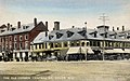 The Old Corner c. 1892
 -
 Central Square c. 1905
 -
 Public Library c. 1907
 -
 Guppy House c. 1910
 -
 Old Brick Schoolhouse c. 1910, once located near Pine Hill Cemetery
 -

-
 Whitcher's Falls c. 1910
 -
 Pacific Mills c. 1912
 -
 Downtown c. 1913


Geography and transportation

According to the United States Census Bureau, the city has a total area of 29.0 square miles (75.2 km2), of which 26.7 square miles (69.2 km2) are land and 2.3 square miles (6.0 km2) are water, comprising 7.97% of the city.[20] Dover is drained by the Cochecho and Bellamy rivers, both of which flow into the tidal Piscataqua River,[21] which forms the city's eastern boundary and the New Hampshire–Maine border. Long Hill, elevation greater than 300 feet (91 m) above sea level and located 3 miles (5 km) northwest of the city center, is the highest point in Dover. Garrison Hill, elevation approximately 290 ft (88 m), is a prominent hill rising directly above the center city, with a park and lookout tower on top.
The city is crossed by New Hampshire Routes 4, 9, 16 (the Spaulding Turnpike), 108, and 155, plus U.S. Route 4. It is bordered by the town of Newington to the south (across the inlet to Great Bay), Madbury to the southwest, Barrington and Rochester to the northwest, and Somersworth and Rollinsford to the northeast. South Berwick, Maine, lies to the northeast, across the tidal Salmon Falls River, and Eliot, Maine, is to the east, across the Piscataqua River.
The Cooperative Alliance for Seacoast Transportation (COAST) operates a publicly funded bus network in Dover and surrounding communities in New Hampshire and Maine.[22] C&J Bus Lines is a private intercity bus carrier currently connecting Dover with Boston's South Station and Logan Airport, as well as New York City (via Midtown Manhattan's Port Authority Bus Terminal).[23] Wildcat Transit, operated by the University of New Hampshire, provides bus service to Durham, which is free for students and $1.50 for the public.[24] Amtrak's Downeaster train service stops at the Dover Transportation Center with service to the Portland Transportation Center, Boston's North Station, and intermediate stops.
Demographics
| Census | Pop. | Note | %± |
|---|---|---|---|
| 1790 | 1,998 | — | |
| 1800 | 2,062 | 3.2% | |
| 1810 | 2,228 | 8.1% | |
| 1820 | 2,871 | 28.9% | |
| 1830 | 5,449 | 89.8% | |
| 1840 | 6,458 | 18.5% | |
| 1850 | 8,196 | 26.9% | |
| 1860 | 8,502 | 3.7% | |
| 1870 | 9,294 | 9.3% | |
| 1880 | 11,687 | 25.7% | |
| 1890 | 12,790 | 9.4% | |
| 1900 | 13,207 | 3.3% | |
| 1910 | 13,247 | 0.3% | |
| 1920 | 13,029 | −1.6% | |
| 1930 | 13,573 | 4.2% | |
| 1940 | 13,990 | 3.1% | |
| 1950 | 15,874 | 13.5% | |
| 1960 | 19,131 | 20.5% | |
| 1970 | 20,850 | 9.0% | |
| 1980 | 22,377 | 7.3% | |
| 1990 | 25,042 | 11.9% | |
| 2000 | 26,884 | 7.4% | |
| 2010 | 29,987 | 11.5% | |
| 2020 | 32,741 | 9.2% | |
| 2022 (est.) | 33,416 | 2.1% | |
| U.S. Decennial Census[25] | |||
As of the 2020 census, there were 32,741 people, 14,431 households, and 7,059 families residing in the city. The city grew by 2,754 residents between 2010 and 2020, the third-largest numeric growth of a town or city in New Hampshire, after Manchester and Nashua. The population density in 2020 was 1,224.88 people per square mile (472.93/km2). There were 15,166 housing units at an average density of 567.38 per square mile (219.07/km2). The racial makeup of the city was 87.2% White, 1.7% African American, 0.20% Native American, 5.1% Asian, 0.01% Pacific Islander, 1.2% some other race, and 4.6% from two or more races. Hispanic or Latino of any race were 2.9% of the population.[26]
There were 12,827 households, out of which 27.8% had children under the age of 18 living with them, 40.8% were headed by married couples living together, 10.3% had a female householder with no husband present, and 45.0% were non-families. 31.8% of all households were made up of individuals, and 9.6% were someone living alone who was 65 years of age or older. The average household size was 2.27, and the average family size was 2.89.[26]
In the city, the population was spread out, with 20.3% under the age of 18, 11.0% from 18 to 24, 30.6% from 25 to 44, 24.9% from 45 to 64, and 13.1% who were 65 years of age or older. The median age was 36.7 years. For every 100 females, there were 96.0 males. For every 100 females age 18 and over, there were 94.0 males.[26]
For the period 2009–2011, the estimated median annual income for a household in the city was $55,040, and the median income for a family was $69,980. Male full-time workers had a median income of $51,891 versus $36,167 for females. The
Education
The Dover School District serves approximately 4,000 pupils, attending Horne Street Elementary School, Garrison Elementary School, Woodman Park Elementary School, Dover Middle School and Dover High School. Dover High's athletic teams are known as "The Green Wave," and the middle school's teams are "The Little Green."
Saint Mary Academy, a
Portsmouth Christian Academy is located west of the Bellamy River in Dover, serving preschool through 12th grade.[28]
The Cocheco Arts and Technology Academy (CATA) is a public charter high school with about 100 students. It was formerly located in Barrington, New Hampshire.
The Seacoast Charter School is a publicly funded elementary/middle school that integrates the arts into the core curriculum. The school was founded in 2004 in Kingston, New Hampshire, and relocated to Dover in 2015. Enrollment in January 2016 was 215 students in grades K–8.[29]
Government
| Year | Democratic | Republican | Third parties
|
|---|---|---|---|
| 2020 | 65.19% 12,508 | 32.99% 6,331 | 1.80% 346 |
| 2016 | 58.17% 10,118 | 34.58% 6,015 | 7.25% 1,262 |
| 2012 | 59.85% 9,724 | 37.93% 6,162 | 2.22% 360 |
| 2008 | 63.17% 10,221 | 35.51% 5,746 | 1.32% 214 |
| 2004 | 59.39% 9,225 | 39.95% 6,206 | 0.66% 103 |
| 2000 | 54.32% 6,812 | 39.94% 5,008 | 5.74% 720 |
| 1996 | 56.38% 6,332 | 33.41% 3,752 | 10.21% 1,147 |
| 1992 | 45.45% 5,449 | 35.01% 4,197 | 19.54% 2,342 |
| 1988 | 46.59% 4,803 | 51.97% 5,357 | 1.44% 148 |
| 1984 | 41.32% 3,826 | 58.29% 5,397 | 0.39% 36 |
| 1980 | 35.14% 3,344 | 47.26% 4,497 | 17.60% 1,675 |
| 1976 | 49.53% 4,386 | 47.48% 4,204 | 2.99% 265 |
| 1972 | 42.94% 3,697 | 56.39% 4,855 | 0.66% 57 |
| 1968 | 51.12% 4,101 | 47.08% 3,777 | 1.81% 145 |
| 1964 | 68.53% 5,629 | 31.47% 2,585 | 0.00% 0 |
| 1960 | 52.34% 4,697 | 47.66% 4,277 | 0.00% 0 |
In the
Dover is a Democratic stronghold in presidential elections. No Republican presidential nominee has carried Dover since George H. W. Bush’s five-point victory in the town over Michael Dukakis in 1988.
Notable people
In popular culture

Dover was used as the fictional setting for the Hallmark Channel movie Christmas Incorporated.
Dover was the birthplace of the Teenage Mutant Ninja Turtles franchise, created by comic book writers Kevin Eastman and Peter Laird and first published by Mirage Studios—then based in Dover—in 1984.
Historic sites
- First Parish Church
- New Hampshire Historical Marker No. 51: Dr. Jeremy Belknap (1744–1798)
- New Hampshire Historical Marker No. 92: Hilton's Point – 1623
- New Hampshire Historical Marker No. 165: The Alexander Scammell Bridge over the Bellamy River
- New Hampshire Historical Marker No. 264: Home of John Parker Hale, 1840–1873
- New Hampshire Historical Marker No. 282: Native Retribution Against Maj. Waldron
- New Hampshire Historical Marker No. 289: Creation of the Teenage Mutant Ninja Turtles
- Religious Society of Friends Meetinghouse
- St. Thomas Episcopal Church
- Woodman Institute
See also
- Dover Transportation Center
- McIntosh College
- 1987 Little League World Series, when a team from Dover advanced to the quarter-finals
References
- Notes
- ^ "ArcGIS REST Services Directory". United States Census Bureau. Retrieved September 20, 2022.
- ^ "Dover city, Strafford County, New Hampshire: 2020 DEC Redistricting Data (PL 94-171)". U.S. Census Bureau. Retrieved January 4, 2022.
- ISBN 978-1-115-84294-5.
- ISBN 0-9676579-0-3.
- ^ Anderson, R. C. The Great Migration Begins: Immigrants to New England, 1620-1633, pp. 951–957, vol. 2, New England Historical and Genealogical Society, Boston, 1995.
- ^ Scales, J. History of Dover, New Hampshire, pp. 311–313, facsimile of the 1923 edition, Heritage Books, 1989.
- ^ Jeremy Belknap, The History of New Hampshire, 1812
- ^ Haddon 2004, pp. 64–65
- ^ Dover Public Library, "Is it Spelled Cochecho or Cocheco?" Archived 2015-07-07 at the Wayback Machine
- ^ William Williamson, p. 123.
- ^ a b Garland, Caroline Harwood, Old Dover, New Hampshire; Castle Books, Edison, NJ 1987, 2002, p. 383.
- ^ "The Strike of the Mill Girls". Dover Public Library. Retrieved January 27, 2024.
- ^ Hindle, Thom; Dover, Images of America; Arcadia Publishing, Portsmouth, NH 1994, p. 69.
- ISBN 978-0-7178-0674-4.
- ^ E. Tilden, Leonard (1923). "New England Textile Strike". Monthly Labor Review. 16 (5): 13–36 – via JSTOR.
- ^ "Cocheco Falls Millworks". Cocheco Falls Millworks. Archived from the original on March 30, 2012. Retrieved August 15, 2011.
- ^ Beaudoin, Cathleen. "A Yarn to Follow: The Dover Cotton Factory 1812—1821". Dover Public Library. Archived from the original on February 23, 2003. Retrieved August 15, 2011.
- ^ "Dover's Economic Explosion". www.businessnhmagazine.com. Retrieved December 4, 2019.
- ^ "Dover, N.H., reinvents itself into a destination - The Boston Globe". BostonGlobe.com. Retrieved December 4, 2019.
- ^ "2021 U.S. Gazetteer Files – New Hampshire". United States Census Bureau. Retrieved January 4, 2022.
- ^ Foster, Debra H.; Batorfalvy, Tatianna N.; Medalie, Laura (1995). Water Use in New Hampshire: An Activities Guide for Teachers. U.S. Department of the Interior and U.S. Geological Survey.
- ^ "Take a closer look at COAST". www.coastbus.org. Retrieved July 6, 2010.
- ^ "Dover NH to Logan Airport and New York City will Resume in February of 2024". www.ridecj.com. Retrieved November 20, 2023.
- ^ "Wildcat Transit". Retrieved April 21, 2012.
- ^ "Census of Population and Housing". Census.gov. Retrieved June 4, 2016.
- ^ a b c "Profile of General Population and Housing Characteristics: 2020 Demographic Profile Data (DP-1): Dover city, New Hampshire". U.S. Census Bureau, American Factfinder. Archived from the original on February 12, 2020. Retrieved August 13, 2021.
- ^ "Selected Economic Characteristics: 2009-2011 American Community Survey 3-Year Estimates (DP03): Dover city, New Hampshire". U.S. Census Bureau, American Factfinder. Archived from the original on February 12, 2020. Retrieved February 11, 2013.
- ^ "Portsmouth Christian Academy - In the News". www.pcaschool.org. Archived from the original on August 12, 2014. Retrieved July 6, 2010.
- ^ "The Seacoast Charter School". Retrieved January 13, 2016.
- ^ "Election Results". sos.nh.gov.
- Bibliography
- Haddon, Celia (2004), The First Ever English Olimpick Games, Hodder & Stoughton, ISBN 0-340-86274-2
External links
- Official website
- Sketch of Dover, New Hampshire
- New Hampshire Economic and Labor Market Information Bureau Profile
- Dover, NH Annual Reports
- LIFE Magazine (Sept. 17, 1971) article about Tuttle farm
Places adjacent to Dover, New Hampshire | |
|---|---|
 | ||||
| Towns | ||||
| CDPs | ||||
Other villages | ||||
| ||||
| International | |
|---|---|
| National | |
| Geographic | |