
Groundwater on Mars

Rain and snow was a regular occurrence on
Overviews
Researchers have found that Mars had a planet-wide groundwater system and several prominent features on the planet have been produced by the action of
In an aquifer, water occupies open space (pore space) that lies between rock particles. This layer would spread out, eventually coming to be under most of the Martian surface. The top of this layer is called the water table. Calculations show that the water table on Mars was for a time 600 meters below the surface.[14][15]
The InSight lander uncovered in September 2019 unexplained magnetic pulses, and magnetic oscillations consistent with an existing planet-wide reservoir of liquid water deep underground.[8]
Researchers have concluded that Gale Crater has experienced many episodes of groundwater surge with changes in the groundwater chemistry. These chemical changes would support life.[16][17][18][19][20][21]
Layered terrain

Some locations on the Red Planet show groups of layered rocks. It has been suggested that the layers were put into place by volcanoes, the wind, or by being at the bottom of a lake or sea. Calculations and simulations show that groundwater carrying dissolved minerals would surface in the same locations that have abundant rock layers. According to these ideas, deep canyons and large craters would receive water coming from the ground. Many craters in the Arabia area of Mars contain groups of layers. Some of these layers may have resulted from climate change.
The tilt of the rotational axis of Mars has repeatedly changed in the past. Some changes are large. Because of these variations of climate, at times the atmosphere of Mars would have been much thicker and contained more moisture. The amount of atmospheric dust also has increased and decreased. It is believed that these frequent changes helped to deposit material in craters and other low places. The rising of mineral-rich ground water cemented these materials. The model also predicts that after a crater is full of layered rocks, additional layers will be laid down in the area around the crater. So, the model predicts that layers may also have formed in intercrater regions; layers in these regions have been observed.
Layers can be hardened by the action of groundwater. Martian ground water probably moved hundreds of kilometers, and in the process it dissolved many minerals from the rock it passed through. When ground water surfaces in low areas containing sediments, water evaporates in the thin atmosphere and leaves behind minerals as deposits and/or cementing agents. Consequently, layers of dust could not later easily erode away since they were cemented together. On Earth, mineral-rich waters often evaporate forming large deposits of various types of
In February 2019, European scientists published geological evidence of an ancient planet-wide groundwater system that was, arguably, connected to a putative vast ocean.[29][30]
Layers in Crommelin crater
-
 Butte in Crommelin crater, as seen by HiRISE under HiWish program. Location is Oxia Palus quadrangle.
 -
 Layers as seen by HiRISE
 -
 Layers as seen by HiRISE. Arrow indicates fault.


Layers in Danielson crater
-
 Layered mound on floor of Danielson crater, as seen by HiRISE under HiWish program
 -
 Close, color view of layers and dark dust on floor, as seen by HiRISE
 -
 Close, color view of layers and dark dust on floor, as seen by HiRISE. Boulders are visible in the image.
 -
 Close view of layers on floor, as seen by HiRISE. Some faults are visible in image.
 -
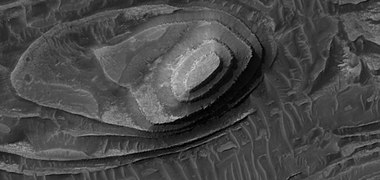
 Layers seen by HiRISE. The box represents the size of a football field.
 -
 Close up of layers as seen by HiRISE. Boulders are visible, as well as dark sand.


Inverted terrain
Many areas on Mars show inverted relief. In those places, former stream channels are displayed as raised beds, instead of stream valleys. Raised beds form when old stream channels become filled with material that is resistant to erosion. After later erosion removes surrounding soft materials, more resistant materials that were deposited in the stream bed are left behind. Lava is one substance that can flow down valleys and produce such inverted terrain. However, fairly loose materials can get quite hard and erosion resistant when cemented by minerals. These minerals can come from groundwater. It is thought that a low point, like a valley focuses groundflow, so more water and cements move into it, and this results in a greater degree of cementation.[9]
Terrain inversion can also happen without cementation by groundwater, however. If a surface is being eroded by wind, the necessary contrast in erodibility can arise simply from variations in grain size of loose sediments. Since wind can carry away sand but not cobbles, for example, a channel bed rich in cobbles could form an inverted ridge if it was originally surrounded by much finer sediments, even if the sediments were not cemented. This effect has been invoked for channels in Saheki crater.[31]
Places on Mars that contain layers in the bottoms of craters often also have inverted terrain.
-

-
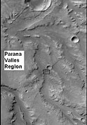 CTX context image for next image that was taken with HiRISE. Note long ridge going across image is probably an old stream. Box indicates area for HiRISE image. Image located in Margaritifer Sinus quadrangle.
 -
 Example of inverted terrain inParana Vallesregion, as seen by HiRISE.


Evidence for groundwater upwelling
Spacecraft sent to Mars provided a wealth of evidence for groundwater being a major cause of many rock layers on the planet. The
-
 Holes (Vugs) in bedrock in the shape of crystals that were there, but have since been dissolved, as seen by Opportunity Rover. The holes have the shape of the original crystals.
 -
 "Blueberries" (hematite spheres) on a rocky outcrop at Eagle Crater. Note the merged triplet in the upper left.


Orbiting probes showed that the type of rock around Opportunity was present in a very large area that included Arabia, which is about as large as
Strong evidence for groundwater making lakes in deep craters was described by a group of European scientists in February 2019.[29][30][44][45] Craters examined did not show inlets or outlets; therefore, water for the lake would have come from the ground. These craters had floors lying roughly 4000 m below Martian 'sea level'. Features and minerals on the floors of these craters could only have formed in the presence of water. Some of the features were deltas and terraces.[46][44] Some of the craters studied were Oyama, Pettit, Sagan, Tombaugh, Mclaughlin, du Martheray, Nicholson, Curie, and Wahoo. It seems that if a crater was deep enough, water came out of the ground and a lake was formed.[44]
Pedestal craters
-
 Tikhonravov crater floor with two pedestal craters, as seen by Mars Global Surveyor. Image in Arabia quadrangle.
 -
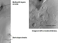
 Dark slope streaks and layers near the top of a pedestal crater, as seen by HiRISE. Image in Arabia quadrangle.
 -
 Pedestal craters form when the ejecta from impacts protect the underlying material from erosion. As a result of this process, craters appear perched above their surroundings.
 -
 Dark slope streaks and layers near a pedestal crater, as seen by HiRISE. Layers were protected by the top of the pedestal crater. Image in Arabia quadrangle.


See also
- Arabia quadrangle – Map of Mars
- Climate of Mars – Climate patterns of the planet Mars
- Equatorial layered deposits – Surface geological deposits on Mars
- Geology of Mars – Scientific study of the surface, crust, and interior of the planet Mars
- Lakes on Mars – Overview of the presence of lakes on Mars
- Mars Reconnaissance Orbiter – NASA spacecraft active since 2005
- Opportunity (rover) – NASA Mars rover deployed in 2004
- Pedestal crater – type of impact crater
- Seasonal flows on warm Martian slopes, also known as Recurring slope lineae – Surface features on Mars
- Water on Mars – Study of past and present water on Mars
References
- .
- .
- .
- ^ Baker, V. R. (1982), The Channels of Mars, 198 pp., Univ. of Tex. Press, Austin.
- .
- .
- .
- ^ a b Andrews, Robin George (20 September 2019). "Mysterious magnetic pulses discovered on Mars - The nighttime events are among initial results from the InSight lander, which also found hints that the red planet may host a global reservoir of liquid water deep below the surface". National Geographic Society. Archived from the original on 20 September 2019. Retrieved 20 September 2019.
- ^ S2CID 4428510.
- PMID 31007995.
- .
- .
- doi:10.1038/ngeo831.
- S2CID 17293290.
- .
- .
- ^ L'Haridon, J., N. Mangold, W. Rapin, O. Forni, P.-Y. Meslin, E. Dehouck, M. Nachon, L. Le Deit, O. Gasnault, S. Maurice, R. Wiens. 2017. Identification and implications of iron detection within calcium sulfate mineralized veins by ChemCam at Gale crater, Mars, paper presented at 48th Lunar and Planetary Science Conference, The Woodlands, Tex., Abstract 1328.
- .
- .
- .
- .
- PMID 11110654.
- .
- .
- S2CID 2163048.
- ^ Lewis, K. W., O. Aharonson, J. P. Grotzinger, A. S. McEwen, and R. L. Kirk (2010), Global significance of cyclic sedimentary deposits on Mars, Lunar Planet. Sci., XLI, Abstract 2648.
- ^ Habermehl, M. A. (1980). "The Great Artesian Basin, Australia". J. Austr. Geol. Geophys. 5: 9–38.
- ^ a b ESA Staff (28 February 2019). "First Evidence of "Planet-Wide Groundwater System" on Mars Found". European Space Agency. Retrieved 28 February 2019.
- ^ a b Houser, Kristin (28 February 2019). "First Evidence of "Planet-Wide Groundwater System" on Mars Found". Futurism.com. Retrieved 28 February 2019.
- ^ Morgan, A.M.; Howard, A.D.; Hobley, D.E.J.; Moore, J.M.; Dietrich, W.E.; Williams, R.M.E.; Burr, D.M.; Grant, J.A.; Wilson, S.A.; Matsubara, Y. (2014). "Sedimentology and climatic environment of alluvial fans in the martian Saheki crater and a comparison with terrestrial fans in the Atacama Desert". Icarus. 229: 131–156. Bibcode:2014Icar..229..131M. doi:10.1016/j.icarus.2013.11.007.
- hdl:1721.1/74246.
- .
- ^ Baker, V. R. (1982), The Channels of Mars, 198 pp., Univ. of Tex. Press
- ^ "Opportunity Rover Finds Strong Evidence Meridiani Planum Was Wet". Retrieved 8 July 2006.
- .
- .
- .
- S2CID 32846903.
- ^ M. Wiseman, J. C. Andrews-Hanna, R. E. Arvidson, J. F. Mustard, K. J. Zabrusky DISTRIBUTION OF HYDRATED SULFATES ACROSS ARABIA TERRA USING CRISM DATA: IMPLICATIONS FOR MARTIAN HYDROLOGY. 42nd Lunar and Planetary Science Conference (2011) 2133.pdf
- .
- S2CID 35093405.
- .
- ^ PMID 31007995.
- ^ David, Leonard (19 February 2019). "Mars: Planet-Wide Groundwater System – New Geological Evidence". Leonard David's Inside Outer Space. Retrieved 7 October 2023.
- ^ "First Evidence of a Planet-wide Groundwater System on Mars - Astrobiology". 28 February 2019.