
Syria–Turkey border
| Syria–Turkey border الحدود السورية التركية Suriye–Türkiye sınırı | |
|---|---|
 | |
| Characteristics | |
| Entities | |
| Length | 911 km (566 mi)[1] |
| Enclave and exclaves | None |
| History | |
| Established | 1921 Treaty of Ankara (1921) |
| Current shape | 1923 Treaty of Lausanne |
| Treaties | Treaty of Ankara (1921), Treaty of Lausanne, Franco-Turkish Agreement of 1939 |

The border between the
Description

Since Turkey's 1939 appropriation of the
The border runs north and east, following the Orontes River for a part of its course, where in 2011 construction of a Syria–Turkey Friendship Dam began (but was delayed by the Syrian Civil War),[4] and east to the Bab al-Hawa Border Crossing on the İskenderun–Aleppo road, then further north to the border between Hatay and Gaziantep Province, where it turns sharply east outside of Meidan Ekbis (Afrin District), at 36°49′48″N 36°39′54″E / 36.830°N 36.665°E.
With the exception of Hatay province, the Turkish side of the border is entirely within the
On the Turkish side, the European route E90 runs alongside the length of the border, crossing the Euphrates at Birecik and the Tigris at Cizre. For the final 30 km the border follows the course of the Tigris, turning towards the south-east, until it reaches the Iraq-Syria-Turkey tripoint at 37°06′22″N 42°21′18″E / 37.106°N 42.355°E.
History

At the start of the 20th century the entire border region was part of the
In 1920 Syria formally became a French mandatory territory, being initially split into a number of states, including the French-controlled Sanjak of Alexandretta (modern Hatay province).[5] By the 1920 Treaty of Sèvres Anatolian Turkey was to be partitioned, with the Syrian-Turkish frontier placed further north than its current position.[6] Turkish nationalists protested the treaty, contributing to the outbreak the Turkish War of Independence; the Turkish success in this conflict rendered Sèvres obsolete.[5] A new border more favourable to Turkey was drawn by the Franco-Turkish Treaty of Ankara in 1921 after negotiations between French Prime Minister Aristide Briand and Turkish Foreign Minister Yusuf Kemal Bey.[5][7][8] By the 1923 Treaty of Lausanne Turkey's independence was recognised and a more generous territorial settlement was agreed upon, with Turkey formally renouncing any claim to Arab lands.[9] Following Lausanne, the Syrian-Turkish frontier was delimited more precisely between Meidan Ekbis and Nusaybin in 1926, and between Nusaybin and the tripoint with Iraq in 1929.[5] A Final Delimitation Protocol covering the entire boundary east of Hatay was then confirmed and deposited with the League of Nations on 3 May 1930.[5]

A special case was Turkey's Hatay province, which remained autonomous until 1923. In 1938, in the wake of the
Syria gained independence in 1944, and the frontier then became the border between two sovereign states.[5] When Turkey joined NATO (1952) and the OSCE (1973), its boundary with Syria was recognized as a border by these organisations. Syria continued to claim Hatay province as part of
Since the outbreak of the Syrian civil war in 2011, tensions across the border have increased. In addition to
According to the Syrian Observatory for Human Rights, 471 Syrians civilians, including 86 children and 45 women, have been killed by the Turkish gendarmerie at the Syrian–Turkish border since the beginning of the Syrian civil war.[18]
Border crossings
From west to east, as of 18 April 2023.[19]
| # | Turkey | Syria | Type | Status |
|---|---|---|---|---|
| 1 | Yayladağı | Kessab | Road | Restricted |
| 2 | Kızılçat | Samira | Closed | |
| 3 | Topraktutan | Yunesiyeh | Closed | |
| 4 | Aşağıpulluyazı | Ein al-Bayda | Closed | |
| 5 | Güveççi | Kherbet Eljoz | Restricted | |
| 6 | Karbeyaz (Yiğitoğlu) | Darkush | Closed | |
| 7 | Ziyaret | Al-Alani | Closed | |
| 8 | Cilvegözü, near Reyhanlı | Bab al-Hawa | Road | Open |
| 9 | Bükülmez | Atme | Closed | |
| 10 | Hatay Hammamı | Al Hammam | Restricted | |
| 11 | İslahiye | Meidan Ekbis | Railway | Closed |
| 12 | Öncüpınar
|
al-Salameh | Road | Open |
| 13 | Çobanbey | Al-Rai | Railway | Open |
| 14 | Karkamış | Jarabulus | Road | Restricted |
| 15 | Mürşitpınar | Ayn al-Arab
|
Railway | Closed |
| 16 | Akçakale | Tall Abyad
|
Road | Restricted |
| 17 | Ceylanpınar | Ras al-Ayn
|
Road | Restricted |
| 18 | Şenyurt
|
Al-Darbasiyah
|
Road | Closed |
| 19 | Nusaybin | Qamishli | Road, railway | Closed |
| 20 | Cizre | Al-Malikiyah | Closed | |
| 21 | Kumlu | Afrin | Open |
Gallery
-
 Map of the Syria–Turkey border
 -
 A section of the border wall built by Turkey
 -
 Map of the Tigris–Euphrates river system across the eastern part of the Syro-Turkish border
 -
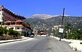 The Syrian town of Kessab, with the peak of Mount Aqra (Turkey) in the background


See also
- Hatay dispute
- Syria–Turkey barrier
- Syria–Turkey relations
- Syrian–Turkish border clashes during the Syrian Civil War
- Syrian Turkmen
- Refugees of the Syrian Civil War
References
- ^ "Türkiyenin Komşuları ve Coğrafi Sınırları". 14 February 2016. Archived from the original on 14 February 2016.
- ^ CIA World Factbook - Syria, 4 April 2020
- ^ The village's population was 583 in 1980 (Türk Dünyası Araştırmaları Vakfı, 1986, p. 142); it was later evacuated due to landslides. A police station and a monument mark the southernmost point of Turkey. Topraktutan forms a small salient into Syrian territory. It corresponds to the Turkish airspace claimed to have been violated prior to the 2015 Russian Sukhoi Su-24 shootdown.
- ^ "Construction interrupted for friendship dam along Turkey-Syria border". Today's Zaman. 29 June 2011. Retrieved 29 April 2012.
- ^ a b c d e f g h International Boundary Study No. 163 Syria-Turkey Boundary (PDF), 7 March 1978, retrieved 4 April 2020
- OCLC 694027.
- OCLC 86068902.
- Encyclopædia Britannica Inc., 15th edn., 1992, Vol. 1, p. 423.
- ^ Treaty of Peace with Turkey signed at Lausanne, Lausanne, Switzerland, 24 July 1923, retrieved 28 November 2012
{{citation}}: CS1 maint: location missing publisher (link) - ^ "Franco-Turkish agreement of Ankara" (PDF) (in French and English). Retrieved 8 August 2014.
- ^ parliament.gov.sy – معلومات عن الجمهورية العربية السورية Archived 2007-06-02 at the Wayback Machine
- ^ "The Alexandretta Dispute", American Journal of International Law
- ^ Lundgren Jörum, Emma: "The Importance of the Unimportant" in Hinnebusch, Raymond & Tür, Özlem: Turkey-Syria Relations: Between Enmity and Amity (Farnham: Ashgate), p 114-122.
- ^ Lundgren Jörum, Emma, Beyond Syria's Borders: A history of territorial disputes in the Middle East, (London & New York: I.B. Tauris), p 108
- ^ "Syria refugees brave mines, machineguns to reach Turkish sanctuary". Reuters. 6 April 2012. "IOM distributes aid to Syrian refugees – Society". KUNA. 6 April 2012. Retrieved 23 February 2013.
- ^ Reuters: "Turkish developer confident Syria wall in place by spring" By Nevzat Devranoglu and Orhan Coskun December 9, 2016
- ^ The Daily Telegraph: "Turkey to build 500-mile wall on Syria border after Isil Suruc bombing" by Nabih Bulos 23 Jul 2015
- ^ "In 72 hours | Number of people killed by Turkish border guards increases to four, as woman shot dead in northern Idlib". www.syriahr.com. April 22, 2021. Archived from the original on 23 April 2021.
- ^ "Turkey / Syria: Border Crossings Status (18 April 2023)". ReliefWeb. UN Office for the Coordination of Humanitarian Affairs. Retrieved 22 February 2025.
Borders of Turkey | |
|---|---|
| |