
Armenia–Turkey border
| Armenia-Turkey border Հայաստան-Թուրքիա սահման Ermenistan-Türkiye sınırı | |
|---|---|
 | |
| Characteristics | |
| Entities | |
| Length | 328 km (204 mi)[1] |

The Armenia–Turkey border (Armenian: Հայաստան–Թուրքիա սահման, romanized: Hayastan–T’urk’ia sahman; Turkish: Ermenistan–Türkiye sınırı) is 311 km (193 m) in length and runs from the tripoint with Georgia in the north to the tripoint with Azerbaijan in the south.[2] The land border has been closed since 3 April 1993.[3] The border is set to reopen for diplomats and citizens of third countries in 2023.[4]
Description
The border starts in the north at the tripoint with Georgia just west of
History

During the 19th century, the Caucasus region was contested between the declining
By the Treaty of San Stefano, ending the Russo-Turkish War (1877–1878), Russia gained considerable land in what is now eastern Turkey (termed Western Armenia), extending the Ottoman-Russian frontier south-westwards.[6][9][10] Russia's gains of Batumi, Kars and Ardahan were confirmed by the Treaty of Berlin (1878), though it was compelled to hand back part of the area around Bayazid (modern Doğubayazıt) and the Eleşkirt valley.[5][6][11]
During the
Seeking to gain independence from both empires, the peoples of the southern Caucasus had declared the
With the Ottoman Empire defeated in Europe and Arabia, the Allied powers planned to partition it via the 1920
In 1920 Russia's Red Army had invaded Azerbaijan and Armenia, ending the independence of both, followed shortly thereafter by Georgia. In order to avoid an all-out Russo-Turkish war the two nations signed the Treaty of Moscow in March 1921, which created a modified Soviet-Ottoman border.[6][20][21][5] However, further fighting took place on the ground and the talks stalled; the treaty's provisions were later confirmed by the Treaty of Kars of October 1921, finalising what is now the Armenia–Turkey border at its current position.[6] The border was then demarcated on the ground in March 1925 – July 1926 by a joint Soviet-Turkish commission.[6][5] Turkey's independence had been recognised by the 1923 Treaty of Lausanne.[22]

Armenia was initially incorporated along with Georgia and Azerbaijan in the
Following the collapse of the USSR in 1991 Armenia gained independence and inherited its section of the Turkey-USSR border. Though Turkey recognised Armenian independence, relations between the two countries almost immediately soured and the border was shut: Turkey opposed irredentist claims to eastern Turkey by Armenian nationalists championing a 'United Armenia', as well as Armenia's efforts to achieve international recognition of the Armenian genocide; Turkey also supported its close ally Azerbaijan in the First Nagorno-Karabakh War.[26] Relations thawed slightly in the 2000s decade, resulting in the signing of the Zurich Protocols in 2009, in which it was envisaged the border could re-open.[27] The talks foundered, however, and the border remains closed.[28][29]
On February 11, 2023, the border was temporarily opened for the first time in 35 years, to let humanitarian aid from Armenia reach victims of a major earthquake in Turkey.[30]
Settlements near the border
Armenia
Turkey
Crossings
There were three crossings along the entire border, two for vehicular traffic and one for vehicular and rail traffic. They have been closed since 3 April 1993.[3]
In July 2022, the Turkish Ministry for Foreign Affairs announced that the two countries, in the context of a general thaw of their relationship, plan to reopen the border "at the earliest possible date", albeit only for third party nationals.[31]
In February 2023, Alican border crossing was opened to allow the passage of humanitarian aid from Armenia to Turkey following the
| Province | Province | Opened | Route in Turkey | Route in Armenia | Status | ||
|---|---|---|---|---|---|---|---|
| Akyaka | Kars | Akhurik | Shirak | 4 September 1953 – 11 July 1993[citation needed] | Closed | ||
| Alican | Iğdır | Margara | Armavir | 1993 | Closed |
Gallery
-
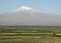 International Armenia–Turkey border near Khor Virap
 -
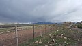
 Border fence near Ani
 -
 The border along the Arkhurian river
 -
 Border fence near Yereruyk
 -
 Destroyed bridge over the Arkhurian river
 -
 Border near Ani
 -
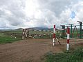
 border near Margara
 -
 Armenian border post


See also
References
- ^ "Türkiyenin Komşuları ve Coğrafi Sınırları". 14 February 2016. Archived from the original on 14 February 2016.
- ^ CIA World Factbook – Turkey, archived from the original on 10 January 2021, retrieved 6 April 2020
- ^ a b "1991'den bugüne Türkiye-Ermenistan ilişkileri: 30 yılda neler yaşandı?". BBC News Türkçe (in Turkish). Retrieved 24 October 2022.
- ^ dpa. "Armenia, Turkey To Partially Reopen Land Border". RadioFreeEurope/RadioLiberty. Retrieved 26 March 2023.
- ^ a b c d e f g h i The boundary between Turkey and the USSR (PDF), January 1952, archived from the original (PDF) on 24 January 2017, retrieved 8 April 2020
- ^ a b c d e f g h i j k International Boundary Study No. 29 – Turkey-USSR Boundary (PDF), 24 February 1964, retrieved 8 April 2020
- ^ John Emerich Edward Dalberg Acton (1907). The Cambridge Modern History. Macmillan & Co. p. 202.
- ISBN 978-1851096725.
The Turks recognize Russian possession of Georgia and the khanates of Yerevan (Erivan) and Nakhchivan that had been ceded by Persia to Russia the year before.
- ^ Hertslet, Edward (1891), "Preliminary Treaty of Peace between Russia and Turkey. Signed at San Stefano 19 February/3 March 1878 (Translation)", The Map of Europe by Treaty; which have taken place since the general peace of 1814. With numerous maps and notes, vol. IV (1875–1891) (First ed.), London: Her Majesty's Stationery Office, pp. 2672–2696, retrieved 4 January 2013
- ^ Holland, Thomas Erskine (1885), "The Preliminary Treaty of Peace, signed at San Stefano, 17 March 1878", The European Concert in the Eastern Question and Other Public Acts, Oxford: Clarendon Press, pp. 335–348, retrieved 4 March 2013
- ^ Holland, Thomas Erskine (1885), "The Preliminary Treaty of Peace, signed at San Stefano, 17 March 1878", The European Concert in the Eastern Question and Other Public Acts, Oxford: Clarendon Press, pp. 305–06, retrieved 4 March 2013
- OCLC 312951712(Armenian Perspective)
- OCLC 78646544(Turkish Perspective)
- ISBN 978-9-004-17901-1
- ISBN 978-1-598-84337-8
- ^ "8 facts about the Armenian genocide 100 years ago". CNN.com. Retrieved 13 December 2015.
- ^ "100 Years Ago, 1.5 Million Armenians Were Systematically Killed. Today, It's Still Not A 'Genocide'". The Huffington Post. 23 April 2015. Retrieved 13 December 2015.
- ISBN 9780814201701.
- ISBN 0-520-08804-2.
- ISBN 978-0300153088.
- ISBN 978-0195177756.
- ^ Treaty of Peace with Turkey signed at Lausanne, Lausanne, Switzerland, 24 July 1923, retrieved 28 November 2012
{{citation}}: CS1 maint: location missing publisher (link) - ISBN 978-0271058597.
- ISBN 978-0253207739.
- ^ Ro'i, Yaacov (1974). From Encroachment to Involvement: A Documentary Study of Soviet Policy in the Middle East, 1945–1973. Transaction Publisher. pp. 106–107.
- ISBN 0-7146-5071-4, p. 273
- ^ "Turkey, Armenia sign deal on normalising relations". The Sofia Echo. 10 October 2009. Retrieved 10 October 2009.
- ISBN 0-7658-0205-8, p. 245
- ^ "The Ties That Divide". Economist. Global Heritage Fund. 15 June 2006. Archived from the original on 5 April 2008. Retrieved 14 August 2008.
- ^ Armenia-Turkey border opened for first time in 35 years to allow aid through, 11 February 2023, retrieved 25 March 2023
- ^ "No: 212, 1 July 2022, Press Release Regarding the Meeting of the Special Representatives for the Normalization Process Between Türkiye and Armenia, Ambassador Serdar Kılıç and Deputy Speaker of the Armenian Parliament Ruben Rubinyan". Retrieved 2 July 2022.
- ^ "Turkey-Syria earthquakes: Death toll passes 24,000". Sözcü. 11 February 2023. Retrieved 14 February 2023.
- ^ "Turkey-Armenia border was opened for humanitarian aid after 35 years". Sözcü. 11 February 2023. Retrieved 11 February 2023.
Borders of Turkey | |
|---|---|