
Transjordan (region)
Transjordan, the East Bank,
The
Name
The prefix trans- is
The
'East of the Jordan'.History
Egyptian period


The Shasu were Semitic-speaking cattle nomads in the Levant from the late Bronze Age to the Early Iron Age. In a 15th-century BCE list of enemies inscribed on column bases at the temple of Soleb built by Amenhotep III, six groups of Shasu are noted; the Shasu of S'rr, the Shasu of Rbn, the Shasu of Sm't, the Shasu of Wrbr, the Shasu of Yhw, and the Shasu of Pysps. Some scholars link the Israelites and the worship of a deity named Yahweh with the Shasu.
The Egyptian geographical term "
Bronze Age collapse
During the
The Transjordanian Hebrew tribes


The
In the
Per the settlement of the Israelite tribes east of the Jordan, Burton MacDonald notes;
There are various traditions behind the Books of Numbers, Deuteronomy, Joshua, Judges, and 1 Chronicles' assignment of tribal territories and towns to Reuben, Gad, and the half-tribe of Manasseh. Some of these traditions provide only an idealized picture of Israelite possessions east of the Jordan; others are no more than vague generalizations. Num 21.21–35, for example, says only that the land the people occupied extended from Wadi Arnon to Wadi Jabbok, the boundary of the Amorites.[9]
Status

There is some ambiguity about the status of the Transjordan in the mind of the biblical writers. Horst Seebass argues that in Numbers "one finds awareness of Transjordan as being holy to
Unlike the other
Lori Rowlett argues that in the Book of Joshua, the Transjordanian tribes function as the inverse of the Gibeonites (mentioned in Joshua 9). Whereas the former have the right ethnicity, but wrong geographical location, the latter have the wrong ethnicity, but are "within the boundary of the 'pure' geographical location."[15]
Other Transjordanian nations
According to
According to both
The Ammonites presented a serious problem to the Pharisees because many marriages with Ammonite (and Moabite) wives had taken place in the days of Nehemiah (Nehemiah 13:23). The men had married women of the various nations without conversion, which made the children not Jewish.[17] The legitimacy of David's claim to royalty was disputed on account of his descent from Ruth, the Moabite.[18] King David spent time in the Transjordan after he had fled from the rebellion of his son Absalom (2 Samuel 17–19).
Classical period


The Decapolis is named from its ten cities enumerated by Pliny the Elder (23–79). What Pliny calls Decapolis, Ptolemy (c. 100–c. 170) calls Cœle-Syria.[19] Ptolemy does not use the term "Transjordan", but rather the periphrasis "across the Jordan".[20] And he enumerates the cities; Cosmas, Libias, Callirhoe, Gazorus, Epicaeros—as being in this district—east of the Jordan, that Josephus et al. called Perea.[21][22][23][24]
Jerash was a prominent central community for the surrounding region during the Neolithic period[25] and was also inhabited during the Bronze Age. Ancient Greek inscriptions from the city, and the literary works of Iamblichus and the Etymologicum Magnum indicate that the city was founded as "Gerasa" by Alexander the Great or his general Perdiccas, for the purpose of settling retired Macedonian soldiers (γῆρας—gēras—means "old age" in Ancient Greek). It was a city of the Decapolis, and is one of the most important and best preserved Ancient Roman cities in the Near East.
The
Bosra is located in a geographical area called the Hauran plateau. The soil of this volcanic plateau made it a fertile region for the cultivation of domesticated cereals during the Neolithic Agricultural Revolution. The city was noted in Egyptian documents of the 14th century BCE, and was situated on the trade routes where caravans brought spices from India and the Far East across the eastern desert while other caravans brought myrrh and frankincense from the south. The region of Hauran then called "Auranitis" came under the control of the Nabataean kingdom. And the city of Bosra then called "Bostra" became the northern capital of the kingdom while its southern capital was Petra. After Pompey's military conquest of Syria, Judaea, and Transjordan. Control of the city was later transferred to Herod the Great and his heirs until 106 CE, when Bosra was incorporated into the new Roman province of Arabia Petraea.
The
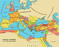
Provincia Arabia Petraea or simply Arabia, was a frontier province of the Roman Empire beginning in the 2nd century. It consisted of the former Nabataean kingdom in the southern Levant, Sinai Peninsula, and northwestern Arabian peninsula.
Crusader period: Oultrejordain
The Lordship of Oultrejordain (Old French for "beyond the Jordan"), also called the Lordship of Montreal, otherwise Transjordan, was part of the Crusader Kingdom of Jerusalem.
Trade routes
- Via Maris
- Via Traiana Nova
- Petra Roman Road
The King's Highway was a trade route of vital importance to the ancient Near East. It began in Egypt and stretched across the Sinai Peninsula to Aqaba. From there it turned northward across Transjordan, leading to Damascus and the Euphrates River. During the Roman period the road was called Via Regia (Orient). Emperor Trajan rebuilt and renamed it Via Traiana Nova (viz. Via Traiana Roma), under which name it served as a military and trade road along the fortified Limes Arabicus.
The
Maps
- BCE
-
 New Kingdom at its maximum territorial extent in the 15th century BCE
 -

-

-
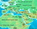
 Near East 1300 BCE
 -
 Near East 1000 BCE
 -

-

-
-


.jpg)
.jpg)


- CE
-
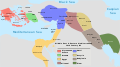
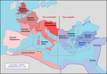
 The British Mandate for Palestine. The Emirate of Transjordan is shown in brown.
 -
-
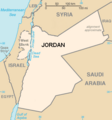
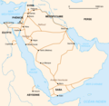
 Countries pictured are (clockwise from top right) Syria, Iraq, Saudi Arabia, Egypt (across the Gulf of Aqaba), Israel, the occupied West Bank Territory, and Lebanon. In the center is Jordan.


- Trade routes
-
 Levantine trade routes 1300 BCE
 -
-


- Egyptian Empire
-
-
-
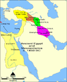
 The Hanigalbat (Mitanni) and Egypt.
 -

-

-
 Map of the Ancient Near East during the Amarna Period.
 -
-
-


- Transjordan Kingdoms 830 BCE
-

-
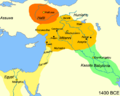
 Transjordan Kingdoms during the Iron Age 830 BCE
 -


- Roman Orient


- Roman Empire
-
-
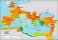
 Network of primary Roman roads in the reign of Hadrian
 -
-


See also
- The East Bank of the Jordan
- Emirate of Transjordan
- Geography of Jordan
- Gilead
- Oultrejordain
- Perea (region)
- Transjordan in the Bible, an area of land in the Southern Levant lying east of the Jordan River that is mentioned in the Hebrew Bible
- Transjordan memorandum
References
- S2CID 150542926.
- ^ "Joshua 1:15". Hebrew Bible. Trowitzsch. 1892. p. 155.
- ^ "Joshua 1:15". The Septuagint Version of the Old Testament, with an English translation; and with various readings and critical notes. Gr. & Eng. S. Bagster & Sons. 1870. p. 281.
- ^ Merrill, Selah (1881). East of the Jordan: A Record of Travel and Observation in the Countries of Moab, Gilead and Bashan. C. Scribner's sons. p. 444.
Image of p. 444 at Google Books
{{cite book}}: External link in|quote= - ISBN 978-87-7289-421-8.
- ISBN 978-0-19-150502-7.
Damascus' history extends well back before the Aramaean occupation. It is first attested as one of the cities and kingdoms which fought against and were defeated by the pharaoh Tuthmosis III at the battle of Megiddo during Tuthmosis' first Asiatic campaign in 1479 (ANET 234-8). Henceforth, it appears in Late Bronze Age texts as the centre of a region called Aba/Apa/Apina/Upi/Upu [Apu]. From Tuthmosis' conquest onwards, for the remainder of the Late Bronze Age, this region remained under Egyptian sovereignty, though for a short time after the battle of Qadesh, fought in 1274 by the pharaoh Ramesses 11 against the Hittite king Muwatalli II, it came under Hittite control. After the Hittite withdrawal, Damascus and its surrounding region marked part of Egypt's northern frontier with the Hittites.
- ^ David Jobling, The Sense of Biblical Narrative II: Structural Analyses in the Hebrew Bible (JSOTSup. 39; Sheffield: Sheffield Academic Press, 1986) 116.
- ^ Elie Assis, "For it shall be a witness between us: a literary reading of Josh 22," Scandinavian Journal of the Old Testament 18 (2004) 216.
- American Schools of Oriental Research. p. 149. Archived from the original(PDF) on 2014-06-01. Retrieved 2016-10-20.
- ^ a b Moshe Weinfeld, The Promise of the Land: The Inheritance of the Land of Canaan by the Israelites (Berkeley: University of California Press, 1993), 54.
- ^ Horst Seebass, "Holy Land in the Old Testament: Numbers and Joshua," Vetus Testamentum 56 (2006) 104.
- Richard S. Hess, "Tribes of Israel and Land Allotments/Borders," in Bill T. Arnold and H. G. M. Williamson (eds.), Dictionary of the Old Testament Historical Books (Downers Grove: IVP, 2005), 970.
- ^ Moshe Weinfeld, "The Extent of the Promised Land – the Status of Transjordan," in Das Land Israel in biblischer Zeit (ed. G. Strecker; Göttingen: Vandenhoeck & Ruprecht, 1983) 66-68.
- ^ Jacob Milgrom, Numbers (JPS Torah Commentary; Philadelphia: JPS, 1990), 74.
- ^ Lori Rowlett, "Inclusion, Exclusion and Marginality in the Book of Joshua," JSOT 55 (1992) 17.
- Jewish Encyclopedia. 1906. Retrieved 2014-08-10.
- ^ The identity of those particular tribes had been lost during the mixing of the nations caused by the conquests of Assyria. As a result, people from those nations were treated as complete gentiles and could convert without restriction.[citation needed]
- ^ The Babylonian Talmud points out that Doeg the Edomite was the source of this dispute. He claimed that since David was descended from someone who was not allowed to marry into the community, his male ancestors were no longer part of the tribe of Judah (which was the tribe the King had to belong to). As a result, he could neither be the king, nor could he marry any Jewish woman (since he descended from a Moabite convert). The Prophet Samuel wrote the Book of Ruth in order to remind the people of the original law that women from Moab and Ammon were allowed to convert and marry into the Jewish people immediately.[citation needed]
- ^ Hodgson, James; Derham, William; Mead, Richard; M. de Fontenelle (Bernard Le Bovier) (1727). Miscellanea Curiosa: Containing a Collection of Some of the Principal Phænomena in Nature, Accounted for by the Greatest Philosophers of this Age: Being the Most Valuable Discourses, Read and Delivered to the Royal Society, for the Advancement of Physical and Mathematical Knowledge. As Also a Collection of Curious Travels, Voyages, Antiquities, and Natural Histories of Countries; Presented to the Same Society. To which is Added, A Discourse of the Influence of the Sun and Moon on Human Bodies, &c. W. B. pp. 175–176.
Decapolis was so called from its ten Cities enumerated by Pliny (lib. 5. 18.) And with them he reckons up among others, the Tetrarchy of Abila in the same Decapolis : Which demonstrates the Abila Decapolis and Abila Lysaniæ to be the same Place. And tho'it cannot be denied, but that some of Pliny's ten Cities are not far distant from that near Jordan ; yet it doth not appear that ever this other had the Title of a Tetrarchy. Here it is to be observed, that what Pliny calls Decapolis, Ptolemy makes his Cœle-Syria ; and the Cœle-Syria of Pliny, is that Part of Syria about Aleppo, formerly call'd Chalcidene, Cyrrhistice, &c. (Image of p. 175 & p. 176 at Google Books)
{{cite book}}: External link in|quote= - ^ Smith, William (1873). A Dictionary of Greek and Roman Geography. J. Murray. p. 533.
[Ptolemy] describes the Peraea by a periphrasis as the eastern side of Jordan which may imply that the name [Peraea] was no longer in vogue. (Image of p. 533 at Google Books)
{{cite book}}: External link in|quote= - ^ Ptolemy, Geographica, Book 5, Ch.15:6
- ISBN 978-0-19-870974-9.
Ptolemy's Geographica provided a great compendium of knowledge in terms of the placements of cities and lands in the ancient world, information that would form the basis of medieval cartography, resulting in a standard Ptolemaic map of Asia, including Palestine. The information about Judaea appears in Book 5, where pars Asphatitem lacum are mentioned as well as the main cities. In the region east of the Jordan, there are sites that are not all easy to determine: Cosmas, Libias, Callirhoe, Gazorus, Epicaeros (Ptolemy, Geogr. 5: 15: 6).
- ISBN 978-1-59244-748-0.
Ptolemy's divisions of Palestine (v. xv) appear to follow popular lines. They are Galilee, Samaria, Judaea (with a subdivision 'across the Jordan'), and Idumaea. These divisions were also for the most part, as Josephus' survey of Palestine (Bell., III. iii. 1-5, §§ 35-57) shows, official. Josephus, however, does not recognize Idumaea, merging it in Iudaea, and definitely distinguishes Peraea from Judaea. Had Ptolemy derived his divisions from an official source, he would probably have followed this scheme, and in particular would have used the official term Peraea instead of the periphrasis 'across the Jordan'.
- ISBN 978-0-520-93102-2.
The problem of indicating precise ancient boundaries in Transjordan is difficult and complex and varies according to the time period under discussion. After the creation of the Roman province of Arabia in 106 A.D. Gerasa and Philadelphia were included in it. Nonetheless, Ptolemy—who was writing in the second century A.D. but did not record places by Roman provinces—described them as being in (the local geographical unit of) Coele Syria (5.14.18). Furthermore, Philadelphia continued to describe itself on its coins and in inscriptions of the second and third centuries A.D. as being a city of Coele Syria; see above, Philadelphia, n. 9. As for the boundaries of the new province, the northern frontier extended to a little beyond the north of Bostra and east; the western border ran somewhat east of the Jordan River valley and the Dead Sea but west of the city of Madaba (see M. Sartre, Trois ét., 17-75; Bowersock, ZPE5, [1970] 37-39; id., JRS61 [1971] 236-42; and especially id.. Arabia, 90-109). Gadara in Peraea is identified today with es-Salt near Tell Jadur, a place that is near the western boundary of the province of Arabia. And this region could have been described by Stephanos as being located "between Coele Syria and Arabia."
- ^ Dana Al Emam (15 August 2015). "Two human skulls dating back to Neolithic period unearthed in Jerash". The Jordan Times. Retrieved 4 July 2016.
External links