
Vikos–Aoös National Park
| Vikos-Aoös National Park | |
|---|---|
Greek Ministry of Agriculture) | |
 |
The Vikos–Aoös National Park (
The core of the park, an area of 3,400 hectares (8,402 acres),
The first evidence of human presence in the area is dated between 17,000 and 10,000 years ago. The area of the park has been sparsely populated throughout historical times, however from the 17th to the 19th century the local communities of
Geography and geology
Vikos Gorge

The Vikos Gorge is located on the southern slopes of
The Vikos Gorge has been carved over millions of years by the
As the Vikos Gorge is a deep cross section of the mountain, its slopes expose a series of rock formations of various ages. The upper layers, at a depth of 0–200 m (660 ft), consist of relatively young
A special feature of the limestone, resulting from its weathering by water, is its
Aoös Gorge
In the northern part of the Park, and very close to the town of
Mt Tymphe

Between the two gorges lies the
A number of
Settlements
There are four villages inside the Vikos–Aoös National Park, and an additional nine near the borders of the peripheral zone. All of these settlements, in the western part of the Zagori region, are sparsely populated with a total population of 1,515 people.[29] The villages have a nucleus-like form, with the houses situated around the central square and interconnected by pathways paved by slate or cobblestone.[30] Historically, all the villages of the Zagori region were connected by a system of paths or small roads and they functioned more like a single entity rather than as separate communities.[31]
The economic affluence of Zagori's past is still reflected in the architecture of the villages,[7] while today the preservation of the local architectural legacy is enshrined in a law which dictates that all buildings in the area must be constructed with local traditional materials and in compliance with local architecture. One of the characteristic features of the National Park is its stone bridges, which were the only connection to the outside world until roads were built in the 1950s.[32] Sixteen of these stone bridges and seven churches in the region have been listed as protected historical monuments.[33]
Climate
The climate of the Vikos–Aoös National Park is
| Climate data for Vikos–Aoös National Park | |||||||||||||
|---|---|---|---|---|---|---|---|---|---|---|---|---|---|
| Month | Jan | Feb | Mar | Apr | May | Jun | Jul | Aug | Sep | Oct | Nov | Dec | Year |
| Daily mean °C (°F) | 3.7 (38.7) |
4.0 (39.2) |
6.1 (43.0) |
9.0 (48.2) |
15.4 (59.7) |
18.7 (65.7) |
22.0 (71.6) |
21.1 (70.0) |
18.1 (64.6) |
12.3 (54.1) |
7.8 (46.0) |
4.5 (40.1) |
11.9 (53.4) |
| Average precipitation mm (inches) | 110.4 (4.35) |
108.3 (4.26) |
89.4 (3.52) |
108.9 (4.29) |
68.8 (2.71) |
52.4 (2.06) |
36.9 (1.45) |
36.7 (1.44) |
60.1 (2.37) |
128.8 (5.07) |
156.8 (6.17) |
143.4 (5.65) |
1,100.9 (43.34) |
| Source: [36] | |||||||||||||
Wildlife

The park's varied geology and topography have resulted in a unique variety of
Flora
The forests are composed of diverse species of
Studies on the non-vascular flora recorded the presence of about 150
Fauna

The Vikos–Aoös National Park preserves one of the richest mountain and forest ecosystems in terms of wildlife diversity in Greece.
A total of 121 bird species have been observed in the park, with twenty-six of them being considered of conservation priority. The area hosts fifteen

The Vikos-Aoös area also contains a variety of suitable habitats that support dense populations of amphibians and reptiles.
Human history

The first evidence of human presence in the area is dated to between 17,000 and 10,000 years ago. During this period, favorable climatic conditions prevailed that permitted the hunting of the
In the era of Ottoman rule, and especially from the 17th to the 19th century, the local
The area is nowadays sparsely populated as the result of urbanization after World War II. Many of the dwellings now remain shut, while abandonment of the traditional rural economy has affected the cultural landscape.[10] Epirus, of which Vikos–Aoös is part, is considered one of the most underdeveloped regions in Greece. Tourism constitutes the principal source of revenue for the local economy, although it has a highly seasonal character. Intense development in terms of accommodation and tourism infrastructure occurred in the 1980s, mainly through state initiatives.[57]
Park management

The Vikos–Aoös area was designated as a
The administration and management of the Vikos–Aoös National Park belongs to two district forest offices, supervised by a forest directorate at the prefecture level. Moreover, the office of

The vast area of the National Park and the present lack of road infrastructure make remote sensing the only means for monitoring the human activities in the area and their impact on the ecosystem. An analysis has begun by taking a detailed picture of the territory covering at least the following items: orography and slopes, road networks, land cover and use, human settlements, and tourist sites. The use of remote sensing and geographic information system techniques is of essential value for the park's management and constitutes the basis for further evaluations and impact analysis.[58]
The objective of the present state and regional policy is to carefully combine tourism development in the area with the preservation of its natural and cultural heritage. Ecotourism poses an ideal solution, since it has the potential of bringing about the desired balance between socio-economic development and environmental protection.[57] Specific objectives of ecotourism development include reviving traditional activities such as small-scale farming and stock-raising,[59] as well as establishing a network of communities of chamois biotopes.[60]
Recreation

The Vikos–Aoös National Park is a natural tourist attraction, with high ecotourism and
The rivers in the Vikos–Aoös area are a destination for
Gallery
-
 Astraka peak (known as 'Astraka towers') over the village Mikro Papingo
 -
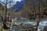
 The Voidomatis river with Astraka peak in the background
 -
 Platanus orientalis tree on the bank of the Voidomatis
 -
 Landscape in Vikos–Aoös National Park.
 -
 Landscape in Vikos–Aoös National Park.
 -
 Landscape in Vikos–Aoös National Park.
 -
 Landscape in Vikos–Aoös National Park.
 -
 Landscape in Vikos–Aoös National Park.
 -
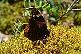 Butterfly in Vikos–Aoös National Park.


See also
References
- ^ a b c d e Trakolis 2001, p. 3
- ^ a b Papadopoulou 2008, p. 20
- ^ Spanopoulou 2001, p. 16
- ^ a b c Natura 2000, p. 8
- ^ a b c d Amanatidou 2005, p. 28
- ^ Papageorgiou 2001, p. 3
- ^ a b c Vokou, Katradia, Kokkini 1993, p. 1
- ^ a b Amanatidou 2005, p. 41
- ^ a b c d Amanatidou 2005, p. 21
- ^ a b Amanatidou 2005, p. 17
- ^ a b c Hanlidou, Kokkini 1997, p. 2
- ^ "Northern Greece: The Pindhos Mountains: A Greentours Natural History Holiday" (PDF). greentours.co.uk. p. 2. Archived from the original (PDF) on 2012-03-10. Retrieved 2010-08-10.
- ^ ISBN 978-1-74104-656-4.
- ^ Natura 2000, p. 10
- ^ a b c Amanatidou p. 32
- ^ Woodward, Hamlin, Macklin, Hughes, Lewin 2008, p. 64
- ^ a b Woodward, Hamlin, Macklin, Hughes, Lewin 2008, p. 49
- ^ a b Amanatidou 2005, pp. 21–22
- ^ Woodward, Hamlin, Macklin, Hughes, Lewin 2008, p. 63
- ^ Papadopoulou 2008, p. 12, 18, 20
- ^ Paschos, Nikolaou, Papanikos 2004, p. 18
- ^ Paschos, Nikolaou, Papanikos 2004, p. 7
- ^ a b Paschos, Nikolaou, Papanikos 2004, p. 15
- ^ .
- ^ Paschos, Nikolaou, Papanikos 2004, p. 16
- ^ Hughes, Gibbard, Woodward 2003, p. 2
- ^ Woodward, Hamlin, Macklin, Hughes, Lewin 2008, p. 8
- ^ Hughes, Gibbard, Woodward 2003, p. 3
- ^ a b Trakolis 2001, pp. 2–3
- ^ Amanatidou 2005, p. 36
- ^ Vokou, Katradia, Kokkini 1993, p. 8
- ^ Drakopoulou 2004, p. 27
- ^ Spanopoulou 2001, p. 17
- ^ a b Amanatidou 2005, pp. 23–24
- ^ Paschos, Nikolaou, Papanikos 2004, p. 5
- ^ a b "Papingo meteorological station, 1971-1990 climatic data". Hellenic National Meteorological Service. Archived from the original on 2010-11-23. Retrieved 2010-11-13.
- ^ Amanatidou 2005, pp. 29–31
- ^ Amanatidou 2005, p. 27
- ^ Amanatidou 2005, p. 84
- ^ Amanatidou 2005, p. 80
- ^ Vokou, Katradia, Kokkini 1993, p. 10
- ^ a b Hanlidou, Kokkini 1997, p. 1
- ^ Vokou, Katradia, Kokkini 1993, p. 1,8
- ^ Vokou, Katradia, Kokkini 1993, pp. 3–8
- ISBN 978-1-86011-898-2.
- ^ a b c Amanatidou 2005, p. 29
- ^ a b c Natura 2000: p. 9
- ^ Drakopoulou 2004, p. 26
- ^ Amanatidou 2005, p. 31
- ISBN 978-1-84330-261-2.
- ^ Papadopoulou 2008, p. 15
- JSTOR 25800523.
- ^ Papadopoulou 2008, p. 14
- ^ a b Amanatidou 2005, p. 34
- ISBN 978-960-213-371-2.
- ISBN 978-1-900639-35-4.
- ^ a b c d Drakopoulou 2004, p. 28
- ^ ]
- ^ Drakopoulou 2004, p. 29
- ^ Drakopoulou 2004, p. 31
- ^ a b Trakolis 2001, p. 11
- ^ Paschos, Nikolaou, Papanikos 2004, p. 9
Sources
- Amanatidou, Despoina (2005). "A case study in Vikos-Aoos National Park - Greece" (PDF). University of Freiburg. Retrieved 2009-07-27.
- Drakopoulou, Athanasia (2004). "Tourism Certification and Community-based Ecotourism as Tools for Promoting Sustainability in the Greek Tourism Sector - the example of Zagori" (PDF). Lund University. Archived from the original (PDF) on 2011-10-08. Retrieved 2009-06-23.
- Hanlidou, Efie; Kokkini, Stella (1997). "On the flora of the Vikos-Aoos National Park (NW Greece)" (PDF). Willdenowia. 27 (1–2): 81–100. ISSN 0511-9618. Retrieved 2013-10-16.
- Hughes, P.D.; Gibbard, P.L.; Woodward, J.C. (2003). "Relict rock glaciers as indicators of Mediterranean palaeoclimate during the Last Glacial Maximum (Late Wurmian) in northwest Greece" (PDF). Journal of Quaternary Science. 18 (5): 431–440. doi:10.1002/jqs.764.
- "Natura 2000 Data Form. Site code: GR2130009" (PDF). NATURA 2000. Greek Ministry for the Environment, Physical Planning & Public Works. 2009. Archived from the original(PDF) on 2011-07-16. Retrieved 2010-07-12.
- Papadopoulou, Varvara (2008). "Prefecture of Ioannina, Epirus-Greece" (PDF). Prefectural Committee of Tourist Promotion. Archived from the original (PDF) on 2011-07-19. Retrieved 2009-11-02.
- Papageorgiou, Konstantinos (2001). "A Combined Park Management Framework Based on Regulatory and Behavioral Strategies: Use of Visitors' Knowledge to Assess Effectiveness". Environmental Management. 28 (1): 61–73. PMID 11437001.
- Paschos, P.; Nikolaou, E.; Papanikos, D. (2004). Explore the landscape, the rocks and the nature of Vikos-Aoos and surrounding area. Find out its history and civilisation (PDF). Greek Institute of Geology & Mineral Exploration. ISBN 978-960-98903-5-9. Archived from the original(PDF) on 2011-07-21. Retrieved 2010-08-06.
- Spanopoulou, Kyriaki (2001). "Integrated Programmes for Development of Mountain Regions: The Case of the Tymfi area" (PDF). Directorate for Planning and Evaluation of Regional Policy and Programmes, Republic of Greece, Ministry of National Economy. Archived from the original (PDF) on 2012-10-24. Retrieved 2009-07-09.
- Trakolis, Dimitrios (2001). "Perceptions, Preferences, and Reactions of Local Inhabitants in Vikos-Aoos National Park, Greece". National Agricultural Research Foundation. 28 (5): 665–76. PMID 11568846.
- Vokou, Despina; Katradia, Katerina; Kokkini, Stella (1993). "Ethnobotanical survey of Zagori (Epirus, Greece), a renowned center of folk medicine in the past". Journal of Ethnopharmacology. 39 (3): 187–196. PMID 8258976.
- Woodward, J.C.; Hamlin, R.H.B.; Macklin, M.G.; Hughes, P.D.; Lewin, J. (2008). "Glacial activity and catchment dynamics in northwest Greece: Long-term river behaviour and the slackwater sediment record for the last glacial to interglacial transition". Geomorphology. 101 (1–2): 44–67. .
Further reading
- Hanlidou, E.; Kokkalou, E.; Kokkini, S. (1999). "Distribution of taxa with alkaloids and/or related compounds in Vikos-Aoos National Park (NW Greece)" (PDF). Nordic Journal of Botany. 19 (1): 61–73. ]
- Kanellopoulos, Nikos. "Photographic Journey in Greece: Mt Gamila photos". diafragma.gr. Retrieved 2010-08-10.
- Petrakis, Mike; Psiloglou, Basil; Keramitsoglou, Iphigenia. "The Mountain Park of Vikos-Aoos, N. Greece" (PDF). Park Resources Information Management Via Environmental Remotely sensed data Analysis. Retrieved 2009-06-09.
- "Sustainable Management and Development of Mountainous and Island Areas" (PDF). Department of Forestry and Management of the Environment and Natural Resources. Democritus University of Thrace. p. 38. Archived from the original (PDF) on 2011-07-21. Retrieved 2009-07-21.
- Zissis, Costas (2006). Zagori, Images of a Greek Heritage. ISBN 978-960-631-684-5.
External links
| National (Woodland) Parks | ||
|---|---|---|
| National Marine Parks | ||
| National Parks |
| |
| International | |
|---|---|
| National | |