Source: Wikipedia, the free encyclopedia.
Place in Gauteng, South Africa
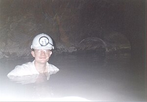 Flooded level, West Driefontein mine, South Africa. The dolomite overlying the gold reefs hosts much groundwater, giving the mines flooding problems.
West Driefontein was a South African gold mining company belonging to the Goldfields Group (now Sibanye Gold).
It lies approximately 10 kilometres (6.2 mi) outside
. It used to be the richest gold mine in the world before it was flooded by water.
References
|
|---|
|
|
Cityscape |
|---|
| Landmarks | | Public art |
|
|---|
Civic
buildings | |
|---|
Office
buildings |
|
|---|
Residential
buildings |
|
|---|
| Structures | |
|---|
|
|---|
| Urban planning | |
|---|
|
|
|
Politics |
|---|
| Governing parties | |
|---|
Political organisations
and parties based in
Greater Johannesburg | | Political parties | |
|---|
| Trade unions | |
|---|
Other political
organisations | |
|---|
|
|---|
|
|
|
|---|
| Fortifications | |
|---|
Monuments
and memorials | |
|---|
| Cemeteries | |
|---|
Historical
sites |
|
|---|
Historical
companies and
organisations | | Companies | |
|---|
Political
organisations | |
|---|
| Other organisations | |
|---|
|
|---|
| Events | |
|---|
|
|
|
|---|
| Cultural heritage | |
|---|
| Performance art | | Musical ensembles | |
|---|
| Theatres | |
|---|
|
|---|
| Events and festivals | |
|---|
Museums and art
galleries |
|
|---|
| Clubs and societies | |
|---|
|
|
|
|---|
- SACC
- Anglican
- Catholic
- Protestant
- Jewish
- Islamic
Places of
worship | | Churches | |
|---|
| Synagogues | |
|---|
| Mosques | |
|---|
| Hindu temples | |
|---|
| Scientology centres | |
|---|
|
|---|
|
|
|
|---|
| Mass media | | Magazines |
|
|---|
| Newspapers |
|
|---|
| Radio stations | |
|---|
| Television channels |
|
|---|
| Film studios |
|
|---|
| Record labels | |
|---|
| Game studios | |
|---|
|
|---|
| Cultural references | |
|---|
|
|
|
|---|
| Companies | |
|---|
Diversified
conglomerates | |
|---|
| Airlines |
|
|---|
Construction
and engineering | |
|---|
| Energy | |
|---|
Financial
|
|
|---|
| Hospitality | |
|---|
| ICT | |
|---|
| Legal | |
|---|
| Manufacturing | |
|---|
| Media | |
|---|
| Mining | |
|---|
Retail and
marketing | |
|---|
Restaurant
franchises | |
|---|
| Services | |
|---|
| Transport | |
|---|
State-owned
enterprises | |
|---|
|
|
|---|
Professional
associations | |
|---|
| Mining |
|
|---|
| Shopping centres | |
|---|
| Hotels and resorts | |
|---|
| Venues | |
|---|
Restaurants,
bars and cafés | |
|---|
| Tourism |
|
|---|
|
|
|
|
|---|
Sports governing
bodies based in
Greater Johannesburg | |
|---|
| Teams | | Soccer |
|
|---|
| Rugby | |
|---|
| Cricket | |
|---|
| Basketball | |
|---|
|
|---|
| Equestrian sports | |
|---|
| Sports events | |
|---|
| Sports venues | Stadia and
arenas |
|
|---|
| Golf courses | |
|---|
Equestrian
venues | |
|---|
Motorsports
venues |
|
|---|
|
|---|
|
|
|
|---|
| Libraries | |
|---|
| Universities | |
|---|
Other tertiary
institutions | | Business schools | |
|---|
| Religious institutions | |
|---|
|
|---|
| State schools | |
|---|
| Private schools | |
|---|
| Alternative schools | |
|---|
| International schools | |
|---|
|
|
Services |
|---|
| Hospitals |
|
|---|
Water supply
and sanitation |
|
|---|
| Electricity supply |
|
|---|
Law enforcement and
emergency services | |
|---|
| Charities and NGOs | |
|---|
|
|
Military units and formations |
|---|
|
|
|


.svg)