
A18 road (England)
This article needs additional citations for verification. (January 2017) |
 | ||
|---|---|---|
A638 in DoncasterA1077 in Gunness A159 in Scunthorpe A15 in Broughton A1173 in Riby | ||
| Location | ||
| Country | Primary destinations Scunthorpe | |
| Road network | ||
| ||
The A18 is a road in England that links Doncaster in South Yorkshire with Ludborough in Lincolnshire, via Scunthorpe and Grimsby. Much of its route has been superseded by the M180 motorway.
Route
Doncaster – M180
The A18 begins as a dual-carriageway and trunk road at the Balby Flyover junction with the
The road enters Dunsville as High Street and becomes Doncaster Road. In Hatfield, it becomes Manor Road and then High Street, and crosses the
M180 – Brigg
As High Levels Bank, it crosses a flat landscape known as
The road enters the Queensway Roundabout for the trunk road
Brigg – Ludborough
At Scawby Brook, there is a roundabout with the B1206 (for Scawby), and the road enters Brigg to the left as Scawby Road, becoming Bridge Street and then Ancholme Way. The B1206 (former A15) leaves to the left and the road enters Wrawby as Brigg Road and becomes Melton Road.
The road passes through
The road meets the A46 Grimsby road, and heads straight on over the roundabout. The A18 used to continue eastwards from here along the present A46 into Grimsby, and now continues southwards over Welbeck Hill along the former B1431. The boundary of Lincolnshire and North East Lincolnshire runs down the middle of the road for about 3 miles (4.8 km). The road re-enters Lincolnshire and the district of East Lindsey. The road follows the former A16 from Ludborough to near Utterby, where is meets the A16 (for Louth).
The last section, between the junction with the A46 at Laceby and the junction with the A16 at Ludborough, was designated by the Road Safety Foundation as the most dangerous in the country for car drivers, drawing on collated data on the number of fatal and serious-injury collisions in 2010.[2] During a 2015 inquest, a coroner called for an independent review of the A18 near Grimsby; the coroner was reacting to the death of a family after a collision with a lorry.[3] In 2016, the government announced that £175 million would be made available for safety improvements on roads like the A18.[4]
Gallery
-
 Leger Way in Doncaster next to Doncaster Racecourse
 -
 Tudworth Roundabout with the A614 and M180 – former A18(M)
 -

-
 Crossing the M180 near Castlethorpe between Scunthorpe and Brigg
 -
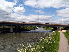 A18 in Brigg over the River Ancholme
 -
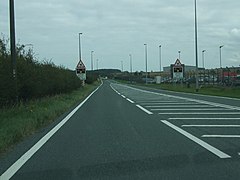 Passing Humberside Airport
 -
 Approaching Laceby on one of the few dual carriageway sections on the Barton Street Roman road


A18(M) motorway
A18(M) | |
|---|---|
| Location | Hatfield, South Yorkshire |
| Length | 1.0 mi (1.6 km) |
| Existed | 1972–1978 |
The A18(M) was a short
The western end of the M180 from M18 junction 5 to the junction 1 eastbound
Junction list
This article may be confusing or unclear to readers. In particular, difficult to understand the differing destinations for each carriage way. (March 2023) |
| County | Location | mi[1] | km | Destinations | Notes |
|---|---|---|---|---|---|
| Western terminus | |||||
| 0.4 | 0.64 | To A1 and The North signed eastbound only; western terminus of A638 concurrency; northern terminus of A6182 | |||
| 1.4 | 2.3 | A638 east / Bennetthorpe (Bawtry Road) – Bawtry, Doncaster town centre, Rossington, Cantley, Robin Hood Airport | Robin Hood Airport signed westbound only; eastern terminus of A638 concurrency | ||
| 3.9 | 6.3 | Doncaster town centre signed westbound only; western terminus of A630 concurrency | |||
| To M180 and M62 signed eastbound only; eastern terminus of A630 concurrency | |||||
A1146 north (Thorne Road) | Southern terminus of A1146 | ||||
| 9.5 | 15.3 | A614 south (Stone Hill) – Bawtry, Robin Hood Airport | Western terminus of A614 concurrency | ||
| 10.3 | 16.6 | ||||
A614 north (Tudworth Road) – Thorne | Eastern terminus of A614 concurrency | ||||
| Keadby–Gunness boundary | 20.8– 20.9 | 33.5– 33.6 | Keadby Bridge over River Trent | ||
| To B1216 and destinations signed eastbound only | |||||
| Northern terminus of A159 | |||||
| 26.6 | 42.8 | Southern terminus of A1029 | |||
| North-western terminus of A1084 | |||||
| Brief concurrency | |||||
| Eastern terminus | |||||
1.000 mi = 1.609 km; 1.000 km = 0.621 mi
| |||||
References
- ^ a b "Doncaster, UK to Hatfield, Doncaster, UK to 47 Glanville Ave, Scunthorpe DN17 1DB, UK to Brigg, UK to Lincoln Gate, Grimsby, UK to A16, Louth LN11 0TP, UK". Google Maps. Alphabet Inc. Retrieved 30 March 2023.
- ^ Clark, Eric (1 July 2010). "Hidden dangers of Britain's deadliest roads". The Telegraph. Retrieved 17 July 2015.
- ^ "Coroner calls for "killer" A18 road review". BBC News. 8 March 2016. Retrieved 29 August 2017.
- ^ "£175m to tackle 50 killer roads, under £1.3bn plans - The Transport Network". www.transport-network.co.uk. Retrieved 29 August 2017.
External links
| Great Britain | .svg) | |||||||||||||||||||
|---|---|---|---|---|---|---|---|---|---|---|---|---|---|---|---|---|---|---|---|---|
| Northern Ireland | ||||||||||||||||||||
| Former | ||||||||||||||||||||
| Unbuilt | ||||||||||||||||||||
| Junctions ( | ||||||||||||||||||||
| Bridges | ||||||||||||||||||||
| Related articles | ||||||||||||||||||||
A roads in Zone 1 of the Great Britain road numbering scheme | ||
|---|---|---|