
Camino Real de Tierra Adentro
| Camino Real de Tierra Adentro | |
|---|---|
 Map of El Camino Real de Tierra Adentro | |
| Location | Mexico and the United States |
| Governing body |
|
| Website | El Camino Real de Tierra Adentro National Historic Trail |
| Location | Mexico |
| Criteria | Cultural: (ii), (iv) |
| Reference | 1351 |
| Inscription | 6969 (4991st Session) |
| Area | 3,101.91 ha (7,665.0 acres) |
| Buffer zone | 268,057.2 ha (662,384 acres) |
The Camino Real de Tierra Adentro (English: Royal Road of the Interior Land), also known as the Silver Route,
In 2010, 55 sites and five existing
The 404-mile (650 km) section of the route within the
Route
The road is identified as beginning at the Plaza Santo Domingo very close to the present Zócalo and Mexico City Metropolitan Cathedral in Mexico City.[5] Traveling north through San Miguel de Allende, Guanajuato, the road's northern terminus is located at Ohkay Owingeh, New Mexico.
History


Pre-Columbian
Long before Europeans arrived, the various indigenous tribes and kingdoms that had arisen throughout the northern central steppe of Mexico had established the route that would later become the Camino Real de Tierra Adentro as a major thoroughfare for hunting and trading. The route connected the peoples of the Valley of Mexico with those of the north through the exchange of products such as turquoise, obsidian, salt and feathers. By the year AD 1000, a flourishing trade network existed from Mesoamerica to the Rocky Mountains.[6]
European incursion
After
In April 1598, a group of military scouts led by
After the
, and northern ranchos. The conducta consisted of wagon caravans that departed every three years from Mexico City to Santa Fe along the Camino Real de Tierra Adentro. The trip required a long and difficult journey of six months, including 2–3 weeks of rest along the way.Many were the uncertainties that the conducta and other travelers faced. River floods could force weeks of waiting on the banks until the caravan could wade across. At other times, prolonged droughts in the area could make water scarce and difficult to find. The most feared section of the journey was the crossing of the Jornada del Muerto beyond El Paso del Norte: nearly 100 kilometres (62 mi) of expansive, barren desert without any water sources to hydrate the men and beasts.
Beyond the sustenance needs, the greatest danger to the caravan was that of local assaults. Groups of bandits roamed throughout the territory and threatened the caravan from the current state of Mexico to the state of Querétaro, seeking articles of value. And from the southern part of Zacatecas onward to the north, the greatest threat was the native Chichimecas, who became more likely to attack as the caravan progressed further north. The main objective of the Chichimecas was horses, but they would also often take women and children. A series of presidios along the way allowed for relays of troops to provide additional protection to the caravans. At night in the most dangerous areas, the caravans would form a circle with their wagons with the people and animals inside.


The Camino Real was actively used as a commercial route for more than 300 years, from the middle of the 16th century to the 19th century, mainly for the transport of silver extracted from northern mines. During this time, the road was continuously improved, and over time the risks became smaller as haciendas and population centers emerged.
18th century
During the 18th century, the sites along the Camino Real de Tierra Adentro increased significantly. The area between the villas of
The villa of San Felipe Neri de Alburquerque (present-day Albuquerque, New Mexico) was founded in 1706 and it also became an important terminal. Because of its defensive position on the Camino Real, the Villa de Alburquerque became the center of commercial exchange between Nuevo México and the rest of New Spain during the 18th century, trading cattle, wool, textiles, animal skins, salt, and nuts. This exchange occurred mainly with the mining cities of Chihuahua, Santa Bárbara, and Parral.
El Paso del Norte (present-day Ciudad Juárez) became another major terminal on the route. In 1765, the population of El Paso del Norte was estimated to be 2,635 inhabitants, which created what was then the largest urban center on the northern border of New Spain. El Paso del Norte became an important center of agriculture and rancheria, known for its wines, brandy, vinegar, and raisins.
In the 18th century, the
For the second half of the 18th century, the northern frontier of New Spain represented a fundamental interest for the Spanish Empire and its reformist policy, with the aim of ensuring Spanish sovereignty over its northern provinces, highly coveted geopolitically by other European powers – especially the English and the French.[8] The Spanish Crown labored to incorporate the natives into the social and economic welfare of its provinces and give them reasons to participate in the defense of the Spanish border.[8]
Thus, Captain
In 1786, the nephew of José de Gálvez, Bernardo de Gálvez, viceroy of New Spain published his "Instructions" which included three strategies for dealing with the Natives: Continuing the military pressure on hostile and unaligned tribes; Pursuing the formation of alliances with friendly tribes; and promoting economic dependency with those natives who had entered into peace treaties with the Spanish Crown.
In the last decade of the 18th century, a tenuous peace was achieved between the Spaniards and the Apache tribes as a result of the aforementioned administrative and strategic changes. As a consequence, commerce along the Camino Real greatly expanded with products from all over the world, including products from the other provinces of New Spain, brought in over land; European products brought in by the Spanish fleet; and even those that came from the Manila galleon that arrived annually at Acapulco from the western Pacific. As an example, for this time, the most typical products sold by the merchants in the city of Parral along the "Chihuahua Trail" included: Platoncillos from Michoacán; Jarrillos from Cuautitlán of the State of Mexico; Majolica from the State of Puebla; Porcelain junks from China; and clay products from Guadalajara.
19th century
The 19th century brought many changes for both Mexico and its northern border. From the Napoleonic Wars to the start of the Mexican War of Independence, the colonial government was unstable and struggled to continue sending resources to the northern provinces. This void led to the establishment of alternate suppliers and supply routes into those provinces. In 1807, American merchant and military agent Zebulon Pike was sent to explore the southwestern borders between the US and New Spain with the intention to find a trail to bring US commerce into Nuevo México and Nueva Vizcaya (Chihuahua). Pike was captured on 26 February 1807 by the Spanish authorities in northern Nuevo México, who sent him on the Camino Real to the city of Chihuahua for interrogation. While Pike was in this city, he gained access to several maps of México and learned of the discontent with Spanish domination.
In 1821, after 11 years of struggle, Mexico gained its independence from Spain. The Camino Real maintained an important role in this period, since travelers brought communication about the events that were taking place in the center of the country to the towns and villages of the internal provinces. During the

Between 1821 and 1822, after the end of the war for the Independence of Mexico, the Santa Fe Trail was established to connect the US territory of Missouri with Santa Fe. At first, US merchants were arrested and imprisoned for bringing contraband into Mexican territory; however, the growing economic crisis in northern Mexico gave rise to an increased tolerance of this type of trade. In fact, the Santa Fe Trail (Sendero de Santa Fe) provided needed markets for local products (such as cotton) and manufactured products from New Mexico, so New Mexicans looked favorably on this new trade route. By 1827, a lucrative and commercial connection had been forged between Missouri, New Mexico, and Chihuahua.
In 1846, the dispute over the Texas-Mexico border with the United States gave rise to the subsequent invasion by US military forces and the
With the Treaty of Guadalupe Hidalgo signed in February 1848, the war officially ended, with Mexico ceding most of its northern territories to the US, including parts of what are now the US states of New Mexico, Colorado, Arizona, and all of California, Nevada and Utah.
Uses of the name
The name is sometimes a source of confusion, since during the
World Heritage Site

The section of the road that runs through Mexico was nominated to the UNESCO World Heritage List in November 2001, under the cultural criteria (i) and (ii), which referred to i) "Representing a masterpiece of the creative genius of man"; and ii) "Being the manifestation of a considerable exchange of influences, during a specific period or in a specific cultural area, in the development of architecture or technology, monumental arts, urban planning or landscape design". Criteria (iv) "Offering an eminent example of a type of building, architectural, technological or landscape, that illustrates a significant stage of human history" was added in 2010. On August 1, 2010, UNESCO designated this road as a World Heritage Site. The designation identified a core zone of 3,102 hectares with a buffer zone of 268,057 hectares distributed across 60 historical sites.
Declared sites
Mexico City and State of Mexico

1351-000: Historic center of Mexico City.
1351-001: Old College of Templo de San Francisco Javier (Tepotzotlán) in Tepotzotlán.
1351-002: Aculco de Espinoza.
1351-003: Bridge of Atongo.
1351-004: Section of the Camino Real between Aculco de Espinoza and San Juan del Río.

State of Hidalgo
1351-005:
1351-006: Section of the Camino Real between the bridge of La Colmena and the Hacienda de La Cañada.
-
 Tepeji del Río de Ocampo
 -
 Bridge of Tlautla.


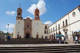
State of Querétaro
1351-007: Historic center of San Juan del Río.
1351-008: Hacienda de Chichimequillas.
1351-009: Chapel of the hacienda de Buenavista.
1351-010:
-

-
 Templo y exconvento de San Agustín in Querétaro.
 -
 Templo y exconvento de San Francisco de Asís in Querétaro.
 -
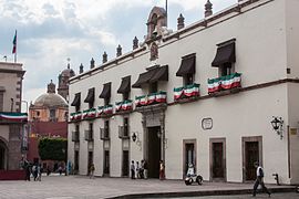 Casa de la Corregidora in Querétaro.
 -

-
 Capilla de Nuestra Señora de Guadalupe in San Juan del Río.
 -
 Hacienda de Chichimequillas, El Marqués municipality.


.jpg)
State of Guanajuato
1351-011: Bridge of El Fraile.
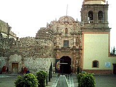
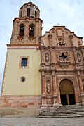
1351-012: Antiguo Real Hospital de San Juan de Dios in San Miguel de Allende.
1351-013:
1351-014: Bridge La Quemada.
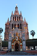
1351-015: Sanctuario de Jesús Nazareno de Atotonilco in the Municipality of San Miguel de Allende.
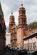
1351-016: Historic center of Guanajuato and its adjacent mines.
-
![Antiguo Real Hospital de San Juan de Dios.[12]](//upload.wikimedia.org/wikipedia/commons/thumb/a/aa/Iglesia_del_Hospital_de_San_Juan_de_Dios_de_San_Miguel_de_Allende%2C_Guanajuato.JPG/240px-Iglesia_del_Hospital_de_San_Juan_de_Dios_de_San_Miguel_de_Allende%2C_Guanajuato.JPG)
-
 Bridge La Quemada.
 -
-

-
 Guanajuato city panorama.
![Antiguo Real Hospital de San Juan de Dios.[12]](/File:Iglesia_del_Hospital_de_San_Juan_de_Dios_de_San_Miguel_de_Allende,_Guanajuato.JPG)


State of Jalisco
1351-017: Historic center of Lagos de Moreno and bridge.
1351-018: Historic center of Ojuelos de Jalisco.
1351-019: Bridge of Ojuelos de Jalisco.
1351-020: Hacienda de Ciénega de Mata.
1351-021: Old Cemetery of Encarnación de Díaz.
-
 Parroquia de la Asunción de María in Lagos de Moreno.
 -
 Parroquia de Nuestra Señora del Refugio in Lagos de Moreno.
 -
 Bridge of Lagos de Moreno.
 -
 Bridge of Ojuelos de Jalisco.
 -
 Mummy in Lagos de Moreno.
 -
 Church in Encarnación de Díaz.
 -
 Old Cemetery in Encarnación de Díaz.


State of Aguascalientes
1351-022: Hacienda de Peñuelas.
1351-023: Hacienda de Cieneguilla.
1351-024: Historic center of
1351-025: Hacienda de Pabellón de Hidalgo.
-
 Church of San Blas in Pabellón de Hidalgo.
 -

-

.jpg)

State of Zacatecas
1351-026: Chapel of San Nicolás Tolentino of the Hacienda de San Nicolás de Quijas.
1351-027: Town of Pinos.
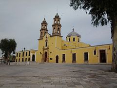
1351-028: Templo de Nuestra Señora de los Ángeles of the town of Noria de Ángeles.
1351-029: Templo de Nuestra Señora de los Dolores in Villa González Ortega.
1351-030: Colegio de Nuestra Señora de Guadalupe de Propaganda Fide.
1351-031: Historic center of Sombrerete.
1351-032: Templo de San Pantaleón Mártir in the town of Noria de San Pantaleón.
1351-033:
1351-034: Architectural set of the town of Chalchihuites.
1351-035: Section of the Camino Real between Ojocaliente and Zacatecas.
1351-036: Cave of Ávalos.
1351-037:
1351-038: Sanctuary of Plateros.
-
-
 Iglesia Principal of the town of Pinos.
 -
-
 El Laberinto ofChalchihuites.
 -
 Plaza de San Agustin in Zacatecas.
 -
 Cajas Reales in Sombrerete.
 -
 Iglesia de Santo Domingo in Sombrerete.
 -
 Sanctuary of Plateros.


State of San Luis Potosí
1351-039:
-

-
 Chapel of San Pedro in Hacienda de Gongorron.
 -
 Calle Universidad street


.JPG)
State of Durango
1351-040: Chapel of San Antonio of the Hacienda de Juana Guerra.
1351-041: Churches in the town of Nombre de Dios.
1351-042: Hacienda de San Diego de Navacoyán and Bridge del Diablo.
1351-043:
1351-044: Churches in the town of Cuencamé and Cristo de Mapimí.
1351-045: Templo de Nuestra Señora del Refugio in the Hacienda La Pedriceña in Los Cuatillos, Cuencamé Municipality.
1351-046: Iglesia Principal of the town of San José de Avino.
1351-047: Chapel of the Hacienda de la Inmaculada Concepción of Palmitos de Arriba.
1351-048: Chapel of the Hacienda de la Limpia Concepción of Palmitos de Abajo.
1351-049: Architectural set of Nazas.
1351-050: Town of San Pedro del Gallo.
1351-051: Architectural set of the town of Mapimí.
1351-052: Town of Indé.
1351-053: Chapel of San Mateo of the Hacienda de San Mateo de la Zarca.
1351-054: Hacienda de la Limpia Concepción of Canutillo.
1351-055: Templo de San Miguel in the town of Villa Ocampo.
1351-056: Section of the Camino Real between Nazas and San Pedro del Gallo.
1351-057:
1351-058: Cave of Las Mulas de Molino.
-
 Plaza de Armas in the Historic centre ofDurango.
 -
 Templo de Cuencamé.
 -
 Town of Mapimí.
 -
 Town of Nazas.
 -
 Ojuela Mine.


State of Chihuahua
1351-059: Town of Valle de Allende.
Undeclared historic locations of the Camino Real in State of Chihuahua
Location
National Historic Trail
In the United States, from the
Pedestrian, bicycle, and equestrian trails have been added to portions of the trade route corridor over the past few decades. These include the existing
Along the trail, parajes (stopovers) that have been preserved today include El Rancho de las Golondrinas. Fort Craig and Fort Selden are also located along the trail.
CARTA
The El Camino Real de Tierra Adentro Trail Association (CARTA) is a non-profit trail organization that aims to help promote, educate, and preserve the cultural and historic trail in collaboration with the U.S. National Park Service, the Bureau of Land Management, the New Mexico Department of Cultural Affairs, and various Mexican organizations. CARTA publishes an informative quarterly journal, Chronicles of the Trail, which provides people with further history and current affairs of the trail and what CARTA, as an organization, is doing to help preserve it.
Chihuahua Trail
The Chihuahua Trail is an alternate name used to describe the route as it passes from New Mexico through the state of Chihuahua to central Mexico.
By the late 16th century, Spanish exploration and colonization had advanced from
See also
- Camino Real in New Mexico - El Camino Real de Tierra Adentro
- El Camino Real (California) – the California Mission Trail
- El Camino Real de Los Tejas– El Camino Real from Texas east to Louisiana
- National Register of Historic Places listings in Socorro County, New Mexico
- Old San Antonio Road – a section of El Camino Real de Los Tejas
- Scenic byways in the United States
- Supply of Franciscan missions in New Mexico
References
- ^ World Heritage Convention, Unesco (29 June 2022). "Camino Real de Tierra Adentro". Unesco World Heritage Convention.
- ^ Snyder, Rachel Louise. "Camino Real Archived 1 December 2008 at the Wayback Machine" American Heritage, April/May 2004.
- ^ "Camino Real de Tierra Adentro – World Heritage List". UNESCO. Retrieved 5 August 2010.
- ^ "Weekly list of actions 11/03/14 through 11/07/14". National Park Service. Retrieved 23 November 2014.
- ^ "Camino Real Tierra Adentro". Archived from the original on 2 February 2021. Retrieved 20 December 2020.
- ^ http://www.colpos.mx/asyd/volumen8/numero2/res-11-001.pdf Archived 27 December 2013 at the Wayback Machine
- ^ "El Camino Real" (PDF). Archived from the original (PDF) on 26 December 2013. Retrieved 5 August 2019.
- ^ a b http://www.saber.ula.ve/bitstream/123456789/28985/1/articulo1.pdf
- ^ "Linea de Presidios de la Frontera Novohispana: 1770 - 1780". cachanilla69.blogspot.mx. 10 August 2013.
- ^ UNESCO World Heritage Convention (2010). "List of sites of the Camino Real de Tierra Adentro".
- ^ http://vamonosalbable.blogspot.mx/search/label/Unesco
- ^ 20°54′57″N 100°44′55″W / 20.91593°N 100.74871°W
Further reading
- Dictionary of American History by James Truslow Adams, New York: Charles Scribner's Sons, 1940
- Boyle, Susan Calafate. Los Capitalistas: Hispano Merchants and the Santa Fe Trade. Albuquerque: University of New Mexico Press, 1997.
- Moorhead, Max L. New Mexico's Royal Road. Norman: University of Oklahoma Press, 1958.
- Palmer, Gabrielle G., et al.. El Camino Real de Tierra Dentro. Santa Fe: Bureau of Land Management, 1993.
- Palmer, Gabrielle G. and Stephen L. Fosberg. El Camino Real de Tierra Dentro. Santa Fe: Bureau of Land Management, 1999.
- Preston, Douglas and José Antonio Esquibel. The Royal Road. Albuquerque: University of New Mexico Press, 1998.
External links
- National Park Service: official El Camino Real de Tierra Adentro National Historic Trail website
- El Camino Real International Heritage Center
- El Camino Real de Tierra Adentro – Integrated education curriculum
- CARTA – El Camino Real de Tierra Adentro Trail Association: website
- N.M.-Monuments.org – "A Road Over Time"