
East Region (Cameroon)
This article includes a list of general references, but it lacks sufficient corresponding inline citations. (August 2009) |
East Region | |
|---|---|
Region | |
Lom-et-Djérem | |
| Government | |
| • Governor | Gregoire Mvongo[1] |
| Area | |
| • Total | 109,002 km2 (42,086 sq mi) |
| Population (2015) | |
| • Total | 835,642 |
| • Density | 7.7/km2 (20/sq mi) |
| HDI (2017) | 0.549[2] low · 7th of 10 |
The East Region (
The East Region has very little
The southwest region is the most endowed with natural resources like oil,timber and plantain plantation
Geography
Land
The
Drainage
The region contains several river systems: the
Relief
Almost the entire territory of the East Region lies on the South Cameroon Plateau that forms the southeastern half of the country. The elevation thus varies between 500 and 1000 metres above sea level except for lower-lying plains of 200 to 500 metres in the extreme southeast centered on the Dja, Boumba, Sangha, and Ngoko Rivers. The land consists largely of monotonous, gently undulating hills known as "half-oranges" due to their resemblance to that fruit.
Climate
The East has a

Plant and animal life
Approximately the lower two thirds of the region is covered in
The government of Cameroon has established four forest and game reserves in the East: the
Animal life is abundant and diverse. The forests are inhabited by numerous species of
Demographics
| Year | Pop. | ±% p.a. |
|---|---|---|
| 1976 | 366,235 | — |
| 1987 | 517,198 | +3.19% |
| 2005 | 771,755 | +2.25% |
| 2015 | 835,642 | +0.80% |
| source:[3] | ||

Settlement patterns
The East had 517,198 inhabitants in 1987, and it remains the most sparsely populated of
The majority of the population is thus primarily situated in
People

The majority of the inhabitants of the East are members of
Most eastern peoples speak their own distinctive languages, though educated individuals usually also know
The people of the East are predominantly

Bantu

The speakers of
Though the capital, Bertoua, is a traditional Gbaya settlement, the region is today a melange of several tribes, including the
Adamawa–Ubangi
The Gbaya are the most populous Ubangi group in the East, and they inhabit most of the Lom and Djerem division (including Bertoua) and the northernmost third of the Kadey division along the Kadey River. They also have smaller population centres, including the village of Gari-Gombo and Djampiel. The Kuo occupy the extreme northeastern corner of the region, including Wendoka. The Gbete (Kepere) live northwest of Bertoua, including the territory from Bélabo west to Yangamo. The Bangantu people live east of the Yokadouma-Moloundou road in the region's southeastern corner.
Baka pygmies

The rest of the region, that which is covered by thick forests and not serviced by roads, is inhabited by the Baka, Babaya, or Babinga pygmies. Though traditionally hunter-gatherers, in recent times, the Baka have established trade with their Bantu neighbours, exchanging wild game for crops or metal tools. This relationship is not always equal, however, and Bantu sometimes take advantage of the Baka, exploiting them for labour or ceding their territory to logging companies without compensation.
The Cameroonian government has tried to encourage the Baka to establish permanent settlements, and some pygmy villages exist in the territory. Most of the Baka remain nomadic, however, living in temporary shelters of leaves and sticks. A much greater force acting to end the Baka's traditional lifestyle is intermarriage and assimilation into neighbouring tribes.
Economy
Agriculture

The vast majority of the inhabitants of the region are
Farms are mostly small-scale affairs planted in clearings in the forest. Farmers clear an area during the dry season using traditional implements such as axes and machetes. The area is then burned, with care taken to preserve fruit trees such as mangoes or plums. At the start of the wet season, spices and common vegetables are planted close to the home and tubers, such as cocoyams and manioc, are placed with plantains in larger plots farther afield. Farmyard manure is used as fertiliser. Crops are then harvested at the beginning of the next dry season.
This method of
Commercial crops also exist. Cocoa and coffee are raised for profit in the areas of Abong-Mbang, Bertoua, and Yokadouma, as well as in the heavy forests south of these areas. Tobacco is grown in the plains north of Batouri. No large-scale commercial livestock exists in the East, though cattle from the northern regions of Cameroon are herded through the province on their way to market in Yaoundé.
Hunting and gathering
Crop growing is often supplemented by
Industry
The major industry of the East is
.In recent years, speculators have found deposits of gold near Bataré-Oya, cobalt near Lomié, and iron and aluminium in other areas. Companies have since moved in to exploit these resources as well. Other industries have a much smaller presence, such as a groundnut-oil mill located in Bertoua.
Transportation

For its vast size, the East has very little transportation infrastructure. With the exception of a few private logging roads, travel through the province is only feasible along the three main roads that cover the territory. The first of these, National Road #10, heads east from Yaoundé, passes through
The East is accessible via
Tourism
Due to the remoteness of the region and the difficulty of travel within it, the East sees very few tourists. The area boasts huge tracts of relatively untouched rain forest, however, and non-governmental organisations such as
Administration and social conditions
Government

A presidentially appointed governor heads the administration of the province from the capital city of Bertoua.
The East is divided into four departments (departements), each headed by a presidentially appointed senior divisional officer or prefect (prefet):
- Boumba-et-Ngoko (Boumba and Ngoko) takes up the southeast and has its centre in Yokadouma.
- Haut-Nyong (Upper Nyong) occupies the southwestern portion and is centred on Abong-Mbang.
- Kadey (also spelled Kadéï or Kadei) forms the central-eastern portion of the territory and is governed from Batouri.
- Lom-et-Djérem (Lom and Djérem) consists of the north of the province and has its capital in Bertoua.
Each of these divisions is further divided into sub-divisions, each headed by a sub-divisional officer or sub-prefect (sous-prefet). Individual towns usually have a mayor, and some villages have a traditional chief, though this person usually holds little actual authority.
Cameroonian politicians have traditionally ignored the East. The region is simply too underpopulated to have much influence in countrywide elections. Eastern residents have in recent years called for more infrastructure improvements from the government, especially the paving of roads. Candidates for office and government officials do occasionally make stops in the region to address such issues, but their message is often simply an excuse for why such improvements would be detrimental to the region. For example, they often argue that paved roads would only allow the forests upon which the region depends to be cut down at an even faster rate.
Education
School attendance rates are difficult to determine for the East, but are generally higher in the towns than in the villages. Primary schools are fairly widely distributed, but most of the region's secondary schools are located in larger villages or in towns, meaning that students from more remote areas must walk long distances, stay with relatives, or rent rooms during the school year. In addition, school fees keep many families from sending their children for an education.
Health
Due to its thick forests and equatorial climate, the East is home to a host of tropical diseases. Chief among these is malaria, which remains a major cause of death in the region. Dengue fever, filariasis, typhoid fever, and tuberculosis are also endemic. In 1997 and 1998, health professionals recorded outbreaks of what may have been the Ebola virus in the southwest near Ngoila. The World Health Organization today doubts that this "bloody diarrhea" was in fact that virus, however.
As with most of sub-Saharan Africa, poor
In recent years, the East has come into focus for its role in the
Government efforts in the 1980s to improve the number and quality of
History
Early population movements
Archaeological finds around Batouri, Bertoua, and Bétaré-Oya attest to human presence in the territory of the East Province since prehistoric times. The earliest inhabitants of the region are commonly assumed to have been the
The Adama-Ubangi peoples came into the territory as part of this same general migration, though they were usually the ones pushing the Bantu peoples further south. Gbaya tradition says that they moved into the region of Bertoua under a leader named Ndiba. His son, Mbartoua, was in power when the Germans arrived.
The coming of the Europeans
For the five centuries or so since the Portuguese first reached the coast of present Cameroon, European explorers made little attempt to push into the intererior. The region was a source of slaves, which were shipped out via the port at Douala or via the Congo River, though the numbers of natives taken were much smaller than in areas closer to the coast.
The
At the end of World War I in 1916, Germany was forced to cede its colony to France. The French divided Cameroon into nine administrative areas, and most of what is now the East Province fell into the Doumé-Loume-Yokadouma district with its capital in Doumé. The French largely continued the colonial practices of the Germans, with forced labor continuing into the early 20th century. They made further infrastructure improvements, as well, such as improving the road from Yaoundé to Bertoua and on to Garoua-Boulaï.
Post-independence
The boundaries of the East Province were finalised after Cameroon gained independence in 1961. The capital was moved from Doumé to Bertoua in 1972.
The region has largely been ignored since independence. One of the few developments of note include the extension of the
In the first months of 2014, thousands of
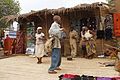
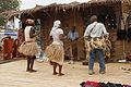
Culture
Traditional dance accessories


Traditional Dances
-
-
-

-
 Tam-tam player


Traditional musical instruments
-
 Tam-tam
 -
 Balafon


References
- ^ "- CRTV". Archived from the original on 2017-11-13. Retrieved 2017-11-13.
- ^ "Sub-national HDI - Area Database - Global Data Lab". hdi.globaldatalab.org. Retrieved 2018-09-13.
- ^ Cameroon: Administrative Division population statistics
- ^ "Cameroon: Location of Refugees and Main Entry Points (as of 02 May 2014) - Cameroon". ReliefWeb. Retrieved 2014-06-08.
- Chrispin, Dr. Pettang, directeur, Cameroun: Guide touristique. Paris: Les Éditions Wala.
- Fanso, V.G. (1989) Cameroon History for Secondary Schools and Colleges, Vol. 1: From Prehistoric Times to the Nineteenth Century. Hong Kong: Macmillan Education Ltd.
- Fitzpatrick, Mary (2002) "Cameroon," Lonely Planet West Africa, 5th ed. China: Lonely Planet Publications Pty Ltd.
- Fomensky, R., M. Gwanfogbe, and F. Tsala, editorial advisers (1985) Macmillan School Atlas for Cameroon. Malaysia: Macmillan Education Ltd.
- Gwanfogbe, Mathew, Ambrose Meligui, Jean Moukam, and Jeanette Nguoghia (1983) Geography of Cameroon. Hong Kong: Macmillan Education Ltd.
- Neba, Aaron, Ph.D. (1999) Modern Geography of the Republic of Cameroon, 3rd ed. Bamenda: Neba Publishers.
- Ngoh, Victor Julius (1996) History of Cameroon Since 1800. Limbé: Presbook.
