
Myakka River State Park
| Myakka River State Park | |
|---|---|
IUCN category V (protected landscape/seascape) | |
 | |
  | |
| Location | Manatee and Sarasota counties, Florida, USA |
| Nearest city | Sarasota, Florida |
| Coordinates | 27°14′22″N 82°19′00″W / 27.23944°N 82.31667°W |
| Area | 37,000 acres (150 km2) |
| Established | February 18, 1941[1] |
| Governing body | Florida Department of Environmental Protection |

Myakka River State Park is a
Environment
Myakka River State Park is in the
Wetlands in the park include marshes and forested wetlands.
A karst sinkhole named Deep Hole is located on the northwest bank of the Myakka River in the Wilderness Preserve. The sink is 135 feet (41 m) deep though no evidence of a spring was found by a 2011–2012 research team.[3]
Rivers in the park support hammocks and floodplain forests. Near the floodplains of spring-fed rivers grow southern coastal plain hydric hammocks, dense forests of evergreen and deciduous hardwood trees. Blackwater rivers support southern coastal plain blackwater river floodplain forests of baldcypress along their banks.[2]
Climate
| Climate data for Myakka River State Park, Florida, 1991–2020 normals, extremes 1956–present | |||||||||||||
|---|---|---|---|---|---|---|---|---|---|---|---|---|---|
| Month | Jan | Feb | Mar | Apr | May | Jun | Jul | Aug | Sep | Oct | Nov | Dec | Year |
| Record high °F (°C) | 89 (32) |
91 (33) |
95 (35) |
98 (37) |
104 (40) |
105 (41) |
101 (38) |
104 (40) |
103 (39) |
98 (37) |
96 (36) |
90 (32) |
105 (41) |
| Mean maximum °F (°C) | 84.5 (29.2) |
85.7 (29.8) |
88.7 (31.5) |
91.8 (33.2) |
95.3 (35.2) |
97.1 (36.2) |
96.6 (35.9) |
97.0 (36.1) |
95.3 (35.2) |
95.9 (35.5) |
88.9 (31.6) |
85.4 (29.7) |
98.4 (36.9) |
| Mean daily maximum °F (°C) | 74.5 (23.6) |
77.6 (25.3) |
80.7 (27.1) |
85.2 (29.6) |
89.8 (32.1) |
91.7 (33.2) |
92.3 (33.5) |
92.5 (33.6) |
90.7 (32.6) |
86.5 (30.3) |
80.8 (27.1) |
76.6 (24.8) |
84.9 (29.4) |
| Daily mean °F (°C) | 62.2 (16.8) |
65.0 (18.3) |
67.9 (19.9) |
72.5 (22.5) |
77.4 (25.2) |
81.2 (27.3) |
82.5 (28.1) |
83.1 (28.4) |
81.4 (27.4) |
76.3 (24.6) |
69.1 (20.6) |
64.8 (18.2) |
73.6 (23.1) |
| Mean daily minimum °F (°C) | 50.0 (10.0) |
52.4 (11.3) |
55.2 (12.9) |
59.8 (15.4) |
64.9 (18.3) |
70.7 (21.5) |
72.8 (22.7) |
73.6 (23.1) |
72.2 (22.3) |
66.1 (18.9) |
57.4 (14.1) |
53.0 (11.7) |
62.3 (16.8) |
| Mean minimum °F (°C) | 31.2 (−0.4) |
34.3 (1.3) |
38.6 (3.7) |
45.6 (7.6) |
54.9 (12.7) |
64.8 (18.2) |
68.7 (20.4) |
69.7 (20.9) |
66.2 (19.0) |
52.3 (11.3) |
41.9 (5.5) |
35.6 (2.0) |
29.4 (−1.4) |
| Record low °F (°C) | 18 (−8) |
22 (−6) |
28 (−2) |
34 (1) |
43 (6) |
50 (10) |
59 (15) |
60 (16) |
58 (14) |
37 (3) |
24 (−4) |
18 (−8) |
18 (−8) |
| Average precipitation inches (mm) | 2.85 (72) |
2.44 (62) |
3.00 (76) |
2.98 (76) |
3.75 (95) |
9.95 (253) |
9.81 (249) |
10.12 (257) |
8.45 (215) |
3.19 (81) |
2.02 (51) |
2.51 (64) |
61.07 (1,551) |
| Average precipitation days (≥ 0.01 in) | 7.2 | 5.6 | 5.8 | 5.2 | 7.3 | 15.4 | 18.7 | 18.6 | 15.5 | 8.2 | 5.3 | 7.0 | 119.8 |
| Source: NOAA[4][5] | |||||||||||||
Things to do

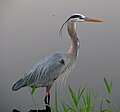
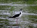
The park is noted for its wildlife and some of the rare birds seen only in Florida, such as the roseate spoonbill, frequent the park. Native flora flourishes in the park. There are many species of fish, amphibians, reptiles, and mammals to learn about and enjoy watching as well.
Myakka River State Park has an excellent system of hiking trails. Walking trails crisscross the eastern side of the park.
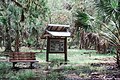
Six primitive campgrounds are accessible by trail throughout the park: Mossy Hammock, Bee Island, Panther Point, Honore, Oak Grove and Prairie.
Horseback riding and biking is permitted on certain designated trails and roads in the park. This part of the park is dominated by expanses of very low vegetation, fields of palmetto, that make a transition to islands, or hammocks, of tall pine and oak trees.
A good portion of the park is accessible by automobile. Myakka River State Park's main road, a 6.5-mile (10.5 km) drive between the north and south ends, leads visitors to a boardwalk out to the river and a lake that is excellent for bird watching.
The main drive is also popular with cyclists, runners, and skaters. Bicycle traffic can be heavy, especially on weekends and holidays.
A short walk from the main road reveals Myakka's canopy walkway, which is North America's first public treetop trail and is a novel suspension bridge and tower providing researchers and visitors with views of the forest canopy and a spectacular above-the-treetops view of the entire park. The walkway is suspended 25 feet above the ground and 100 feet through the hammock canopy, with the tower soaring 74 feet in the air.
Picnic areas, canoeing, boat tours, and developed campsites are available, as well as an outpost, which contains bike and canoe rentals, a souvenir shop, a camping supply store, and the Pink Gator Cafe.
The park even has five cabins that were built not with logs, but with the trunks of native sabal palms.
History
In 1843, a European surveyor by the name of Sam Reid encountered a group of Seminoles who told him the river he encountered was called the "Miarca," which was later spelled on maps as Myakka, as well as the headwaters of the river were called "Locha-notia," which translates to "sleeping turtle." Between the 1850s and 1930s, settlers established cattle to the region and much of the cattle was used for beef in the Civil War. In 1910, Bertha Palmer, a Chicagoan businesswoman, bought a vast amount of land near the Myakka River for cattle and swine ranching. During the Great Depression, President Roosevelt signed the New Deal and funded the Civilian Conservation Corps, where Palmer's land was gifted to be developed into a state park. The Myakka River State Park officially opened in 1941. [6]
References
- ^ Smith, Mark D. "Myakka River State Park". Sarasota History Alive. Sarasota County History Center. Retrieved April 11, 2018.
- ^ a b c "Land Cover Viewer - Map". National Gap Analysis Program. United States Geological Survey. Retrieved February 15, 2013.
- ^ Culter, JK; Bowen, C; Ryan, J; Perry, J; Janneman, R; Lin, W (2013). "Exploration of Deep hole, Myakka river state park, Florida". In: Lang, M.A., and M.D.J. Sayer, editors. 2013. Proceedings of the 2013 AAUS/ESDP Curaçao Joint International Scientific Diving Symposium, October 24–27, 2013, Curaçao. Dauphin Island, AL. American Academy of Underwater Sciences. Archived from the original on July 9, 2014. Retrieved July 6, 2014.
- ^ "NOWData - NOAA Online Weather Data". National Oceanic and Atmospheric Administration. Retrieved May 23, 2021.
- ^ "Summary of Monthly Normals 1991–2020". National Oceanic and Atmospheric Administration. Retrieved May 23, 2021.
- ^ McCarthy, John; Dame, Glenna (November 1983). "A History of the Myakka River" (PDF). Sarasota County Historical Archives: 103.
Gallery
-

-
-
-

-
 The Boat Basin with airboats Gator Gal and Myakka Maiden
 -
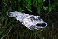 Alligators abound
 -
 Kayaking on the Myakka River
 -
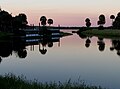
 Myakka River Sunset
 -
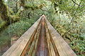 View walking on the Canopy Walkway
 -
 Trails flooded after heavy rains
 -
 The Canopy Walk at Myakka River State Park


External links
- Myakka River State Park at Florida State Parks
- Friends of the Myakka River
- Myakka River State Park at State Parks
- Myakka River State Park at Absolutely Florida
- Myakka River State Park at Visit Florida
- Myakka River State Park at Wildernet
- Myakka River Watershed - Florida DEP[usurped]
| International | |
|---|---|
| National | |