
Limes (Roman Empire)
This article needs additional citations for verification. (April 2018) |
| UNESCO World Heritage Site | |
|---|---|
 The limes Germanicus, 2nd century (Note: Mogontiacum is misspelled) | |
| Criteria | Cultural ii, iii, iv |
| Reference | 430 |
| Inscription | 1987 (11th Session) |
| Extensions | 2005, 2008 |
Limes (Latin; sg., pl.: limites) is a term used primarily for the Germanic border defence or delimiting system of Ancient Rome marking the borders of the Roman Empire.[1][2] The term has been extended in modern times to refer to the frontier defences in other parts of the empire, such as in the east and in Africa.
Overview


The Roman frontier stretched for more than 5,000 kilometres (3,100 mi) from the Atlantic coast of northern Britain, through Europe to the Black Sea, and from there to the Red Sea and across North Africa to the Atlantic coast. The positions of the borders changed especially during the main periods of Roman expansion and contraction, and first became more stable during the early Empire period under Augustus, but the borders continued to change with time in different provinces. The borders had different constituents depending on local needs; often they consisted of natural boundaries (e.g. rivers) with roads behind for easier movement of troops between linked forts (e.g. Danubian Limes), or else roads with linked forts (e.g. Stanegate, Fosse Way).
The remains of the frontiers today consist of vestiges of roads, forts, fortresses, walls and ditches, and associated civilian settlements. The soldiers at a border were referred to as limitanei.[citation needed] They were not expected to win large-scale wars, but rather to deter small-to-medium-sized raiding parties.
Notable examples of Roman frontiers include:
- Hadrian's Wall in northern Britain
- Antonine Wall – in Scotland[3][4]
- Saxon Shore, late Roman coastal forts in South-East England
- Limes Arabicus, the frontier of the Roman province of Arabia Petraea facing the desert
- Limes Tripolitanus, the frontier in modern Libya facing the Sahara
- North-Africa.
- Germanic Limesincluding the:
- Danubian Limes including the:
- Rhaetian Limes(only those elements along the Danube)
- Noric Limes, the frontier of the Roman province Noricum, from the River Inn along the Danube to Cannabiaca (Zeiselmauer-Wolfpassing) in Austria.
- Taurunumin Serbia.
- Moesian Limes, the frontier of the Roman province Moesia, from Singidunum Serbia along the Danube to Moldavia.
- Dacian Limes including:
- Limes Alutanus, the eastern border of the Roman province of Dacia
- Limes Transalutanus, the frontier in the lower Danube
Etymology
The stem of limes, limit-, which can be seen in the genitive case, limitis, marks it as the ancestor of an entire group of words in many languages related to Latin; for example, English
An etymology by Julius Pokorny in Indogermanisches Etymologisches Wörterbuch says that limes comes from Indo-European el-, elei-, lei-, "to bow", "to bend", "elbow". According to Pokorny, Latin limen, "threshold", is related to limes, being the stone over which one enters or leaves the house. Some scholars have viewed the frontier as a threshold. The Merriam–Webster dictionaries take this view, as does J. B. Hofmann in Etymologisches Wörterbuch des Griechischen under leimon. The White Latin Dictionary denies any connection, deriving limen from *ligmen, as in lien from *leig-, "tie". In this sense, the threshold ties together the doorway. W. Gebert also wrote an article discussing the term.[8]
The first use of the term limes[9] as meaning "land border" appears for the first time in 98 AD by Tacitus:[10][11]
...nec iam de limite imperii et ripa, sed de hibernis legionum et de possessione dubitatum (...not only were the frontier of the empire and the banks [of the Danube] in danger but also the winter-quarters of the legions and the provinces).
Its definitive use for the Danubian border seems to date from about 122 in the time of Hadrian:[12]
Per ea tempora et alia frequenter in plurimis locis, in quibus barbari non fluminibus sed limitibus dividuntur, stipitibus magnis in modum muralis saepis funditus iactis atque conexis barbaros separavit (During this period and on many other occasions also, in many regions where the barbarians are held back not by rivers but artificial barriers, [Hadrian] shut them out by tall stakes planted deep in the ground and fastened together in the manner of a palisade).
Some experts suggested that the Germanic limes may have been called Munimentum Traiani (Trajan's Bulwark) by contemporaries, referring to a passage by Ammianus Marcellinus, according to which emperor Julian had reoccupied this fortification in 360 AD.[13]
In Europe
Britain


The frontier in Britain existed from the 1st to the 5th century AD. Initially the Fosse Way road was a frontier and from the 1st to the 2nd century, first the Gask Ridge and then the Stanegate, with their chains of Roman camps and watchtowers, marked the northern boundary of Britannia. Later Hadrian's Wall was built as the frontier and for a short time the Antonine Wall further north. The defence of Hadrian's Wall was achieved through the incorporation forts and castella. Security and monitoring on the coasts in the west and southeast were achieved by forts and by chains of watchtowers or signal towers, both along the coastline.
The garrisons, Exercitus Britannicus[
Saxon Shore

This section of the limes existed from the 3rd to 5th centuries AD and covered the provinces of:
- Britannia Inferior
- Belgica
- Lugdunensis
- Aquitania
This limes of the
The garrisons of the forts were composed of infantry and several cavalry regiments. Monitoring and surveillance of the Channel were the responsibility of the
- Comes litoris Saxonici per Britanniam (Count of the Saxon Shore)
- Dux Belgicae secundae
- Dux tractus Armoricani et Nervicani
Lower Germania

This section of limes existed from the 1st to the 5th century AD and ran through the province of Lower Germania (Germania Inferior).
It lies on the territory of today's
The occupying troops, Exercitus Germaniae Inferioris, consisted mostly of auxilia cohorts. From the 2nd century, the strategic reserve comprised three legions stationed in
Upper Germania and Rhaetia

This limes existed from the 1st to 5th centuries AD and guarded the provinces of:
- Germania Superior
- Rhaetia
It lay on the territory of the present German states of
The land of Agri Decumates that was guarded by this limes had to be vacated by the Romans in 260–285 AD. They moved their bases back to the banks of the Rhine and Danube, which were much easier to defend militarily. The exact route of the limes along the border between Upper Germania and Raetia has not been fully explored. In the late 4th and early 5th centuries, the Rhaetian Limes was reorganized and divided into three sections. The northern border of Rhaetia formed the pars superior (upper part), the western border was the pars media (central part) with the fortified town of Cambodunum and bases from Vemania (Isny im Allgäu) to Cassilacum (Memmingen); the pars inferior (lower part) was the section between Castra Regina (Regensburg) and Batavis (Passau).
The defending troops, Exercitus Germaniae superioris and Exercitus Raeticus, consisted mostly of auxilia cohorts. From the 2nd century, the strategic reserve was formed from three legions stationed in
Danube-Iller-Rhine Limes (DIRL)

This limes existed from the 3rd to the 5th centuries AD and guarded the provinces of:
- Germania Superior
- Rhaetia
It lies on the territory of present-day Germany,
Flotillas of patrol boats were stationed on the large lakes in this region.
- Lake Constance: Numerus Barcariorum (HQ at Brigantium/Bregenz)
- Yverdon).
Comitatenses, ripenses, and liburnaria in this section of the limes were under the command of four generals:
Noricum

This section of the limes existed from the 1st to the 5th century AD and guarded part of the Roman province of Noricum.
It is on the soil of the present-day Austrian states of
The occupying troops, Exercitus Noricus, consisted mostly of auxilia cohorts and a legion stationed in Lauriacum/Enns acted as the strategic reserve. The surveillance and security of the Danube and its tributaries were the responsibility of the Classis Pannonia. Units of the legions, naval and auxiliary forces were commanded by the respective governors. In late antiquity – according to Notitia Dignitatum – four newly established flotillas undertook this task. From the 3rd century, the Norian comitatenses, ripenses and liburnari were under the command of two generals:
Pannonia

This stretch of limes was in use from the 1st to the 5th centuries AD and helped to guard the provinces of:
- Pannonia inferior
- Pannonia
The
Lower Danube
In Africa

At the greatest extent of the Roman Empire, the southern border lay along the deserts of Arabia in the Middle East (see History of the Romans in Arabia) and the Sahara in North Africa, which represented a natural barrier against expansion. The Empire controlled the Mediterranean shores and the mountain ranges further inland. The Romans attempted twice to occupy the Siwa Oasis and finally used Siwa as a place of banishment. However Romans controlled the Nile many miles into Africa up to the modern border between Egypt and Sudan.[citation needed]
In Africa Romans controlled the area north of the Sahara, from the Atlantic Ocean to Egypt, with many sections of limes (Limes Tripolitanus, Limes Numidiae, etc.).[16]
The Fossatum Africae ("African ditch") of at least 750 km controlled the southern borders of the Empire and had many similarities of construction to Hadrian's Wall.
There are similar, but shorter, fossatae in other parts of North Africa. Between the Matmata and Tabaga ranges in modern Tunisia there is a fossatum which was duplicated during World War II.[17] There also appears to be a 20 km fossatum at Bou Regreg, in Morocco, although this would not have been within the scope of the proclamation of the Codex Theodosianus because at that time the province was not in Africa, administratively speaking.[18]
In the south of
Septimius Severus expanded the "Limes Tripolitanus" dramatically, even briefly holding a military presence in the Garamantian capital Garama in 203 AD. Much of the initial campaigning success was achieved by Quintus Anicius Faustus, the legate of Legio III Augusta.
Following his African conquests, the Roman Empire may have reached its greatest extent during the reign of
Fossatum Africae

Fossatum Africae ("African ditch") is a linear defensive structure (limes) that extended over 750 km or more[21] in northern Africa constructed during the Roman Empire to defend and control the southern borders of the Empire in the Roman province of Africa. It is considered to have many similarities of construction to Hadrian's Wall at the northern border of the Empire in Britain. Generally the Fossatum consists of a ditch and earth embankments on either side using the material from the ditch. Sometimes the embankments are supplemented by dry stone walls on one or both sides; rarely, there are stone walls without a ditch. The width of the Fossatum is generally 3–6 m but in exceptional cases may be as much as 20 m. Wherever possible, it or its highest wall is constructed on the counterscarp. Excavations near Gemellae showed the depth there to be 2–3 m, with a width of 1 m at the bottom widening to 2–3 m at the top.[22]
The Fossatum is accompanied by many small watchtowers and numerous forts, often built within sight of one another.


In Asia
The Limes Arabicus was the frontier of the Roman province of Arabia Petraea, facing the desert. It runs from the Gulf of Aqaba to northern Syria, for about 1,500 kilometers (930 mi) at its greatest extent
Post-Roman limites
The Limes Saxoniae in Holstein was established in 810 AD, long after the fall of the Western Roman Empire. Charlemagne considered his empire (later called the Carolingian Empire) as the true successor to the Roman Empire and called himself "Emperor of the Romans". Official edicts were issued in Latin, which affected the naming of the Empire's frontier as well.
In fiction
- The novel series Romanike is set at the Limes Germanicus in the decades until the first assault of Germanic peoples in 161 AD.[23]
- Roman Wall: A Novel, by Winifred Bryher is set in 265 during the Limesfall.[24]
Gallery
-
 Reconstructed east gate of the fort at Welzheim, Germany
 -
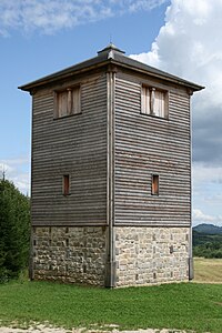 Reconstructed wooden tower nearby Rainau, Germany

_-_Wp12_77.jpg)
See also
- Roman military frontiers and fortifications
- Great Wall – structures of similar scale and function, built by various dynasties in China
- Sasanian defense lines – the borders of the Neo-Persian Empire
- Limitanei – soldiers on the late Roman and early Byzantine limites
- March (territorial entity) – medieval European borderlands
- The Pale – the English-controlled strip of Ireland
References
- ^ Benjamin Isaac, "The Meaning of 'Limes' and 'Limitanei' in Ancient Sources", Journal of Roman Studies, 78 (1988), pp. 125–147
- ISBN 1473853842, 9781473853843
- ^ UNESCO World Heritage Centre. New Inscribed Properties
- ^ "Wall gains World Heritage status'" BBC News. Retrieved 8 July 2008.
- ^ Oxford English Dictionary (1989)
- Journal of Roman Studies, 78 (1988), pp. 125–147
- Journal of Roman Studies, 78 (1988), pp. 125–147; Benjamin Isaac, The Limits of Empire: the Roman Army in the East (Oxford: Oxford University Press, revised edition 1992).
- ^ W. Gebert, "Limes", Untersuchungen zur Erklärung des Vortes und seiner Anwendung, Bonner Jahrbücher Bd. 119, No. 2, 1910, 158–205.
- ^ Carol-Opriş, Ioan; Raţiu, Alexandru; Stoian, Gabriel, Stadiul cercetării siturilor din jud. Braşov şi Covasna ("Stage of the research in Braşov and Covasna Counties"), Raport ştiinţific Privind Derularea Proiectului Strategii Defensive şi Politici Transfrontaliere: Integrarea Spaţiului Dunării De Jos în Civilizaţia Romană (STRATEG) ("Scientific Report on the Progress of the Project "Defensive Strategies and Border Policies: Integration of the Lower Danube Region in Roman Civilization (STRATEG)""), pp. 37-
- ^ Tacitus, De vita et moribus Julius Agricolae, 41, 2-3
- ^ E. Schallmayer, Der Limes. Geschichte einer Grenze, München, 2006, p. 14
- ^ Scriptores Historiae Augustae, De vita Hadriani, XII, 6
- ^ Hessian state archaeologist Prof. E. Schallmeyer, quoted in Schmid, A., Schmid, R., Möhn, A., Die Römer an Rhein und Main (Frankfurt: Societäts-Verlag, revised edition 2006).
- ISBN 0-521-79297-5, pp. 242 245.
- ^ a b ND occ.: XXXIV
- ^ Map of Roman Africa
- ^ Baradez (1949) p. 146.
- ^ Baradez (1949) p. 114.
- ^ a b David L. Kennedy, Derrick Riley (2012), Rome's Desert Frontiers, page 13, Routledge
- R.J. van der Spek, Lukas De Blois (2008), An Introduction to the Ancient World, page 272, Routledge
- ^ This figure depends very much on the way it is measured over the intervals where the Fossatum was not constructed or has disappeared, and includes a significant section which may not be a fossatum.
- ^ Baradez (1949) p. 93.
- ^ The Romanike series, Codex Regius (2006–2014) Archived 2016-08-06 at the Wayback Machine
- ISBN 978-0394443249.
External links
- Frontiers of the Roman Empire: UNESCO Official Website
- Official website of the Verein Deutsche Limes-Straße (in German)
- antikefan.de (in German), German antiquarian site with maps
- Vici.org[permanent dead link] Interactive map with the limes and other Roman castles and sites
- Livius.org: Limes Archived 2015-03-20 at the Wayback Machine
- Antikefan: Roman Limes (German)
- Derlimes.at Official website of the Limes group in Austria) (in German, Serbian, Bosnian, Croatian, Montenegrin)
- Limes, Italian Review of Geopolitics (Italian)
- Official website of the Saalburg, the only fully reconstructed Limes fort (in German, English, French) Archived 2019-10-30 at the Wayback Machine
| National | |
|---|---|
| Geographic | |
| Other | |