
Taftan (volcano)
| Taftan | ||
|---|---|---|
| Koh-i-Taftan ("Mountain of Taftan"), Ultra | ||
| Coordinates | 28°36′00″N 61°07′57″E / 28.60000°N 61.13250°E[6] | |
| Naming | ||
| English translation | The place of heat[7] | |
| Geography | ||
 Taftan Iran | ||
| Location | Last eruption | Uncertain |

Taftan (
Taftan has two main summits, Narkuh and Madehkuh, and various heights have been reported for both summits. The northwestern Narkuh has two
Reports of historical volcanic activity are unclear and the youngest radiometric dates are 6,950 ± 20 years before present. Currently, the volcano features vigorous fumarolic activity that is visible from a great distance and involves numerous vents on Materkuh. Taftan appears to be part of a geothermal area; there are a number of hot springs around the volcano.
Taftan is part of a
Geography and geology

Taftan is in Iran's
Regional setting
Volcanic activity has occurred in parts of Iran since the Cretaceous
Volcanic activity at Taftan itself appears to relate to the subduction of the
The convergence of the two blocks continued even after their collision, generating
Local setting
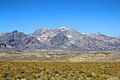
Taftan is the highest mountain in southeast Iran.[7] The topography is overall steep.[21] Deep valleys with U and V shapes have developed on Taftan, and the volcano has a strongly eroded appearance.[17] One of these valleys, Tamindan, may be the Damindan valley in the Avesta religious texts.[22] One series of ignimbrites surrounding Taftan which reaches thicknesses of 50 metres (160 ft) and reaches distances of 15 kilometres (9.3 mi) from the edifice[23] may be 2 million years old.[24]
The basement of Taftan is formed by various
Taftan is a volcano with several summits; the highest two are separated by a saddle and are named Narkuh or Narkooh and Materkuh or Madekooh,[3] which are 2 kilometres (1.2 mi) apart.[32] Narkuh is 4,100 metres (13,500 ft) high and Materkuh 3,950 metres (12,960 ft).[33] There are different heights reported for the summits, some of them placing Materkuh as the higher of the two:[3] for example more recent Iranian maps cited in 2004 show Narkuh with a height of 3,840 metres (12,600 ft) and Materkuh with a height of 3,940 metres (12,930 ft), while Gansser in 1964 indicated a summit height of 4,050 metres (13,290 ft).[8][34] Another report from 1931 claimed a summit height of 3,973 metres (13,034 ft),[35] a report in 1976 stated 4,032 metres (13,228 ft),[36] and a map in 2004 claimed a measurement of 4,061 metres (13,323 ft).[37] These summits rise 2,000 metres (6,600 ft) above the surrounding plains.[14]
Narkuh has two craters, the northern of which is lower and is the source of more lava flows than the southern.
The bulk of the volcano is formed by lava flows, along with
Composition
Taftan has erupted lavas ranging from basaltic andesite to dacite. The dominant rock is andesite, with SiO
2 content ranging from 49.8 to 63.5%.[45] Grey andesites form the youngest rocks on the main summit and contain chlorite schist and biotite gneiss inclusions.[41] The andesites are vesicular.[10] The magma of Taftan volcano is very oxidized, as can be inferred from the composition of the surrounding ignimbrite and fumarole gases.[46]
The lavas of Taftan are porphyritic. Mineral components include biotite,
Fumarolic activity affects surrounding rocks and pyroclastics.
Eruptive history
About five different active eruption periods have been discovered at Taftan volcano.
It is not certain that there were any
Fumarolic and geothermal activity
Taftan displays vigorous
Reportedly in 1897 the smell of the fumaroles was so strong as to be unbearable when one was close to the vents.[5] One report mentioned in a magazine of 1899 indicated the presence of seven steam vents at an altitude of 3,700 metres (12,000 ft), produced audible noise. Their steam plumes were visible at distances of 16–24 kilometres (10–15 mi);[1] later reporting indicated visibility to distances of 100 kilometres (62 mi).[11] Another report in 1999 found a 1.5 by 5 metres (4 ft 11 in × 16 ft 5 in) solfatara surrounded by clay and sulfur deposits that looked like a snowcap.[59] A fumarole field was described on the west side of the southeast cone, the venting clearly visible from a refuge farther down the mountain and covering a surface area of c. 10 square metres (110 sq ft).[34] The name "Taftan" is derived from these exhalations, which make the mountain appear to be burning.[3]
The overall gas composition found at Taftan includes CO
2, H
2S, SO
2 and water.[3] Sulfur is present in high quantities in fumarolic gases, which also contain arsenic. These gases are hence extremely acidic.[46] The fumaroles have altered rocks, forming highly colourful exposures especially on Taftan's eastern flank.[41] Ammonium chloride (salmiak) and sulfur has been collected around fumaroles.[1] The thick sulfur layers on the southeastern summit were formerly extracted for use in Iran and Pakistan. Sulfur and sulfate deposits are also found lower on the volcano, from hot springs around Gooshe, at Sangān and Torshāb.[3]
Hot springs are also found at Taftan, especially at over 3,000 metres (9,800 ft) altitude.
Hot springs and other geothermal manifestations are widespread in Iran and using them to gain geothermal energy has been studied; according to a report of 2002 hot springs at that time were mainly used for therapeutic purposes and bathing.[31] A report in 2002 indicated that Taftan may be a feasible place to install a binary cycle power plant.[70]
Climate and vegetation
The climate at Taftan features cold winters accompanied by
Owing to the height of the mountain, there are distinct vegetation belts at Taftan. The lowlands around the mountain are covered with Artemisia steppe and occasional shrubland. Open scrubs occur in a higher altitude belt of 1,800–2,500 metres (5,900–8,200 ft) where the terrain is rocky, and thorn-cushion vegetation at elevations of 2,600–3,700 metres (8,500–12,100 ft); there is little vegetation in the summit area.[71] The summit of Taftan and several other Iranian volcanoes were deemed national natural monuments in 2002.[72]

-
 Taftan Summit, Sistan and Baluchestan province, Iran
 -
 Mount Taftan, Sistan and Baluchestan province, Iran
 -
 Taftan Shelter, Mount Taftan, Sistan and Baluchestan province, Iran
 -
 Taftan Summit, Sistan and Baluchestan province, Iran
 -
 Taftan Summit, Sistan and Baluchestan province, Iran
 -
 Sulfur, Taftan Mountain, Sistan and Baluchestan province, Iran


See also
- List of volcanoes in Iran
- List of Ultras of West Asia
References
- ^ S2CID 129589512.
- ^ .
- ^ ISBN 978-964-94491-3-5.
- JSTOR 1774906.
- ^ S2CID 128720080.
- ^ a b c "Iran - 54 Mountain Summits with Prominence of 1,500 meters or greater". Peaklist.org. Retrieved 2013-02-10.
- ^ ISBN 978-3-642-16191-9.
- ^ a b c d e Richards et al. 2018, p.3
- ^ a b c d Biabangard, H.A.; Moradian, Abas (2009). "VOLCANOSTRATIGHRAPHY AND DIFFERENT STAGES OF EXPLOSIVE OF TAFTAN VOLCANO". Geosciences. 18 (72): 73–82. Retrieved 13 July 2016.
- ^ a b c Reclus, Elisée (1906). Les volcans de la terre (in French). Société belge d 'astronomie, de météorologie et de physique du globe. pp. 23–24. Retrieved 2 August 2016.
- ^ a b Gansser, 1971, p.320
- ^ a b Gansser, 1971, p.321
- ^ a b Gansser, 1971, p.322
- ^ a b c d e f Sadeghi et al., 2015, p.2
- ^ Richards et al. 2018, p.5
- ^ .
- ^ a b c d e f g h Shakeri et al., 2008, p.830
- ^ Saadat et al., 2011, p.608
- ^ Sadeghi et al., 2015, p.1
- ^ Sadeghi et al., 2015, p.5
- ^ a b c Shakeri et al., 2015, p.50
- ^ Skrine, 1931, p.322
- ^ Richards et al. 2018, p.7
- ^ Saadat, S.; Karimpour, M.H.; Stern, Ch. (2010). "Petrochemical Characteristics of Neogene and Quaternary Alkali Olivine Basalts from the Western Margin of the Lut Block, Eastern Iran" (PDF). Iranian Journal of Earth Sciences. 2: 89. Retrieved 13 July 2016.
- ^ a b Saadat et al., 2011, p.617
- ^ a b c Richards et al. 2018, p.6
- ^ a b Gansser, 1971, p.324
- ^ a b c d Ghazban, 2002, p.810
- Bibcode:2014EGUGA..16.4668P.
- S2CID 129863914.
- ^ a b c Ghazban, 2002, p.809
- ^ a b c d Gansser, 1971, p.325
- ^ . Retrieved 13 July 2016.
- ^ .
- ^ Skrine, 1931, p.321
- ^ JSTOR 1795293.
- ^ Ghazban, 2004, p.46
- ^ a b c Gansser, 1971, p.326
- ^ a b Biabangard and Moradian, 2008, p.357
- ^ Ghazban, 2004, p.45
- ^ a b c d Gansser, 1971, p.328
- ^ Biabangard and Moradian, 2008, p.368. Note, the map clearly indicates southeastward migration.
- ^ a b Gansser, 1971, p.329
- ^ a b Shakeri et al., 2008, p.835
- ^ a b Biabangard and Moradian, 2008, p.360
- ^ a b c d e f Mokhtari, Zahra; Ahmadi, Ali. "INVESTIGATION OF CHEMICAL COMPOSITION OF GAS EXHALATION AND POST VOLCANIC ACTIVITIES OF TAFTAN VOLCANO, SE IRAN". ResearchGate. Geochemistry. Retrieved 13 July 2016.
- ^ Richards et al. 2018, p.4
- ^ .
- ^ Ghazban, 2004, p.48
- ^ Ghazban, 2004, p.52
- ^ Richards et al. 2018, p.11
- ^ Khaiatzadeh, Abbasnejad, Ranjbar 2016, p.7
- ^ a b "Taftan". Global Volcanism Program. Smithsonian Institution.
- ^ Rezaeinahal, Bahar; Zare, Mehdi; Ghorashi, Manoochehr; Nozaiiem, Reza (2014). "REVIEW THE SEISMIC ACTIVITY AND THE SIGNS INDICATE THE VOLCANIC ACTIVITY IN TAFTAN VOLCANIC REGION". Geography and Development. 11 (33): 131–138. Retrieved 13 July 2016.
- .
- Bibcode:2012EGUGA..1413789S.
- ISSN 2194-9042.
- ^ Khaiatzadeh, Abbasnejad, Ranjbar 2016, p.8
- .
- ^ Shakeri et al., 2015, p.51
- ^ Shakeri et al., 2015, p.56
- ^ Shakeri et al., 2008, p.833
- ^ a b Biabangard, H.; Moradian, A.; Bavali, Y. (2009). "STUDY OF THE HYDROGEOCHEMISTRY OF TAFTAN VOLCANO'S MINERAL SPRINGS AND THEIR RELATION TO HARD-ROCK MASSES OF REGION". Geosciences. 19 (73): 99–108. Retrieved 13 July 2016.
- ^ Shakeri et al., 2008, p.834
- ^ Shakeri et al., 2008, p.831
- ^ Shakeri et al., 2015, p.49
- ^ Yousefi, Hossein; Ehara, Sachio; Noorollahi, Younes (January 2007). "GEOTHERMAL POTENTIAL SITE SELECTION USING GIS IN IRAN" (PDF). pangea.stanford.edu. Thirty-Second Workshop on Geothermal Reservoir Engineering. Retrieved 13 July 2016.
- .
- ^ Ghazban, 2002, p.811
- ^ Ghazban, 2002, p.814
- PMID 29447950.
- ISBN 978-0-429-94684-4.
Sources
- Biabangard, H.; Moradian, A. (26 November 2008). "Geology and geochemical evaluation of Taftan Volcano, Sistan and Baluchestan Province, southeast of Iran". Chinese Journal of Geochemistry. 27 (4): 356–369. .
- Gansser, Augusto (August 1971). "The Taftan Volcano (SE Iran)". Eclogae Geologicae Helvetiae. 64 (2): 319–344. .
- Ghazban, Fereydoun (2002). Geological and Geothermal Investigation of Mount Taftan, SE Iran (PDF). Vol. 26. pp. 809–814. ISSN 0193-5933. Archived from the original (PDF) on 14 August 2016. Retrieved 9 August 2016.)
{{cite book}}:|journal=ignored (help - Ghazban, Fereydoun (2004). "Alteration and Geochemistry of Mount Taftan Geothermal Prospect Southeastern Iran" (PDF). Iranian International Journal of Science. 5 (1): 43–62. Archived from the original (PDF) on 21 September 2016. Retrieved 14 July 2016.
- Khaiatzadeh, Ahmad; Abbasnejad, Ahmad; Ranjbar, Hojatallah (2016). "TEPHRA, LAVA FLOW AND NUEE ARDENTE HAZARD ZONING OF TAFTAN VOLCANO, SE IRAN" (PDF). Geography and Environmental Hazards. 5 (18). Retrieved 23 February 2018.
- Richards, Jeremy P.; Razavi, Amir M.; Spell, Terry L.; Locock, Andrew; Sholeh, Ali; Aghazadeh, Mehraj (February 2018). "Magmatic evolution and porphyry–epithermal mineralization in the Taftan volcanic complex, southeastern Iran". Ore Geology Reviews. 95: 258–279. .
- Saadat, Saeed; Stern, Charles R. (July 2011). "Petrochemistry and genesis of olivine basalts from small monogenetic parasitic cones of Bazman stratovolcano, Makran arc, southeastern Iran". .
- Sadeghi, Pouya; Khatib, Mohammad Mahdi; Moridi, Ali Asghar; Bagheri, Sasan (21 November 2015). "3D Mechanical modeling of faults planes based on stress fields: a case study of Saravan fault, SE Iran". Modeling Earth Systems and Environment. 1 (4): 44. S2CID 113297467.
- Shakeri, Ata; Moore, Farid; Kompani-Zare, Mazda (December 2008). "Geochemistry of the thermal springs of Mount Taftan, southeastern Iran". Journal of Volcanology and Geothermal Research. 178 (4): 829–836. .
- Shakeri, Ata; Ghoreyshinia, Sayedkazem; Mehrabi, Behzad; Delavari, Morteza (October 2015). "Rare earth elements geochemistry in springs from Taftan geothermal area SE Iran". Journal of Volcanology and Geothermal Research. 304: 49–61. .
- Skrine, C. P. (October 1931). "The Highlands of Persian Baluchistan". The Geographical Journal. 78 (4): 321–338. JSTOR 1784749.