
Trego County, Kansas
Trego County | |
|---|---|
UTC−5 (CDT) | |
| Congressional district | 1st |
| Website | TregoCountyKS.com |
Trego County is a
History
Early history
For many
19th century
In 1802, Spain returned most of the land to France, but keeping title to about 7,500 square miles. In 1803, most of the land for modern day Kansas was acquired by the United States from France as part of the 828,000 square mile Louisiana Purchase for 2.83 cents per acre.
In 1854, the Kansas Territory was organized, then in 1861 Kansas became the 34th U.S. state. In 1879, Trego County was established.
Geography
According to the
Adjacent counties
- Graham County (north)
- Rooks County (northeast)
- Ellis County (east)
- Ness County (south)
- Gove County (west)
Major highways
 Interstate 70
 U.S. Route 40
- U.S. Route 283
 K-147
K-147
Demographics

| Census | Pop. | Note | %± |
|---|---|---|---|
| 1870 | 166 | — | |
| 1880 | 2,535 | 1,427.1% | |
| 1890 | 2,535 | 0.0% | |
| 1900 | 2,722 | 7.4% | |
| 1910 | 5,398 | 98.3% | |
| 1920 | 5,880 | 8.9% | |
| 1930 | 6,470 | 10.0% | |
| 1940 | 5,822 | −10.0% | |
| 1950 | 5,868 | 0.8% | |
| 1960 | 5,473 | −6.7% | |
| 1970 | 4,436 | −18.9% | |
| 1980 | 4,165 | −6.1% | |
| 1990 | 3,694 | −11.3% | |
| 2000 | 3,319 | −10.2% | |
| 2010 | 3,001 | −9.6% | |
| 2020 | 2,808 | −6.4% | |
| 2023 (est.) | 2,731 | [5] | −2.7% |
| U.S. Decennial Census[6] 1790-1960[7] 1900-1990[8] 1990-2000[9] 2010-2020[2] | |||
As of the
There were 1,412 households, out of which 27.30% had children under the age of 18 living with them, 58.10% were married couples living together, 6.30% had a female householder with no husband present, and 33.70% were non-families. 31.40% of all households were made up of individuals, and 17.70% had someone living alone who was 65 years of age or older. The average household size was 2.27 and the average family size was 2.86.
In the county, the population was spread out, with 23.90% under the age of 18, 5.50% from 18 to 24, 23.50% from 25 to 44, 23.20% from 45 to 64, and 24.00% who were 65 years of age or older. The median age was 44 years. For every 100 females there were 91.10 males. For every 100 females age 18 and over, there were 87.60 males.
The median income for a household in the county was $29,677, and the median income for a family was $40,524. Males had a median income of $26,545 versus $16,927 for females. The
Government
Presidential elections
Trego County is often carried by Republican candidates. The last time a Democratic candidate has carried this county was in 1964. The county has generally voted for Republican candidates by a larger margin by each passing election.
| Year | Republican | Democratic | Third party | |||
|---|---|---|---|---|---|---|
| No. | % | No. | % | No. | % | |
| 2020 | 1,363 | 83.62% | 242 | 14.85% | 25 | 1.53% |
| 2016 | 1,227 | 82.79% | 198 | 13.36% | 57 | 3.85% |
| 2012 | 1,261 | 79.86% | 291 | 18.43% | 27 | 1.71% |
| 2008 | 1,225 | 73.31% | 420 | 25.13% | 26 | 1.56% |
| 2004 | 1,225 | 72.66% | 434 | 25.74% | 27 | 1.60% |
| 2000 | 1,220 | 66.41% | 516 | 28.09% | 101 | 5.50% |
| 1996 | 1,205 | 61.11% | 548 | 27.79% | 219 | 11.11% |
| 1992 | 727 | 38.02% | 608 | 31.80% | 577 | 30.18% |
| 1988 | 979 | 53.47% | 795 | 43.42% | 57 | 3.11% |
| 1984 | 1,491 | 70.40% | 598 | 28.23% | 29 | 1.37% |
| 1980 | 1,340 | 65.43% | 523 | 25.54% | 185 | 9.03% |
| 1976 | 1,025 | 49.56% | 1,003 | 48.50% | 40 | 1.93% |
| 1972 | 1,369 | 66.91% | 621 | 30.35% | 56 | 2.74% |
| 1968 | 1,211 | 58.67% | 623 | 30.18% | 230 | 11.14% |
| 1964 | 974 | 45.05% | 1,177 | 54.44% | 11 | 0.51% |
| 1960 | 1,426 | 61.76% | 875 | 37.90% | 8 | 0.35% |
| 1956 | 1,668 | 69.41% | 726 | 30.21% | 9 | 0.37% |
| 1952 | 1,915 | 75.60% | 608 | 24.00% | 10 | 0.39% |
| 1948 | 1,237 | 51.82% | 1,117 | 46.80% | 33 | 1.38% |
| 1944 | 1,459 | 61.98% | 883 | 37.51% | 12 | 0.51% |
| 1940 | 1,571 | 57.59% | 1,140 | 41.79% | 17 | 0.62% |
| 1936 | 1,012 | 36.00% | 1,783 | 63.43% | 16 | 0.57% |
| 1932 | 918 | 33.76% | 1,751 | 64.40% | 50 | 1.84% |
| 1928 | 1,359 | 57.73% | 982 | 41.72% | 13 | 0.55% |
| 1924 | 1,121 | 58.14% | 399 | 20.70% | 408 | 21.16% |
| 1920 | 1,299 | 75.04% | 395 | 22.82% | 37 | 2.14% |
| 1916 | 867 | 42.07% | 1,094 | 53.08% | 100 | 4.85% |
| 1912 | 160 | 14.34% | 449 | 40.23% | 507 | 45.43% |
| 1908 | 617 | 54.75% | 458 | 40.64% | 52 | 4.61% |
| 1904 | 526 | 60.81% | 264 | 30.52% | 75 | 8.67% |
| 1900 | 360 | 48.39% | 361 | 48.52% | 23 | 3.09% |
| 1896 | 256 | 42.74% | 340 | 56.76% | 3 | 0.50% |
| 1892 | 309 | 50.49% | 0 | 0.00% | 303 | 49.51% |
| 1888 | 477 | 63.86% | 220 | 29.45% | 50 | 6.69% |
Laws
Trego County was a prohibition, or
Education
Unified school districts
Communities

List of townships / incorporated cities / unincorporated communities / extinct former communities within Trego County.[13]
† means a community is designated a Census-Designated Place (CDP) by the United States Census Bureau.
Cities
Unincorporated communities
Ghost towns
Townships
Trego County is divided into seven townships. None of the cities within the county are considered governmentally independent, and all figures for the townships include those of the cities. In the following table, the population center is the largest city (or cities) included in that township's population total, if it is of a significant size.
| Township | FIPS |
Population center |
Population | Population density /km2 (/sq mi) |
Land area km2 (sq mi) |
Water area km2 (sq mi) |
Water % | Geographic coordinates |
|---|---|---|---|---|---|---|---|---|
| Collyer | 14925 | 368 | 1 (2) | 517 (200) | 0 (0) | 0.02% | 39°0′31″N 100°3′55″W / 39.00861°N 100.06528°W | |
| Franklin | 24500 | 60 | 0 (1) | 259 (100) | 0 (0) | 0% | 38°45′42″N 100°4′10″W / 38.76167°N 100.06944°W | |
| Glencoe | 26425 | 70 | 1 (2) | 93 (36) | 0 (0) | 0% | 38°55′40″N 99°38′30″W / 38.92778°N 99.64167°W | |
| Ogallah | 52250 | 214 | 1 (1) | 373 (144) | 0 (0) | 0.05% | 39°0′31″N 99°41′49″W / 39.00861°N 99.69694°W | |
| Riverside | 60150 | 117 | 0 (1) | 296 (114) | 15 (6) | 4.95% | 38°47′32″N 99°42′41″W / 38.79222°N 99.71139°W | |
| WaKeeney | 74475 | 2,398 | 5 (13) | 465 (179) | 0 (0) | 0.03% | 39°0′41″N 99°52′36″W / 39.01139°N 99.87667°W | |
| Wilcox | 79137 | 92 | 0 (1) | 298 (115) | 12 (5) | 3.85% | 38°47′25″N 99°52′37″W / 38.79028°N 99.87694°W |
Former towns and settlements in the county include Wilcox.
Gallery
-
-
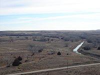 Smoky Hill River valley east of Cedar Bluff Reservoir dam.
 -
 Fort Hays escarpment southeast of Cedar Bluff Reservoir dam.


See also
- Community information for Kansas
- Kansas locations by per capita income
- List of counties in Kansas
- List of townships in Kansas
- List of cities in Kansas
- List of unincorporated communities in Kansas
- List of ghost towns in Kansas
References
- ^ "Welcome to Trego County Economic Development". Trego County, Kansas. Retrieved November 4, 2012.
- ^ a b c "QuickFacts; Trego County, Kansas; Population, Census, 2020 & 2010". United States Census Bureau. Archived from the original on August 21, 2021. Retrieved August 20, 2021.
- ^ "Find a County". National Association of Counties. Retrieved June 7, 2011.
- ^ "US Gazetteer files: 2010, 2000, and 1990". United States Census Bureau. February 12, 2011. Retrieved April 23, 2011.
- ^ "Annual Estimates of the Resident Population for Counties: April 1, 2020 to July 1, 2023". United States Census Bureau. Retrieved April 3, 2024.
- ^ "U.S. Decennial Census". United States Census Bureau. Retrieved July 29, 2014.
- ^ "Historical Census Browser". University of Virginia Library. Retrieved July 29, 2014.
- ^ "Population of Counties by Decennial Census: 1900 to 1990". United States Census Bureau. Retrieved July 29, 2014.
- ^ "Census 2000 PHC-T-4. Ranking Tables for Counties: 1990 and 2000" (PDF). United States Census Bureau. Archived (PDF) from the original on March 27, 2010. Retrieved July 29, 2014.
- ^ "U.S. Census website". United States Census Bureau. Retrieved January 31, 2008.
- ^ "Dave Leip's Atlas of U.S. Presidential Elections".
- ^ "Map of Wet and Dry Counties". Alcoholic Beverage Control, Kansas Department of Revenue. November 2006. Archived from the original on October 8, 2007. Retrieved December 28, 2007.
- ^ a b "General Highway Map of Trego County, Kansas" (PDF). Kansas Department of Transportation (KDOT). January 2013. Archived (PDF) from the original on March 31, 2024.
- Notes
Further reading
- Standard Atlas of Trego County, Kansas; Geo. A. Ogle & Co; 57 pages; 1906.
External links
- County
- Maps
- Trego County Maps: Current, Historic, KDOT
- Kansas Highway Maps: Current, Historic, KDOT
- Kansas Railroad Maps: Current, 1996, 1915, KDOT and Kansas Historical Society
Places adjacent to Trego County, Kansas | ||||||||||||||||
|---|---|---|---|---|---|---|---|---|---|---|---|---|---|---|---|---|
| ||||||||||||||||
Municipalities and communities of Trego County, Kansas, United States | ||
|---|---|---|
| Cities |  | |
| Unincorporated communities | ||
Ghost towns | ||
| Townships | ||
| Footnotes | †This community is designated a Census-Designated Place (CDP) by the United States Census Bureau. | |
| ||
| International | |
|---|---|
| National | |