Tropical cyclone basins

| Part of a series on |
| Tropical cyclones |
|---|
 |
|
Outline Media coverage |
Traditionally, areas of
Overview
| Tropical cyclone basins and official warning centre. | |||
|---|---|---|---|
| Basin | Warning Center | Area of responsibility | Refs |
| Northern Hemisphere | |||
| North Atlantic Eastern Pacific |
United States National Hurricane Center United States Central Pacific Hurricane Center |
Equator northward, African Coast – 140°W Equator northward, 140°W-180 |
[2] |
| Western Pacific | Japan Meteorological Agency | Equator-60°N, 180-100°E | [3] |
| North Indian Ocean | India Meteorological Department | Equator northward, 100°E-45°E | |
| Southern Hemisphere | |||
| South-West Indian Ocean | Meteo France Reunion | Equator-40°S, African Coast-90°E | [4] |
| Australian region | Badan Meteorologi, Klimatologi, dan Geofisika Papua New Guinea National Weather Service Australian Bureau of Meteorology |
Equator-10°S, 90°E-141°E Equator-10°S, 141°E-160°E 10°S-36°S, 90°E-160°E |
[5] |
| Southern Pacific | Meteorological Service of New Zealand |
Equator-25°S, 160°E-120°W 25°S-40°S, 160°E-120°W |
[5] |
Northern Hemisphere
North Atlantic Ocean
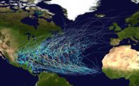
This region includes the North
The United States Atlantic coast and Gulf Coast,
Northeastern Pacific Ocean
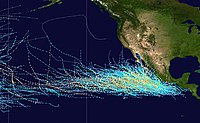
The Northeastern Pacific is the second most active basin and has the highest number of storms per unit area. The hurricane season runs between May 15 and November 30 each year, and encompasses the vast majority of tropical cyclone activity in the region.
Storms that form here often affect western
The
Central Pacific hurricanes are rare and on average 4 to 5 storms form or move in this area annually.
Northwestern Pacific Ocean
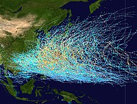
The Northwest Pacific Ocean, or Western North Pacific, is the most active basin on the planet, accounting for one third of all tropical cyclone activity. Annually, an average of 25.7 tropical cyclones in the basin acquire
Tropical storms in this region often affect
North Indian Ocean

This basin is divided into two areas: the Bay of Bengal and the Arabian Sea, with the Bay of Bengal dominating (5 to 6 times more activity). Still, this basin is the least active worldwide, with only 4 to 6 storms per year.
This basin’s season has a double peak: one in April and May, before the onset of
Although the North Indian Ocean is a relatively inactive basin, extremely high population densities in the
Mediterranean Sea
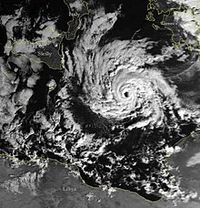
On rare occasions, tropical-like systems that can reach the intensity of hurricanes, occur over the
Meteorological literature document that such systems occurred in September 1947, September 1969, January 1982, September 1983, January 1995, October 1996, September 2006, November 2011, November 2014, and November 2017.[27][28] The 1995 system developed a well-defined eye, and a ship recorded 85 mph (140 km/h) winds, along with an atmospheric pressure of 975 mbar. Although it had the structure of a tropical cyclone, it occurred over 61 °F (16 °C) water temperatures, suggesting it could have been a polar low.[29]
Southern Hemisphere
Within the Southern Hemisphere tropical cyclones generally form on a regular basis between the African coast and the middle of the South Pacific. Tropical and Subtropical Cyclones have also been noted occurring in the Southern Atlantic Ocean at times. For various reasons including where tropical cyclones form, there are several different ways to split the area between the American and African coasts. For instance the World Meteorological Organization define three different basins for the tracking and warning of tropical cyclones. These are the South-West Indian Ocean between the African Coast and 90°E, the Australian region between 90°E and 160°E and the South Pacific between 160°E and 120°W. The United States Joint Typhoon Warning Center also monitors the whole region, but splits it at 135°E into the South Pacific and the Southern Indian Ocean.
South-West Indian Ocean
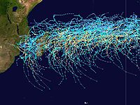
The South-West Indian Ocean is located within the Southern Hemisphere between the Africa's east coast and 90°E and is primarily monitored by the Meteo France's La Reunion RSMC, while the Mauritian, Australian, Indonesian, and Malagasy weather services also monitor parts of it.[30] Until the start of the 1985–86 tropical cyclone season the basin only extended to 80°E, with the 10 degrees between 80 and 90E considered to be a part of the Australian region.[31] On average about 9 cyclones per year develop into tropical storms, while 5 of those go on to become tropical cyclones that are equivalent to a hurricane or a typhoon.
Australian region
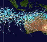
Through the middle of 1985, this basin extended westward to 80°E. Since then, its western boundary has been 90°E.[31] Tropical activity in this region affects Australia and Indonesia. According to the Australian Bureau of Meteorology, the most frequently hit portion of Australia is between Exmouth and Broome in Western Australia.[32] The basin sees an average of about seven cyclones each year, although more can form or come in from other basins, such as the South Pacific.[6][33][34] The tropical cyclone Cyclone Vance in 1999 produced the highest recorded speed winds in an Australian town or city at around 267 km/h (166 mph).[35]
South Pacific Ocean
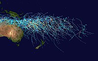
The South Pacific Ocean basin runs between 160°E and 120°W, with tropical cyclones developing in it officially monitored by the Fiji Meteorological Service and New Zealand's MetService.[5] Tropical Cyclones that develop within this basin generally affect countries to the west of the dateline, though during years of the warm phase of El Niño–Southern Oscillation cyclones have been known to develop to the east of the dateline near French Polynesia. On average the basin sees nine tropical cyclones annually with about half of them becoming severe tropical cyclones.
South Atlantic Ocean
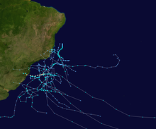
Cyclones rarely form in other tropical ocean areas, which are not formally considered tropical cyclone basins. Tropical depressions and tropical storms occur occasionally in the
See also
References
- Chris Landsea. "Climate Variability table — Tropical Cyclones". Atlantic Oceanographic and Meteorological Laboratory, National Oceanic and Atmospheric Administration. Retrieved October 19, 2006.
- ^ RA IV Hurricane Committee (May 9, 2023). Hurricane Operational Plan for North America, Central America and the Caribbean 2023 (PDF) (Report). World Meteorological Organization. Retrieved July 29, 2023.
- ^ WMO/ESCP Typhoon Committee (March 13, 2015). Typhoon Committee Operational Manual Meteorological Component 2015 (PDF) (Report No. TCP-23). World Meteorological Organization. pp. 40–41. Retrieved March 28, 2015.
- ^ RA I Tropical Cyclone Committee (2023). Tropical Cyclone Operational Plan for the South-West Indian Ocean (PDF) (Report). World Meteorological Organization.
- ^ a b c RA V Tropical Cyclone Committee (2023). Tropical Cyclone Operational Plan for the South-East Indian Ocean and the Southern Pacific Ocean 2023 (PDF) (Report). World Meteorological Organization. Retrieved October 23, 2023.
- ^ NOAA. Retrieved November 30, 2006.
- ^ Climate Prediction Center (August 8, 2006). "Background Information: The North Atlantic Hurricane Season". National Oceanic and Atmospheric Administration. Retrieved March 14, 2007.
- ^ National Hurricane Center. "Tropical Cyclone Climatology". National Oceanic and Atmospheric Administration. Retrieved November 5, 2021.
- ^ Blake, Eric S. (November 14, 2006). "Tropical Cyclone Report: Hurricane Gordon: 10–20 September 2006" (PDF). National Hurricane Center. Retrieved November 29, 2006.
- ^ Franklin, James L. (February 22, 2006). "Tropical Cyclone Report: Hurricane Vince: 8–11 October 2005" (PDF). National Hurricane Center. Retrieved November 29, 2006.
- .
- ^ a b Climate Prediction Center, NOAA (May 22, 2006). "Background Information: East Pacific Hurricane Season". National Oceanic and Atmospheric Administration. Retrieved May 24, 2006.
- ^ a b Chenoweth, Michael and Christopher Landsea (November 2004). "The San Diego Hurricane of 2 October 1858" (PDF). American Meteorological Society. Retrieved December 1, 2006.
- ^ NOAA. Retrieved July 25, 2006.
- ^ a b Central Pacific Hurricane Center. "CPHC Climatology". National Oceanic and Atmospheric Administration. Retrieved March 2, 2007.
- ^ Central Pacific Hurricane Center (1992). "The 1992 Central Pacific Tropical Cyclone Season". Retrieved March 2, 2007.
- ^ Leone, Diana (August 23, 2006). "Hawaiian-named storm hits Johnston Isle". Star Bulletin. Retrieved March 2, 2007.
- NOAA. Retrieved July 25, 2006.
- ^ Weyman, James C. and Linda J. Anderson-Berry (December 2002). "Societal Impact of Tropical Cyclones". Fifth International Workshop on Tropical Cyclones. Atlantic Oceanographic and Meteorological Laboratory. Retrieved April 26, 2006.
- ^ Shoemaker, Daniel N. (1991). "Characteristics of Tropical Cyclones Affecting the Philippine Islands" (PDF). Joint Typhoon Warning Center. Archived from the original (PDF) on February 5, 2012. Retrieved November 29, 2006.
- ^ Why Typhoon Haiyan Caused So Much Damage (Report). NPR. November 11, 2013. Retrieved November 25, 2017.
- ^ Joint Typhoon Warning Center (2004). "1.2: North Indian Tropical Cyclones". 2003 Annual Tropical Cyclone Report. Archived from the original on June 7, 2011. Retrieved November 29, 2006.
- ISBN 0471994065
- ^ "Medicanes: cataloguing criteria and exploration of meteorological environments Archived March 29, 2019, at the Wayback Machine". www.tethys.cat.
- .
- ^ Microsoft Word – EGS2000-Plinius-II-Meneguzzo.doc Archived May 25, 2003, at the Wayback Machine
- ISBN 978-0-521-62430-5. Retrieved January 27, 2011.
- ^ Schwartz (November 7, 2011). "TXMM21 KNES 071819". Satellite Services Division. National Oceanic and Atmospheric Administration. Archived from the original on November 12, 2011. Retrieved November 7, 2011.
- ^ "DR. JACK BEVEN'S Images of the Mediterranean 'Hurricane' (1995) Archived June 5, 2011, at the Wayback Machine". www.mindspring.com.
- DOC). Archived from the originalon September 8, 2006. Retrieved November 29, 2006.
- ^ a b G. Kingston (August 1986). "The Australian Tropical Cyclone Season" (PDF). Australian Meteorology Magazine. 34: 103. Retrieved April 29, 2013.
- ^ "Tropical Cyclones in Western Australia – Climatology". Bureau of Meteorology. Retrieved August 8, 2006.
- ^ "BoM — Severe Weather Event". Bureau of Meteorology. Retrieved October 19, 2008.
- ^ "Tropical Cyclone Trends". Bureau of Meteorology. Archived from the original on September 23, 2012. Retrieved October 19, 2008.
- ^ "BoM — Cyclone Vance produces highest recorded wind speed in Australia". Bureau of Meteorology. Retrieved October 19, 2008.
