
Zhili
| Zhili | ||
|---|---|---|
Hanyu Pinyin Zhílì | | |
| Wade–Giles | Chih2-li4 | |
Zhili, alternately romanized as Chihli, was a northern administrative region of China since the 14th-century that lasted through the Ming dynasty and Qing dynasty until 1911, when the region was dissolved, converted to a province, and renamed Hebei in 1928.
History
The name Zhili means "directly ruled" and indicates regions directly ruled by the imperial government of China..
During the Qing dynasty, Nanjing lost its status as the "second capital" and Southern Zhili was reconstituted as a regular province, Jiangnan, while Northern Zhili was renamed Zhili Province. In the 18th century the borders of Zhili province were redrawn and spread over what is today Beijing, Tianjin and the provinces of Hebei, Western Liaoning, Northern Henan, and the Inner Mongolia Autonomous Region.[citation needed]
After the collapse of Qing dynasty, in 1911, the National Government of the Republic of China converted Zhili into a province as Zhili Province. In 1928 the National Government assigned portions of northern Zhili province to its neighbors in the north and renamed the remainder Hebei Province.
See also
- Sili Province, a similar administrative region during the Han dynasty
- Zhongshu Sheng, a similar administrative region during the Yuan dynasty
- South Zhili, similar administrative regions during the Ming dynasty
Gallery
-
 Zhili during the Republican era
 -
 A 1682 map of the "Kingdom of China, Presently CalledMangi", using the names "Peking" (Beijing) and "Nangking" (Nanjing) to refer to the Northern and Southern Zhilis
 -
 The eastern half of D'Anville's 1734 map of China, Chinese Tartary, and Tibet, displaying "Pe-tche-li" (North Zhili) after its southern counterpart became known as "Kiang-nan" (Jiangnan)
 -
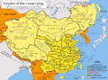 TheQing Empirein 1820, with pinyin romanization
 -
 A map from 1861, which shows "Chihli" (Zhili). The former Jiangnan had already been divided between "Kiangsu" (Jiangsu) and "Nganhwui" (Anhui)


References
- ^ Bird, Thomas (2018-08-16). "More than Beijing's backyard: Hebei in China, where historical treasures shine through the pollution". South China Morning Post. Hong Kong. Retrieved 2024-04-01. - See Jeremiah Jenne's statements.
- ^ Susan Naquin, Peking: Temples and City Life, 1400-1900, p xxxiii
External links
- (in English and Chinese) Complete Map of the Seven Coastal Provinces from 1821 to 1850