Aruchavank
| Aruchavank Արուճավանք | |
|---|---|
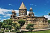
 The Church of Aruch with collapsed dome, 2008. | |
| Religion | |
| Affiliation | Armenian Apostolic Church |
| Location | |
| Location | Aruch, Aragatsotn Province, |
 Shown within Armenia  Aruchavank (Aragatsotn) | |
| Geographic coordinates | 40°17′21″N 44°04′50″E / 40.289078°N 44.080572°E |
| Architecture | |
| Type | Domed hall single-nave basilica |
| Style | Armenian |
| Completed | 660s |
| Dome(s) | 1 (collapsed) |
Aruchavank or the Cathedral of Aruch (Արուճավանք; also Surb Grigor) is situated on a rocky plateau at the western foot of
History
Aruch became a citadel in the later Middle Ages. The ruins of the palace were excavated in 1947 and between 1950 and 1952. The remains of two structures of the palace complex of Prince Grigor Mamikonian were found on the south side of the church of St. Grigor.
There is some controversy as to the exact date of the completion of this church because of the reference in the inscription to the reign of the Byzantine Emperor
The church was restored during 1946–1948, except for the drum and cupola. The church had been extensively damaged by earthquakes and possibly by its use as a fortress in the 16th and 17th centuries (Oramanian, 1948).[3]
Architecture
Aruchavank is a domed hall single-nave basilica type structure. Its drum and drum have since collapsed prior to restoration efforts.
Gallery
-
 Map of Aruchavank and surrounding region.
 -
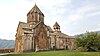
 South façade of the cathedral.
 -
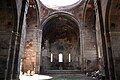 Apse of Aruch cathedral.
 -
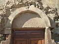 Inscription on the tympanum over the main portal.
 -
 One of two capitals from the ruins just outside the church.


Notes and references
- ^ Encyclopedia of Armenia; Armenian Studies Program at CSU, Fresno
- Der Nersessian, 1969; 670's according to Mnatsakanyan in Aknark, 1964, and Haroutyunyan 1975; 666 by Manutcheryan, 1977.
- ^ Aruchavank at Armenica Archived October 10, 2007, at the Wayback Machine
External links
- Aruchavank at Armenica.org
- Aruch Cathedral at ArmeniaPedia
- About Aruchavank Archived 2021-03-04 at the Wayback Machine