
Entrada Sandstone
| Entrada Sandstone | |
|---|---|
| Stratigraphic range: | |
| Location | |
| Coordinates | 39°15′40″N 110°32′35″W / 39.261°N 110.543°W |
| Region | Colorado Plateau |
| Country | United States |
| Type section | |
| Named for | Entrada Point, northern San Rafael Swell |
| Named by | James Gilluly and J.B. Reeside, Jr. (1928) |
 Entrada Sandstone (the United States)  Entrada Sandstone (Utah) | |
Description
At its
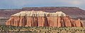
At the reference section in the Kaiparowitz Basin, the Entrada is 314 meters (1,030 ft) thick and is divided into three informal members. The lower member is 113 meters (371 ft) of orange-red silty sandstone, with occasional beds of red mudstone, corresponding to the earthy facies. The middle member is 132 meters (433 ft) of red to green mudstone interbedded with red to white sandstone. The upper member is 69 meters (226 ft) of crossbedded white sandstone.[6] The white color is attributed to bleaching by organic-rich fluids from overlying beds. The formation rests on the Carmel Formation and is overlain by the Morrison Formation.[7]
In the
In the San Juan Basin of northwestern New Mexico, the Entrada consists of upper and lower sandy members and a medial silty member, the Rehoboth Member. The Curtis Formation is sometimes absent and the Entrada then overlies Chinle Formation. It is overlain by the Todilto Formation. Southeast of Fort Defiance, Arizona, the lower sandy beds are assigned to the Iyanbito Member. Total thickness is up to 37 meters (121 ft).[8]
In the Slick Rock, Colorado area, the Entrada is divided into a "middle sandstone", the Rehoboth Member, and the Slick Rock Member, in ascending order.[9]
The Entrada has been dated to the early to middle Callovian stage of the latest Middle Jurassic.[10]
-
 Entrada Sandstone overlain by Curtis Formation in Capitol Reef National Park's Cathedral Valley
 -
 Entrada Formation at Curtis Point, Emery County, Utah.
History of investigation
The Entrada Sandstone was named as one of the four formations of the San Rafael Group by James Gilluly and Reeside in 1928.[4] Gregory and Moore worked out the geographic extent of the formation and gave an overview of it in 1931.[11] The extent was revised several times afterwards (most recently in 1992 by Condon).[12] It was divided into the Gunsight Butte, Cannonville, and Escalante members by Thompson and Stokes in 1970.[13] The principal reference for the formation was written in 1988 by Peterson.[5]
Members
Entrada members are (in alphabetical order):
- Cannonville Member (UT)[13]
- Cow Springs Member (AZ); equivalent to the upper member at the reference section in southern Utah[14]
- Dewey Bridge Member (CO, UT) - named after the type locality at
- Escalante Member (UT)[13]
- Henrieville Member (UT);[13] abandoned by Peterson in 1988.[16]
- Exeter Member (NM)[17]
- Gunsight Butte Member (UT)[13]
- Iyanbito Member (NM)[18]
- Moab Member (CO, UT) or Moab Tongue (CO, UT) - named after the type locality of Moab, Utah. The whitish sands from inland dunes make up this "cap rock" layer, as seen atop Delicate Arch and Broken Arch in Arches National Park.[15]
- Red Mesa Member (AZ, NM, UT)[19]
- Slick Rock Member (CO, UT) - named for the type locality at Slick Rock, Colorado; rounded beach sands were cemented together to create this uniform layer.[15]
Places found

Entrada Sandstone is found in these geologic locations:
- Anadarko Basin[4]
- Black Mesa Basin[20]
- Great Basin province[21]
- Green River Basin[22]
- Las Vegas-Raton Basin[23]
- Paradox Basin[12]
- Piceance Basin[15]
- Plateau Sedimentary Province[11]
- San Juan Basin[10]
- Sierra Grande Uplift[17]

Found in these parklands (incomplete list):
- Arches National Park
- Capitol Reef National Park
- Goblin Valley State Park
- Kodachrome Basin State Park
Spatial distribution:
- spatial distribution of Entrada Sandstone in Macrostrat
References
- doi:10.3133/b1633AC.
- ^ Lucas, S.G.; Anderson, O.J. (1997). "The Jurassic San Rafael Group, Four Corners region" (PDF). New Mexico Geological Society Guidebook. 48: 117–120. Retrieved 26 October 2021.
- ^ Share, Jack (2011). "The formation of the Entrada Sandstone: Tectonics, Accommodation space, Wind and lots of Sand". Written in Stone.
- ^ doi:10.3133/pp150.
- ^ a b c Peterson 1988, pp. B13-56.
- ^ Peterson 1988, pp. B21, 48–52.
- ^ Peterson 1988, pp. B21.
- ^ a b c O'Sullivan, Robert B. (2003). "The Middle Jurassic Entrada Sandstone in northeastern Arizona and adjacent areas" (PDF). New Mexico Geological Society Guidebook. 54: 303–308. Retrieved 25 October 2021.
- ^ O'Sullivan 2003, p. 307.
- ^ doi:10.3133/b1633AC.
- ^ doi:10.3133/pp164.
- ^ doi:10.3133/pp1505A.
- ^ a b c d e Thompson, A.E.; Stokes, W.L. (1970). "Stratigraphy of the San Rafael Group, southwest and south central Utah". Utah Geological and Mineral Survey Bulletin. 87.
- ^ Peterson 1988, pp. B27-29.
- ^ .
- ^ Peterson 1988, p. 25.
- ^ a b Lucas, S.G.; Kietzke, K.K.; Hunt, A.P. (1985). "The Jurassic System in east-central New Mexico" (PDF). New Mexico Geological Society Field Conference Guidebook. 36: 213–242. Retrieved 2 September 2020.
- doi:10.3133/pp1062.
- ^ Lucas & Anderson 1997, p. 117.
- ^ Peterson 1988, p. B27.
- ^ Mackin, J.H. (1954). "Geology and iron ore deposits of the Granite Mountain area, Iron County, Utah". U.S. Geological Survey Miscellaneous Field Studies Map. MF-l4. Retrieved 26 October 2021.
- ^ Rowley, P.D.; Hansen, W.R. (1979). "Geologic map of the Plug Hat quadrangle, Moffat County, Colorado". U.S. Geological Survey Geologic Quadrangle Map. GQ-1514. Retrieved 26 October 2021.
- doi:10.3133/b1071D.
Further reading
- USGS GEOLEX database entry for Entrada Sandstone Accessed 18 March 2006 (public domain text)
External links
- Entrada Sandstone in Goblin Valley State Park
- The Middle Jurassic Entrada Sandstone in Northeastern Arizona and Adjacent Areas, 2003, New Mexico Geological Society Guidebook, Geology of the Zuni Plateau