
Carlile Shale
| Carlile Shale | |
|---|---|
Ma | |
Juana Lopez (CO, NM) Codell Sandstone Blue Hill Shale Fairport Chalk | |
| Underlies | Niobrara Formation |
| Overlies | Greenhorn Limestone |
| Thickness | 170–230 feet (52–70 m) |
| Lithology | |
| Primary | Shale, chalky to carbonaceous |
| Other | Limestone Sandstone Siltstone Septarians Bentonite |
| Location | |
| Coordinates | 38°22′34″N 104°58′44″W / 38.376°N 104.979°W |
| Region | Mid-continental |
| Country | |
| Type section | |
| Named for | Carlile Spring and Carlile Station, 21 mi west of Pueblo, Colorado[1] |
| Named by | Gilbert |
| Year defined | 1896 |
 Carlile Shale (the United States)  Carlile Shale (Colorado) | |
The Carlile Shale is a
formation in the central-western United States, including in the Great Plains region of Colorado, Kansas, Nebraska, New Mexico, North Dakota, South Dakota, and Wyoming.[2]
History of investigation
The Carlile Shale was first named by Grove Karl Gilbert for exposures at Carlile Spring, located about 21 miles (34 km) west of Pueblo, Colorado. He described it as a medium gray shale, capped with limestone or sandstone, and assigned it to the Benton Group.[3] By 1931, William Walden Rubey and his coinvestigators had mapped it into Kansas[4] and the Black Hills. Rubey also first assigned it to the Colorado Group.[5] C.H. Dane assigned it to the Mancos Shale in New Mexico in 1948.[6]
Description
The formation is composed of marine deposits of the generally retreating phase (hemi-cycle) of the
unconformity in much of the outcrop area, but where an unconformity is not discernible, the boundary is typically placed at the first resistant, fine-grained limestone bed at the base of the Niobrara Formation.[9]
Gallery
-
 The lower 25 feet (7.6 m) of the Fairport Chalk member in southern Ellis County, Kansas.
 -

-
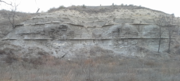
 The bare Blue Hill Shale slopes at Yocemento as they appeared in 1873

.jpg)
.jpg)
Fossil content
Upper Turonian series plesiosaur remains are among the fossils that have been recovered from the strata of its Blue Hill Shale Member in Kansas.[10] The Carlile in eastern South Dakota contains shark teeth, fossil wood and leaves, and ammonites.[11]
Reptiles
Crocodyliforms
Crocodyliforms
| ||||||
|---|---|---|---|---|---|---|
| Genus | Species | Location | Stratigraphic position | Material | Notes | Images |
| Terminonaris | T. cf. T. browni | Russell County, Kansas.[12] | Fairport Chalk Member.[12] | A partial rostrum.[12] | A pholidosaur. | |
Plesiosaurs
| Plesiosaurs | ||||||
|---|---|---|---|---|---|---|
| Genus | Species | Location | Stratigraphic position | Material | Notes | Images |
| Megacephalosaurus | M. eulerti | Near Fairport, Kansas.[13] | Fairport Chalk Member.[13] | A skull & anterior cervical material (FHSM VP-321).[13] | A pliosaurid. |  |
Plesiosauria
|
Mitchell County, Kansas.[10] | Blue Hill Member.[10] | Portions of a rib (FHSM VP-17299).[10] | May represent a large elasmosaur or pliosaur. | ||
Squamates
Squamates
| ||||||
|---|---|---|---|---|---|---|
| Genus | Species | Location | Stratigraphic position | Material | Notes | Images |
| Coniasaurus | C. cf. C. crassidens | Russell County, Kansas.[14] | Fairport Chalk Member.[14] | 2 incomplete vertebrae (FHSM VP-4418).[14] | A dolichosaurid. |  |
Russellosaurina
|
Ellis County, Kansas.[15] | Middle of the Fairport Chalk Member.[15] | 7 successive proximal caudal vertebrae (FHSM VP-17564).[15]
|
A russellosaurine mosasaur .
|
||
Fish
Cartilaginous fish
Cartilaginous fish
| ||||||
|---|---|---|---|---|---|---|
| Genus | Species | Location | Stratigraphic position | Material | Notes | Images |
| Cretodus | C. houghtonorum | North-central Kansas.[16] | Blue Hill Shale.[16] | A partial skeleton consisting of 134 disarticulated teeth, 61 vertebrae, 23 placoid scales, and fragments of calcified cartilage.[16] | A mackerel shark .
|
|
| Cretoxyrhina | C. mantelli | Dixon County, Nebraska.[17] | Fairport Chalky Shale Member.[17] | A tooth ( UNSM 129549).[17]
|
A large mackerel shark .
|
.jpg) |
| Ptychodus | P. latissimus | Kansas.[18] | Codell Sandstone Member.[18] | 3 teeth.[18] | A ptychodontid .
|
|
| P. mammillaris | North of Schoenchen, Ellis County, Kansas.[19] | Fairport Chalk Member.[19] | A medial tooth (FHSM VP-15284).[19] | A ptychodontid .
|
 | |
| P. sp. | Ellis County, Kansas.[20] | Blue Hill Shale Member.[20] | A tooth contained in a coprolite (FHSM VP-13325).[20] | A ptychodontid .
|
||
See also
- Volcanic mineralization of the Greenhorn cycle:
- Bentonite, sedimentary volcanic ash (named for the original Graneros/Greenhorn/Carlile classification), generally showing some weathered iron stain in the Colorado Group
- Pyrite, precipitation of volcanic sulfuric acid with oceanic iron as FeS2
- Limonite, pyrite in limestone weathered to HFeO2 (rust stain or yellow ochre)
- Selenite, CaSO4 associated with Bentonite seams and ochre[21]
- Plesiosaur stratigraphic distribution
References
- ^ "Geologic Unit: Carlile". National Geologic Database. Geolex — Unit Summary. United States Geological Survey. Retrieved 2017-02-03.
- ^ USGS.gov: Mineral resources of the Niobrara and Carlile Formations
- doi:10.3133/ar17_2.
- ^ Rubey, W.W.; Bass, N.W. (1925). "The geology of Russell County, Kansas, with special reference to oil and gas resources". Kansas Geological Survey Bulletin. 10 (1): 1–86.
- doi:10.3133/pp165A.
- ^ Dane, C.H. (1948). "Geology and oil possibilities of the eastern side of the San Juan Basin, Rio Arriba County, New Mexico". U.S. Geological Survey Oil and Gas Investigations Map. OM-78. Retrieved 23 November 2020.
- .
- .
- CiteSeerX 10.1.1.513.8769.
- ^ a b c d Jstor.org: "Probable plesiosaur remains from the Blue Hill Shale (Carlile Formation)" in Kansas", Kansas Academy of Science, 2009.
- ^ [1] William A. Cobban and E.A. Merewether (1983), Stratigraphy and paleontology of mid-Cretaceous rocks in Minnesota and contiguous areas. USGS Professional Paper 1253.
- ^ S2CID 86273062.
- ^ S2CID 130165209.
- ^ S2CID 86027583.
- ^ S2CID 84678673.
- ^ S2CID 209439997.
- ^ S2CID 88299661.
- ^ S2CID 226238444.
- ^ S2CID 85825569.
- ^ JSTOR 3628001.
- ^ Alvin R. Leonard; Delmar W. Berry (1961). Geology and Ground-water Resources of Southern Ellis County and Parts of Trego and Rush Counties, Kansas, Bulletin 149. University of Kansas Publications, State Geological Survey of Kansas. p. Geologic Formations in Relation to Ground Water.
The upper 175 feet of the Carlile is classed as the Blue Hill Shale member. Most of it is blue-gray fissile argillaceous shale that contains selenite crystals and flakes of bright yellow ochre.