
Greenford
Greenford (/ˈɡriːnfərd/) is a large town in the London Borough of Ealing in west London, England, lying 11 miles (18 km) west from Charing Cross. It has a population of 46,787 inhabitants, or 62,126 with the inclusion of Perivale.
Greenford is served by
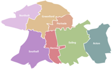
Nearby places include Yeading, Hanwell, Perivale, Southall, Northolt, Ealing, Sudbury and Sudbury Hill. The most prominent landmark in the suburb is Horsenden Hill, 279 feet (85 m) above sea level.
Greenford covers a large area, including the two miles of Greenford Road, giving it three localities: North Greenford, Greenford Green, and Greenford Broadway – this is also reflected in the names of the
Toponymy
The name is first recorded in 848 as Grenan forda. It is formed from the Old English 'grēne' and 'ford' and means 'place at the green ford'. Greenford was known as Great Greenford in order to distinguish it from Little Greenford, which is now known as Perivale (Greenford and Perivale, though different places, still share the UB6 postal code). The affixes 'Magna' and 'Parva' have also been used to denote the difference.[5]
History
Greenford was an ancient parish in the historic Elthorne Hundred, county of Middlesex.
Industrial
Greenford is considered to be birthplace of the modern
J. Lyons and Co.

Post
The factory officially opened in July 1921, with the first single-storey buildings known as "Zig-Zag" due to their northern light-aligned windows allowing maximum light into the production area. There were steam and electrical power plants on site, which powered both the plant as well as the staff canteen and medical facilities, accessible to all plant employees and their dependents.[7] Transport docks and a canal basin had been developed, allowing shipment of tea and coffee directly from London Docks into HM Customs excise controlled bonded warehouses. The extensive onsite railway infrastructure allowed precise positioning of heavy raw goods into the factory, as well as the extraction of finished product. Lyons bought their own steam shunters to move wagons between the GWR exchange sidings and the factory system.[7]
Lyons quickly became Greenford's biggest employer. A later pioneer in electronic machines and computing, Lyons deployed the latest factory automation technology, making Greenford a showplace that was regularly visited by the media, academics, competitors and royalty, with more than one visit by
After the merger of Lyons with
Art and culture
Five hundred yards north east from William Perkin's dye factory was a triangular field in which he kept horses. On this ground was built the Oldfield Tavern public house, which became a popular venue for a rock group called the Detours, who met a drummer there called Keith Moon. On Thursday 20 February 1964 they were introduced to the audience of the Oldfield Tavern as the Who.[8][9] (The tavern has not survived, however, and has since been replaced by a small block of flats and a Texaco petrol station). Andy Locke, Dave Kerr-Clemenson and Wal Scott were all in Edison Lighthouse, and with chart-topping Love Grows all came from Greenford.[citation needed]
Expansion
| 1881 | 538 |
|---|---|
| 1891 | 545 |
| 1901 | 672 |
| 1911 | 843 |
| 1921 | 1,199 |
| Absorbed by Ealing parish ► | |
| source: UK census | |
Education
Primary and Junior Schools
- Coston Primary School[10]
- Horsenden Primary School[11][10]
- Oldfield Primary School[10]
- Our Lady of the Visitation Catholic Primary School[10][12][13]
- Selborne Primary School[10]
- Stanhope Primary School[15][10]
- The Edward Betham CofE Primary School[10]
- Vicar's Green Primary School[10]
High schools
- Greenford High School (an amalgamation of Stanhope Secondary boys school, Costons Girls School and Greenford Grammar school)[16][17]
- The Cardinal Wiseman Catholic School[17]
- William Perkin Church of England High School (an Academy High School[18][17]
Transport

The A40, a major dual-carriageway, serves the area.
Tube
North Greenford is served by

Rail
Buses
Greenford has the following bus routes travelling through it:
Geography
The town lies between about 33 feet (10 m) and 98 feet (30 m)
Parks and recreation
The grounds of the former Ravenor Farm has become Greenford's largest park; Ravenor Park is the venue for the annual Greenford Carnival, which is held every July.[19]
Until 1910, the land that formed Ravenor Farm/Ravenor Park was a detached part of
There are also Perivale Wood, the Horsenden Hill, and Northala Fields near Northolt, Marnham Fields, and Brent Valley Park.
Neighbouring areas
Neighbouring areas (counted from Greenford Green) | ||||||||||||||||
|---|---|---|---|---|---|---|---|---|---|---|---|---|---|---|---|---|
| ||||||||||||||||
Demography
Greenford is covered by three
| Ward | Detached | Semi-detached | Terraced | Flats and apartments[20][21] |
|---|---|---|---|---|
| Greenford Broadway | 5.0% | 22.1% | 20.9% | 51.6% |
| Greenford Green | 4.8% | 39.1% | 26.7% | 29.4% |
| North Greenford | 4.4% | 35.0% | 40.2% | 20.2% |
The median house price as of 2014 was £249,000 in Greenford Broadway, £307,000 in Greenford Green, and £345,000 in North Greenford. In Greenford Green and North Greenford, over 60% of houses are owned, whereas in Greenford Broadway a majority are rented. The population are from a diverse set of backgrounds including Polish, English and other BAME backgrounds (i.e. Black, Asian and minority Ethnic). The median age of those from Black, Asian and minority ethnic backgrounds was 33, 34 and 34 years respectively.[22]
Sport and leisure
Greenford has two Non-League football teams London Tigers F.C. who play at the Avenue Park Stadium and North Greenford United F.C. who play at Berkeley Fields.
The
Places of interest

Greenford Heritage Centre: a cornucopia of British-made domestic paraphernalia of 20th century is on display – a variety of household items that were commonly found in British homes and gardens in the past.[24]

London Motorcycle Museum, occupying the former Ravenor Farm buildings in Oldfield Lane South, is the capital's only motorbike museum. Opened in 1999 with a display of around 60 exhibits, it now has around 200 exhibits on display including a wide range of bikes.[citation needed]
The Parish Church of Holy Cross (old church), is a late 15th or early 16th century parish church.[25]
Betham House, is an 18th-century former charity school built by Edward Betham.[26]
Economy

Significant local businesses include: British Bakeries, IBM, Aurora (TV Lighting), Panavision, Panalux, Wincanton (Distribution Centre) and Royal Mail (Regional distribution centre). KBR has an office in Greenford.[27]
In Greenford Green in front of the railway station is the large Westway Cross Shopping Park. This
Political representation
Greenford is part of the
Greenford is made up of three and a half
Political status of Ealing Council after the May 2022 local elections:
- Labour: 59 seats
- Conservatives: 6 seats
- Liberal Democrats: 5 seats
Greenford is in the
Notable people
This section needs additional citations for verification. (March 2021) |
- Sculptor C. J. Allen (1862–1956), a figure in the New Sculpture movement, was born in Greenford.
- Tennis player Wimbledon, was born in Greenford.
- Model Jourdan Dunn was born (1990) and brought up in Greenford.
- Pop singer Elyar Foxwas brought up in Greenford.
- Comedian Freddie Frinton (1909–1968), who remains a household name in Germany and Scandinavia, lived in Greenford.
- Jack Good, pioneering music TV producer with links to artists including the Beatles and the Monkees, was born in Greenford.
- 19th century actor Charles Kean (1811–1868) grew up partly in Greenford.
- David Kerr-Clemenson – bass player with Edison Lighthouse, White Plains and Fast Buck – lived in Hedgerley Gardens, Greenford for twenty-two years.
- Singing sisters the Nolans attended The Cardinal Wiseman Catholic School, Greenford.
- Doug Sandom, musician, (1930-2019) was born in Greenford. Sandom was the original Who drummer.[29]
- Lieutenant General Sir William Thornton (1779–1840), a leader of the Light Brigade, lived in Greenford.
- Jason Roberts, professional footballer, attended The Cardinal Wiseman Catholic School, Greenford.
- Bukayo Saka, professional footballer, was raised in Greenford and attended Greenford High School.[30]
References
- ^ Greenford is made up of 3 wards in the London Borough of Ealing: Greenford Broadway, Greenford Green, and North Greenford. "2011 Census Ward Population Estimates | London DataStore". Archived from the original on 22 February 2014. Retrieved 9 June 2014.
- ^ Ealing Council. "Perivale ward map" (PDF). Archived (PDF) from the original on 13 July 2019.
- ^ Leary, Gemma. "Perivale". www.ealing.gov.uk. Retrieved 13 July 2019.
- ^ Ealing Council. "London Borough of Ealing: Guide for Residents".
- ^ Mills, D. (2000). Oxford Dictionary of London Place Names. Oxford.
- ^ Bradbury, Poppy (20 November 2012). "Hovis to close Greenford distribution centre". Get West London. Retrieved 24 December 2015.
- ^ a b c d e "The First Food Empire: A History of J. Lyons & Co". Peter Bird. Retrieved 21 January 2012.
- ISBN 1-84449-009-2. Accessed 2010-06-25
- ISBN 0-7864-0609-7
- ^ a b c d e f g h i Council, Ealing. "Ealing Council – Greenford". www.ealing.gov.uk. Retrieved 13 July 2019.
- ^ "Horsenden Primary School". Horsenden.ealing.sch.uk. 11 July 2015. Retrieved 24 December 2015.
- ^ "Our Lady of the Visitation Catholic Primary School". Our Lady of the Visitation Catholic Primary School. Retrieved 17 November 2021.
- ^ "Our Lady of the Visitation Catholic Primary School Greenford Middlesex". Archived from the original on 25 April 2012. Retrieved 9 November 2011.
{{cite web}}: CS1 maint: bot: original URL status unknown (link) - ^ "Ravenor Primary School | Reasoning – Responsible – Resilient – Resourceful – Reflective". Ravenor.ealing.sch.uk. Retrieved 24 December 2015.
- ^ "Stanhope Primary School - Home". www.stanhopeprimaryschool.co.uk.
- ^ "Greenford High School - Home".
- ^ a b c Leary, Gemma. "High schools". www.ealing.gov.uk. Retrieved 13 July 2019.
- ^ "Welcome – William Perkin C of E High School". Williamperkin.org.uk. 18 May 2015. Retrieved 24 December 2015.
- ^ Ealing Council Greenford Carnival.
- ^ "Neighbourhood statistics". Office for National Statistics.
- ^ Census Information Scheme (2012). "2011 Census Ward Population figures for London". Greater London Authority. Retrieved 17 October 2023.
- ^ "Ward Profiles and Atlas – London Datastore".
- ^ "Greenford Speedway". Greyhound Derby.com.
- ^ "All the news from Ealing – getwestlondon". www.ealinggazette.co.uk. 19 September 2008. Retrieved 23 March 2021.
- ^ Historic England. "Parish Church of Holy Cross (old church) (Grade I) (1294306)". National Heritage List for England. Retrieved 23 March 2021.
- ^ Historic England. "Betham House (Grade II) (1358755)". National Heritage List for England. Retrieved 23 March 2021.
- ^ "Locations Archived 8 January 2009 at the Wayback Machine." KBR. Retrieved on 13 January 2008.
- ^ "Westway Cross Shopping Park, London".
- ISBN 978-1-4766-4059-4.
- ^ "Bukayo Saka". The Mirror. 23 June 2021. Retrieved 16 July 2021.
External links
- The Parish of Greenford Magna
- A Visitor's Guide to Holy Cross church, Greenford
- London Motorcycle Museum Archived 14 December 2017 at the Wayback Machine


| International | |
|---|---|
| National | |
| Geographic | |