
Kill Van Kull
40°38′38″N 74°07′12″W / 40.644°N 74.120°W

The Kill Van Kull is a
Historically, it has been one of the most important channels for the commerce of the region, providing a passage for marine traffic between Upper New York Bay and the industrial towns of northeastern New Jersey. During the colonial era, it played a significant role in travel between New York and the southern colonies, with passengers changing from ferries to coaches at Elizabethtown (now Elizabeth).
Since the final third of the 20th century, it has provided the principal access for oceangoing
Collins Park in Bayonne is situated along the northern shore.
Etymology
Kill Van Kull translates as "channel of the ridge" or "pass". Nearby is the Arthur Kill, the name of which is an Anglicization of the Dutch achter kill meaning "back channel", referring to its location "behind" Staten Island.
The name "Kill Van Kull" originated during the early 17th century, during the
Gallery
-
 Western part of the Kill from the Bayonne Bridge
 -
 USACE dredge brings up blasted bedrock in widening the channel.
 -
 Ships inUpper New York Baywait to enter the Kill.
 -
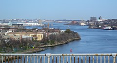
 Eastern part of Kill Van Kull


See also
- Port Richmond, Staten Island
- Port Johnston Coal Docks
- Geography of New York-New Jersey Harbor Estuary
- List of crossings of the Hackensack River
- List of crossings of the Lower Passaic River
- Sandy Hook Pilots
- Christopher O. Ward
References
- ISBN 978-0-88097-763-0.
- ^ Ports and waterways safety: Kill Van Kull Channel et al., NY and NJ, Federal Register, April 15, 1999 (Nbr. Vol. 64, No. 72)
- ^ Nadler: Kill Van Kull Fiasco Shows Red Hook’s Importance Archived October 9, 2009, at the Wayback Machine, Congressional Press Release
- ^ Kill Van Kull & Newark Bay Channel Deepening Archived July 14, 2009, at the Wayback Machine, Port Authority of New York and New Jersey, 30. April 1999
- ^ Corps Announces Start of Test Blasting Work for Kill Van Kull 50 Foot Deepening Archived November 29, 2010, at the Wayback Machine, U. S. Army Corps Of Engineers, Media Advisory, August 1, 2005
- ^ Shawn Boburg. $1B Bayonne Bridge Renovation Six Months Ahead of Schedule, Bergen County Record, July 19, 2012.
- ^ "Historical marker of Achter Col "colony"". Historical Marker Database. Retrieved September 2, 2010.
- ^ Grabas, Joseph A. "Land Speculation and Proprietary Beginnings of New Jersey" (PDF). The Advocate. XVI (4). New Jersey Land Title Association: 3, 20, 14. Archived from the original (PDF) on November 20, 2008. Retrieved April 15, 2010.
- Water upgrade for Kill Van Kull, Staten Island Advance, May 20, 2010
- New York Daily News articles re: Kill Van Kull
Bridges of the Newark Bay | ||||
|---|---|---|---|---|
| ||||
| International | |
|---|---|
| National | |
| Other | |