
Portal:East Sussex
The county has an area of 1,792 km2 (692 sq mi) and a population of 822,947. The latter is largely concentrated along the coast, where the largest settlements are located: Brighton and Hove (277,105), Eastbourne (99,180), and Hastings (91,490). The centre and north of the county are largely rural, and the largest settlement is Crowborough (21,990). For local government purposes, East Sussex comprises a non-metropolitan county, with five districts, and the unitary authority of Brighton and Hove. East Sussex and West Sussex historically formed a single county, Sussex.
East Sussex is part of the
Selected article
_(September_2018).JPG)
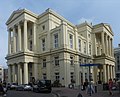
Brighton (/ˈbraɪtən/ BRY-tən) is a seaside resort and one of the two main areas of the city of Brighton and Hove in the county of East Sussex, England. It is located 47 miles (76 km) south of London. Archaeological evidence of settlement in the area dates back to the Bronze Age, Roman and Anglo-Saxon periods. The ancient settlement of "Brighthelmstone" was documented in the Domesday Book (1086). The town's importance grew in the Middle Ages as the Old Town developed, but it languished in the early modern period, affected by foreign attacks, storms, a suffering economy and a declining population. Brighton began to attract more visitors following improved road transport to London and becoming a boarding point for boats travelling to France. The town also developed in popularity as a health resort for sea bathing as a purported cure for illnesses.
In the
Brighton's location has made it a popular destination for tourists, renowned for its diverse communities, shopping areas, large and vibrant cultural, music and arts scene, and
Selected images
-
-

-

-

-

-

-
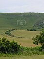
 Paragliders over the Litlington White Horse (from Portal:East Sussex/Selected pictures)
 -

-

-
 Credit: Ian Dunster(from Portal:East Sussex/Selected pictures)
Looking up at the East Hill Cliff Railway in Hastings, the steepest funicular railway in the country. -
 Mermaid Street in Rye showing typically steep slope and cobbled surface (from Portal:East Sussex/Selected pictures)
 -
 (from Portal:East Sussex/Selected pictures)More about the Kent & East Sussex Railway...


Oct2005.jpg)
Selected biography

Before joining the
Did you know that
General images -
-
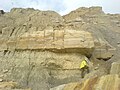
 Geology of south-eastern England. The Ashdown Sands and Wadhurst Clay is in lime green (9a); the Low Weald, darker green (9). Chalk Downs, pale green (6) (from Geology of East Sussex)
 -
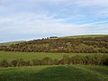
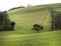 Sheep on Tegdown Hill (from Brighton and Hove)
 -
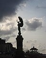 The Peace Statue on the seafront marks the border between Brighton and Hove (from Brighton and Hove)
 -
 Northeastward view along Hollingbury Crescent, Hollingdean (from Brighton and Hove)
 -
 This painting bygas masks. (from Seaford, East Sussex)
 -
 Happy Valley, Woodingdean (from Brighton and Hove)
 -
 Footpath towards Moulsecoomb Wild Park (from Brighton and Hove)
 -
 Ewe Bottom from the Sussex Border Path (from Brighton and Hove)
 -
 Seaford Beach with Seaford Head in the background. (from Seaford, East Sussex)
 -
 Varncombe Hill (from Brighton and Hove)
 -
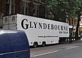 The Glyndebourne on Tour trailer (from Glyndebourne Festival Opera)
 -
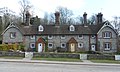 Stanmer Village (from Brighton and Hove)
 -
 Geological section from north to south (from Geology of East Sussex)
 -
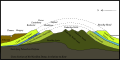
 Cross section view of Southern England featuring the Weald Basin (from Geology of East Sussex)
 -
 Brighton Town Hall at Bartholomews in The Lanes (from Brighton and Hove)
 -
 Hangleton in the snow (from Brighton and Hove)
 -
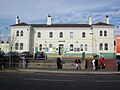 Portslade Station (from Brighton and Hove)
 -
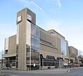 Hove Town Hall on Church Road (from Brighton and Hove)
 -
 Sweet Hill, near Patcham, Brighton, The old farm house (from Brighton and Hove)
 -
 Corporate logo of the council (from Brighton and Hove)
 -
 The council is currently composed of 38 Labour, 7 Green, 6 Conservative and 3 independent councillors (from Brighton and Hove)
 -
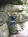 Climber enjoying the )
 -
 Chattri Brighton from the West (from Brighton and Hove)
 -
-
 Westward view across Brighton from Whitehawk Hill (from Brighton and Hove)
 -
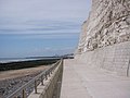 Undercliff path East of Brighton (from Brighton and Hove)
 -
 St Wulfran, Ovingdean (from Brighton and Hove)
 -
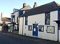 The Old Town Hall (from Seaford, East Sussex)
 -
 Glyndebourne House, 1 August 2006 (from Glyndebourne Festival Opera)
 -
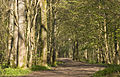
 Bridleway, Falmer Hill (from Brighton and Hove)
 -
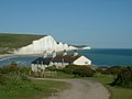 TheSeven Sisters chalk cliffs to the east of Seaford (from Seaford, East Sussex)
 -
 Brighton and Hove downland and seafront (from Brighton and Hove)
 -
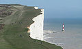
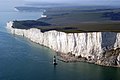 Beachy Head from the air, with Beachy Head Lighthouse at its foot. (from Beachy Head)
 -
 Electricity Pylons on Cockroost Hill (from Brighton and Hove)
 -
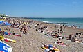 Brighton beach (from Brighton and Hove)
 -
 Trigpoint on the approach to Mount Zion (from Brighton and Hove)
 -
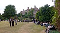
 Stanmer Park (from Brighton and Hove)
 -
 Sheepcote Valley (from Brighton and Hove)
 -
 The Patcham Pylons mark the border of Brighton and Hove on the A23 (from Brighton and Hove)
 -
-
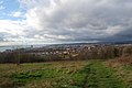
 View from Hollingbury Hill, Brighton (from Brighton and Hove)
 -
 Looking towards the cliffs and lighthouse from the west nearBirling Gap. (from Beachy Head)
 -
 Northward view along Warmdene Road, Patcham (from Brighton and Hove)
 -
 Bevendean Down (Local Nature Reserve) (from Brighton and Hove)
 -
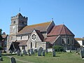 St Leonard's Church, in the town centre, has 11th-century origins. (from Seaford, East Sussex)
 -
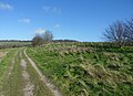
 Track at The Bostle (from Brighton and Hove)
 -
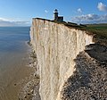 Belle Tout Lighthouse (from Beachy Head)
 -
 Southwestward view along Ladies Mile, Patcham (from Brighton and Hove)
 -
 Population pyramid of Brighton and Hove in 2021 (from Brighton and Hove)
 -
 1–14 Chichester Terrace, Kemp Town (from Brighton and Hove)
 -
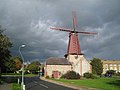 West Blatchington windmill (from Brighton and Hove)
 -
 Cockroost Bottom (from Brighton and Hove)
 -
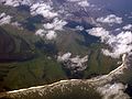 Aerial view of Beachy Head, with Eastbourne visible at the top of the photo. (from Beachy Head)
 -
 Phone box and sign advertising the Samaritans at Beachy Head. (from Beachy Head)


_(2).JPG)


.jpg)


_(April_2013).JPG)

_(July_2014)_(1).jpg)


_(2).JPG)


_(1).JPG)


.jpg)


.jpg)


,_Patcham_(from_SW).jpg)

_(10).JPG)

.JPG)
,_Bevendean_(May_2020)_(6).JPG)
.jpg)


.JPG)

_(September_2018)_(2).jpg)


List articles

- List of hills of East Sussex
- List of local nature reserves in East Sussex
- List of monastic houses in East Sussex
- List of museums in East Sussex
- List of Parliamentary constituencies in East Sussex
- List of places in East Sussex
- List of settlements in East Sussex by population
- List of Sites of Special Scientific Interest in East Sussex
- List of windmills in East Sussex
Subcategories

Settlements map
Things you can do
- Add to this portal.
- Join the Sussex WikiProject
Topics
Related portals
Associated Wikimedia
The following Wikimedia Foundation sister projects provide more on this subject:
-
 Commons
Free media repository -
 Wikibooks
Free textbooks and manuals -
 Wikidata
Free knowledge base -
 Wikinews
Free-content news -
 Wikiquote
Collection of quotations -
 Wikisource
Free-content library -
 Wikiversity
Free learning tools -
 Wikivoyage
Free travel guide -
 Wiktionary
Dictionary and thesaurus


