
Quetta
Quetta
| ||
|---|---|---|
|
Dialing code 081 | | |
| Website | www | |


Quetta (
Located in northern
Etymology
The name Quetta is a variation of the
History
-
 Quetta Fort Mirri
 -
 Fort Mirri in 1880
 -
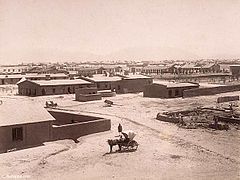 Quetta Cantonment, 1889


The immediate area has long been one of pastures and mountains, with varied
From 11th century, the land of Quetta was owned and ruled by the Kasi Pashtun tribe. It was captured by
In 1876, Quetta was occupied by the British and subsequently incorporated into

By the time of the earthquake on 31 May 1935, Quetta had developed into a bustling city with a number of skyscraper buildings and so was known as "Little London".[citation needed] The epicentre of the earthquake was close to the city and destroyed most of the city's infrastructure, killing an estimated 40,000 people.[11]
Geography
Climate
Quetta has a
| Climate data for Quetta (1991-2020) | |||||||||||||
|---|---|---|---|---|---|---|---|---|---|---|---|---|---|
| Month | Jan | Feb | Mar | Apr | May | Jun | Jul | Aug | Sep | Oct | Nov | Dec | Year |
| Record high °C (°F) | 23.6 (74.5) |
26.7 (80.1) |
31.1 (88.0) |
35.0 (95.0) |
39.4 (102.9) |
41.5 (106.7) |
42.0 (107.6) |
40.6 (105.1) |
38.3 (100.9) |
34.0 (93.2) |
36.0 (96.8) |
25.0 (77.0) |
42.0 (107.6) |
| Mean daily maximum °C (°F) | 11.8 (53.2) |
14.0 (57.2) |
19.5 (67.1) |
25.9 (78.6) |
31.4 (88.5) |
35.5 (95.9) |
36.8 (98.2) |
35.4 (95.7) |
31.9 (89.4) |
26.0 (78.8) |
19.6 (67.3) |
14.6 (58.3) |
25.2 (77.4) |
| Daily mean °C (°F) | 4.8 (40.6) |
7.1 (44.8) |
12.5 (54.5) |
17.9 (64.2) |
23.0 (73.4) |
27.3 (81.1) |
29.2 (84.6) |
27.5 (81.5) |
22.8 (73.0) |
16.5 (61.7) |
11.0 (51.8) |
6.5 (43.7) |
17.2 (62.9) |
| Mean daily minimum °C (°F) | −1.9 (28.6) |
0.3 (32.5) |
5.1 (41.2) |
10.0 (50.0) |
14.6 (58.3) |
19.0 (66.2) |
21.6 (70.9) |
19.7 (67.5) |
13.6 (56.5) |
7.0 (44.6) |
1.9 (35.4) |
−1.4 (29.5) |
9.1 (48.4) |
| Record low °C (°F) | −18.3 (−0.9) |
−16.7 (1.9) |
−8.3 (17.1) |
−3.9 (25.0) |
−0.3 (31.5) |
5.0 (41.0) |
8.9 (48.0) |
3.3 (37.9) |
−0.6 (30.9) |
−8.3 (17.1) |
−13.3 (8.1) |
−18.3 (−0.9) |
−18.3 (−0.9) |
| Average precipitation mm (inches) | 45.0 (1.77) |
48.4 (1.91) |
49.5 (1.95) |
30.0 (1.18) |
7.8 (0.31) |
3.2 (0.13) |
8.8 (0.35) |
4.9 (0.19) |
4.2 (0.17) |
4.5 (0.18) |
10.3 (0.41) |
24.6 (0.97) |
241.2 (9.52) |
| Average snowfall cm (inches) | 22 (8.7) |
17 (6.6) |
3.0 (1.2) |
0 (0) |
0 (0) |
0 (0) |
0 (0) |
0 (0) |
0 (0) |
0 (0) |
0.51 (0.2) |
14 (5.4) |
56.51 (22.1) |
| Average precipitation days (≥ 1.0 mm) | 5.0 | 5.7 | 5.4 | 4.1 | 1.7 | 0.7 | 0.8 | 0.8 | 0.4 | 0.6 | 1.7 | 2.7 | 29.6 |
| Mean monthly sunshine hours | 220.1 | 209.05 | 232.5 | 273.0 | 334.8 | 327.0 | 313.1 | 313.1 | 294.0 | 306.9 | 279.0 | 238.7 | 3,341.25 |
| Source 1: NOAA,[13] Hong Kong Observatory (altitude: 1589 m) (only snow inch, sun)[14] | |||||||||||||
| Source 2: PMD[15] | |||||||||||||
The city saw a severe drought from 1999 to 2001 during which the city did not receive snowfall and below normal rains. In 2002, the city received snow after a gap of five years. In 2004 and 2005, the city received normal rains after three years without snowfall while in 2006, 2007 and 2009 the city received no snow. In 2008, it received a snowfall of 10 centimetres (4 in) in four hours on 29 January,
Demographics
| Year | Pop. | ±% |
|---|---|---|
| 1941 | 65,000 | — |
| 1951 | 84,000 | +29.2% |
| 1961 | 107,000 | +27.4% |
| 1972 | 158,000 | +47.7% |
| 1981 | 286,000 | +81.0% |
| 1998 | 565,137 | +97.6% |
| 2017 | 1,001,205 | +77.2% |
| Source: [18][3] | ||
The population of the city is around one million. In 2016, it was estimated at 1,140,000,
According to Reuters and the BBC, there are as many as 500,000-600,000 Hazaras living in Quetta and its surrounding areas.[24][25]
| Religious group |
1941[26]: 13–14 | 2017[27][28] | ||
|---|---|---|---|---|
| Pop. | % | Pop. | % | |
| Islam |
27,935 | 43.33% | 975,815 | 97.64% |
| Hinduism |
24,010 | 37.24% | 6,112 | 0.61% |
| Sikhism |
7,364 | 11.42% | — | — |
| Christianity |
5,024 | 7.79% | 16,842 | 1.69% |
| Zoroastrianism |
73 | 0.11% | — | — |
| Buddhism |
42 | 0.07% | — | — |
| Judaism |
11 | 0.02% | — | — |
| Jainism |
6 | 0.01% | — | — |
| Ahmadiyya |
— | — | 363 | 0.04% |
| Others | 11 | 0.02% | 253 | 0.03% |
| Total population | 64,476 | 100% | 999,385 | 100% |
Administration
At the local level, the city is governed by a municipal corporation consisting of 66 ward members which elects a mayor and a deputy mayor.[1] In addition, Quetta Development Authority is responsible for provision of municipal services for the city.[29]
Transportation


Quetta is on the western side of Pakistan and is connected to the rest of the country by a network of roads, railways and its international airport close to its centre.
At an altitude of 1,605 metres (5,266 feet) above sea level, Quetta International Airport is the second highest airport in Pakistan.[30] Pakistan International Airlines has regular flights to and from the other major cities of Pakistan including Islamabad, Gwadar, Karachi, Lahore and Peshawar.
Education
Quetta serves as the learning centre for the Balochistan province. The city has a number of government and private colleges, including the following:
- Balochistan Agriculture College
- Balochistan University of Information Technology, Engineering and Management Sciences(BUITEMS)
- Bolan Medical College
- Pakistan Command and Staff College
- Sardar Bahadur Khan Women's University
- St Francis Grammar School
- St. Joseph's Convent School, Quetta
- Government Science College, Quetta
- Tameer-e-Nau Public College
- University Law College, Quetta
- University of Balochistan
Sports

Bugti Stadium is the home of Balochistan cricket team, a first-class cricket team which competes in domestic tournaments,[33] and the Quetta based team Quetta Gladiators compete in the Pakistan Super League (PSL). They were the champion of the PSL 2019.
Boxing is highly popular as well.[34] Muhammad Waseem is a professional boxer from Quetta. In Body Building Nisar Ahmed Khilji has Mr. Balochistan and Mr. Pakistan Titles and Pakistan representation in International Body Building Contests. In hockey, Quetta has produced Zeeshan Ashraf and Shakeel Abbasi, who were members of the Pakistan's national hockey team.
Facilities

The Shaheed Nauoroz Stadium is the largest stadium in the city. The city also has Ayub National Stadium, a multipurpose stadium used for football and cricket and Bugti Stadium for cricket.
Local facilities were created in the city for
Twin towns and sister cities
Gallery
-
 Junior officers in a tactical discussion at the Infantry School, Quetta
 -
-
 Askari Park
 -
 Quetta Cantonment
 -
 Quetta in 1880


See also
- 2008 Ziarat earthquake
- List of people from Quetta
- Balochi cuisine
- Quetta hut
- RMS Quetta
- Quetta Memorial Precinct
- Governor's House, Quetta
Notes
References
- ^ a b "Government Organization – Government of Balochistan". balochistan.gov.pk. Retrieved 6 September 2016.
- ^ a b "Quetta sit-in continues as talks break down". Daen (newspaper). 13 December 2023. Retrieved 19 December 2023.
- ^ a b DISTRICT WISE CENSUS RESULTS CENSUS 2017 (PDF) (Report). Pakistan Bureau of Statistics. 2017. p. 13. Archived from the original (PDF) on 29 August 2017. Retrieved 29 March 2018.
- ^ "Mongabay -environmental science and conservation news". Archived from the original on 4 March 2016.
- Bol News. 18 January 2020. Retrieved 7 January 2022.
- ISBN 978-0-19-188291-3, retrieved 4 September 2021
- ^ Thornton, Thomas Henry (1895). Colonel Sir Robert Sandeman: His Life and Work on Our Indian Frontier. A Memoir, with Selections from His Correspondence and Official Writings. J. Murray.
- ^ ISBN 9781442241480.
- ^ "History of District". bhc.gov.pk. Retrieved 26 November 2017.
- ^ Dodwell, H. H. (1929). The Cambridge History of the British Empire. CUP Archive.
- ^ ڈان اردو (30 December 2013). "پاکستانی شہروں کی تاریخ". dawnnews.tv. Retrieved 26 February 2016.
- ^ a b c d "Mean FOR THE PERIOD 1961 – 2009". Karachi: Climate Data Processing Centre (CDPC), Pakistan Meteorological Department. Archived from the original on 13 June 2010.
- ^ "Quetta Climate Normals 1991–2020". World Meteorological Organization Climatological Standard Normals (1991–2020). National Oceanic and Atmospheric Administration. Retrieved 17 September 2023.
- ^ "Climatological Information for Quetta, Pakistan". Hong Kong Observatory. Archived from the original on 16 June 2018. Retrieved 3 December 2019.
- ^ "Extremes of Quetta". Pakistan Meteorological Department. Retrieved 3 February 2015.
- ^ "Cold wave intensifies with heavy snowfall". Dawn. 29 January 2008. Archived from the original on 4 January 2009.
- ^ "Leading News Resource of Pakistan". Daily Times. 4 February 2008. Retrieved 8 May 2012.
- ^ Elahi, Asad (2006). "2: Population". Pakistan Statistical Pocket Book 2006. Islamabad, Pakistan: Government of Pakistan: Statistics Division. p. 28. Archived from the original (PDF) on 30 March 2018. Retrieved 29 March 2018.
- ^ "Demographics" (PDF). www.demographia.com. Archived (PDF) from the original on 30 March 2004. Retrieved 16 March 2020.
- ^ Jonah Blank, Christopher Clary & Brian Nichiporuk 2014.
- ISBN 978-1-74104-542-0.
- ^ "The Crowded-Out Conflict by Ann Wilkens – Pashtun form the Majority".
- ISBN 978-1-84904-292-5.
- ^ "Two killed in sectarian attack in southwestern Pakistan". Reuters. 22 April 2018.
- ^ Kermani, Secunder (12 December 2017). "The community caged in its own city". BBC News.
- ^ a b "Census of India, 1941 Volume XIV Baluchistan". Retrieved 27 January 2023.
- ^ "Final Results (Census-2017)". Retrieved 27 January 2023.
- ^ "District Wise Results / Tables (Census - 2017) TABLE 9 - POPULATION BY SEX, RELIGION AND RURAL/URBAN" (PDF). Retrieved 27 January 2023.
- ^ "About QDA – Quetta Development Authority".
- ^ Quetta Airport Archived 29 June 2009 at the Wayback Machine CAA Pakistan. Retrieved 24 June 2009
- ^ "Bomb attack targets Worshippers at Quetta mosque, killing 14". www.aljazeera.com.
- ^ Javed Haider Sayed (2008). "The Balochistan Muslim League". National Institute of Historical & Cultural Research – Pakistan. Quaid-e-Azam University, Islamabad. Retrieved 6 March 2016.[permanent dead link]
- ^ "PCB unveils new domestic set-up with 'stay at the top' mantra". ESPN Cricinfo.
- ^ Faruqi, Sama. "The Hazaras who made Quetta a boxing powerhouse". The Caravan. Retrieved 7 December 2019.
Bibliography
- Bosworth, C.E. (1986). "Kwat́́t́́a". In ISBN 978-90-04-07819-2.
- Jonah Blank; Christopher Clary; Brian Nichiporuk (30 October 2014), Drivers of Long-Term insecurity and Instability in Pakistan: Urbanization, Rand Corporation, p. 29, ISBN 978-0-83-308751-5
External links
- Balochistan Board Archived 22 January 2015 at the Wayback Machine
- Official webpage on Balochistan.gov.pk (archived 18 October 2010)
|  | |||
Cities |
| |||
| Towns and councils | ||||
| Localities | ||||
Website: Quetta District at NRB | ||||
Provincial capital: Quetta | ||
| Kalat |  | |
| Makran | ||
| Nasirabad | ||
| Quetta | ||
| Sibi | ||
| Zhob | ||
| Rakhshan | ||
| Loralai | ||
a - formerly part of Quetta Division; b - formerly part of Kalat Division; c - formerly part of Zhob Division | ||
Largest cities or towns in Balochistan, Pakistan | |||||||||||||||||||||||||||||||||||||||||||||||||||||||||
|---|---|---|---|---|---|---|---|---|---|---|---|---|---|---|---|---|---|---|---|---|---|---|---|---|---|---|---|---|---|---|---|---|---|---|---|---|---|---|---|---|---|---|---|---|---|---|---|---|---|---|---|---|---|---|---|---|---|
| |||||||||||||||||||||||||||||||||||||||||||||||||||||||||


| International | |
|---|---|
| National | |