
Ryck
| Ryck | |
|---|---|
 Ryck river near Greifswald-Wieck | |
| Location | |
| Country | Germany |
| State | Mecklenburg-Vorpommern |
| Region | Western Pomerania |
| Physical characteristics | |
| Source | |
| • location | Süderholz near Grimmen |
| • elevation | near zero |
| Mouth | |
• location | Baltic Sea: Bay of Greifswald at Greifswald-Wieck |
| Length | ±28 km (17 mi) |
| Basin size | 23.4 ha (58 acres) |
The Ryck is a river in Mecklenburg-Vorpommern, Germany.
From its source near
hypersaline water of the Baltic Sea
is driven into the river by the wind, flooding the lower meadows on the Ryck's northern bank.
In the High Middle Ages, the Ryck marked the southern border of the Principality of Rügen and the northern border of the County of Gützkow. West of Greifswald, the Ryck fed the Boltenhägener Teich, a medieval lake.
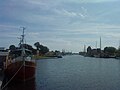
The old Hanseatic port in Greifswald is now an open-air ship museum.
-
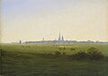 "Meadows near Greifswald" Caspar David Friedrich, 1820 (depicting the area used for salt evaporation)
 -
 Old port, downtown Greifswald, view from Steinbecker bridge
 -
 Old port, downtown Greifswald, view from pedestrians' bridge
 -
 Old bridge in Greifswald-Wieck
 -
 Mouth at Greifswald-Wieck
 -
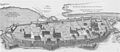 Map of medieval Greifswald showing Boltenhäg(en)er Teich and the confluence of the Baberow, neither of which now exist.
_-_Caspar_David_Friedrich_(Hamburger_Kunsthalle).jpg)


.jpg)