
Crimea: Difference between revisions
No edit summary |
|||
| Line 299: | Line 299: | ||
* [[Belarusians]]: 35,000 (1.4%), |
* [[Belarusians]]: 35,000 (1.4%), |
||
* [[Volga Tatars]]: 13,500 (0.5%), |
* [[Volga Tatars]]: 13,500 (0.5%), |
||
* [[Armenians]]: 10,000 (0.4%) |
* [[Armenians]]: 10,000 (0.4%). |
||
* [[Jews]]: 5,500 (0.2%).<ref name="census">this combines the figures for the Autonomous Republic of Crimea and Sevastopol, listing groups of more than 5,000 individuals. {{cite web|url=http://2001.ukrcensus.gov.ua/eng/results/general/nationality/Crimea/ |title= Autonomous Republic of Crimea |accessdate=2014-03-24 |work=[[Ukrainian Census (2001)|2001 Ukrainian Census]]}}; {{cite web|url=http://2001.ukrcensus.gov.ua/eng/results/general/nationality/Sevastopol/|title=Sevastopol|work=[[Ukrainian Census (2001)|2001 Ukrainian Census]]|accessdate=2014-03-24}}</ref> |
|||
According to the 2001 census, 77% of Crimean inhabitants named [[Russian language in Ukraine|Russian]] as their native language; 11.4% – Crimean Tatar; and 10.1% – Ukrainian.<ref>{{cite web|url=http://2001.ukrcensus.gov.ua/eng/results/general/language/Crimea/ |title= Results / General results of the census / Linguistic composition of the population / Autonomous Republic of Crimea |work=[[Ukrainian Census (2001)|2001 Ukrainian Census]] }}</ref> |
According to the 2001 census, 77% of Crimean inhabitants named [[Russian language in Ukraine|Russian]] as their native language; 11.4% – Crimean Tatar; and 10.1% – Ukrainian.<ref>{{cite web|url=http://2001.ukrcensus.gov.ua/eng/results/general/language/Crimea/ |title= Results / General results of the census / Linguistic composition of the population / Autonomous Republic of Crimea |work=[[Ukrainian Census (2001)|2001 Ukrainian Census]] }}</ref> |
||
Revision as of 09:24, 10 October 2014
Template:Three other uses 45°18′N 34°24′E / 45.3°N 34.4°E
 | |
| Geography | |
|---|---|
| Location | Eastern Europe |
| Coordinates | 45°18′N 34°24′E / 45.3°N 34.4°E |
| Adjacent to | |
| Largest city | Sevastopol |
| Area | 27,000 km2 (10,000 sq mi) |
| Highest elevation | 1,545 m (5069 ft) |
| Administration | |
Crimean | |
| Population | 2.4 million[citation needed] |

The Crimean Peninsula (
Crimea—or the .
Crimea and adjacent territories were united in the Crimean Khanate during the 15th to 18th century before falling to the Russian Empire and being organised as its Taurida Oblast in 1783.
After the
Sovereignty and control of the peninsula became the subject of the ongoing
Name
The classical name
In English, the Crimean Khanate is referred to as Crim Tartary in the early modern period.[3] The Italian[4] form Crimea (and "Crimean peninsula") also becomes current during the 18th century,[5] gradually replacing the classical name of Tauric peninsula in the course of the 19th century. The omission of the definite article in English ("Crimea" rather than "the Crimea") becomes common during the later 20th century.
The name "Crimea" ultimately, via Italian, takes its origin with the name of Qırım (today's
- a corruption of Cimmerium.[7]
- a derivation from the Greek Cremni (κρήμνοι kremnoi "cliffs", mentioned in Herodotus 4.20).
- a derivation from the Mongolian appellation[8] kerm designating "wall", which, however, is phonetically incompatible with the original Mongolian literal appellation of the Crimean peninsula Qaram,[9]
- a derivation from the Crimean Tatar Turkic appellation Qırım designating "fortress" or "fosse", from the Turkic term qurum ("defense, protection"), qurimaq ("to fence, protect").[9][10][11]
The classical name was revived in the name of the Russian Taurida Governorate.[12] While it was abandoned in the Soviet Union, and has had no official status since 1921, it is still used by some institutions in Crimea, such as the
History

In ancient times, it was the home of
Later occupiers included the
In the 9th century CE, Byzantium established the

The
During the
In 1954, it was transferred to the Ukrainian Soviet Socialist Republic within the Soviet Union.[15] In 1991, it became part of independent Ukraine as the Autonomous Republic of Crimea.
As a result of the events called as
Events of 2014 are described in detail in the following articles:
- Autonomous Republic of Crimea
- Crimean crisis
- Crimean status referendum, 2014
- Russian military intervention
- Annexation of Crimea by the Russian Federation
- Republic of Crimea
- International sanctions during the 2014 pro-Russian unrest in Ukraine
Geography
Covering an area of 27,000 km2 (10,425 sq mi)*, Crimea is located on the northern coast of the Black Sea and on the western coast of the Sea of Azov, the only land boarder is shared with Ukraine's Kherson Oblast from the north.
The natural border between the Crimean Peninsula and the Ukrainian mainland is formed by the
Geographically, the peninsula is generally divided into three zones:
Coastline

The Crimean peninsula comprises many smaller peninsulas, such as the mentioned
, and many others.The Crimean coastline is broken by several bays and harbors. These harbors lie west of the Isthmus of Perekop by the Bay of Karkinit; on the southwest by the open Bay of Kalamita between the port cities of Eupatoria and Sevastopol.
The
Crimean Mountains

The southeast coast is flanked at a distance of 8–12 kilometres (5.0–7.5 mi) from the sea by a parallel range of mountains, the Crimean Mountains.[17] These mountains are backed by secondary parallel ranges.
The main range of these mountains shoots up with extraordinary abruptness from the deep floor of the
Steppe
Seventy-five percent of the remaining area of Crimea consists of semiarid
Crimean Riviera

The terrain that lies beyond the sheltering Crimean Mountain range is of an altogether different character. Here, the narrow strip of coast and the slopes of the mountains are smothered with greenery. This "riviera" stretches along the southeast coast from capes
Climate
Most of Crimea has a temperate continental climate, except for the south coast where it experiences a humid subtropical climate[citation needed], due to warm influences from the Black Sea and the high ground of the Crimean Mountains. Summers can be hot (28 °C or 82.4 °F July average) and winters are cool (−0.3 °C or 31.5 °F January average) in the interior, on the south coast winters are milder (4 °C or 39.2 °F January average) and temperatures much below freezing are exceptional. On the high ground, freezing weather is common in winter. Precipitation throughout Crimea is low, averaging only 400 mm (15.7 in) a year. The Crimean coast is shielded from the north winds by the mountains, and as a result usually has mild winters. Cool season temperatures average around 7 °C (44.6 °F) and it is rare for the weather to drop below freezing except in the mountains, where there is usually snow.[19] Because of its climate, the southern Crimean coast is a popular beach and sun resort for Ukrainian and Russian tourists.
Strategic value
The
The
According to the International Transport Workers' Federation, in 2013 there were at least 12 operating merchant seaports in Crimea.[22]
Within 200 nautical miles of the Crimean shoreline there are an estimated 45 trillion cubic meters of gas reserves.[23] Hydrocarbons in the Black Sea shelf could yield as much as 1.5 billion cubic meters per year.[24]
Economy
This section is missing information about Crimea's GDP distribution by economic sector. (March 2014) |

The main branches of the modern Crimean economy are tourism and agriculture.[
The most important industries in Crimea include food production, chemical fields, mechanical engineering and metal working, and fuel production industries.[25] Sixty percent of the industry market belongs to food production. There are a total of 291 large industrial enterprises and 1002 small business enterprises.[25]
Agriculture in the region includes cereals, vegetable-growing, gardening, and wine-making, particularly in the Yalta and Massandra regions. Livestock production includes cattle breeding, poultry keeping, and sheep breeding.[25] Other products produced on the Crimean Peninsula include salt, porphyry, limestone, and ironstone (found around Kerch) since ancient times.[26]
Energy
Crimea also possesses several
| Name | Type | Location | Reserves |
|---|---|---|---|
| Dzhankoyske gas field | onshore | Dzhankoy
|
|
Golitsyna gas field
|
offshore | Black Sea | |
| Karlavske gas field | onshore | Chornomorske | |
| Krym gas field | offshore | Black Sea | |
Odessa gas field[30]
|
offshore | Black Sea | 21 billion m3 |
| Schmidta gas field | offshore | Black Sea | |
Shtormvaya gas field
|
offshore | Black Sea | |
| Strilkove gas field | offshore | Sea of Azov |
The republic also possesses two
Infrastructure
This section lacks an overview of its topic. (March 2014) |


- Public transportation
Almost every settlement in Crimea is connected with another settlement with bus lines. Crimea contains the longest (96 km or 59 mi) trolleybus route in the world, stretching from Simferopol to Yalta.[31] The trolleybus line starts near Simferopol's Railway Station through the mountains to Alushta and on to Yalta. The length of line is about 90 km. It was founded in 1959.
- Highways
- (ends)
- , ends)
- H05 – Krasnoperekopsk, Simferopol (access to the Simferopol International Airport)
- H06 – Bakhchisaray, Sevastopol
- H19 – Yalta, Sevastopol
- P16
- P23 – Feodosiya
- P25 – Simferopol, Yevpatoria
- P27 – Sevastopol, Inkerman (completely within the city of Sevastopol)
- P29 – Feodosiya
- P34 – Alushta, Yalta
- P35 – Hrushivka, Sudak
- P58 – Sevastopol, Port "Komysheva Bukhta" (completely within the city of Sevastopol)
- P59 (completely within the city of Sevastopol)
- Sea transport
The cities of Yalta,
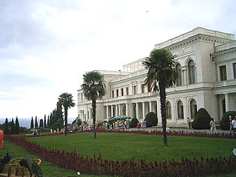
Tourism
.jpg)

The development of Crimea as a holiday destination began in the second half of the 19th century. The development of the transport networks brought masses of tourists from central parts of the Russian Empire. At the beginning of the 20th century, a major development of palaces, villas, and dachas began—most of which remain. These are some of the main attractions of Crimea as a tourist destination. There are many Crimean legends about famous touristic places, which attract the attention of tourists.
A new phase of tourist development began when the Soviet government realized the potential of the healing quality of the local air, lakes and therapeutic muds. It became a "health" destination for Soviet workers, and hundreds of thousands of Soviet tourists visited Crimea.
In the 1990s, Crimea became more of a get-away destination than a "health-improvement" destination. The most visited areas are the south shore of Crimea with cities of Yalta and Alushta, the western shore - Eupatoria and Saki, and the south-eastern shore - Feodosia and Sudak. According to National Geographic, Crimea was among the top 20 travel destinations in 2013.[34]
Crimea possesses significant historical and natural resources and is a region where it is possible to find practically any type of landscape; mountain ranges and plateaus, grasslands, caves. Furthermore, Saki poses unique therapeutic mud and Eupatoria has vast empty beaches with the purest sand.[35]
Places of interest include
Demographics
As of 2007, the estimate of the total population of the Autonomous Republic of Crimea and Sevastopol was at 2.352 million people,[36] just slightly down from the count of the

The ethnic makeup of the population is comprised the following self-reported groups (
- Russians:1,450,000 (58.5%),
- Ukrainians: 577,000 (24.0%),
- Crimean Tatars: 245,000 (10.2%),
- Belarusians: 35,000 (1.4%),
- Volga Tatars: 13,500 (0.5%),
- Armenians: 10,000 (0.4%).
According to the 2001 census, 77% of Crimean inhabitants named Russian as their native language; 11.4% – Crimean Tatar; and 10.1% – Ukrainian.[38]
Ethnic composition of Crimea's population has changed dramatically since the early 20th century. The 1897
| Ethnic group |
1939 census | 1959 census[citation needed] | 1979 census | 1989 census[41] | 2001 census[41]
| |||||||
|---|---|---|---|---|---|---|---|---|---|---|---|---|
| Number | % | Number | % | Number | % | Number | % | Number | % | Number | % | |
| Russians | 181,000 | 33.11% | 49.6% | 71.4% | 68.4% | 65.6% | 1,180,441 | 58.5% | ||||
| Ukrainians | 64,643 | 11.83% | 13.7% | 22.3% | 25.6% | 26.7% | 492,227 | 24.4% | ||||
| Crimean Tatars | 194,383 | 35.56% | 19.4% | 0% | 0.7% | 1.9% | 243,433 | 12.1% | ||||
| Others | ||||||||||||
Jews in Crimea were historically Krymchaks and Karaites (the latter a small group centered at Yevpatoria). The 1879 census for the Taurida Governorate reported a Jewish population of 4.20%, not including a Karaite population of 0.43%. The Krymchaks (but not the Karaites) were targeted for annihilation during Nazi occupation.
The number of
Besides the Crimean Germans, Stalin in 1944 also deported 70,000 Greeks, 14,000 Bulgarians[48] and 3,000 Italians.
Culture

Ivan Aivazovsky, the 19th century marine painter of Armenian origin, who is considered one of the major artists of his era was born in Feodosia and lived there for the most part of his life. Many of his paintings depict the Black Sea. He also created battle paintings during the Crimean War.[49]
Almost 100 broadcasters and around 1,200 publications are registered in Crimea, although no more than a few dozen operate or publish regularly.[50] Of them most use the Russian language only.[50] Crimea's first Tatar-owned, Tatar-language TV launched in 2006.[50]
Crimea was the background for
-
 Painting of the Russian squadron in Sevastopol by Ivan Aivazovsky (1846)
 -
 The grave of Russian poet and artist Maximilian Voloshin
 -
 People at theKazantipmusic festival in 2007
.JPG)


Gallery
-
 Bakhchisaray Palace
 -
 Dulber Palace in Koreiz
 -
 Vorontsov Palace
 -
-
 Catholic church in Yalta
 -
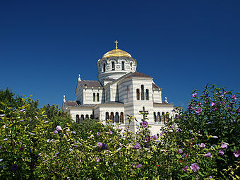 St. Vladimir's Cathedral, dedicated to the Heroes of Sevastopol (Crimean War).


See also
References
- ^ "Treaty to accept Crimea, Sevastopol to Russian Federation signed". rt.com. Autonomous Nonprofit Organization “TV-Novosti”. March 18, 2014. Retrieved 24 March 2014.
- ^ An universal history, from the earliest accounts to the present time, vol. 9 (1779), p. 127.
- ^ Edward Gibbon, The History of the Decline and Fall of the Roman Empire, Volume 1, 306f. "the peninsula of Crim Tartary, known to the ancients under the name of Chersonesus Taurica"; ibid. Volume 10 (1788), p. 211: "The modern reader must not confound this old Cherson of the Tauric or Crimean peninsula with a new city of the same name". see also John Millhouse, English-Italian (1859), p. 597
- ^ la Crimea since at least the 17th century. Maiolino Bisaccioni, Giacomo Pecini, Historia delle guerre ciuili di questi vltimi tempi, cioe, d'Inghilterra, Catalogna, Portogallo, Palermo, Napoli, Fermo, Moldauia, Polonia, Suizzeri, Francia, Turco. per Francesco Storti. Alla Fortezza, sotto il portico de'Berettari, 1655, p. 349: "dalla fortuna de Cosacchi dipendeva la sicurazza della Crimea". Nicolò Beregani, Historia delle guerre d'Europa, Volume 2 (1683), p. 251.
- ^ J. Dodsley, The annual register or a view of the history, politics, and literature for the year 1783 (1785), p. 364.
- ^ W. Radloff, Versuch eines Wörterbuches der Türk-Dialecte (1888), ii. 745
- Encyclopedia Britannica4th edition (1810).Alexander MacBean, Samuel Johnson, Cimmeriumin A Dictionary of Ancient Geography (1773).
- ^ Adrian Room, Placenames of the World, 2003, p. 96. Asimov, Isaac (1991). Asimov's Chronology of the World. New York: HarperCollins. p. 50.. See also William Smith, Dictionary of Greek and Roman Geography, 1854
- ^ a b Edward Allworth, The Tatars of Crimea: Return to the Homeland : Studies and Documents, Duke University Press, 1998, pp. 5-7
- ^ George Vernadsky, Michael Karpovich, A History of Russia, Yale University Press, 1952, p. 53. Quote:
- "The name Crimea is to be derived from the Turkish word qirim (hence the Russian krym), which means "fosse" and refers more specifically to the Perekop Isthmus, the old Russian word perekop being an exact translation of the Turkish qirim."
- ^ Jews in Byzantium: Dialectics of Minority and Majority Cultures, BRILL, 2011, p.753
- ^ Edith Hall, Adventures with Iphigenia in Tauris (2013), p. 176: "it was indeed at some point between the 1730s and the 1770s that the dream of recreating ancient 'Taurida' in the southern Crimea was conceived. Catherine's plan was to create a paradisiacal imperial 'garden' there, and her Greek archbishop Eugenios Voulgaris obliged by inventing a new etymology for the old name of Tauris, deriving it from taphros, which (he claimed) was the ancient Greek for a ditch dug by human hands."
- The Jamestown Foundation. p. 27.
- ^ Darjusz Kołodziejczyk, as reported by Mikhail Kizilov (2007). "Slaves, Money Lenders, and Prisoner Guards: The Jews and the Trade in Slaves and Captivesin the Crimean Khanate". The Journal of Jewish Studies. p. 2.
- ^ "Ukraine and the west: hot air and hypocrisy". The Guardian. March 10, 2014.
- ^ "Crimean Parliament adopted the Declaration of independence of ARC and Sevastopol". http://www.rada.crimea.ua/. 11 March 2014. Retrieved 2014-11-03.
{{cite web}}: External link in|publisher= - ^ The Crimean Mountains may also be referred to as the Yaylâ Dağ or Alpine Meadow Mountains.
- ^ See the article "Crimea" in the Encyclopædia Britannica Eleventh Edition.
- ^ "Climate in Crimea,Weather in Yalta:How Often Does it Rain in Crimea?". Blacksea-crimea.com. Retrieved 2014-04-10.
- ^ "What is the Crimea, and why does it matter?". Telegraph.co.uk. 2014-03-02. Retrieved 2014-04-10.
- ^ "Crimea Annexation 'Robbery on International Scale'". CBN News. CBN News. 2014-03-19. Retrieved 19 March 2014.
- ^ "Черное море признано одним из самых неблагоприятных мест для моряков". International Transport Workers' Federation. BlackSeaNews. 2013-05-27. Retrieved 20 September 2013.
- ^ "The Crimea Crisis -- Cui Bono?". American Thinker. American Thinker. 2014-04-01. Retrieved April 5, 2014.
- ^ "Heated issue: Russia to construct gas pipeline to Crimea". RT. RT. 2014-04-01. Retrieved April 1, 2014.
- ^ Cabinet of Ministers of Ukraine. Archived from the originalon 2007-01-21. Retrieved February 22, 2007.
- ^ Bealby, John T. (1911). Encyclopædia Britannica Eleventh Edition. Cambridge University Press. p. 449.
- ^ Gloystein, Henning (7 March 2014). "Ukraine's Black Sea gas ambitions seen at risk over Crimea". Reuters. Retrieved 7 March 2014.
- ^ "East European Gas Analysis - Ukrainian Gas Pipelines". Eegas.com. 2013-02-09. Retrieved 2014-03-08.
- ^ "Ukraine crisis in maps". BBC. 5 March 2014. Retrieved 7 March 2014.
- ^ "Investment portal of the Autonomous Republic of Crimea – investments in Crimea - "Chernomorneftegaz" presented a program of development till 2015". Invest-crimea.gov.ua. Retrieved 2014-03-08.
- ^ "The longest trolleybus line in the world!". blacksea-crimea.com. Retrieved January 15, 2007.
- ^ Great Soviet Encyclopedia, 3rd ed., Entry on Artek
- ^ The International Children Center Artek - Ukrainian tours
- ^ Best Trips 2013 Crimea, National Geographic Society
- ^ "Crimea Travel Guide". CrimeaTravel. Retrieved 2012-12-25.
- ^ Autonomous Republic of Crimea: 1,973,185, Sevastopol: 379,200
- ^
Autonomous Republic of Crimea: 2,033,700, Sevastopol: 342,451. "Regions of Ukraine / Autonomous Republic of Crimea". 2001 Ukrainian Census. Retrieved December 16, 2006.
- 2001 Ukrainian Census.
- ^ These numbers exclude the population numbers for Berdyansky, Dneprovsky and Melitopolsky Uyezds, which were on mainland. See the administrative divisions of the Taurida Governorate
- ^ "The First General Census of the Russian Empire of 1897 - Taurida Governorate". http://demoscope.ru. Демоскоп. Retrieved 18 June 2014.
{{cite web}}: External link in|website= - ^ a b Cite error: The named reference
censuswas invoked but never defined (see the help page). - ^ Ukrainian Census (2001)
- ^ Pohl, J. Otto. The Stalinist Penal System: A Statistical History of Soviet Repression and Terror. Mc Farland & Company, Inc, Publishers. 1997. Template:Wayback.
- ^ "The Deportation and Destruction of the German Minority in the USSR" (PDF)
- ^ "On Germans Living on the Territory of the Ukrainian SSR"
- ^ "NKVD Arrest List" (PDF)
- ^ "A People on the Move: Germans in Russia and in the Former Soviet Union: 1763 – 1997. North Dakota State University Libraries.
- ^ "The Persecution of Pontic Greeks in the Soviet Union" (PDF)
- ^ Rogachevsky, Alexander. "Ivan Aivazovsky (1817-1900)". Tufts University. Retrieved 10 December 2013.
- ^ a b c Regions and territories: The Republic of Crimea, BBC News