
Bent's Old Fort National Historic Site
Bent's Old Fort | |
U.S. National Historic Site | |
 Bent's Old Fort | |
  | |
| Location | Otero County, Colorado, United States |
|---|---|
| Nearest city | La Junta, Colorado |
| Coordinates | 38°02′26″N 103°25′46″W / 38.0406°N 103.4294°W |
| Area | 799 acres (3.23 km2)[1] |
| Built | 1833 |
| Architect | William Bent; Charles Bent |
| Visitation | 28,131 (2009)[2] |
| Website | Bent's Old Fort National Historic Site |
| NRHP reference No. | 66000254 |
| Significant dates | |
| Added to NRHP | October 15, 1966 [3] |
| Designated NHL | June 3, 1960 |
| Designated NHS | December 19, 1960 [4] |
Bent's Old Fort is a
The fort was reconstructed and is open to the public. The area of the fort was designated a National Historic Site under the National Park Service on June 3, 1960. It was further designated a National Historic Landmark later that year on December 19, 1960.[4][5][6]
History
From 1833 to 1849, the fort was a stopping point along the
Bent's Fort is described as having been a structure built of adobe bricks. It was 180 feet long and 135 feet wide. The walls were 15 feet in height and four feet thick and it was the strongest post at that time west of Ft. Leavenworth. The construction of this fort was commenced in 1828 ... at a point on the Arkansas somewhere between the present cities of Pueblo and Canon City, having been disadvantageously located. Four years were required in which to complete the structure. On the northwest and southeast corners were hexagonal bastions, in which were mounted a number of cannon. The walls of the fort served as walls of the rooms, all of which faced inwardly on a court or plaza. The walls were loopholed for musketry, and the entrance was through large wooden gates of very heavy timbers.
Destruction
_-_Old_Fort_Bent,_La_Junta,_Otero_County,_CO_00002v.jpg)
In 1849 when a great cholera epidemic struck the Cheyenne and other Plains Indians, William Bent abandoned Bent's Fort and moved his headquarters north to Fort Saint Vrain on the South Platte. When he returned south in 1852, he relocated his trading business to his log trading post at Big Timbers, near what is now Lamar, Colorado. Later, in the fall of 1853, Bent began building a stone fort on the bluff above Big Timbers, Bent's New Fort, where he conducted his trading business until 1860.[11]
When the fort was reconstructed in 1976, its authenticity was based on the use of archaeological excavations, paintings and original sketches, diaries and other existing historical data from the period.
In popular culture
- The Fort was used as Fort Laramie in the 1979 CBS mini-series The Chisholms, starring Robert Preston.
- In George MacDonald Fraser's 1982 novel, Flashman and the Redskins, the anti-hero Flashman is present at the destruction of Bents' Fort.[12]
- Bent's Fort is featured briefly in four-part TV miniseries adapted from the book.[citation needed]
- Bent's Fort in the spring of 1834 is a major setting for Terry Johnston's 1988 novel One-Eyed Dream.
- Bent's Fort is featured briefly in episode 3 of James Michener's Centennialminiseries in 1978.
- Bent's Fort inspired video game developer Rockstar Games to recreate its likeness in the 2010 game Red Dead Redemption as Fort Mercer in the Rio Bravo region.[citation needed]
- A restaurant named "The Fort" in Morrison, Colorado, near Denver has architecture and decor adapted from Bent's Old Fort, with motif and cuisine inspired from the region in the 1830s.[13][third-party source needed]
Gallery
-
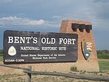 Bent's Old Fort entrance sign in Otero County, Colorado
 -
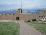 Bent's Old Fort outside view
 -
 "Gentlemen" who stopped by the fort while traveling the Santa Fe Trail stayed in the upstairs quarters.
 -
 Row of rooms on the right side of the fort
 -
 The billiards room was located on the second floor of the fort.
 -
 Clothes washing area at Bent's Old Fort
 -
 View of the entrance from inside Bent's Old Fort


See also
- Bibliography of Colorado
- Geography of Colorado
- History of Colorado
- Index of Colorado-related articles
- List of Colorado-related lists
- List of forts in Colorado
- List of ghost towns in Colorado
- List of National Historic Landmarks in Colorado
- List of protected areas in Colorado
- List of trading posts in Colorado
- Outline of Colorado
Notes
- ^ "Listing of acreage – December 31, 2011" (XLSX). Land Resource Division, National Park Service. Retrieved March 30, 2012. (National Park Service Acreage Reports)
- ^ "NPS Annual Recreation Visits Report". National Park Service. Retrieved March 30, 2012.
- ^ "National Register Information System". National Register of Historic Places. National Park Service. January 23, 2007.
- ^ a b "Bent's Old Fort". National Historic Landmark summary listing. National Park Service. September 28, 2007. Archived from the original on February 6, 2009.
- ^ "Bent's Old Fort or Fort William", April 20, 1984, by Carl McWilliams and Karen Johnson". National Register of Historic Places Inventory-Nomination. National Park Service. 1983.
- ^ "Bent's Old Fort or Fort William--Accompanying 20 photos, from 1983". National Register of Historic Places Inventory-Nomination. National Park Service. 1983.
- ^ Hampton Slides, Blood and Thunder, at p. 43 (2006) (Anchor Books paperback ed.)
- ^ Memoires of My Life--John charles Fremont, Cooper Square Press, 2001, p. 426-428
- ISBN 978-0-8032-8116-5.
- ^ Ralph Emerson Twitchell, 'The History of the Military Occupation of the Territory of New Mexico from 1846 to 1851 by the Government of the United States Archived September 30, 2016, at the Wayback Machine (1909) p.40
- ^ Pages 53 to 65, 94, 102, Halaas and Masich, Halfbreed
- ISBN 0 330 28004 X
- ^ Restaurant Website Archived November 23, 2012, at the Wayback Machine
References
- David Fridtjof Halaas and ISBN 978-0306814105
Further reading
- Blassingame, Wyatt (1967). Bent's Fort, Crossroads of the Great West. Champaign, Ill.: Garrard Pub. Co. p. 96 p. OCLC 887106.; for juvenile audience
- .
- Lavender, David (1954). Bent's Fort. Garden City, N.Y.: University of Nebraska Press. ISBN 0-8032-5753-8
- Legg, John (1993). War at Bent's Fort, historical novel. Siegel & Sigel Ltd. ISBN 0-312-95053-5.
External links
 Media from Commons
 News from Wikinews
 Quotations from Wikiquote
 Travel information from Wikivoyage
- State of Colorado
- Bent's Old Fort National Historic Site National Park Service
- Bent's Old Fort: Amphibians and Reptiles[permanent dead link]United States Geological Survey
- Photos of Bents Fort provided by Rocky mountain Profiles
- Architectural drawings and documentation[Historic American Buildings Survey
Municipalities and communities of Otero County, Colorado, United States | ||
|---|---|---|
| Cities | 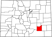 | |
| Towns | ||
| CDPs | ||
| Unincorporated communities | ||
| Ghost town | ||
| Trading posts |
| |
| ||
| Overview | |||||||||
|---|---|---|---|---|---|---|---|---|---|
| Contemporary peoples native to Colorado |
| ||||||||
| Prehistoric cultures in Colorado |
| ||||||||
| Related articles |
| ||||||||