
Didymoteicho
Didymoteicho
Διδυμότειχο | |
|---|---|
UTC+3 (EEST) | |
| Postal code | 683 00 |
| Area code(s) | 25530 |
| Vehicle registration | OP |
| Website | www.didymoteicho.gr |
Didymoteicho (Greek: Διδυμότειχο, romanized: Didymóteicho IPA: [ðiðiˈmotixo]) is a town located on the eastern edge of the Evros regional unit of Eastern Macedonia and Thrace, in northeastern Greece. It is the seat of the municipality of the same name. The town (pop. 8,681 in 2021) sits on a plain and located south east of Svilengrad, south of Edirne, Turkey and Orestiada, west of Uzunköprü, Turkey, about 20 km north of Soufli and about 90 km north of Alexandroupoli. The municipality of Didymóteicho has a land area of 565.4 km2 and a population of 16,060 inhabitants.
Etymology
"Didymoteicho" is the modern Greek form of Διδυμότειχον, Didymóteichon, from δίδυμος, dídymos, "twin" and τεῖχος, teîchos, "wall". The name first appears in 591/592, and most resulted from the refortification of the city under Justinian I (see below).[3]
The corrupted short form Dimotica or Demotica or variants thereof are attested in Western languages since the late 12th century (early forms Timoticon, Dimothicon, Dimodica),[4] and remained in use for the city until the 20th century.[5] The city was called ديمتوقه in Ottoman Turkish and is still called Dimetoka in Turkish, which was its name during the rule of the Ottoman Empire, and Dimotika (from Bulgarian Димотика) by the Pomaks of the region.
Geography
Forests dominate the banks and parts of the plain. Much of the area is used for farming. The main products are cattle, fruit and vegetables and some flowers. The hills dominate further west. Near the area lies the great
Municipality

The municipality Didymoteicho was formed at the 2011 local government reform by the merger of the following 2 former municipalities, that became municipal units:[6]
- Didymoteicho
- Metaxades
The municipality has an area of 565.372 km2, the municipal unit 354.134 km2.[7]
Communities
The municipal unit Didymoteicho is subdivided into the following communities (constituent settlements in brackets):[6]
- Didymoteicho (Didymoteicho, Zoodochos Pigi, Neoi Psathades)
- Asvestades
- Asimenio
- Ellinochori (Ellinochori, Thyrea, Lagos)
- Isaakio
- Karoti
- Koufovouno
- Kyani
- Lagos
- Mani (Mani, Evgeniko, Sitaria)
- Petrades
- Poimeniko
- Prangio
- Pythio (Pythio, Rigio, Stathmos)
- Rigio
- Sitochori
- Sofiko
The largest settlements, other than Didymoteicho itself, are Sofikó (pop. 795), Metaxades (687), Koufóvouno (629), Lagós (620) and Ellinochóri (593).
Province
The province of Didymoteicho (Greek: Επαρχία Διδυμοτείχου) was one of the provinces of the Evros Prefecture. Its territory corresponded with that of the current municipality Didymoteicho and the municipal unit Orfeas.[8] It was abolished in 2006.
History
Antiquity

The area around the town was inhabited in
The city had been built in a very strategic position, because it had for exploitation a very fertile plain and also controlled a passage of Erythropotamos, through which passed a branch of the via Egnatia leading in the middle and upper valley of Evros river and on the shores of the Black Sea.[9]
The city would later be one of the most important towns in Thrace, having its own assembly, and an episcopal see (suffragan of
The first bishop of the city, Hierophilus, is mentioned in the 430s.[3]
Medieval era

According to
In summer 813, during his
In winter 1100/01, Alexios I Komnenos allowed the Lombards of the Crusade of 1101 to resupply at the city.[4] During the 12th century, members of the Petraliphas family are known to have lived in the city.[4] On 24 November 1189, the city was captured and largely destroyed by the forces of the Third Crusade under Frederick VI, Duke of Swabia, who had captured Adrianople two days before.[4] In the 1198 chrysobull granted to the Republic of Venice, Didymoteicho and Adrianople are mentioned as forming a single province.[4] In 1205, French writer Geoffroi de Villehardouin wrote of the important of the city, referring to Didymoteicho “was the most powerful and one of the richest Romanic cities”.
Following the


In February 1205, however, the locals rose up in revolt in Didymoteicho, Adrianople and other cities, evicted their Latin garrisons, and acknowledged the suzerainty of the Bulgarian Tsar Kalojan. Baldwin of Flanders responded by marching into Thrace and besieging Adrianople, but at the subsequent Battle of Adrianople (14 April 1205) the Latin army suffered a crushing defeat and Baldwin was taken prisoner.[13][14] The city, effectively autonomous, served as a place of refuge for the local population fleeing the depredations of Kalojan following his victory.[4] A Latin siege of the city was broken up in September 1205 due to a flood of the Evros (or the Erythropotamos),[4] but after Kalojan's massacres of the inhabitants of the cities of Serres and Philippopolis, the Thracian cities turned to the new regent of the Latin Empire, Henry of Flanders (r. 1205–1216). Thus in early 1206 Didymoteicho and Adrianople submitted to the Greek lord Theodore Branas, who was in the Latin Emperor's service. Kalojan besieged Didymoteicho in early summer, and was on the point of taking the city when a relief army under Henry arrived. Before Branas had time to repair the fortifications, however, in early autumn, Kalojan returned and sacked the city. Henry of Flanders managed to rescue the inhabitants as they were being taken prisoner to Bulgaria, but before he withdrew from the city, Kalojan ordered the town's fortifications razed, making it useless as a military base.[4][15][16]
In 1225, the city was captured by the ambitious Greek ruler of
Finally the Empire of Nicaea returned Didymoteicho to Byzantine control by capturing it around 1243, during the reign of John III Doukas Vatatzes.[10] In 1255/56, Theodore II Laskaris used the city as a base of operations for his campaigns against Bulgaria.[4] The city was once again the centre of military operations in 1306, when Michael IX Palaiologos campaigned against the Catalan Company,[4] and again during the Byzantine civil war of 1321–1328 between Andronikos II Palaiologos (r. 1282–1328) and his grandson, Andronikos III (r. 1328–1341). The latter made Didymoteicho his main base and residence during the conflict, and the city remained a stronghold and was frequently visited by Andronikos III during his reign.[4] The city also served as a secure place of exile and incarceration of the emperor's opponents, from his uncle Constantine Palaiologos in 1322 to the disgraced chief minister Theodore Metochites in 1328.[4]
During the
The city was the birthplace of emperors John III Doukas Vatatzes (born c. 1193) and John V Palaiologos (born 18 June 1332).[20]
Ottoman era

The city—known as Dimetoka or Demotika under Ottoman rule—was captured by the Ottomans in 1359 and again, this time permanently (probably by the commander
It nevertheless remained a "favourite resort of early Ottoman rulers" due to its rich hunting grounds even after the capital moved to Adrianople and
The Ottoman traveller
Swedish king
Modern era

In 1912 the village was briefly occupied by the Bulgarians during the
Modern Didymoteicho is home to numerous descendants of
The village was considerably affected by the Evros river flooding of 17 to 22 February 2005. Flood warnings were reported at that time. The flood affected much of the town on Wednesday, 2 March 2005 and continued for several days. On Friday, 4 March, flood waters began to ebb slowly. Over 5,000 mm of rainfall caused the river to overflow its banks. Buildings, properties and stores were flooded, leaving people stranded. It was the worst flood in nearly 50 years. The railway line south of Didymoteicho and near the station was also flooded and was closed. Serious flooding was also experienced in March 2006 and November 2014, while in the Evros floods of 2021 the largest floods took place throughout the city and the general Evros and Erythropotamos river areas.
Didymoteicho is just 2 kilometers away from the Greek-Turkish border, and as a result it is home to many Greek military units and Hellenic Army training centers. Hundreds of thousands of Greek men had to either receive military training or spend part of their military service here (see conscription in Greece). The famous 1991 George Dalaras and Lavrentis Machairitsas song Didymoteicho Blues (Greek: Διδυμότειχο Μπλουζ) pays homage to the personal stories and experiences of these soldiers while offering a more general commentary about life in the Army.[23]
Landmarks
- The Didymoteicho Fortress, the medieval citadel or "old town", situated in the northwestern part of town
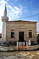
- The Çelebi Sultan Mehmed Mosque or Beyazid Mosque, completed in 1420.
- Didymoteicho Folklore Museum
- The Silent Baths or Oruç Pasha Hamam, the oldest hamam in Europe. Today there are only ruins of the baths[24] but a European Union project has been initiated to restore them.[25]
- International Centre of Young Artists of Eastern Europe, Website
- Central Square, next to the town hall
- Feridun Ahmed Bey Hamam
- Golden Bust of Septimius Severus discovered in Didymoteicho, now in Archaeological Museum of Komotini
- Didymoteicho Military Museum
- Municipal Theatre, on Georgios I Street
- The ruins of the ancient city of Plotinopolis.
- Oruç Pasha türbe
Transport
Rail
The town is served by a station on the Alexandroupoli–Svilengrad Line.
Historical population
| Year | Municipal unit | Municipality |
|---|---|---|
| 1991 | 19,450 | – |
| 2001 | 18,998 | – |
| 2011 | 16,078 | 19,493 |
| 2021 | 13,673 | 16,060 |
Notable people
- John III Doukas Vatatzes (c. 1192–1254), emperor of Nicaea
- John V Palaiologos (1332–1391), Byzantine Emperor
- Bayezid II (1481–1512) Sultan of the Ottoman Empire
- Eugenios Eugenidis (1882–1954), shipping magnate
- Grand Vizierof the Ottoman Empire
- Konstantinos Gatsioudis, javelin thrower
- Zoi Dimoschaki, swimmer from Isaakio, a village near Didymoteicho
Gallery
-
 Vasilopoula Byzantine tower
 -
 The entrance of the church with a statue of Constantine XI Palaiologos
 -
 The church with the remains of an arch
 -
 Church interior
 -
 Church dome interior
 -
 Alaca mosque


See also
References
- ^ "Πως σώθηκαν τα μνημεία του Καλέ από την πυρκαγιά". 12 August 2020.
- ^ "Αποτελέσματα Απογραφής Πληθυσμού - Κατοικιών 2021, Μόνιμος Πληθυσμός κατά οικισμό" [Results of the 2021 Population - Housing Census, Permanent population by settlement] (in Greek). Hellenic Statistical Authority. 29 March 2024.
- ^ a b c d e f g h Soustal 1991, p. 420.
- ^ a b c d e f g h i j k l m n o p Soustal 1991, p. 421.
- ^ Chisholm, Hugh, ed. (1911). . Encyclopædia Britannica. Vol. 8 (11th ed.). Cambridge University Press.
- ^ a b "ΦΕΚ B 1292/2010, Kallikratis reform municipalities" (in Greek). Government Gazette.
- ^ "Population & housing census 2001 (incl. area and average elevation)" (PDF) (in Greek). National Statistical Service of Greece. Archived from the original (PDF) on 21 September 2015.
- ^ "Detailed census results 1991" (PDF). Archived from the original (PDF) on 3 March 2016. (39 MB) (in Greek and French)
- ^ D. C. Samsaris, Historical Geography of Western Thrace during the Roman Antiquity (in Greek), Thessaloniki 2005, p. 114-120
- ^ ISBN 0-19-504652-8.
- ^ Soustal 1991, pp. 420–421.
- ^ Wolff 1969, p. 192.
- ^ Fine 1994, pp. 83–84.
- ^ Wolff 1969, p. 203.
- ^ Fine 1994, pp. 84–86.
- ^ Wolff 1969, pp. 203–204.
- ^ Soustal 1991, pp. 421–422.
- ^ ISBN 90-04-07026-5.
- ^ a b c Soustal 1991, p. 422.
- ^ "Θρακική Εστία Ν. Σερρών". Archived from the original on 24 September 2008. Retrieved 8 October 2008.
- ^ "World War I Document Archive". www.lib.byu.edu. Retrieved 12 April 2018.
- ^ "Didimoticho".
- ^ Καραντής, Τάσος Π. "Λαυρέντης Μαχαιρίτσας: Διδυμότειχο Blues - e-orfeas.gr. Με άποψη στη μουσική και στο τραγούδι". www.e-orfeas.gr. Retrieved 12 April 2018.
- ^ Eleni Kanetaki (2005). "The still existing ottoman hamams in the Greek territory" (PDF). Middle East Technical University / Faculty of Architecture. Archived from the original (PDF) on 24 January 2013. Retrieved 2012-06-06.
- ^ "JOVAPROB / Joint valorisation and promotion of the old baths in the trans border area". European Territorial Cooperation – Greece Bulgaria 2007–2013. Retrieved 6 June 2012.
Sources
- ISBN 0-472-08260-4.
- Soustal, Peter (1991). Tabula Imperii Byzantini, Band 6: Thrakien (Thrakē, Rodopē und Haimimontos) (in German). Vienna: ISBN 978-3-7001-1898-5.
- Wolff, Robert Lee (1969) [1962]. "The Latin Empire of Constantinople, 1204–1261". In ISBN 0-299-04844-6.
External links
- Official website (in Greek)
- Official website (in English)
- Official website (in Turkish)
- Official website (in Bulgarian)
- Hellenic Ministry of Culture: Didymoticho
Places adjacent to Didymoteicho | |
|---|---|
Administrative division of the Eastern Macedonia and Thrace Region | ||
|---|---|---|
| Regional unit of Drama |  | |
| Regional unit of Evros | ||
| Regional unit of Kavala | ||
| Regional unit of Rhodope | ||
| Regional unit of Thasos | ||
| Regional unit of Xanthi | ||
| ||
| International | |
|---|---|
| National | |
| Other | |