
Exploration of North America
The exploration of North America by European sailors and geographers was an effort by major European powers to map and explore the continent with the goal of economic, religious and military expansion. The combative and rapid nature of this exploration is the result of a series of countering actions by neighboring European nations to ensure no single country had garnered enough wealth and power from the Americas to militarily tip the scales over on the European continent. It spanned the late 15th to early 17th centuries, and consisted primarily of expeditions funded by Spain, England, France, and Portugal. See also the European colonization of the Americas.
Pre-Columbian exploration
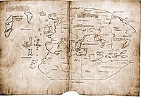
According to the Sagas of Icelanders, Norse sailors (often called Vikings) from Iceland first settled Greenland in the 980s. Erik the Red explored and settled southwestern Greenland, which he named to entice potential Icelandic settlers, eventually establishing the Eastern and Western Settlements, which were abandoned around 1350.
L'Anse aux Meadows, an archaeological site on the northernmost tip of Newfoundland, and a second site in southwestern Newfoundland, are the only known sites of a Norse village in North America outside of Greenland. These sites are notable for their possible connections with the attempted colony of Vinland established by Leif Erikson in 1003.
Age of Discovery and the search for the Northwest Passage
| Part of a series on |
| European colonization of the Americas |
|---|
.svg) |
|
|
The Viking voyages did not become common knowledge in the Old World, and Europeans remained unaware of the existence of the Americas as a whole, until 1492. Many expeditions were launched from European nations in search of a Northwest Passage to East Asia (or "the Indies" as the region was called) in order to establish a shorter trade route to China than the Silk Road, a trade route which had become desperately needed and yet exacerbated by the fall of Constantinople. Also, the Castilian crown needed an alternative to the Portuguese controlled eastern maritime trade route around Africa to India and East Asia.
On August 3, 1492, the Italian navigator
Italian navigator and explorer
In 1499
It was soon understood that Columbus had not reached Asia, but rather found what was to Europeans a New World, which in 1507 was named "America", after Amerigo Vespucci, on the Waldseemüller map.
Further nautical explorations
In 1500, Pedro Álvares Cabral was sent by Portugal to explore South America. He is considered to be the discoverer of Brazil.
King
On September 25, 1513, Spanish
Around 1519–1521, with a mission to establish colonies for Portugal, João Álvares Fagundes explored the coasts of Newfoundland, Labrador, and Nova Scotia.
In 1521, Juan Ponce de León attempted to establish a permanent settlement on the west coast of Florida. The landing place has not been determined. His expedition was repulsed by natives. Ponce de León was struck by an arrow, and died of his wounds.
In 1524, Italian explorer Giovanni da Verrazzano sailed for King Francis I of France, and is known as the first European since the Norse to explore the Atlantic coast of North America. Arriving near the Cape Fear River delta, he explored the coastlines of present-day states of North and South Carolina, entering the Pamlico Sound, and bypassing entrances to the Chesapeake Bay. Believing the New York Harbor to be a lake, he sailed past Long Island, exploring Narragansett Bay and Newfoundland.
In 1524–1525, Portuguese explorer
In 1528, Pánfilo de Narváez, who had been named adelantado (governor) of La Florida by Carlos I, the King of Spain, landed in Boca Ciega Bay on the west coast of Florida to begin the ill-fated land expedition of 300 men, of which only four survived. One survivor, Álvar Núñez Cabeza de Vaca, wrote the Relación, his book of the eight-year survival journey, on his return to Spain.[5]
In 1534,
In 1539

After two failed attempts to reach East Asia by circumnavigating Siberia, Henry Hudson sailed west in 1609 under the Dutch East India Company. He, too, passed Cape Cod, Chesapeake Bay and the Delaware Bay, instead sailing up the Hudson River on September 11, 1609 in search of a fabled connection to the Pacific via what was actually the Great Lakes. In Hudson's fourth and final voyage, he discovered, mapped, and explored the Hudson Strait, Hudson Bay and James Bay.
Other major sea-based explorers were Captain James Cook, George Vancouver, and Charles Wilkes.
Overland exploration of the West
16th to 17th centuries
There were numerous Spanish explorers and

In 1608 Samuel de Champlain founded what is now Quebec City, which would become the first permanent settlement and the capital of New France. He took personal administration over the city and its affairs, and sent out expeditions to explore the interior. Champlain himself discovered Lake Champlain in 1609. By 1615, he had travelled by canoe up the Ottawa River through Lake Nipissing and Georgian Bay to the centre of Huron country near Lake Simcoe. During these voyages, Champlain aided the Wendat (aka 'Hurons') in their battles against the Iroquois Confederacy. As a result, the Iroquois would become enemies of the French and be involved in multiple conflicts.
From 1679 to 1682 René-Robert Cavelier, Sieur de La Salle explored the Great Lakes region of the United States and Canada, and the entire course of Mississippi River to the Gulf of Mexico.
From 1697 to 1702 Eusebio Kino explored the Sonoran Desert and on his journey to the Colorado River Delta discovered an overland route to Baja California that was then commonly believed to be an island. In 1683 Kino led the first European overland crossing of Baja California.
European exploration of western Canada was largely motivated by the fur trade and the search for the elusive Northwest Passage. Hudson's Bay Company explorer Henry Kelsey has the distinction of being the first European to see the northern Great Plains in 1690.
18th century
Anthony Henday was the first to have seen the Rocky Mountains, in 1754, but curiously did not mention it in his journals. From his westernmost geographic position (roughly near the town of Olds, Alberta, halfway between Calgary and Red Deer, Alberta) the Rockies should have been quite conspicuous, but he was likely trying to disguise the disappointing fact that an unknown range of seemingly impassible mountains now stood between the Hudson's Bay Company and the Pacific. Samuel Hearne found the Coppermine River in 1769–71 in his failed search for copper ore deposits. Disillusioned by these shortfalls, the HBC largely quit exploration.
The North West Company, on the other hand, used a business model that required constant expansion into untapped areas. Under the auspices of the NWC, Alexander Mackenzie discovered the Mackenzie River in 1789 and was the first European to reach the North-American Pacific overland, via the Bella Coola River, in 1793. Simon Fraser reached the Pacific in 1808 via the Fraser River.
19th century to present
John C. Frémont led many important explorations in the Great Plains, Great Basin, Oregon territory, and Mexican Alta California.
As the American population of the West increased, the US government launched ongoing official explorations mainly through the
Gallery
- Maps of the New World
-
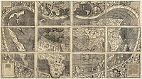 Universalis Cosmographia, the Waldseemüller map dated 1507, depicts the Americas, Africa, Europe, Asia, and the Pacific Ocean separating Asia from the Americas.
 -


See also
Historical overviews
- 16th century in North American history
- Age of Discovery
- Notable cartographers of the Age of Exploration
- National Historic Trail
- Americas (terminology)
- European colonization of the Americas
- Voyages of Christopher Columbus
Specific eras, explorers, regions, and efforts
- Mountain men
- Amerigo Vespucci, Martin Waldseemüller + Matthias Ringmann: originators of term America
References
- ISBN 0-8032-5049-5.
- ISBN 0-8032-5049-5.
- ^ Cassanello, Robert (24 January 2014). ""Episode 06 Early Maps of Florida" by Robert Cassanello and Kendra Hazen". A History of Central Florida Podcast. Retrieved 2016-01-10.
- ^ Cassanello, Robert (24 January 2014). ""Episode 06 Early Maps of Florida" by Robert Cassanello and Kendra Hazen". A History of Central Florida Podcast. Retrieved 2016-01-10.
- ISBN 978-0-8032-1463-7., 3 vols.
- ^ Aritha Van Herk, Travels with Charlotte, Canadian Geographic Magazine, July/August 2007
- ^ "Lac La Biche 2004-5". Atlas of Alberta Lakes. Edmonton, Alberta: University of Alberta. Archived from the original on 2013-11-02.
Bibliography
- Ambrose, Stephen E.Undaunted Courage: Meriwether Lewis, Thomas Jefferson, and the Opening of the American West, New York: Simon & Schuster (1996).
- Bartlett, Richard. Great Surveys of the American West. Norman: University of Oklahoma Press, 1980.
- Fernlund, Kevin J.William Henry Holmes and the Rediscovery of the American West. Albuquerque: University of New Mexico Press, 2000.
- Goetzmann, William H. Exploration and Empire: The Explorer and the Scientist in the Winning of the American West. New York: Alfred A. Knopf, 1966.
- Maura, Juan Francisco. Españoles y portugueses en Canadá en tiempos de Cristóbal Colón. Colección Parnase-Lemir, Valencia: Universidad de Valencia, 2021. http://parnaseo.uv.es/Lemir/Textos/Juan_Maura_Lemir.pdf
- Pyne, Stephen J. Grove Karl Gilbert: A Great Engine of Research. Austin: University of Texas Press, 1980.
- Stegner, Wallace. Beyond the Hundredth Meridian: John Wesley Powell and the Second Opening of the West. Houghton, Mifflin, 1954.
- Andrews, J.Rr. "Spain's Conquest of America." The Hispanic American Historical Review, vol. 33, no. 4, University of California Press, 1953, pp. 623–637
- Gibson, Charles. "The Aztecs Under Spanish Rule: A History of the Indians of the Valley of Mexico." Stanford University Press, 1964.
- Himmerich y Valencia, Robert. "The Encomenderos of New Spain, 1521–1555." University of Texas Press, 1991.
- Seed, Patricia. "Colonial Spanish America: A Documentary History." Rowman & Littlefield, 1998.
- Restall, Matthew. "Seven Myths of the Spanish Conquest." Oxford University Press, 2003.
- Johnson, Lyman, and Sonya Lipsett-Rivera. "The Faces of Honor: Sex, Shame, and Violence in Colonial Latin America." University of New Mexico Press, 2003.
- Vitoria, Francisco de. "De Indis et de Iure Belli Relectiones." Reprint edition, Lawbook Exchange Ltd, 2006.
- Lockhart, James and Stuart Schwartz. "Early Latin America: A History of Colonial Spanish America and Brazil." Cambridge University Press, 1983.
- Varon Gabai, Rafael. "Other Council Fires Were Here Before Ours: A Classic Native American Creation Story as Retold by a Contemporary Seneca/Oneida Writer." Syracuse University Press, 2013.
- Mignolo, Walter D. "The Darker Side of the Renaissance: Literacy, Territoriality, and Colonization." University of Michigan Press, 1996.
Further reading
- Enrigue, Álvaro, "The Discovery of Europe" (review of Caroline Dodds Pennock, On Savage Shores: How Indigenous Americans Discovered Europe, Knopf, 2023, 302 pp.), The New York Review of Books, vol. LXXI, no. 1 (18 January 2024), pp. 34–35, 39. Caroline Dodds Pennock writes: "We need to invert our understanding of encounter to see transatlantic migration and connection not just as stretching to the west, but also as originating there." (p. 34.) According to the reviewer, "Until now the experiences of indigenous Americans in Europe had not been put together in one place.... On Savage Shores... sets the methodological standard for a new way of understanding the origin of the modern world." (p. 39.)
External links
- National Park Service links and materials on explorers of North America
- Historical Maps and Prints - A diverse collection (1503-1910) from the UBC Library Digital Collections that pertains to the exploration and mapping of the world, the evolution of cartography, and the settlement of North America
- Early Maps of Florida at A History of Central Florida Podcast