
Gangtok
This article's tone or style may not reflect the encyclopedic tone used on Wikipedia. (January 2025) |
Gangtok | |
|---|---|
UTC+5:30 (IST) | |
| PIN | 737101 |
| Telephone code | 03592 |
| Vehicle registration | SK-01 |
| Website | gangtokdistrict |
Gangtok (
Gangtok rose to prominence as a popular
Etymology
The precise meaning of the name "Gangtok" is unclear, though most agree that the meaning is "hill top".In
History
Like the rest of Sikkim, not much is known about the early history of Gangtok.
In 1894,
In 1975, after years of political uncertainty and struggle, including riots, the monarchy was abrogated and Sikkim became India's twenty-second state, with Gangtok as its capital after a referendum. Gangtok has witnessed annual landslides, resulting in loss of life and damage to property. The largest disaster occurred in June 1997, when 38 were killed and hundreds of buildings were destroyed.[13]
Geography
Gangtok is located at 27°19′57″N 88°36′50″E / 27.3325°N 88.6140°E (coordinates of Gangtok head post office).[2] It is in the lower Himalayas at an elevation of 1,650 m (5,410 ft).[14] The town is on the side of a hill, with "The Ridge",[8][15] a promenade with the Raj Bhawan, the governor's residence, at one end and the palace, at an altitude of about 1,800 m (5,900 ft), at the other. The city is flanked east and west by two streams, Roro Chu and Ranikhola.[13] These two rivers divide the natural drainage into two parts, eastern and western. Both streams meet the Ranipul and flow south as the Ranikhola before joining the Teesta at Singtam.[13] Most roads are steep, with the buildings built on compacted ground alongside them.[16]

Most of
Densely forested regions surround Gangtok, temperate,
Climate
| Climate data for Gangtok (1991–2020, extremes 1966–present) | |||||||||||||
|---|---|---|---|---|---|---|---|---|---|---|---|---|---|
| Month | Jan | Feb | Mar | Apr | May | Jun | Jul | Aug | Sep | Oct | Nov | Dec | Year |
| Record high °C (°F) | 19.9 (67.8) |
22.0 (71.6) |
27.6 (81.7) |
27.3 (81.1) |
28.5 (83.3) |
28.4 (83.1) |
28.4 (83.1) |
29.9 (85.8) |
28.5 (83.3) |
27.2 (81.0) |
25.5 (77.9) |
24.0 (75.2) |
29.9 (85.8) |
| Mean daily maximum °C (°F) | 12.4 (54.3) |
14.3 (57.7) |
17.7 (63.9) |
20.4 (68.7) |
21.4 (70.5) |
22.0 (71.6) |
21.6 (70.9) |
22.1 (71.8) |
21.5 (70.7) |
20.4 (68.7) |
17.2 (63.0) |
14.1 (57.4) |
18.8 (65.8) |
| Mean daily minimum °C (°F) | 5.5 (41.9) |
7.3 (45.1) |
10.1 (50.2) |
12.7 (54.9) |
14.9 (58.8) |
17.1 (62.8) |
17.7 (63.9) |
17.7 (63.9) |
16.7 (62.1) |
13.8 (56.8) |
10.2 (50.4) |
7.2 (45.0) |
12.6 (54.7) |
| Record low °C (°F) | −2.2 (28.0) |
−1.1 (30.0) |
1.4 (34.5) |
2.9 (37.2) |
6.6 (43.9) |
10.0 (50.0) |
11.3 (52.3) |
10.8 (51.4) |
7.7 (45.9) |
4.3 (39.7) |
2.4 (36.3) |
−1.7 (28.9) |
−2.2 (28.0) |
| Average rainfall mm (inches) | 26.2 (1.03) |
53.6 (2.11) |
133.2 (5.24) |
333.3 (13.12) |
496.1 (19.53) |
647.0 (25.47) |
655.2 (25.80) |
547.5 (21.56) |
427.7 (16.84) |
174.3 (6.86) |
36.9 (1.45) |
16.0 (0.63) |
3,574 (140.71) |
| Average rainy days | 2.5 | 4.7 | 9.9 | 16.3 | 20.8 | 23.6 | 27.6 | 25.5 | 21.4 | 8.4 | 2.2 | 1.4 | 164.3 |
| Average relative humidity (%) (at 17:30 IST )
|
75 | 77 | 75 | 79 | 85 | 89 | 92 | 92 | 90 | 83 | 79 | 76 | 82 |
| Source: India Meteorological Department[18][19][20][21] | |||||||||||||
Gangtok has a monsoon-influenced
-
 Monsoon clouds in Gangtok
 -
 Banjhakri Falls and Energy Park, Gangtok
 -
 River Teestais the lifeline of Gangtok
 -
 An overhead view of Gangtok from the ropeway facility


Economy


Gangtok is the main base for Sikkim tourism.[24] Summer and spring seasons are the most popular tourist seasons. Many of Gangtok's residents are employed directly and indirectly in the tourism industry, with many residents owning and working in hotels and restaurants.[25]
Mahatma Gandhi Marg and Lal Market are prominent business areas and tourist spots in Gangtok.[26]
Ecotourism has emerged as an important economic activity in the region which includes trekking, mountaineering, river rafting and other nature oriented activities.[24] An estimated 351,000 tourists visited Sikkim in 2007, generating revenue of about ₹500 million (equivalent to ₹1.5 billion or US$18 million in 2023).[25]
The
Gangtok's economy does not have a large manufacturing base, but has a thriving
Agriculture is a large employer in Sikkim and in 2003 the Sikkim state government declared the goal of converting the whole sector to organic production.[31] The goal of 100% organic was achieved in 2016.[31] This achievement offers new export opportunities to grow the agriculture sector, to achieve premium prices and new opportunities for agritourism.[31]
Civic administration
-
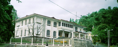 The "White Hall" complex on "The Ridge" houses the residences of theChief Ministerand Governor of Sikkim.
 -
 Sikkim Legislative Assembly in Gangtok. Fog is common in Gangtok.


Gangtok is administered by the Gangtok Municipal Corporation (GMC) along with the various departments of the Government of Sikkim, particularly the Urban Development and Housing Department (UDHD) and the Public Health Engineering Department (PHED).[13][32] These departments provide municipal functions such as garbage disposal, water supply, tax collection, licence allotments, and civic infrastructure. An administrator appointed by the state government heads the UDHD.[33]
As the headquarters of
Gangtok is within the
Utility services
Electricity is supplied by the power department of the
Around 40% of the population has access to sewers.
Transport
-
 Gangtok cable car
 -
 The Teesta River runs along the National Highway 31A connecting Gangtok to Siliguri.
 -
 National Highway 31A by the night.


Road
Gangtok is connected to the rest of India by an all-weather metalled highway,
Rail
The nearest railhead connected to the rest of India is New Jalpaiguri Junction railway station (station code - NJP) in Siliguri, 124 km (77 mi) from Gangtok via NH10. Another railway station near Gangtok is Siliguri Junction (station code - SGUJ). There are quite many trains that connect Siliguri Junction with Sealdah railway station in Kolkata and others parts of north-east India. Work has begun on a broad-gauge railway link from Sevoke in West Bengal to Rangpo in Sikkim,[44] which is planned for extension to Gangtok.[45]
Air

Pakyong Airport[46] is spread over 400 ha (990 acres) at Pakyong, about 35 km (22 mi) south of Gangtok.[47] At 1,400 m (4,500 ft), it is one of the five highest airports in India,[48] and also the first greenfield airport to be constructed in the Northeastern Region of India,[49] the 100th operational airport in India, and the only airport in the state of Sikkim.[50][51]
The airport was inaugurated by India's Prime Minister
Demographics
| Year | Pop. | ±% |
|---|---|---|
| 1951 | 2,744 | — |
| 1961 | 6,848 | +149.6% |
| 1971 | 13,308 | +94.3% |
| 1981 | 36,747 | +176.1% |
| 1991 | 25,024 | −31.9% |
| 2001 | 29,354 | +17.3% |
| 2011 | 98,658 | +236.1% |
| Population 1951–2011.[24] Negative growth attributed to reduction of notified town limits. | ||
According to the Provisional Population Totals 2011 census of India, the population of Gangtok Municipal Corporation has been estimated to be 98,658. Males constituted 53% of the population and females 47%. The Gangtok subdivision of the East Sikkim district had a population of 281,293, Gangtok has an average literacy rate of 82.17%, higher than the national average of 74%: male literacy is 85.33%, and female literacy is 78.68.[54] About 8% of Gangtok's population live in the nine notified slums and squatter settlements, all on Government land. More people live in areas that depict slum-like characteristics but have not been notified as slums yet because they have developed on private land.[55] Of the total urban population of Sikkim, Gangtok Municipal Corporation has a share of 55.5%. Including Gangtok, East District has a share of 88% of the total urban population. The quality of life, the pace of development and availability of basic infrastructure and employment prospects has been the major cause for rapid migration to the city. With this migration, the urban services are under pressure, intensified by the lack of availability of suitable land for infrastructure development.[13]
Ethnic
- Nepali 59.01 (59.0%)
- Hindi14.13 (14.1%)
- Bhutia10.11 (10.1%)
- Bhojpuri 2.74 (2.74%)
- Bengali 2.71 (2.71%)
- Lepcha 2.68 (2.68%)
- Tibetan 1.04 (1.04%)
- Tamang 1.01 (1.01%)
- Sherpa 0.9 (0.90%)
- Limbu 0.84 (0.84%)
- Marwari 0.72 (0.72%)
- Urdu0.6 (0.60%)
- Marathi 0.42 (0.42%)
- Odia 0.34 (0.34%)
- Malayalam0.33 (0.33%)
- Rai 0.28 (0.28%)
- Telugu 0.23 (0.23%)
- Assamese 0.19 (0.19%)
- Tamil 0.18 (0.18%)
- Manipuri 0.18 (0.18%)
- Maithili 0.11 (0.11%)
- Others 1.29 (1.29%)
Culture
-
 TheBuddhiststatues.
 -
 View of downtown Gangtok city from Crown Prince Tenzing Kunzang Namgyal Walkway.
 -
 Rumtek Monastery, located on the outskirts of Gangtok, is one of Buddhism's holiest monasteries.


Apart from the major religious festivals of
A popular food in Gangtok is the
City institutions
-
 Temple of the Maharajas, Gangtok. 1938.
 -
 The Himalayan black bear is seen here in the Himalayan Zoological Park.


A centre of Buddhist learning and culture, Gangtok's most notable Buddhist institutions are the
The
The
Education
Gangtok's schools are either run by the state government or by private and religious organisations. Schools mainly use English and
Colleges conferring graduate degrees include
Media
More than 50 newspapers are published in Sikkim.[80] Multiple local Nepali and English newspapers are published,[81] whereas regional and national Hindi and English newspapers, printed elsewhere in India, are also circulated.
Gangtok has two cinemas featuring Nepali,
The main service providers are Sikkim Cable, Nayuma,
See also
References
- ^ Ravidas, Rajeev (5 May 2021). "Nell Bahadur Chettri sworn in as the new mayor of Gangtok". The Telegraph. Retrieved 7 June 2022.
- ^ a b "Gangtok, India page". Global Gazetteer Version 2.1. Falling Rain Genomics, Inc. Archived from the original on 17 July 2011. Retrieved 19 June 2011.
- ^ "1977 Sikkim government gazette" (PDF). sikkim.gov.in. Governor of Sikkim. p. 188. Archived from the original (PDF) on 22 July 2018. Retrieved 28 May 2019.
- ^ "50th Report of the Commissioner for Linguistic Minorities in India" (PDF). 16 July 2014. p. 109. Archived from the original (PDF) on 2 January 2018. Retrieved 28 May 2019.
- ^ a b
Bannerjee, Parag (14 October 2007). "Next weekend you can be at ... Gangtok". The Telegraph. Archived from the originalon 21 February 2009. Retrieved 21 May 2008.
- ^
Shangderpa, Pema Leyda (6 October 2003). "Kids to learn hill state history". The Telegraph. Archived from the originalon 23 October 2012. Retrieved 2 May 2008.
- ^
Bernier, Ronald M. (1997). Himalayan Architecture. Fairleigh Dickinson Univ Press. pp. 40–42. ISBN 0-8386-3602-0.
- ^ a b Lepcha, N.S. "Gangtok Capital Attraction". Himalayan Travel Trade Journal. MD Publishing Co. Pvt. Ltd. Archived from the original on 16 August 2007. Retrieved 3 May 2008.
- ^ "History of Sikkim". sikkim.nic.in. National Informatics Centre, Sikkim. Archived from the original on 30 April 2001. Retrieved 20 May 2008.
- ^ a b Jha, Prashant (August 2006). "Special report: A break in the ridgeline". Himal South Asia. South Asia Trust. Archived from the original on 30 October 2006. Retrieved 20 May 2008.
- ISBN 978-0-8203-4512-3
- ^ "Historic India-China link opens". BBC News. 6 July 2006. Archived from the original on 7 July 2006. Retrieved 6 July 2006.
- ^ a b c d e f g h i j k l m n o p q r s t u v w x y "Section 4: City Assessment" (PDF). City Development Plan-Gangtok City. Jawaharlal Nehru National Urban Renewal Mission, Ministry of Urban Development, Government of India. Archived from the original (PDF) on 5 February 2011. Retrieved 28 June 2011.
- ^ "Geographical Location". Meteorological Centre, Gangtok. India Meteorological Department, Ministry of Earth Sciences, Government of India. Archived from the original on 12 May 2008. Retrieved 3 May 2008.
- ^
Negi, S. S. (1998). Discovering the Himalaya. Indus Publishing. p. 563. ISBN 81-7387-079-9.
- ^ "Gangtok City". mapsofindia.com. Compare Infobase Limited. Archived from the original on 16 March 2008. Retrieved 3 May 2008.
- ^ a b c d e f g h "Section 2: Introduction To The State And Its Capital" (PDF). City Development Plan-Gangtok City. Jawaharlal Nehru National Urban Renewal Mission, Ministry of Urban Development, Government of India. Archived from the original (PDF) on 28 May 2008. Retrieved 7 May 2008.
- ^ "Climatological Tables of Observatories in India 1991-2020" (PDF). India Meteorological Department. Retrieved 8 April 2024.
- ^ "Station: Gangtok Climatological Table 1981–2010" (PDF). Climatological Normals 1981–2010. India Meteorological Department. January 2015. pp. 279–280. Archived from the original (PDF) on 5 February 2020. Retrieved 7 October 2020.
- ^ "Extremes of Temperature & Rainfall for Indian Stations (Up to 2012)" (PDF). India Meteorological Department. December 2016. p. M190. Archived from the original (PDF) on 5 February 2020. Retrieved 5 February 2020.
- ^ "Gangtok Climatological Table 1971–2000". India Meteorological Department. Retrieved 5 February 2020.
- ^ a b c "Meteorological data in respect of Gangtok and Tadong station". Meteorological Centre, Gangtok. India Meteorological Department, Ministry of Earth Sciences, Government of India. Archived from the original on 14 June 2008. Retrieved 7 May 2008.
- ^ "Gangtok sees snowfall after 15 years". Northeast Today. 7 January 2020. Retrieved 9 January 2020.
- ^ a b c d e f g h i j "Section 3: Social, Demographic & Economic Profile" (PDF). City Development Plan-Gangtok City. Jawaharlal Nehru National Urban Renewal Mission, Ministry of Urban Development, Government of India. Archived from the original (PDF) on 9 April 2011. Retrieved 28 June 2011.
- ^ a b Press Trust of India (24 April 2008). "Tourist inflow in Sikkim up 10% in 2007". Business Standard. Archived from the original on 11 May 2008. Retrieved 7 May 2008.
- ^ Sen, Piyali (27 January 2020). "Secret Gangtok: 5 Things That No One Will Tell You About". Outlook. Retrieved 1 September 2020.
- ^ Sinha, A. C. (September 2005). "Nathula: Trading in uncertainty". Himal South Asia. South Asia Trust. Archived from the original on 10 May 2008. Retrieved 7 May 2008.
- ^ Atreya, Satikah (4 March 2008). "Decision to exempt incomes of Sikkim subjects hailed". The Hindu Business Line. Archived from the original on 1 July 2011. Retrieved 28 June 2011.
- ^ Mohan, C. Raja (29 June 2003). "Building a gateway to Tibet". The Hindu. Archived from the original on 4 May 2008. Retrieved 21 May 2008.
- ^ Shangderpa, Pema Leyda (12 July 2003). "Ducking court blow, Gangtok retailers play to win". The Telegraph. Archived from the original on 10 May 2008. Retrieved 12 July 2003.
- ^ a b c Paull, John (2017) "Four New Strategies to Grow the Organic Agriculture Sector" Archived 4 March 2018 at the Wayback Machine, Agrofor International Journal, 2(3):61-70.
- ^ "Introduction". Urban Development and Housing Department. Government of Sikkim. Archived from the original on 14 September 2013. Retrieved 7 May 2008.
- ^ "Section 8: City Management and Institutional Strengthening" (PDF). City Development Plan-Gangtok City. Jawaharlal Nehru National Urban Renewal Mission, Ministry of Urban Development, Government of India. Archived from the original (PDF) on 26 March 2012. Retrieved 28 June 2011.
- ^ Mitta, Manoj (27 December 2006). "Gangtok turns 'kaala paani' for high court judges". The Times of India. Archived from the original on 27 November 2011. Retrieved 28 June 2011.
- ^ "List of IPS officers and place of posting". Department of Information Technology, Government of Sikkim. Archived from the original on 9 May 2012. Retrieved 2 May 2008.
- ^ "Sikkim Police: History". Sikkim police website. Archived from the original on 21 July 2011. Retrieved 28 June 2011.
- ^ "Maps". Prison Statistics India: 2005. National Crime Records Bureau, Government of India. June 2007. Archived from the original on 22 April 2008. Retrieved 7 May 2008.
- ^ "Election Result of Sikkim Lok Sabha Constituency". Biographical Sketch, Member of Parliament, 12th Lok Sabha. Indian Parliament, National Informatics Centre. Archived from the original on 9 August 2007. Retrieved 21 May 2008.
- ^ "Sikkim Assembly Elections 2004 Results". Assembly Elections 2004, Indian-Elections. Election Commission of India. Archived from the original on 10 June 2004. Retrieved 21 May 2008.
- ^ "City Assessment: Physical Infrastructure" (PDF). City Development Plan-Gangtok City. Jawaharlal Nehru National Urban Renewal Mission, Ministry of Urban Development, Government of India. pp. 4–25. Archived from the original (PDF) on 5 February 2011. Retrieved 28 June 2011.
- ^ "City Assessment: Physical Infrastructure" (PDF). City Development Plan-Gangtok City. Jawaharlal Nehru National Urban Renewal Mission, Ministry of Urban Development, Government of India. pp. 4–27. Archived from the original (PDF) on 5 February 2011. Retrieved 28 June 2011.
- ^ "Gangtok ready for ropeway ride". The Telegraph. 26 November 2003. Archived from the original on 10 May 2008. Retrieved 5 July 2008.
- ^ Khanna, Rohit (11 August 2015). "Bengal-Sikkim tussle over NH-10". The Times of India. Archived from the original on 5 January 2017. Retrieved 13 July 2016.
- ^ "Gangtok". Sikkiminfo website. Archived from the original on 5 July 2011. Retrieved 28 June 2011.
- ^ "Speech of Mamata Banerjee introducing the Railway Budget 2010-11 on 24th February 2010" (PDF). 30 March 2010. Archived from the original (PDF) on 30 March 2010. Retrieved 30 December 2012.
- ^ PTI (2 May 2018). "Sikkim's Pakyong airport to become 100th functional airport in India: Jayant Sinha". Hindustan Times. Retrieved 8 April 2021.
- ^ Sinha, Avijit (11 November 2017). "Wait for Sikkim air link". The Telegraph. Retrieved 8 April 2021.
- ^ "Sikkim's Greenfield Airport". Punjlloyd. Retrieved 4 August 2012.
- ^ "PM Modi to inaugurate Sikkim's first-ever airport today". The Indian Express. 24 September 2018. Retrieved 8 April 2021.
- ^ "Sikkim to get its first airport at Pakyong". The Indian Express. 17 November 2007. Retrieved 4 August 2012.
- ^ "Pakyong airport in Sikkim to become the 100th functional airport in India: Jayant Sinha". Financial Express. PTI. 3 May 2018. Retrieved 5 May 2018.
- ^ "PM Narendra Modi inaugurates Sikkim's Pakyong airport". The Economic Times. 24 September 2018. Retrieved 24 September 2018.
- ^ "Sikkim's Pakyong Airport welcomes first commercial flight in state with water cannon salute". First Post. 4 October 2018. Retrieved 4 October 2018.
- ^ "Population of Sikkim – 2011 census results". populationindia.com. 14 May 2011. Archived from the original on 31 May 2012. Retrieved 28 June 2011.
- ^ "Section 5: Urban Poor and Housing Situation" (PDF). City Development Plan-Gangtok City. Jawaharlal Nehru National Urban Renewal Mission, Ministry of Urban Development, Government of India. Archived from the original (PDF) on 26 March 2012. Retrieved 28 June 2011.
- ^ a b "People". Department of Information and Public Relations, Government of Sikkim. Archived from the original on 22 May 2008. Retrieved 9 May 2008.
- ^ a b "C-16 Population By Mother Tongue". Office of the Registrar General & Census Commissioner, India. Retrieved 4 June 2024.
- ^ "East Sikkim District Religion Census 2011". Archived from the original on 14 May 2021. Retrieved 24 April 2021.
- ^ a b c d e f g "Tourism". Department of Information and Public Relations, Government of Sikkim. Archived from the original on 10 May 2008. Retrieved 9 May 2008.
- ^ Dorjee, C. K. (5 December 2003). "The Ethnic People of Sikkim". Features. Press Information Bureau, Government of India. Archived from the original on 5 December 2008. Retrieved 21 May 2008.
- ^ "People of Sikkim". Government of Sikkim. Archived from the original on 22 May 2008. Retrieved 30 May 2008.
- ^ "Introduction to Sikkim". Government of Sikkim. Archived from the original on 10 May 2008. Retrieved 30 May 2008.
- ^ "Constitution of India as of 29 July 2008" (PDF). The Constitution of India. Ministry of Law & Justice. Archived from the original (PDF) on 9 September 2014. Retrieved 13 April 2011.
- ^ a b c "Festivals of Sikkim". Culture. Department of Information and Public Relations, Government of Sikkim. Archived from the original on 8 May 2008. Retrieved 9 May 2008.
- ^ a b Shangderpa, Pema Leyda (3 September 2002). "Sleepy capital comes alive to beats of GenX". The Telegraph. Archived from the original on 10 May 2008. Retrieved 7 May 2008.
- ^ a b Gantzer, Hugh; Colleen Gantzer (11 June 2006). "The seat of esoteric knowledge". Deccan Herald. The Printers (Mysore) Private Ltd. Archived from the original on 11 May 2008. Retrieved 7 May 2008.
- ^ Harding, Luke (30 April 2001). "Tibetan leader at crossroads". The Guardian. Guardian News and Media Limited. Archived from the original on 25 August 2013. Retrieved 28 June 2011.
- ^
Cheung, Susanna Chui-Yung (5 April 2000). "The flight of the Karmapa and the security of South Asia". The Taipei Times. Archivedfrom the original on 20 February 2009. Retrieved 21 May 2008.
- ^ "Museum". Namgyal Institute of Tibetology. Archived from the original on 10 June 2008. Retrieved 21 May 2008.
- ^ "Some Aspect of Bhutia Culture in Sikkim (a Case Study)" (PDF). 18 January 1995. Archived (PDF) from the original on 2 February 2012. Retrieved 30 September 2011.
- ^ "Gangtok Tourist Attractions". Gangtok Hotels. Archived from the original on 18 February 2013.
- ^ "Slides snap road links in hill state". The Telegraph. 17 July 2007. Archived from the original on 9 October 2007. Retrieved 21 May 2008.
- ^ "Army lands in row over Baba". The Telegraph. 4 January 2007. Archived from the original on 25 February 2007. Retrieved 21 May 2008.
- ^ "Himalayan Zoological Park". Forests, Environment and Forests Management Department, Government of Sikkim. Archived from the original on 29 January 2009. Retrieved 22 May 2008.
- ^ "Jawaharlal Nehru Botanical Garden". BharatOnline.com. Archived from the original on 3 May 2008. Retrieved 22 May 2008.
- ^ Chettri, Naresh (21 April 2011). "Annual Prize Day held at Tashi Namgyal Academy". isikkim.com. Archived from the original on 23 April 2011. Retrieved 28 June 2011.
- ^ "Kendriya Vidyalaya". Kendriya Vidyalaya Sangathan. National Informatics Centre (NIC), Government of India. Archived from the original on 28 June 2011. Retrieved 28 June 2011.
- ^ "District Institute of Education and Training, Gangtok". National Informatics Centre (NIC), Sikkim State Centre. Archived from the original on 21 July 2011. Retrieved 28 June 2011.
- ^ "Education Statistics". Sikkim: A Statistical Profile. Department of Information and Public Relations, Government of Sikkim. Archived from the original on 13 May 2008. Retrieved 9 May 2008.
- ^ "About Us". Department of Information and Public Relations, Government of Sikkim. Archived from the original on 16 May 2008. Retrieved 9 May 2008.
- ^ "Newspapers in Sikkim". Department of Information and Public Relations, Government of Sikkim. Archived from the original on 20 January 2011. Retrieved 28 June 2011.
- ^ Shangderpa, Pema Leyda (28 January 2003). "Bhandari adds political colour to cable war". The Telegraph. Archived from the original on 26 May 2011. Retrieved 19 May 2008.
- ^ "Radio Stations in Sikkim, India". asiawaves.net.
- ^ "Facts and Figures about Sikkim". Government of Sikkim. Archived from the original on 1 May 2008. Retrieved 9 May 2008.
External links
 Gangtok travel guide from Wikivoyage
| |||||||||||||||||||||||