
Makarska
Makarska | |
|---|---|
| Grad Makarska Town of Makarska | |
.jpeg)      Makarska | |
 Flag  Coat of arms | |
 Makarska Location of Makarska in Croatia | |
| Coordinates: 43°18′N 17°02′E / 43.300°N 17.033°E | |
| Country | |
| County | |
| Government | |
| • Type | Mayor-Council |
| • Mayor | Zoran Paunović (SDP) |
| • City Council | 15 members |
| Area UTC+2 (CEST) | |
| Postal code | 21 300 |
| Area code | +385 21 |
| Vehicle registration | MA |
| Website | makarska |
Makarska (Croatian pronunciation:
Makarska is a prominent regional tourist center, located on a horseshoe-shaped bay between the
Makarska is the centre of the Makarska Riviera, a popular tourist destination under the Biokovo mountain. It stretches for 60 km (37 mi) between the municipalities of Brela and Gradac.
History
Pre-history
Near present-day Makarska, there was a settlement as early as the middle of the 2nd millennium BC. It is thought that it was a point used by the
A similar tablet was found in the Egyptian pyramids. In the Illyrian era this region was part of the broader alliance of tribes, led by the Ardaeans, founded in the third century BC in the Cetina area (Omiš) down to the River Vjosë in present-day Albania.[3]
The Roman era
Although the Romans became rulers of the Adriatic by defeating the Ardiaei in 228 BC, it took them two centuries to confirm their rule. The Romans sent their veteran soldiers to settle in Makarska. After the division of the Empire in 395 AD, this part of the Adriatic became part of the Eastern Roman Empire and many people fled to Muccurum from the new wave of invaders. The town appears in the Tabula Peutingeriana as the port of Inaronia, but is mentioned as Muccurum, a larger settlement that grew up in the most inaccessible part of Biokovo mountain, probably at the very edge of the Roman civilisation. It appears as Macrum on the acts of the Salonan Synod of 4 May 533 AD held in Salona (533),[3][4] when also the town's diocese was created.
Early Middle Ages
During the
In the 7th century the region between the Cetina and Neretva was occupied by the Narentines, with Mokro, located in today's Makarska, as its administrative centre. The doge of Venice Pietro I Candiano, whose Venetian fleet aimed to punish the piratesque activities of the town's vessels, was defeated here on September 18, 877[3] and had to pay tribute to the Narentines for the free passage of its ships on the Adriatic.
Late Middle Ages
The principality was annexed to the
In the eventful 15th century the Ottomans conquered the Balkans. In order to protect his territory from the Turks, Duke Stjepan Vukčić Kosača handed the region to the Venetians in 1452.[5] The Makarska coastal area fell to the Turks in 1499.[6]
Under the Turks
Under Ottoman rule, the town was surrounded with walls that had three towers. The name Makarska was cited for the first time in a 1502 document telling how nuns from Makarska were permitted to repair their church.[3] The Turks had links with all parts of the Adriatic via Makarska and they therefore paid a great deal of attention to the port's maintenance. In 1568 they built a fortress as defence against the Venetians. During Turkish rule the seat of the administrative and judicial authority was in
During the Cretan War between Venice and the Turks (1645–1669), the desire among the people of the area to be free of the Turks intensified. In 1646, Venice recaptured the coastline. A period of dual leadership, marked with armed conflicts, destruction, and reprisals, lasted until 1684, until the danger of the Turks ended in 1699.[3][7]
Once more under the Venetians
In 1695 Makarska became the seat of a bishopric and commercial activity came to life, but it was a neglected area and little attention was given to the education of its inhabitants. At the time when the people were fighting against the Turks, and Venice paid more attention to the people's demands. According to Alberto Fortis in his travel chronicles (18th century), Makarska was the only town in the coastal area, and the only Dalmatian town where there were absolutely no historical remains.
After the

From 1797 to 1813
With the fall of Venice, the Austrian army entered Makarska and remained there until Napoleon took the upper hand. The French arrived in Makarska on 8 March 1806 and remained until 1813. This was an age of prosperity, cultural, social and economic development. Under French rule all the people were equal, and education laws written, for the first time in many centuries, in Croatian were passed. Schools were opened. Makarska was at this time a small town with about 1580 inhabitants.[3]
Under the Austrians (1813–1918)
As in Dalmatia as a whole, the Austrian authorities imposed a policy of Italianization, and the official language was Italian. The Makarska representatives in the Dalmatian assembly in
In the second half of the 19th century Makarska experienced a great boom and in 1900 it had about 1800 inhabitants. It became a trading point for agricultural products, not only from the coastal area, but also from the hinterland (Bosnia and Herzegovina) and had shipping links with Trieste, Rijeka and Split.
The Congress of Vienna assigned Makarska to Austria-Hungary, under which it remained until 1918.
20th century

In the early 20th century agriculture, trade and fishing remained the mainstay of economy. In 1914, the first hotel was built, beginning the tourism tradition in the area. During
After the war, during the socialist Yugoslavia, Makarska experienced a period of growth, and the population tripled.[citation needed] All the natural advantages of the region were used to create in Makarska one of the best known tourist areas on the Croatian Adriatic.[citation needed]
21st century
Following Croatian independence in 1991, Makarska had a sustained growth in first few years with many of the refugees (mostly from Herzegovina) being accommodated in tourist accommodation. In the late 1990s tourism was thriving again and in following decades created a speculative, rapid and wild construction boom with lot of highly problematic expansions (especially in Veliko Brdo), while with little or no urban planning at all. Local and regional experts have been active in drawing attention to the problems caused by the lack of planning and in this have recently been joined by members of the local population and citizens along with urban and environmental activists.[9]
Geography

Makarska is located in central Dalmatia, at the junction of Biokovo and the Adriatic Sea.
The town is sharply separated from the interior by the mountain Biokovo (the highest peak of St. George, 1762 m), and it is connected with the central Dalmatian islands of Brač and Hvar by the Adriatic Sea, which modelled some of the most beautiful Croatian beaches in the Makarska Riviera.
The town itself is located in a natural harbour between two peninsulas, Osejava and Sv. Petra. The flysch zone between the mountain and the sea is only a few kilometres wide, so that the further expansion of the city goes to the east and west, i.e. to the neighbouring settlements of Tučepi and Krvavica.
Main sights
- St. Mark's Cathedral (17th century), in the Main Square.
- Statue of the friar Andrija Kačić Miošić by the famous Croatian sculptor Ivan Rendić.
- St. Philip's Church (18th century).
- St. Peter's church (13th century), situated on the Sv. Petar peninsula, rebuilt in 1993.
- The Franciscan monastery (16th century). It houses a library with numerous books and rare incunabulas and a famous, world known collection of shells from all over the world, collected in a Malacological Museum from 1963.
- Napoleon monument, erected in the honour of the French Marshal Marmont in 1808.
- The Baroque Ivanišević Palace.
- Villa Tonolli, which is home to the Town Museum.
Government and politics
The mayor of Makarska is Zoran Paunović (SDP). He was confirmed as mayor on 30 May 2021 winning 59.85% of the vote (2021 Croatian local elections, second round). The deputy mayor (vice mayor) is Antonia Radić Brkan (Ind.).[10][11]
The City Council is composed of 15 representatives. The last elections were held on 16 May 2017 (2021 Croatian local elections). The two largest parties in the city assembly are SDP with 7 members and HDZ with 5 members.[12]
Climate and vegetation
Makarska experiences a hot-summer Mediterranean climate (Köppen climate classification: Csa). Winters are warm and wet, while summers are hot and dry. In summer, daytime temperatures are around 30 °C, often around 35 °C, and nighttime temperatures are around 25 °C. Winter temperatures are mostly from 10 to 15 during the day, and from 6 to 10 °C at night. Makarska is one of the warmest towns in Croatia.
Vegetation is the evergreen Mediterranean type, and subtropical flora (
Economy

The main economic activity of Makarska, as well as the whole region, is tourism. Tourists have at their disposal a large number of beds in the hotel and private accommodation.
Education
There are 3 primary schools and 3 secondary schools.
Demographics
According to the 2011 census, the total population of the town is 13,834, in the following settlements:[13]
- Makarska, population: 13,426
- Veliko Brdo, population: 408
A 2019 study found that high school students in Makarska were the tallest in the Dinaric Alps (and the world), with males having an average height of 187.6 cm.[14]
| population | 2175 | 2331 | 2448 | 2690 | 2841 | 3138 | 3138 | 3272 | 3242 | 3497 | 4550 | 7121 | 9556 | 11958 | 13716 | 13834 | 13301 |
| 1857 | 1869 | 1880 | 1890 | 1900 | 1910 | 1921 | 1931 | 1948 | 1953 | 1961 | 1971 | 1981 | 1991 | 2001 | 2011 | 2021 |
Notable natives/residents
- Giuseppe Addobbati (1909–1986) - Italian film actor
- Jure Bilić (1922–2006) - Yugoslav and Croatian politician
- Alen Bokšić (1970–) - Croatian retired football player
- Ivan Božić (1915–1977) - Yugoslav historian
- Stipe Drviš(1973–) - Croatian boxer
- Garry Kasparov (1963–) - Soviet and Russian chess grandmaster; naturalised Croatian citizen[15]
- Andrija Kačić Miošić (1704–1760) - Croatian poet and monk
Twin towns/cities
Makarska is twinned with:
 Đakovo, Croatia
- Stari Grad, Croatia
- Vukovar, Croatia
 Kavadarci, North Macedonia
 Budva, Montenegro
 Sarajevo, Bosnia and Herzegovina
- Travnik, Bosnia and Herzegovina
 Maribor, Slovenia
 Znojmo, Czech Republic
 Nocera Inferiore, Italy
Friendly relationships:
- Vinkovci, Croatia
- Roseto degli Abruzzi, Italy
 Stein, Germany
- Neumarkt in der Oberpfalz, Germany
- Bugojno, Bosnia and Herzegovina
- Olomouc, Czech Republic
Gallery
-
 Makarska town center
 -
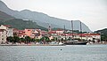 Makarska harbor
 -
 Karst cliffs
 -
 Chapel on Biokovo
 -
 Franjo Tuđman monument
 -
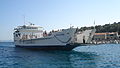 Pelješčanka ferry
 -
 Red semi-submarine in Makarska harbour


See also
References
This article needs additional citations for verification. (January 2011) |
Notes
- Wikidata Q119585703.
- ^ "Population by Age and Sex, by Settlements, 2021 Census". Census of Population, Households and Dwellings in 2021. Zagreb: Croatian Bureau of Statistics. 2022.
- ^ ISBN 953-178-097-8
- ^ Marušić 2017, p. 113.
- ^ Marušić 2017, pp. 114–115.
- ^ Marušić 2017, p. 115.
- ^ Marušić 2017, p. 122.
- ^ Nigel Thomas, K. Mikulan, Darko Pavlović. Axis Forces in Yugoslavia 1941-45, pg. 18, Osprey Publishing, 1995.
- ^ Admina, Admina (14 November 2020). "OKRUGLI STOL O URBANIZMU "Zgradurine kraj dvorane možda i nisu tako loše, ali ovdje ne pripadaju…" – Makarska Danas" (in Croatian). Retrieved 2020-11-21.
- ^ "Rezultati - Lokalni izbori". Makarsko Primorje (in Croatian). Archived from the original on 2021-05-31. Retrieved 2021-04-15.
- ^ "Zamjenica gradonačelnika". makarska.hr (in Croatian). Retrieved 2021-07-18.
- ^ "Gradsko vijeće". makarska.hr (in Croatian). Retrieved 2021-07-18.
- ^ "Population by Age and Sex, by Settlements, 2011 Census: Makarska". Census of Population, Households and Dwellings 2011. Zagreb: Croatian Bureau of Statistics. December 2012.
- ^ Grasgruber P, Prce S, Stračárová N, Hrazdíra E, Cacek J, Popović S, Hřebíčková S, Potpara P, Davidovič I, Kalina T. The coast of giants: an anthropometric survey of high schoolers on the Adriatic coast of Croatia. PeerJ. 2019 Apr 17;7:e6598. doi: 10.7717/peerj.6598. PMID 31024758; PMCID: PMC6475134. https://peerj.com/articles/6598/
- ^ French, Maddy (2014-02-28). "Chess champion Garry Kasparov granted Croatian citizenship". The Guardian.
Bibliography
- Marušić, Bartul (2017). "Opća i pravna povijest Makarske i primorja do austrijske vladavine" [General and legal history of Makarska and its littoral until Austrian rule] (PDF). Zbornik Radova Veleučilišta U Šibeniku (in Croatian) (3–4/2017): 111–131. Retrieved 6 May 2019.
Sources and external links
- . Encyclopædia Britannica (11th ed.). 1911.
- GCatholic - former cathedral
- Foster, Jane (3 June 2014). "Makarska, Croatia: Secret Seaside". The Telegraph. Retrieved 6 May 2019.
Subdivisions of Split-Dalmatia County | ||
|---|---|---|
| Cities and towns |  | |
| Municipalities |
| |
| International | |
|---|---|
| National | |
| Geographic | |