
Ares Vallis
 Mars Pathfinder (at 19.13 N, 33.22 W) photographed the region where Ares Vallis borders Chryse | |
| Coordinates | 10°24′N 25°48′W / 10.4°N 25.8°W |
|---|---|
| Length | 1,700 km (1,100 mi) |
Ares Vallis
Ares Vallis is in the Oxia Palus quadrangle of Mars.
It has been argued that
Research, published in January 2010, suggests that Mars had lakes, each around 20 km (12 mi) wide, along parts of the equator. Although earlier research showed that Mars had a warm and wet early history that has long since dried up, these lakes existed in the Hesperian Epoch, a much earlier period. Using detailed images from NASA's Mars Reconnaissance Orbiter, the researchers speculate that there may have been increased volcanic activity, meteorite impacts or shifts in Mars' orbit during this period to warm Mars' atmosphere enough to melt the abundant ice present in the ground. Volcanoes would have released gases that thickened the atmosphere for a temporary period, trapping more sunlight and making it warm enough for liquid water to exist. In this new study, channels were discovered that connected lake basins near Ares Vallis. When one lake filled up, its waters overflowed the banks and carved the channels to a lower area where another lake would form.[8][9] These lakes would be another place to look for evidence of present or past life.
-
 Quadrangle map of Oxia Palus labeled with major features. This quadrangle contains many collapsed areas of Chaos and many outflow channels (old river valleys). Ares Vallis is near bottom center.
 -
 Tography map of Oxia Palus region of Mars showing the location of a number of chaos regions and valleys, including Ares Vallis
 -
 Viking mosaic of the mouth of Ares Vallis. The image to the right is located in lower right of this image.
 -
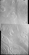
 Erosion features in Ares Vallis, as seen by THEMIS
 -
 Ares Vallis, as seen by Viking. The channel is 25 km (16 mi) wide and about 1 km (0.62 mi) deep.
 -
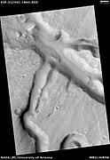 Channels in the Ares Vallis region, as seen by HiRISE.
 -
 Ares Vallis, as seen by HiRISE
 -
 A panoramic view of part of Ares Vallis taken by Mars Pathfinder


See also
- Chaos terrain
- Geology of Mars
- HiRISE
- Lakes on Mars
- List of areas of chaos terrain on Mars
- Martian chaos terrain
- Outburst flood
- Mars Pathfinder
- Outflow channels
- Uzboi-Landon-Morava (ULM)
References
- ^ Mars Express - Ancient floods on Mars: Iani Chaos and Ares Vallis, ESA, June 1, 2005
- ^ Parker, T.J., Clifford, S.m., and Banerdt, W.B. (2000). Argyre Planitia and the Mars global hydrologic cycle. LPSC XXXI, Abstract 2033.
- ^ Carr, M. 1979. Formation of Martian flood features by the release of water from confined aquifers. J. Geophys. Res. 84, 2995-3007.
- ^ Carr, M., G. Clow. 1981. Martian channels and valleys: their characteristics, distribution, and age. Icarus: 48 (1), 91-117.
- ^ Grant, J., T. Parker. 2002. Drainage evolution of the Margaritifer Sinus region, Mars. J. Geophys. Res. 107, doi:10.1029/2001JE001678.
- ^ Grant., J. et al. 2009. Geologic map of MTM-20012 and -25012 quadrangles, Margaritifer Terra region of Mars, U.S. Geol. Sur, Scientific Investigations Map 3041, scale 1:1,000,000.
- ^ Rotto, S., K. Tanaka. 1995. Geologic/Geomorphic map of the Chryse Planitia region of Mars, U.S. Geol. Surv. Invest. Ser. Map I-2441, scale 1:5M.
- ^ "Spectacular Mars Images Reveal Evidence of Ancient Lakes". ScienceDaily. January 4, 2010. Archived from the original on August 23, 2016. Retrieved March 9, 2018.
- doi:10.1130/G30579.1.
Further reading
- Baker, V.R.; Carr, M.H.; Gulick, V.C.; Williams, C.R. & Marley, M.S. "Channels and Valley Networks". In Kieffer, H.H.; Jakosky, B.M.; Snyder, C.W. & Matthews, M.S. (eds.). Mars. Tucson, AZ: University of Arizona Press.
- Carr, M.H. (1981). "Channels, Valleys and Gullies". The Surface of Mars. ISBN 978-0-521-87201-0.
External links
- Google Mars scrollable map - centered on Ares Vallis.
| Mars Pathfinder (Carl Sagan Memorial Station) |  | |
|---|---|---|
| Mars Pathfinder instruments | ||
| Key personnel | ||
| Related | ||
| International | |
|---|---|
| National | |