
Sakai
Sakai
堺市 | |
|---|---|
, Skyline with Daisen kofun in the center | |
 Flag  Seal | |
 Location of Sakai in Osaka Prefecture | |
 | |
 Sakai Location in Japan | |
| Coordinates: 34°34′24″N 135°28′59″E / 34.57333°N 135.48306°E | |
| Country | Japan |
| Region | Kansai |
| Prefecture | Osaka |
| Government | |
| • Mayor | Hideki Nagafuji (from June 2019) |
| Area | |
• Total | 149.82 km2 (57.85 sq mi) |
| Population (January 1, 2022) | |
• Total | 819,965 |
| • Density | 5,500/km2 (14,000/sq mi) |
| Time zone | UTC+09:00 (JST) |
| City hall address | 3-1 Minami-Kawaramachi, Sakai-ku, Sakai-shi, Osaka-fu 590-0078 |
| Climate | Cfa |
| Website | Official website |
| Symbols | |
| Bird | Shrike |
| Flower | Iris |
| Tree | Willow |
Sakai (堺市, Sakai-shi; Japanese pronunciation:
Geography
Sakai is located in southern Osaka Prefecture, on the edge of Osaka Bay and directly south of the city of Osaka.
Neighboring municipalities
Osaka Prefecture
Climate
Sakai has a Humid subtropical climate (Köppen Cfa) characterized by warm summers and cool winters with light to no snowfall. The average annual temperature in Sakai is 16.5 °C (61.7 °F). The average annual rainfall is 1,232.9 mm (48.54 in) with June as the wettest month. The temperatures are highest on average in August, at around 28.6 °C (83.5 °F), and lowest in January, at around 5.6 °C (42.1 °F).[4]
| Climate data for Sakai (1991−2020 normals, extremes 1977−present) | |||||||||||||
|---|---|---|---|---|---|---|---|---|---|---|---|---|---|
| Month | Jan | Feb | Mar | Apr | May | Jun | Jul | Aug | Sep | Oct | Nov | Dec | Year |
| Record high °C (°F) | 19.1 (66.4) |
23.9 (75.0) |
27.5 (81.5) |
30.2 (86.4) |
33.0 (91.4) |
36.3 (97.3) |
37.9 (100.2) |
39.7 (103.5) |
36.8 (98.2) |
32.7 (90.9) |
27.5 (81.5) |
25.5 (77.9) |
39.7 (103.5) |
| Mean daily maximum °C (°F) | 9.6 (49.3) |
10.5 (50.9) |
14.3 (57.7) |
20.0 (68.0) |
24.9 (76.8) |
28.1 (82.6) |
32.0 (89.6) |
33.9 (93.0) |
29.6 (85.3) |
23.6 (74.5) |
17.8 (64.0) |
12.3 (54.1) |
21.4 (70.5) |
| Daily mean °C (°F) | 5.6 (42.1) |
6.0 (42.8) |
9.3 (48.7) |
14.6 (58.3) |
19.4 (66.9) |
23.1 (73.6) |
27.2 (81.0) |
28.6 (83.5) |
24.6 (76.3) |
18.6 (65.5) |
12.9 (55.2) |
7.9 (46.2) |
16.5 (61.7) |
| Mean daily minimum °C (°F) | 1.6 (34.9) |
1.7 (35.1) |
4.5 (40.1) |
9.3 (48.7) |
14.4 (57.9) |
19.1 (66.4) |
23.4 (74.1) |
24.5 (76.1) |
20.6 (69.1) |
14.3 (57.7) |
8.4 (47.1) |
3.9 (39.0) |
12.1 (53.8) |
| Record low °C (°F) | −5.0 (23.0) |
−5.3 (22.5) |
−3.3 (26.1) |
−1.1 (30.0) |
4.1 (39.4) |
9.1 (48.4) |
15.5 (59.9) |
16.6 (61.9) |
9.7 (49.5) |
2.7 (36.9) |
−0.9 (30.4) |
−3.4 (25.9) |
−5.3 (22.5) |
| Average precipitation mm (inches) | 48.3 (1.90) |
57.8 (2.28) |
97.8 (3.85) |
92.2 (3.63) |
126.7 (4.99) |
164.1 (6.46) |
154.2 (6.07) |
87.3 (3.44) |
139.0 (5.47) |
139.3 (5.48) |
74.6 (2.94) |
51.9 (2.04) |
1,232.9 (48.54) |
| Average precipitation days (≥ 1.0mm) | 6.4 | 6.9 | 9.5 | 9.3 | 9.6 | 11.8 | 10.3 | 6.6 | 10.0 | 8.9 | 6.8 | 6.6 | 102.6 |
| Mean monthly sunshine hours | 138.3 | 138.7 | 173.5 | 194.6 | 206.9 | 160.6 | 190.6 | 228.6 | 160.4 | 163.0 | 147.5 | 138.7 | 2,041.4 |
| Source: Japan Meteorological Agency[4][5] | |||||||||||||
Demographics
According to Japanese census data,[6] the population of Sakai increased rapidly in the 1960s and 1970s, and has been relatively stable since.
| Year | Pop. | ±% |
|---|---|---|
| 1960 | 383,559 | — |
| 1970 | 616,558 | +60.7% |
| 1980 | 839,421 | +36.1% |
| 1990 | 844,899 | +0.7% |
| 2000 | 829,636 | −1.8% |
| 2010 | 842,132 | +1.5% |
| 2020 | 826,161 | −1.9% |
History
Origins
The area that would later become known as Sakai has been inhabited since approximately 8,000 BC.
Tradition holds that 10,000 homes burned to the ground in 1399.[8]
-
 Daisen Kofun
 -

-

-


Feudal period
Medieval Sakai was an autonomous city run by merchant oligarchs. During the Muromachi and Sengoku periods from about 1450 to 1600, Sakai developed into one of richest cities in Japan as a port for foreign trade. It was a leading producer of textiles and ironwork.[9] In those days, it was said that the richest cities were Umi no Sakai, Riku no Imai (tr. "along the sea, Sakai; inlands, Imai"; the latter is now a part of Kashihara, Nara). The famous Zen Buddhist priest Ikkyū chose to live in Sakai because of its free atmosphere. The first reliable account of the city is dated to the 1480s and contains publicly issued legal notices, which suggests that the city had a governing council at that point. By the 1530s, the population was around 40,000 residents, almost all of which earned a living through commercial enterprises and some of whom were the wealthiest people in Japan. At this time, Sakai was administered by an oligarchy of powerful merchants. The government had ten divisions machi that were subordinate to the representative council of wealthy townsmen known as the egōshū.[9][10]
Sen no Rikyū, known as the greatest master of the tea ceremony, was originally a merchant of Sakai. Because of the close relationship between the tea ceremony and Zen Buddhism and because of the prosperity of its citizens, Sakai was one of the main centers of the tea ceremony in Japan.
In the Sengoku period, Christian missionaries, including Francis Xavier in 1550, visited Sakai and documented its prosperity. Gaspar Vilela described the town as the safest place in the area when he visited in 1561.[11] He also mentioned that the city was "governed by consuls like Venice in Italy".[9][12]
After the coming of Europeans, Sakai became a manufacturing base of
After the assassination of Nobunaga in 1582, Toyotomi Hideyoshi, seized power and abolished the autonomous system of Sakai, forcing many merchants to move to his stronghold in Osaka.[13]
-
 Old house of gunsmiths in Sakai
 -
 Gunsmith storefront in Sakai, Osaka
 -


Edo period
In 1615, Sakai was razed to the ground in the summer campaign of the Siege of Osaka between the Toyotomi clan and Tokugawa Ieyasu.[8]
Sakai was restored as an important trade center during the
-
 Sakai incident (1868)

Modern Sakai
Following the
Government
Sakai has a
Local administration
Sakai has seven wards (ku):
| Wards of Sakai | |||||||
|---|---|---|---|---|---|---|---|
| Place Name | Map of Sakai | ||||||
| Rōmaji | Kanji | Population | Land area in km2 | Pop. density per km2 | |||
| 1 | Sakai-ku (administrative center) | 堺区 | 148,353 | 23.66 | 6,270 |  | |
| 2 | Higashi-ku | 東区 | 84,708 | 10.49 | 8,075 | ||
| 3 | Kita-ku | 北区 | 159,084 | 15.60 | 10,198 | ||
| 4 | Naka-ku | 中区 | 120,216 | 17.88 | 6,723 | ||
| 5 | Nishi-ku | 西区 | 134,389 | 28.62 | 4,696 | ||
| 6 | Mihara-ku | 美原区 | 37,223 | 13.20 | 2,820 | ||
| 7 | Minami-ku | 南区 | 135,992 | 40.39 | 3,367 | ||
Cityscape
- Gallery
-
 Sakai City Downtown (2020)
 -
 Sakai City Skyline (2020)
 -
 Old Sakai Port (2020)
 -
 Daisen Park (2019)
 -
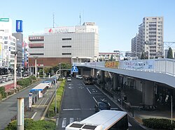 Sakaihigashi Station (2016)
 -
 Sakai City Hall (2024)


.jpg)


Economy
Sakai was traditionally dependent on heavy industry and its port. However, after a period of high economic growth after World War II, along with the development and expansion of the Osaka metropolitan area, Sakai also has increasingly become a satellite city (commuter town) for Osaka metropolis, as represented by the development of Senboku New Town. Shimano, a major manufacturer of cycling and fishing products, is based in Sakai.
Kura Sushi, the conveyor belt sushi chain, has its headquarters in Sakai.[15]
Education

Universities
- Hagoromo International University
- Kansai University Sakai Campus
- Osaka Butsuryo University
- Osaka Junior College of Social Health and Welfare
- Osaka Prefecture University
- Poole Gakuin University
- Sakai Women's Junior College
- Taisei Gakuin University
- Tezukayama Gakuin University
Primary and secondary schools
Sakai has 98 public elementary schools and 43 public middle schools operated by the city government. The city also has one private elementary school, three private combined middle/high schools and one private combined elementary/middle/high school. The city has 23 public high schools operated by the Osaka Prefectural Board of Education, and four private high schools. The city operates two and the prefecture operates four special education schools for the disabled.
The city previously had a
Transportation


Airways
Airport
Sakai does not have an airport. The nearest major airport is Kansai International Airport.
Railways
![]() Nankai Electric Railway -
Nankai Electric Railway - ![]() Nankai Main Line
Nankai Main Line
- Shichidō - Sakai - Minato - Ishizugawa - Suwanomori - Hamaderakōen
- Asakayama - Sakaihigashi - Mikunigaoka - Mozuhachiman - Nakamozu - Shirasagi - Hatsushiba - Hagiharatenjin - Kitanoda
![]() Nankai Electric Railway -
Nankai Electric Railway - ![]() Semboku Line
Semboku Line
- Nakamozu - Fukai - Izumigaoka - Toga-Mikita - Kōmyōike
Subway
Tramway
- Hankai Line: (Sumiyoshi)- Yamatogawa - Takasu-jinsha - Ayanocho - Shimmeicho - Myokokuji-mae - Hanataguchi - Oshoji - Shukuin - Terajicho - Goryomae - Higashi-Minato - Ishizu-Kita - Ishizu - Funao - Hamaderakōen
Bus
Highways
Expressways
Japan National Route
International relations
Sister cities
 Berkeley, California, United States, since 1967
 Lianyungang, Jiangsu, China, since 1983
 Wellington, New Zealand, since 1994
Friendship cities
 Tanegashima, Kagoshima, Japan, since 1986
- Higashiyoshino, Nara, Japan, since 1986
 Da Nang, Vietnam , since 2019
Notable people from Sakai
- entertainer.
- entertainer
- glamour modeland actress
- Emperor Nintoku, the 16th Emperor of Japan
- Buddhist priest of the Nara period
- Buddhist monkand poet.
- Sen no Rikyū, Japanese tea master
- Tsuda Sōgyū, Japanese tea master
- Imai Sōkyū, Japanese tea master and merchant
- Ōuchi Yoshihiro, Muromachi period samurai clan head and military leader
- Kenzō Tange, Japanese award-winning architect
- Takeno Jōō
- Oreskaband, all-female ska band
- Kana-Boon, Japanese rock band
- kickboxer
- Hiroki Suzuki, Japanese actor and singer
- Kentaro Kobuchi and Shunsuke Kuroda, the members of the music group Kobukuro
- Akiko Yosano, poet and novelist
- Ryumon Yasuda, painter and sculptor
- Kintetsu Buffaloes
- manga artistduo (attended Hatsushiba High School in Higashi-ku)
- Akio Mori, a well known K-1 kickboxer known as Musashi (kickboxer)
- Akira Nagata, actor and singer/vocalist, member of J-pop group Run&Gun
- professional wrestler
- Fuka Koshiba, Japanese actress
- Peter, Japanese singer, dancer and actor
- Ayumi Beppu, Japanese actress
- Yuta Fujiwara, Japanese racing driver
Local attractions
- Mozu Kofun Cluster
- Kurohimeyama Kofun
- Yotsu-ike Site
- Dotō
- Sakai City Museum
- Sakai Matsuri
- Tsukuno Danjiri Matsuri
See also
- Osaka Metropolis plan
References
- ^ Sakai official English name Archived February 26, 2010, at the Wayback Machine
- ^ NHK Broadcasting Culture Research Institute, ed. (May 24, 2016). NHK日本語発音アクセント新辞典 (in Japanese). NHK Publishing.
- ^ "Sakai city official statistics" (in Japanese). Japan.
- ^ a b "平年値(年・月ごとの値)". JMA. Retrieved May 19, 2021.
- ^ "観測史上1~10位の値(年間を通じての値)". JMC. Retrieved August 10, 2012.
- ^ Sakai population statistics
- ^ a b "Welcome to Sakai!".
- ^ a b c "History".
- ^ ISBN 978-0-19-163769-8.
- ^ Katsurō Hara (1920). An Introduction to the History of Japan. G. P. Putnams' sons.
- ^ "Sakai: A keyhole to the history of Osaka". April 11, 2015.
- ^ "Japan's oldest 'autonomous' city splits over Osaka Metropolis Plan – Xinhua | English.news.cn". news.xinhuanet.com. Archived from the original on September 24, 2013. Retrieved May 8, 2016.
- ^ "Japan's oldest "autonomous" city splits over Osaka Metropolis Plan - Xinhua | English.news.cn". news.xinhuanet.com. Archived from the original on September 24, 2013.
- ^ "Tokyo pollsters in the money", Yomiuri Shimbun, February 17, 2007. Accessed March 13, 2007.
- ^ "Company". Kura Sushi. Retrieved June 11, 2022.
1-2-1 Fukasaka, Naka-ku, Sakai-shi, Osaka 599-8253, Japan
- Address in Japanese: "大阪府堺市中区深阪1-2-2" - ^ ウリハッキョ一覧. Chongryon. November 6, 2005. Archived from the original on November 6, 2005. Retrieved October 15, 2015. (Archive).
External links
- Sakai City official website (in Japanese)
 Sakai travel guide from Wikivoyage
 Geographic data related to Sakai at OpenStreetMap
| International | |
|---|---|
| National | |
| Geographic | |
| Academics | |