
Tazewell County, Illinois
Tazewell County | |
|---|---|
 Tazewell County Courthouse in Pekin | |
|
UTC−5 (CDT) | |
| Congressional districts | 16th, 17th |
| Website | www |
Tazewell County ( It is pronounced with a short "a", to rhyme with "razz" rather than "raze."
Tazewell County is part of the
History
Tazewell County was formed out of
The first county seat was in Mackinaw from 1827 to 1836.[3][4] It was moved temporarily from Mackinaw to Pekin in June 1831, with the county court proceedings in the Snell schoolhouse.[3][4] It moved to Tremont in 1836.[3][5] After a political struggle between Tremont and Pekin, the county seat was reassigned to Pekin in 1849.[3]
-
![Tazewell from the time of its creation to 1829, including a large tract of unorganized territory temporarily attached to it, whose precise border was not defined.[6]](//upload.wikimedia.org/wikipedia/commons/thumb/e/e0/Tazewell_County_Illinois_1827.png/85px-Tazewell_County_Illinois_1827.png) Tazewell from the time of its creation to 1829, including a large tract of unorganized territory temporarily attached to it, whose precise border was not defined.[6]
Tazewell from the time of its creation to 1829, including a large tract of unorganized territory temporarily attached to it, whose precise border was not defined.[6] -
 Tazewell County between 1829 and 1830: the creation of Macon County established a southern border for Tazewell's additional territory.
 -
 Tazewell County between 1830 and 1831: the additional territory to the east became McLean County.
 -
 Tazewell County between 1831 and 1841: the last of the county's additional territory became part of LaSalle County.
 -
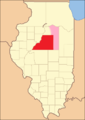
 Tazewell County in 1841, reduced to its present borders.
![Tazewell from the time of its creation to 1829, including a large tract of unorganized territory temporarily attached to it, whose precise border was not defined.[6]](/File:Tazewell_County_Illinois_1827.png)


Geography
According to the
State Fish & Wildlife Areas
The following Illinois State Park & Natural Areas are located in Tazewell County:[8]
- Spring Lake State Fish and Wildlife Area - an 8.5-mile (13.7 km) long alluvial lake that lies parallel to the Illinois River.
- Powerton Lake State Fish and Wildlife Area - 1,426-acre (577 ha) area of semi-protected habitat on the Illinois River.
- Mackinaw River State Fish and Wildlife Area - 1,448-acre (586 ha) state park
Climate and weather
| Pekin, Illinois | ||||||||||||||||||||||||||||||||||||||||||||||||||||||||||||
|---|---|---|---|---|---|---|---|---|---|---|---|---|---|---|---|---|---|---|---|---|---|---|---|---|---|---|---|---|---|---|---|---|---|---|---|---|---|---|---|---|---|---|---|---|---|---|---|---|---|---|---|---|---|---|---|---|---|---|---|---|
| Climate chart (explanation) | ||||||||||||||||||||||||||||||||||||||||||||||||||||||||||||
| ||||||||||||||||||||||||||||||||||||||||||||||||||||||||||||
| ||||||||||||||||||||||||||||||||||||||||||||||||||||||||||||
In recent years, average temperatures in the county seat of Pekin have ranged from a low of 14 °F (−10 °C) in January to a high of 86 °F (30 °C) in July, although a record low of −27 °F (−33 °C) was recorded in January 1884 and a record high of 113 °F (45 °C) was recorded in July 1936. Average monthly precipitation ranged from 1.50 inches (38 mm) in January to 4.17 inches (106 mm) in May.[9]
Adjacent counties
- Peoria County (northwest)
- Woodford County (north)
- McLean County (east)
- Logan County (south)
- Mason County (southwest)
- Fulton County (west)
Transportation
Major highways
 Interstate 74
 Interstate 155
 Interstate 474
- U.S. Highway 24
- U.S. Highway 150
 Illinois Route 8
 Illinois Route 9
 Illinois Route 29
 Illinois Route 40
 Illinois Route 98
 Illinois Route 116
 Illinois Route 122
Airports
The following public-use airports are located in Tazewell County:[10]
- Pekin Municipal Airport (C15) - serves Pekin (Located by the Village of South Pekin, Illinois)
- Manito Mitchell Airport (C45) - serves Manito, a village in Mason County
Public Transportation
Bus and paratransit service in Tazewell County is provided by Peoria's “CityLink” system, operating six routes (four originating from Peoria) seven days a week.
Demographics
| Census | Pop. | Note | %± |
|---|---|---|---|
| 1830 | 4,716 | — | |
| 1840 | 7,221 | 53.1% | |
| 1850 | 12,052 | 66.9% | |
| 1860 | 21,470 | 78.1% | |
| 1870 | 27,903 | 30.0% | |
| 1880 | 29,666 | 6.3% | |
| 1890 | 29,556 | −0.4% | |
| 1900 | 33,221 | 12.4% | |
| 1910 | 34,027 | 2.4% | |
| 1920 | 38,540 | 13.3% | |
| 1930 | 46,082 | 19.6% | |
| 1940 | 58,362 | 26.6% | |
| 1950 | 76,165 | 30.5% | |
| 1960 | 99,789 | 31.0% | |
| 1970 | 118,649 | 18.9% | |
| 1980 | 132,078 | 11.3% | |
| 1990 | 123,692 | −6.3% | |
| 2000 | 128,485 | 3.9% | |
| 2010 | 135,394 | 5.4% | |
| 2020 | 131,343 | −3.0% | |
| 2023 (est.) | 129,541 | [11] | −1.4% |
| U.S. Decennial Census[12] 1790-1960[13] 1900-1990[14] 1990-2000[15] 2010[16] | |||
As of the
Of the 54,146 households, 31.4% had children under the age of 18 living with them, 54.2% were married couples living together, 10.2% had a female householder with no husband present, 31.4% were non-families, and 26.3% of all households were made up of individuals. The average household size was 2.45 and the average family size was 2.94. The median age was 39.8 years.[17]
The median income for a household in the county was $54,232 and the median income for a family was $66,764. Males had a median income of $50,372 versus $34,747 for females. The per capita income for the county was $27,036. About 6.3% of families and 7.9% of the population were below the
Communities
Cities
Villages
Census-designated place
Other unincorporated communities
Townships
Tazewell County is divided into these townships:
Politics
Tazewell County has been solidly Republican on the national level, voting for the Republican candidate for U.S. president since 1996 and in all but two elections since 1952.
For the purposes of Illinois law, as of the 2022 general primary election, the three established political parties in the county are the Democratic Party, the Republican Party, and the Libertarian Party as all have received 5% or greater of the vote in a recent election. A relative rarity, Tazewell is one of only five counties where the Libertarian Party was an established political party in 2022.[20] The Libertarian Party's established established political party status allows it to have the same reduced barriers to ballot access as the Democratic and Republican parties and to hold primary elections.[21] In the 2022 primary, 20 voters requested a Libertarian primary ballot.[20]
| Year | Republican | Democratic | Third party | |||
|---|---|---|---|---|---|---|
| No. | % | No. | % | No. | % | |
| 2020 | 42,513 | 61.37% | 24,819 | 35.83% | 1,944 | 2.81% |
| 2016 | 38,707 | 59.78% | 20,685 | 31.95% | 5,359 | 8.28% |
| 2012 | 35,335 | 57.66% | 24,438 | 39.88% | 1,509 | 2.46% |
| 2008 | 33,247 | 51.90% | 29,384 | 45.87% | 1,429 | 2.23% |
| 2004 | 36,058 | 57.84% | 25,814 | 41.41% | 466 | 0.75% |
| 2000 | 31,537 | 54.05% | 25,379 | 43.50% | 1,432 | 2.45% |
| 1996 | 24,395 | 45.45% | 24,139 | 44.97% | 5,144 | 9.58% |
| 1992 | 23,469 | 39.12% | 26,428 | 44.05% | 10,097 | 16.83% |
| 1988 | 28,861 | 53.72% | 24,603 | 45.79% | 263 | 0.49% |
| 1984 | 33,782 | 59.15% | 23,095 | 40.44% | 238 | 0.42% |
| 1980 | 35,481 | 62.84% | 16,924 | 29.97% | 4,057 | 7.19% |
| 1976 | 28,951 | 55.14% | 22,821 | 43.47% | 731 | 1.39% |
| 1972 | 31,937 | 67.08% | 15,576 | 32.71% | 100 | 0.21% |
| 1968 | 22,971 | 47.44% | 20,712 | 42.77% | 4,739 | 9.79% |
| 1964 | 17,170 | 37.55% | 28,561 | 62.45% | 0 | 0.00% |
| 1960 | 23,967 | 53.83% | 20,521 | 46.09% | 38 | 0.09% |
| 1956 | 23,690 | 59.27% | 16,230 | 40.61% | 50 | 0.13% |
| 1952 | 20,763 | 55.14% | 16,862 | 44.78% | 28 | 0.07% |
| 1948 | 12,504 | 46.70% | 14,131 | 52.77% | 143 | 0.53% |
| 1944 | 12,531 | 46.34% | 14,412 | 53.30% | 96 | 0.36% |
| 1940 | 12,419 | 41.18% | 17,624 | 58.44% | 116 | 0.38% |
| 1936 | 7,946 | 32.07% | 16,487 | 66.55% | 341 | 1.38% |
| 1932 | 7,260 | 34.48% | 13,591 | 64.55% | 204 | 0.97% |
| 1928 | 9,409 | 56.73% | 6,910 | 41.66% | 267 | 1.61% |
| 1924 | 7,488 | 52.11% | 3,375 | 23.49% | 3,507 | 24.41% |
| 1920 | 7,679 | 62.69% | 3,640 | 29.71% | 931 | 7.60% |
| 1916 | 6,672 | 47.56% | 6,743 | 48.07% | 613 | 4.37% |
| 1912 | 2,500 | 32.40% | 3,654 | 47.35% | 1,563 | 20.25% |
| 1908 | 3,767 | 47.55% | 3,786 | 47.78% | 370 | 4.67% |
| 1904 | 4,051 | 52.41% | 3,255 | 42.11% | 423 | 5.47% |
| 1900 | 3,957 | 48.05% | 4,048 | 49.16% | 230 | 2.79% |
| 1896 | 3,703 | 48.72% | 3,743 | 49.24% | 155 | 2.04% |
| 1892 | 3,030 | 43.63% | 3,652 | 52.59% | 262 | 3.77% |
See also
Notable people
- Charles "Buffalo" Jones, Cowboy and Naturalist
- Everett DirksonUS Senator
- Gary Richrath, Lead Guitarist - REO Speedwagon
- John Theodore McNaughton, Government Official
References
- ^ "Tazewell County, Illinois". United States Census Bureau. Retrieved June 10, 2023.
- ^ "Find a County". National Association of Counties. Retrieved June 7, 2011.
- ^ JSTOR 40190022.
- ^ a b Williams, Frank J.; Williams, Virginia; Bates, William Henry. "Souvenir of Early and Notable Events in the History of the North West Territory, Illinois, and Tazewell County, including the Names of those who have Served the County in Various Official Capacities". Document.
- ^ "When Pekin was only a town". From the History Room. April 20, 2018. Retrieved November 7, 2023.
- ^ White, Jesse. Origin and Evolution of Illinois Counties. State of Illinois, March 2010. [1]
- ^ a b "Population, Housing Units, Area, and Density: 2010 - County". United States Census Bureau. Archived from the original on February 12, 2020. Retrieved July 12, 2015.
- ^ "Illinois Department of Natural Resources". Illinois Department of Natural Resources Home. Retrieved March 20, 2024.
- ^ a b "Monthly Averages for Pekin, Illinois". The Weather Channel. Retrieved January 27, 2011.
- ^ "Tazewell County Public and Private Airports". www.tollfreeairline.com. Retrieved March 19, 2018.
- ^ "Annual Estimates of the Resident Population for Counties: April 1, 2020 to July 1, 2023". United States Census Bureau. Retrieved April 2, 2024.
- ^ "U.S. Decennial Census". United States Census Bureau. Retrieved July 9, 2014.
- ^ "Historical Census Browser". University of Virginia Library. Retrieved July 9, 2014.
- ^ "Population of Counties by Decennial Census: 1900 to 1990". United States Census Bureau. Retrieved July 9, 2014.
- ^ "Census 2000 PHC-T-4. Ranking Tables for Counties: 1990 and 2000" (PDF). United States Census Bureau. Retrieved July 9, 2014.
- ^ "State & County QuickFacts". United States Census Bureau. Archived from the original on June 7, 2011. Retrieved July 9, 2014.
- ^ a b c "DP-1 Profile of General Population and Housing Characteristics: 2010 Demographic Profile Data". United States Census Bureau. Archived from the original on February 13, 2020. Retrieved July 12, 2015.
- ^ "DP02 SELECTED SOCIAL CHARACTERISTICS IN THE UNITED STATES – 2006-2010 American Community Survey 5-Year Estimates". United States Census Bureau. Archived from the original on February 13, 2020. Retrieved July 12, 2015.
- ^ "DP03 SELECTED ECONOMIC CHARACTERISTICS – 2006-2010 American Community Survey 5-Year Estimates". United States Census Bureau. Archived from the original on February 13, 2020. Retrieved July 12, 2015.
- ^ a b Matthews, Bernadette M. (Executive Director), ed. (July 29, 2022). Official Canvass of the Primary Election of June 28, 2022. Springfield, Illinois: Illinois State Board of Elections. p. vii. Retrieved January 4, 2024.
- ^ Matthews, Bernadette M. (Executive Director), ed. (October 6, 2023). 2024 Candidate's Guide. Springfield, Illinois: Illinois State Board of Elections. p. 15. Retrieved January 4, 2024.
- ^ Leip, David. "Dave Leip's Atlas of U.S. Presidential Elections". uselectionatlas.org. Retrieved March 19, 2018.
Places adjacent to Tazewell County, Illinois | ||||||||||||||||
|---|---|---|---|---|---|---|---|---|---|---|---|---|---|---|---|---|
| ||||||||||||||||
 | ||||
Villages | ||||
| Townships | ||||
| CDP | ||||
| Other unincorporated communities | ||||
| Footnotes | ‡This populated place also has portions in an adjacent county or counties | |||
| ||||
| International | |
|---|---|
| National | |
| Geographic | |
| Other | |