
Mercer County, Illinois
Mercer County | |
|---|---|
UTC−5 (CDT) | |
| Congressional districts | 15th, 17th |
| Website | www |
Mercer County is a
Mercer County is included in the Davenport-Moline-Rock Island, IA-IL Metropolitan Statistical Area.[3]
History
Mercer County is named for Hugh Mercer (1726–1777), a physician and general during the American Revolution who died from wounds suffered at the Battle of Princeton.
In May 1812, Congress passed an act which set aside lands in Arkansas, Michigan, and Illinois as payment to volunteer soldiers in the War of 1812. Mercer County was part of this "Military Tract."
Seven years after Illinois became a state, Mercer County was founded. It was formed from unorganized territory near Pike County on January 13, 1825. Although the county had been created, its government was not organized for several years; for administration purposes it was attached first to Schuyler County (until 1826), then to Peoria (until 1831), and finally to Warren County. The organization of the county government was finally completed in 1835, after a large influx of settlers following the Black Hawk War.[4]
-
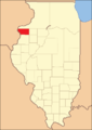
 Mercer County at the time of its creation in 1825
 -
 Mercer County in 1827, reduced to its present borders


Geography
According to the
Climate and weather
| Aledo, Illinois | ||||||||||||||||||||||||||||||||||||||||||||||||||||||||||||
|---|---|---|---|---|---|---|---|---|---|---|---|---|---|---|---|---|---|---|---|---|---|---|---|---|---|---|---|---|---|---|---|---|---|---|---|---|---|---|---|---|---|---|---|---|---|---|---|---|---|---|---|---|---|---|---|---|---|---|---|---|
| Climate chart (explanation) | ||||||||||||||||||||||||||||||||||||||||||||||||||||||||||||
| ||||||||||||||||||||||||||||||||||||||||||||||||||||||||||||
| ||||||||||||||||||||||||||||||||||||||||||||||||||||||||||||
In recent years, average temperatures in the county seat of Aledo have ranged from a low of 11 °F (−12 °C) in January to a high of 84 °F (29 °C) in July, although a record low of −30 °F (−34 °C) was recorded in February 1905 and a record high of 113 °F (45 °C) was recorded in July 1936. Average monthly precipitation ranged from 1.27 inches (32 mm) in January to 4.43 inches (113 mm) in June.[6]
Major highways
- U.S. Highway 67
 Illinois Route 17
 Illinois Route 94
 Illinois Route 135
Adjacent counties
- Rock Island County - north
- Henry County - east
- Knox County - southeast
- Henderson County - south
- Warren County - south
- Des Moines County, Iowa - southwest
- Louisa County, Iowa - west
Demographics
| Census | Pop. | Note | %± |
|---|---|---|---|
| 1830 | 26 | — | |
| 1840 | 2,352 | 8,946.2% | |
| 1850 | 5,246 | 123.0% | |
| 1860 | 15,042 | 186.7% | |
| 1870 | 18,769 | 24.8% | |
| 1880 | 19,502 | 3.9% | |
| 1890 | 18,545 | −4.9% | |
| 1900 | 20,945 | 12.9% | |
| 1910 | 19,723 | −5.8% | |
| 1920 | 18,800 | −4.7% | |
| 1930 | 16,641 | −11.5% | |
| 1940 | 17,701 | 6.4% | |
| 1950 | 17,374 | −1.8% | |
| 1960 | 17,149 | −1.3% | |
| 1970 | 17,294 | 0.8% | |
| 1980 | 19,286 | 11.5% | |
| 1990 | 17,290 | −10.3% | |
| 2000 | 16,957 | −1.9% | |
| 2010 | 16,434 | −3.1% | |
| 2020 | 15,699 | −4.5% | |
| 2023 (est.) | 15,487 | [7] | −1.4% |
| U.S. Decennial Census[8] 1790-1960[9] 1900-1990[10] 1990-2000[11] 2010[12] | |||
As of the
Of the 6,734 households, 30.1% had children under the age of 18 living with them, 58.3% were married couples living together, 7.9% had a female householder with no husband present, 29.8% were non-families, and 25.8% of all households were made up of individuals. The average household size was 2.41 and the average family size was 2.88. The median age was 43.7 years.[13]
The median income for a household in the county was $50,909 and the median income for a family was $62,025. Males had a median income of $46,136 versus $30,392 for females. The per capita income for the county was $25,332. About 8.2% of families and 9.3% of the population were below the
Communities
Cities
Villages
- Alexis
- Joy
- Matherville
- North Henderson
- Reynolds (Part in Rock Island County)
- Seaton
- Sherrard
- Viola
- Windsor
Unincorporated communities
Townships
Mercer County is divided into fifteen townships:
Politics
Historically, Mercer County was a solidly Republican Yankee-influenced county, and before the Republican Party existed a stronghold of the
Mercer County is located in Illinois's 17th Congressional District and is currently represented by Democrat Cheri Bustos. Within the Illinois House of Representatives, the county is located in the 74th district and is currently represented by Republican Daniel Swanson. The county is located in the 37th district of the Illinois Senate, and is currently represented by Republican Chuck Weaver.
| Year | Republican | Democratic | Third party | |||
|---|---|---|---|---|---|---|
| No. | % | No. | % | No. | % | |
| 2020 | 5,418 | 60.78% | 3,280 | 36.80% | 216 | 2.42% |
| 2016 | 4,807 | 56.39% | 3,071 | 36.02% | 647 | 7.59% |
| 2012 | 3,876 | 45.24% | 4,507 | 52.60% | 185 | 2.16% |
| 2008 | 3,833 | 43.21% | 4,887 | 55.10% | 150 | 1.69% |
| 2004 | 4,405 | 49.09% | 4,512 | 50.28% | 57 | 0.64% |
| 2000 | 3,688 | 44.34% | 4,400 | 52.90% | 230 | 2.77% |
| 1996 | 2,688 | 34.04% | 4,278 | 54.17% | 931 | 11.79% |
| 1992 | 2,983 | 34.93% | 3,990 | 46.72% | 1,567 | 18.35% |
| 1988 | 3,683 | 46.45% | 4,204 | 53.02% | 42 | 0.53% |
| 1984 | 4,907 | 54.97% | 3,982 | 44.61% | 38 | 0.43% |
| 1980 | 5,144 | 56.18% | 3,361 | 36.71% | 651 | 7.11% |
| 1976 | 4,816 | 53.62% | 4,090 | 45.54% | 76 | 0.85% |
| 1972 | 5,452 | 60.98% | 3,477 | 38.89% | 11 | 0.12% |
| 1968 | 4,844 | 56.33% | 3,143 | 36.55% | 613 | 7.13% |
| 1964 | 4,220 | 48.90% | 4,410 | 51.10% | 0 | 0.00% |
| 1960 | 5,582 | 61.60% | 3,476 | 38.36% | 3 | 0.03% |
| 1956 | 5,732 | 65.82% | 2,969 | 34.10% | 7 | 0.08% |
| 1952 | 6,416 | 70.53% | 2,679 | 29.45% | 2 | 0.02% |
| 1948 | 5,267 | 62.55% | 3,117 | 37.02% | 36 | 0.43% |
| 1944 | 5,667 | 63.12% | 3,277 | 36.50% | 34 | 0.38% |
| 1940 | 6,336 | 62.09% | 3,830 | 37.53% | 38 | 0.37% |
| 1936 | 5,028 | 50.87% | 4,751 | 48.07% | 105 | 1.06% |
| 1932 | 4,436 | 50.21% | 4,309 | 48.77% | 90 | 1.02% |
| 1928 | 5,699 | 70.59% | 2,316 | 28.69% | 58 | 0.72% |
| 1924 | 5,618 | 68.30% | 1,699 | 20.66% | 908 | 11.04% |
| 1920 | 5,531 | 74.58% | 1,574 | 21.22% | 311 | 4.19% |
| 1916 | 5,308 | 58.93% | 3,430 | 38.08% | 270 | 3.00% |
| 1912 | 959 | 19.20% | 1,602 | 32.07% | 2,435 | 48.74% |
| 1908 | 2,871 | 57.51% | 1,777 | 35.60% | 344 | 6.89% |
| 1904 | 3,230 | 63.65% | 1,386 | 27.31% | 459 | 9.04% |
| 1900 | 3,304 | 59.39% | 2,110 | 37.93% | 149 | 2.68% |
| 1896 | 3,120 | 56.48% | 2,329 | 42.16% | 75 | 1.36% |
| 1892 | 2,470 | 52.70% | 1,975 | 42.14% | 242 | 5.16% |
See also
Footnotes
- ^ "Mercer County, Illinois". United States Census Bureau. Retrieved June 10, 2023.
- ^ "Find a County". National Association of Counties. Retrieved June 7, 2011.
- United States Office of Management and Budget. "Update of Statistical Area Definitions and Guidance on Their Uses" (PDF). pp. 5, 36. Archived from the original(PDF) on May 14, 2006. Retrieved July 21, 2006.
- ^ Mercer County Fact Sheet, Illinois State Archives. "Mercer County Fact Sheet". Archived from the original on October 23, 2007. Retrieved October 23, 2007.
- ^ a b "Population, Housing Units, Area, and Density: 2010 - County". United States Census Bureau. Archived from the original on February 12, 2020. Retrieved July 12, 2015.
- ^ a b "Monthly Averages for Aledo, Illinois". The Weather Channel. Retrieved January 27, 2011.
- ^ "Annual Estimates of the Resident Population for Counties: April 1, 2020 to July 1, 2023". United States Census Bureau. Retrieved April 2, 2024.
- ^ "U.S. Decennial Census". United States Census Bureau. Retrieved July 7, 2014.
- ^ "Historical Census Browser". University of Virginia Library. Retrieved July 7, 2014.
- ^ "Population of Counties by Decennial Census: 1900 to 1990". United States Census Bureau. Retrieved July 7, 2014.
- ^ "Census 2000 PHC-T-4. Ranking Tables for Counties: 1990 and 2000" (PDF). United States Census Bureau. Retrieved July 7, 2014.
- ^ "QuickFacts". United States Census Bureau. Retrieved January 23, 2021.
- ^ a b c "DP-1 Profile of General Population and Housing Characteristics: 2010 Demographic Profile Data". United States Census Bureau. Archived from the original on February 13, 2020. Retrieved July 12, 2015.
- ^ "DP02 SELECTED SOCIAL CHARACTERISTICS IN THE UNITED STATES – 2006-2010 American Community Survey 5-Year Estimates". United States Census Bureau. Archived from the original on February 13, 2020. Retrieved July 12, 2015.
- ^ "DP03 SELECTED ECONOMIC CHARACTERISTICS – 2006-2010 American Community Survey 5-Year Estimates". United States Census Bureau. Archived from the original on February 13, 2020. Retrieved July 12, 2015.
- ^ Leip, David. "Dave Leip's Atlas of U.S. Presidential Elections". uselectionatlas.org. Retrieved November 11, 2018.
Further reading
- William C. Ives, "Abraham Lincoln in Mercer County, Illinois, 1832, 1834, 1858," Journal of the Illinois State Historical Society, vol. 101 (Fall–Winter 2008), pp. 329–347.
- History of Mercer and Henderson Counties, Together with Biographical Matter, Statistics, Etc. Chicago: H.H. Hill and Company, 1882.
External links
Places adjacent to Mercer County, Illinois | ||||||||||||||||
|---|---|---|---|---|---|---|---|---|---|---|---|---|---|---|---|---|
| ||||||||||||||||
 | ||||
Villages | ||||
| Townships | ||||
| CDPs | ||||
| Other communities | ||||
| Footnotes | ‡This populated place also has portions in an adjacent county or counties | |||
| ||||
| International | |
|---|---|
| National | |
| Other | |