
Chernihiv Oblast
Chernihiv Oblast
Чернігівська область | |
|---|---|
| Chernihivska oblast[1] | |
|
UP02 | |
| Website | www.chernigivstat.gov.ua chor.gov.ua |
Chernihiv Oblast (Ukrainian: Черні́гівська о́бласть, romanized: Chernihivska oblast), also referred to as Chernihivshchyna (Ukrainian: Черні́гівщина), is an oblast (province) in northern Ukraine. The administrative center of the oblast is the city of Chernihiv. Within the oblast are 1,511 settlements. Population: 959,315 (2022 estimate).[3]
Geography
The total area of the province is around 31,900 km².
On the west, the oblast is bordered by the
The oblast is bisected into northern and southern sections by the
History
Chernihiv Oblast was created as part of the Ukrainian Soviet Socialist Republic on 15 October 1932.
The capital city of Chernihiv has known human settlement for over 2,000 years, according to
During the
The oblast is located in the historic region of Polesia (Ukrainian: Полісся, translit. Polissia).
Administrative subdivisions

Since July 2020, Cherkasy Oblast is administratively subdivided into 5
The following data incorporates the number of each type of administrative divisions of Chernihiv Oblast:
- Administrative Centre - 1 (Chernihiv)
- Raions— 5;
- Settlements — 1534, including:
- Villages — 1489;
- Cities/Towns — 45, including:
- Urban-type settlement — 30;
- Cities — 15
- Silradas— 525.
The local administration of the oblast is controlled by the Chernihiv Oblast Rada. The governor of the oblast is the Chernihiv Oblast Rada speaker, appointed by the President of Ukraine.
Important cities
- Main cities
 Chernihiv (294,727)
 Nizhyn (72,422)
 Pryluky (58,456)
 Bakhmach (18,798)
 Nosivka (14,185)
 Novhorod-Siverskyi (14,025)
- Other cities
- Borzna (historical city)
- Kozelets (historical city)
- Liubech (historical city of Medieval Ages)
- Baturyn (Hetman residence and fort)
Raions
| Flag | Coat
of arms |
Name | Ukrainian Name | Administrative center | Area (km2) |
Population estimate 2021[10] |
|---|---|---|---|---|---|---|
| Chernihiv Raion | Чернігівський район | Chernihiv | 10,249 | 445,430 | ||
| Koriukivka Raion | Корюківський район | Koriukivka | 4,578 | 86,435 | ||
| Nizhyn Raion | Ніжинський район | Nizhyn | 7,226 | 215,908 | ||
| Novhorod-Siverskyi Raion | Новгород-Сіверський район | Novhorod-Siverskyi | 4,630.5 | 62,141 | ||
| Pryluky Raion | Прилуцький район | Pryluky | 5,214 | 149,401 | ||
| Total Oblast | Чернігівська область | Chernihiv | 31,865 | 959,315 |
The Slavutych municipality is located in Chernihiv Oblast on the eastern bank of the Dnieper, but officially belongs to Kyiv Oblast (being an administrative exclave).
Demographics
The current estimated population of the oblast is around 976,701 (as of 2021).
The population of the oblast is predominantly
The province has experienced long-term population decline. The population has fallen 37% from the 1959 figure of 1,554,000, the steepest decline of any Ukrainian oblast. It has the lowest population density in the country.
Age structure
- 0-14 years: 12.9%
 (male 70,680/female 67,487)
 - 15-64 years: 68.4%
 (male 352,230/female 378,864)
 - 65 years and over: 18.7% (male 61,722/female 138,277) (2013 official)
Median age
- total: 42.8 years

- male: 38.5 years
- female: 46.9 years (2013 official)
Economy
Industry
The economy of Chernihiv Oblast is centered around
Religion
The religion among believers in the oblast is overwhelmingly
Culture and tourist attractions
There are a few outstanding historical Orthodox churches and buildings in Chernihiv, Novhorod-Siverskyi, Liubech, Nizhyn and Kozelets. Nizhyn is an historical Cossack city and home to a university.
- Saint Anthony's Caves
- Churches of Chernihiv, including Saviour-Transfiguration Cathedral, Boris and Gleb Cathedral, Yeletsky Monastery, Trinity Monastery, St. Catherine's Church, Piatnytska Church
- Hustynskyi monastery
- Knyazhyi hrad
- Kachanivka Palace and Sokyryntsi Palace
The Chernihiv region was famous for its specific style of folk icon-painting. Brightness and realistic depictions of the saints were typical for it, with red and hot yellow paints used. The icons were decorated by flowers in a manner reminiscent of
Nomenclature
Most of Ukraine's oblasts are named after their
Gallery
-
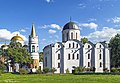 Transfiguration Cathedral and Boris and Gleb Cathedral in Chernihiv
 -
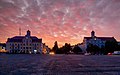 Krasna Square in Chernihiv
 -
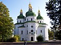 St. Nicholas Cathedral in Nizhyn
 -
 Transfiguration Monastery in Novhorod-Siverskyi
 -

-
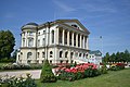
 Sokyryntsi Palace
 -
 Kyrylo Rozumovskyi's Palace in Baturyn
 -
-


See also
- Subdivisions of Ukraine
- Chernihiv Governorate
References
- )
- ^ Zelensky appoints head of Chernihiv Regional State Administration, Ukrinform (4 August 2021)
- ^ a b Чисельність наявного населення України на 1 січня 2022 [Number of Present Population of Ukraine, as of January 1, 2022] (PDF) (in Ukrainian and English). Kyiv: State Statistics Service of Ukraine. Archived (PDF) from the original on 4 July 2022.
- ^ "Валовии регіональнии продукт".
- ^ "Украинские пограничники сообщили об атаке границы со стороны России и Белоруссии". Interfax. 24 February 2022. Archived from the original on 24 February 2022. Retrieved 24 February 2022.
- ^ "Войска России на севере Украины продвинулись вглубь до пяти километров – Арестович". Archived from the original on 24 February 2022. Retrieved 24 February 2022.
- ^ "Перші три дні повномасштабної російсько-української війни (текстовий онлайн) | Громадське телебачення". Hromadske (in Ukrainian). 24 February 2022. Archived from the original on 24 February 2022. Retrieved 24 February 2022.
- ^ Russian Military Leaves Chernihiv Region, Plants Mines In Many Areas - Governor Chaus, Ukrainian News Agency (4 April 2022)
- Ukrayinska Pravda(5 April 2022)
- ^ "Чисельність наявного населення України (Actual population of Ukraine) Archived April 6, 2022, at the Wayback Machine" (PDF) (in Ukrainian). State Statistics Service of Ukraine. Retrieved 11 July 2021.
- Kardash, Peter. Ukraine and Ukrainians. Ed. Peter Lockwood. Melbourne: Fortuna Publishers, 1988.
- (1972) Історіа міст і сіл Української CCP - Чернігівська область (History of Towns and Villages of the Ukrainian SSR - Chernihiv Oblast), Kiev. (in Ukrainian)
- Information Card of the Region - Official site of the Cabinet of Ministers of Ukraine
- Богомолець. О. "Замок-музей Радомисль на Шляху Королів Via Regia". — Київ, 2013
External links
 Definitions from Wiktionary
 Media from Commons
 News from Wikinews
 Quotations from Wikiquote
 Texts from Wikisource
 Textbooks from Wikibooks
 Resources from Wikiversity
- Very detailed map of Chernigov Guberniya as in 1910 Archived 10 February 2012 at the Wayback Machine Latinised placenames
- Chernihiv Oblast State Administration (in Ukrainian)
- patent.net.ua - Symbols of Chernihiv Oblast
- The Official Site of the Radomysl Castle Archived 14 August 2020 at the Wayback Machine
- Economic Portal of Chernihiv Region
| International | |
|---|---|
| National | |
| Geographic | |