
Cutler Formation
| Cutler Formation | ||
|---|---|---|
Leonardian | ||
Approximate paleocoordinates 0°42′N 36°06′W / 0.7°N 36.1°W | | |
| Region | Colorado Plateau | |
| Country | United States | |
| Extent | Arizona Colorado New Mexico Utah | |
| Type section | ||
| Named for | Cutler Creek, north of Ouray, Co | |
| Named by | Cross & Howe | |
| Year defined | 1905 | |
 Cutler Formation (the United States)  Cutler Formation (Colorado) | ||
The Cutler Formation or Cutler Group is a
Description
At its type area north of
The formation overlies the
The formation has been dated to
The undifferentiated Cutler consists of
Subunits
The Cutler has been placed at either
- De Chelly Sandstone(Arizona, Colorado, New Mexico, Utah) — youngest
- White Rim Sandstone (Utah)
- Organ Rock Shale(Arizona, Colorado, New Mexico, Utah)
- Cedar Mesa Sandstone (Arizona, Utah)
- lower Cutler beds (Arizona, Colorado, New Mexico, Utah) — oldest
Beds formerly assigned to the
The stratigraphy of the lower Cutler beds has long been controversial.
In the Chama Basin of New Mexico, the Cutler Group has been divided into two formations:[20]
- Arroyo del Agua Formation — younger
- El Cobre Canyon Formation — older
A sandstone unit resembling the De Chelly Sandstone is present above the Arroyo del Agua Formation in the southernmost part of the basin, but in this region it is assigned to the Yeso Group.[20]
Extent
Cutler outcrops are found in these geologic locations in Arizona, Colorado, New Mexico and Utah.
- Black Mesa Basin[21]
- Paradox Basin[21]
- Piceance Basin[22]
- San Juan Mountains province[3]
- San Juan Basin[9]
- Uinta Basin[22]
History of investigation
There is no designated type locality for the Cutler. It was named by Charles Whitman Cross and Ernest Howe in 1905 after Cutler Creek, which enters Uncompahgre River about 4 miles north of Ouray, Colorado.[23] They found that nonfossiliferous red beds provisionally assigned to the Dolores Formation were separated from overlying fossiliferous Triassic beds by a significant angular unconformity. The lower beds were tentatively identified as Permian beds, and were removed from the Dolores Formation to the newly designated Cutler Formation.[3]
Baker and Reeside revised Cross and Howe's work in 1929, tracing the Cutler across the Colorado Plateau and dividing the formation into the Halgaito Tongue, Cedar Mesa Sandstone Member, Organ Rock Tongue, and White Rim Sandstone Member. They also confirmed Cross and Howe's dating of the formation to the Permian.[21] The Cutler was traced through the Jemez Mountains and found to be laterally equivalent to the Abo Formation by Wood and Northrop in 1946.[9]
In 1958, Wengerd and Matheny raised the formation to
-
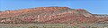 Cutler and Chinle formations in Lisbon Valley, San Juan County, Utah
 -
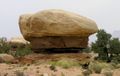 Cedar Mesa Sandstone overlaying Organ Rock Shale, Canyonlands, Utah

References
- U.S. Department of the Interior. Retrieved 30 September 2018.
- ^ "Stratigraphy of Canyon de Chelly National Monument". Geology of National Parks, 3D and Photographic Tours. United States Geological Survey. Archived from the original on 1 October 2018. Retrieved 30 September 2018.
- ^ hdl:1969.1/2953.
- ISBN 9781607810049.
- ^ .
- ^ a b c Fillmore 2010, p. 105.
- ^ doi:10.3133/pp1505A.
- .
- ^ Wikidata Q62639452.
- .
- ^ a b Fillmore 2010, p. 107.
- ^ Moore, K.D.; Soreghan, G.S.; Sweet, D.E. (2008). "Stratigraphic and Structural Relations in the Proximal Cutler Formation of the Paradox Basin: Implications for Timing of Movement on the Uncompahgre Front". The Mountain Geologist. 45 (2): 49–68. Retrieved 16 February 2022.
- ^ Fillmore 2010, pp. 108–109.
- ^ a b Fillmore 2010, pp. 115–117.
- ^ Loope, David B.; Sanderson, George A.; Verville, George J. (October 1990). "Abandonment of the name "Elephant Canyon Formation" in southeastern Utah: Physical and temporal implications". The Mountain Geologist. 27 (4): 119–130. Retrieved 27 July 2021.
- ^ doi:10.3133/b00P.
- doi:10.3133/ar21_2.
- doi:10.3133/b896.
- .
- ^ a b Lucas, Spencer G.; Krainer, Karl (2005). "Stratigraphy and correlation of the Permo-Carboniferous Cutler Group, Chama Basin, New Mexico" (PDF). New Mexico Geologic Society Field Conference Series. 56: 145–159. Retrieved 9 July 2020.
- ^ .
- ^ .
- ^ Keroher, Grace C., Lexicon of Geologic Names of the United States for 1936-1960, Part 1, p. 1019, at Google Books
- .