
Reipoltskirchen
Reipoltskirchen | |
|---|---|
 Coat of arms | |
Location of Reipoltskirchen within Kusel district  | |
 Reipoltskirchen  Reipoltskirchen | |
| Coordinates: 49°38′4.6″N 7°39′42.25″E / 49.634611°N 7.6617361°E | |
| Country | Germany |
| State | Rhineland-Palatinate |
| District | Kusel |
| Municipal assoc. | Lauterecken-Wolfstein |
| Government | |
| • Mayor (2019–24) | Ernst Eckert[1] |
| Area | |
| • Total | 7.49 km2 (2.89 sq mi) |
| Elevation | 208 m (682 ft) |
| Population (2022-12-31)[2] | |
| • Total | 353 |
| • Density | 47/km2 (120/sq mi) |
| Time zone | UTC+01:00 (CET) |
| • Summer (DST) | UTC+02:00 (CEST) |
| Postal codes | 67753 |
| Dialling codes | 06364 |
| Vehicle registration | KUS |
| Website | www.reipoltskirchen.de |
Lordship of Reipoltskirchen Herrschaft Reipoltskirchen | |||||||||
|---|---|---|---|---|---|---|---|---|---|
| before 1500–1792 | |||||||||
| Status | Saar) | 1792 | |||||||
| 1816 | |||||||||
| |||||||||
Reipoltskirchen is an
Geography
Location
Reipoltskirchen lies in the Odenbach valley in the north of the North Palatine Uplands at an elevation of some 200 m on a slight broadening of the valley floor. The mountains on either side of the valley climb rather steeply upwards, reaching more than 300 m above sea level on the right (east) bank and more than 400 m above sea level on the left (west) bank (Steinkopf 403.3 m, Platte 361 m, Galgenkopf 303 m). While the Ingweilerhof lies in the dale, along with the main centre, Ausbacherhof and Karlshof are to be found on the heights that stretch out between the Odenbach valley and Lauter valley to the west. The municipal area measures 652 ha, of which roughly 7 ha is settled and 250 ha is wooded.[3]
Neighbouring municipalities
Reipoltskirchen borders in the north on the municipality of Becherbach, in the northeast on the municipality of Nußbach, in the southeast on the municipality of Hefersweiler, in the south on the municipality of Relsberg, in the southwest on the municipality of Einöllen, in the west on the municipality of Hohenöllen and in the northwest on the municipality of Cronenberg.
Constituent communities
Reipoltskirchen's
Municipality’s layout
Reipoltskirchen's main centre stretches along the left bank of the stream on roads that climb up to the western heights. A few houses in the southeast of the village stand on the far bank and are linked with the village centre by the bridge carrying the
History
Antiquity
Reipoltskirchen was settled quite early on. The latest archaeological find was unearthed one kilometre south of Reipoltskirchen, an old Roman house, that is to say, a villa rustica, believed to have been built between about AD 100 and 200, with its associated stabling and lodging for servants. This villa may have arisen from a foregoing Celtic settlement. In the 6th and 7th centuries, at the time when the Franks, a Germanic tribe, were taking over the land, a Frankish settlement arose in the Odenbach valley roughly where the Nußbach (formerly the Hahnenbach) empties into the Odenbach. It was called Hundheim am Steg.[6]
Middle Ages
Sometime about 980, a Frank named Richbald built a church about a kilometre northwest of Hundheim am Steg. Over the years, a settlement grew up around it and took the name Richbaldeskirchen, after the man who had built the church. This earliest church is believed to have been wooden, but it was replaced by a sturdier building in the 10th or 11th century. This church had its first documentary mention in 1222 in Prüm Abbey’s book of souls as Kirche mit Leichenhof (“church with graveyard”). The people who settled there cleared land and farmed, although apparently the land did not yield up plentiful harvests.
It is likely that the region around Reipoltskirchen was originally free
Other than Meffridus de Ripoldeskirchen whose name cropped up in a document, no Lords of Reipoltskirchen are known to history. More is known about the families Bolanden and Hohenfels. Werner I of Bolanden, an Imperial ministerialis, founded the Hane Monastery near Bolanden in 1129. Werner II endowed the Rodenkirchen Monastery. Philipp III of Bolanden (d. 1220) had Castle Ehrenfels built on the Rhine. His son Philipp IV wed Elisabeth von Hohenfels, and thenceforth the House of Hohenfels was always seen as a branch of the House of Bolanden. One of Philipp's sons, Dylmann (Theoderich), was Imperial Treasurer and called himself Dylman von Hohenfels. His own son, Heinrich, in turn is held to be the founder of the Reipoltskirchen line. He bore the double title Heinrich von Hohenfels und Herr zu Reipoltskirchen (Heinrich of Hohenfels and Lord at Reipoltskirchen), and he was also known for participating in Emperor Henry VII's journey to Rome.
According to Father Michael Frey's (1788–1854) Beschreibung des Rheinkreises (“Description of the Rheinkreis”, that is, the Palatinate during the time after the Congress of Vienna when it was Bavarian), it was sometime about 1181 that the lowland castle was built. This castle belonged as a fief from Prüm Abbey in the Eifel to the Lords of Bolanden. Known to have been among the earliest Burgmannen are Meffried von Reipoltskirchen (about 1196) and Jakob Boos zu Reipoltskirchen (1209). The castle eventually passed by inheritance to the Lords of Hohenfels, had its first documentary mention in 1276 and beginning in 1297, it became the seat of the lordly sideline founded by Heinrich von Hohenfels, Lord of Reipoltskirchen.
Sometime between 1194 and 1198, or perhaps even as early as 1189/1190, Reipoltskirchen had its first documentary mention in a directory of landholds kept by Count Werner von Bolant, whose family seat – a castle – stood in Bolanden on the
The first “Knight of Reipoltskirchen” to appear in the historical record is Heinrich von Hohenfels und Reipoltskirchen, who was mentioned in 1297, and who died in 1329 and was buried at the Zion Monastery Church (Klosterkirche Sion) in
Modern times
Among Wolfgang's (d. 1538) and Katharina von Rappoltstein's issue was Johannes (or Johann) II, who as a young knight led
In 1548, the
Between 1560 and 1570, the
Sydonia's younger son Steino bequeathed his half by way of his daughter Elisabeth Amalie to the Lordship of
In 1618, the Thirty Years' War broke out; by the time it was over in 1648, the whole land had been laid waste, and there were almost no inhabitants left in it. In 1628, both through a failure of the House of Manderscheid to produce a male heir and by marriage, Reipoltskirchen became subject to an administrative arrangement called an Erbgemeinschaft or a Ganerbschaft. This meant that the Lords of Manderscheid-Keil and the Counts of Löwenhaupt-Rasburg each held a share in the lordship and ruled the estate jointly as a kind of joint inheritance. In the midst of the Thirty Years' War, on Michaelmas (29 September) 1631, Johann Heinrich Roos, later to be a prominent painter, was christened in Reipoltskirchen. However, as to whether he was actually born there, this is unclear (his birthplace is usually given as Otterberg). Nonetheless, his marriage certificate, made out in Sankt Goar in 1656, states that he was von Reuppelskirchen in der Pfalz bürttig (born in Reuppelskirchen in the Palatinate).
In 1670, there was a dispute with Electoral Mainz over feudal rights in the Rhenish-Hessian villages of Marienborn (today an outlying centre of Mainz), Mommenheim and Lörzweiler, which belonged to Reipoltskirchen.
From 1681 to 1697, Reipoltskirchen belonged to the French Saar Province. In 1683, the Duchy of Palatinate-Zweibrücken passed by way of inheritance to the royal house of Sweden, and when French rule ended in Reipoltskirchen, it found itself under Swedish administration until 1718.
In 1720, there was a
In 1722, the Imperial Count of Hillesheim bought a one-fourth share of the lordship over Reipoltskirchen from the Counts of Löwenhaupt. This deed was overturned by the Reichskammergericht, although the actual reversal of the deed did not take place until 1754. The Count of Hillesheim, though, evidently did not give up his ambition to have a share of the Reipoltskirchen lordship, for in 1730, he bought a one-half share of the lordship from the holdings of the Counts of Manderscheid. The Hillesheims held this share until the French Revolution. The ecclesiastical arrangements were altered by the Count of Hillesheim. A Catholic parish was established in Reipoltskirchen, and made subject to the Archbishopric of Mainz. Protestant-Lutheran parishes were set up in Finkenbach, Rathskirchen and Rudolphskirchen (today an outlying centre of Rathskirchen). On 11 October 1748, Count Willhelm von Hillesheim died in Reipoltskirchen. After his death, an extensive overhaul of the lordship arrangements was negotiated between Löwenhaupt and Hillesheim. This agreement was approved by the Emperor on 21 March 1754. In 1761, there arose disputes with the Duchy of Palatinate-Zweibrücken over tithes, compulsory labour, taxes and Wildfangrecht (a system under which a feudal lord could incorporate any “stray” person in his domain into the ranks of his subjects if he or she could not demonstrate allegiance to another lord). Although the Reichskammergericht in Wetzlar ruled in Reipoltskirchen's favour in the case of its grievance, the great Duchy kept on doing with the dwarf state of Reipoltskirchen whatever it deemed fit. On 28 November 1763, the Löwenhaupts sold their share in Reipoltskirchen to Imperial Count Philipp Andreas Ellrodt (or Andreas Philipp von Ellrath, later Ellroth, b. 1707; d. 1 January 1767), a high official in Bayreuth (where Count Nils was likewise in state service), for 140,000 Gulden. Kasimir received 60,000 Gulden of this total while his brother Nils drew a yearly income of 3,000 Gulden from the other 80,000 Gulden. The deed was even prefaced with an exact description of the Lordship of Reipoltskirchen, which said in part: Die Reichsherrschaft Reipoltskirchen steht mit dem hochgräflichen Haus von Hillesheim in gleicher Gemeinschaft, liegt zwischen den hochfürstlich - zweibrückischen und kurfürstlich - pfälzischen Ländern und hat ihr eigenes, meistensteils in einem Reich fortgehendes Territorium. (“The Imperial Lordship of Reipoltskirchen stands with the high comital House of Hillesheim in the same community, lies between the high princely land of Zweibrücken and the Electoral-Palatine land and has its own, mostly continuous territory.”). At the same time, Nils von Löwenhaupt's daughter, Wilhelmine, wed the buyer Andreas Philipp von Ellrath's son, who was also a state minister in Bayreuth, but he died not long afterwards, in 1765. Wilhelmine then married a Dr. Johannes Nikolaus von Mader, thereby losing her ownership rights to Reipoltskirchen. By that time, though, the elder Ellrath had run into financial trouble anyway, and in 1770, he sold his share in the Lordship of Reipoltskirchen for 76,000 Gulden to the County Palatine of Zweibrücken, then ruled by Duke Christian IV. This sale was, however, overturned by a ruling at the Hofgericht – a high lordly court – in Vienna after the Countess of Hillesheim (d. 1773) raised objections. So, Ellrath got this share back after the Countess's death, in 1776, prompting him to put it straight back on the market and seek a new buyer.
A state official named Baron Ludwig von Esebeck (lord of the Ingweiler castle estate), working as an agent representing another, made himself known, and through him, the Löwenhaupt share of Reipoltskirchen passed in 1777 to a countess named Karoline von
Belonging to the lordship towards the end of its existence were the following villages: Reipoltskirchen, Nußbach, Rathskirchen, Reichsthal, Hefersweiler, Relsberg and Morbach, along with a half share of an enclosed area at Rudolphskirchen and the scattered holdings of Finkenbach-Gersweiler, Schönborn and Dörnbach. All these villages jointly belonged to the owners of Hillesheim and the Countess of Isenburg. Belonging to the Countess of Isenburg alone were the bought villages of Seelen, Berzweiler, Niederkirchen and the other half share of Rudolphskirchen.[9]
Recent times
French Revolutionary troops spared Reipoltskirchen and its castle any destruction. On 3 March 1793, they marched into the village. On 6 March, they planted a Freedom Tree in the village, and then made the villagers pay contributions when this symbol of the French Revolution was damaged. On 24 April, the Isenburg Amtmann, Wilhelm Stern, reported to the Princely Estate Administration in Mannheim that the French had forced the subjects to take a vow to freedom and equality. In 1797, with the beginning of French administration, the Glan became a border river and Reipoltskirchen found itself in the Department of Mont-Tonnerre (or Donnersberg in German), the Arrondissement of Kaiserslautern, the Canton of Lauterecken and the Mairie (“Mayoralty”) of Odenbach. The first French commissioner general, a man from Alsace named Rudler, took office on 4 September. In 1798, he promulgated a law abolishing feudalism, along with all the payments, compulsory labour and tithes that hitherto had been every subject's burden, owed to the lord and the church in the Palatinate. The first Adjunct responsible for Reipoltskirchen was Michael Konrad from Nußbach. As of 26 May 1798, the terms of the Directorial constitution that applied in France were introduced. On 16 June 1799 (27 Prairial in the year VI of the Revolution), all lordly and ecclesiastical holdings were declared national property of the new state, and all the old feudal lordships were dissolved. This meant the end for the Lordship of Reipoltskirchen, too. Now that the castle stood empty, poor people sought shelter there. Others used it as a stone quarry. Auctions were held on 20 March 1805, 30 November and 29 December 1808 and 29 April 1813 to sell these formerly lordly properties off. In 1805, a few buildings formerly held by the house of Isenburg passed to Falciola from Lauterecken. In 1808, the Amtshaus with its tower and some outbuildings went to Charles Baumann from Lauterecken, Henry Puricelli from Meisenheim, and Jean de Hoeffersweiler and Michael Seligmann from Kreuznach. The last Isenburg holding came under the hammer in 1813 and went to Bernhard Jacob Reinach from Mainz. By and by, the buyers then sold the properties that they had acquired to various interested parties, earning a healthy profit. The Treaty of Lunéville was signed on 9 February 1801, under whose terms all lands on the Rhine’s left bank had to be ceded to France. At about this time, Reipoltskirchen had 220 inhabitants.
There was a small Jewish community in the village in 1808, consisting of ten families and all together 56 persons. It likely formed in the 18th century under the comparatively liberal residency requirements that were then customary in smaller lordships. Particularly worthy of mention is the family Grünebaum, from whose midst arose the scholar Dr. Elias Grünebaum, who for many years was the Regional Palatine Rabbi (1836-1893). in 1809, Reipoltskirchen passed to the Mairie of Becherbach.
After

About 1830, the painter Peter Gayer completed a sepia drawing of the castle ruin, the earliest picture known of the complex, which now gives the modern viewer an idea of the condition in which the old moated castle found itself at that time: the two-floor Amtshaus has already collapsed in part; of the main gate with its drawbridge nothing is left. In the original cadastral survey of Reipoltskirchen in 1845, the castle is described as being under private ownership: Der ehemalige Schlossturm, bestehend in einem Wohnzimmer, Keller, Stall und Hofraum (“The former castle tower, consisting of a livingroom, cellar, stable and courtyard”).
A schoolhouse was built up from the church in 1836. The church itself was torn down owing to its state of disrepair and replaced with a new one in 1847 and 1848. Given the dearth of funds for the project, the parishioners had to forgo a tower and a sacristy. The new church was consecrated on 8 August 1849. In 1858, the church was furnished with an organ. It turned out by 1876, though, that the building work done on the church had been somewhat less than flawless, and it was already falling into such disrepair that it had to be closed. On 11 July 1878, the foundation stone for the church that still stands today was laid. Consecration came on 17 June 1880. At the same time, the old rectory was replaced with the one that still stands today.
In 1883, the
The 1836 school building, which also housed the teachers’ dwellings, had become antiquated and too small by 1907, and so it was decided that a new school building was needed. The old schoolrooms were converted to dwelling space and the new school building was built on a plot of municipal land called “Hirtengarten” in 1908. It was a school building that was typical for its time, built of sandstone with four floors. The ground floor was to house the Protestant school while a small sideroom was to house the mayor's office. On the next floor up were not only the Catholic school but also a storage and archive room for the municipal office. On the top floor, a bell frame with a small bell and a tower was installed. The Protestants were allowed to use the bell in their worship, and the upper school room was also made available to them for church services.
The 1920s were a bad time for all Germany. For instance, the rampant inflation that characterized Weimar Germany at this time led to a six-pound (3 kg) loaf of bread costing more than 18,000,000,000 marks. On 6 November 1923, a 30-man force of separatists favouring the annexation of the Palatinate to France invaded Reipoltskirchen. In 1924, Reipoltskirchen was connected to the electrical grid of Pfalzwerke AG. A watermain followed on 14 October 1928. On 4 February 1927, the Ministry of State for the Interior in Munich gave its approval for the municipality of Reipoltskirchen to bear the arms once borne by the lordship of Hohenfels-Reipoltskirchen (see Coat of arms below).
On 19 March 1945, United States troops marched into Reipoltskirchen; a local mill owner was installed as mayor. Alois Moog was elected mayor in the first mayoral election after the Second World War on 15 September 1946. That same year, Reipoltskirchen became part of the then newly founded state of Rhineland-Palatinate. Despite it being the Americans who had marched into the village, Reipoltskirchen soon afterwards found itself in the French zone of occupation, and until 1955, it was subject to the Gouvernement Militaire Français in the wake of the unconditional surrender by the Third Reich.
In the course of the 1968 administrative restructuring in Rhineland-Palatinate, Reipoltskirchen was grouped into the Verbandsgemeinde of Wolfstein in 1971 as an
In 1982 and 1983, the castle complex was taken over by the district and placed under monumental protection. At the same time, the Weber Franz and Süß Franz houses were acquired. The Klein-Weißmann house was bought from the district in 1988. Until then, the district had invested a great deal and acquired several private houses in the castle area. In 1983, the former schoolhouse, too, was placed under monumental protection.
In 1986 the
Population development
While in earlier times the greater part of Reipoltskirchen's population earned their livelihoods at agriculture, shifts in economic structure, particularly after the Second World War, have led to only one in five villagers still working the land. The greater part of the workforce must now commute to work, mainly to Kaiserslautern, Wolfstein and Lauterecken. However, even earlier than the war, there had been job opportunities in fields other than farming, such as craft occupations, work in stone quarries and mines and in the service of the resident lordship. Apparently, many Jews were employed in the feudal administration, for at the time when the lordly houses were auctioned off in the time of the French First Republic, they were occupied to a great extent by Jewish inhabitants. Although 19 Jews were registered in Reipoltskirchen in 1825, only a few years earlier, there may have been more than twice as many living in the village. Today, Jews no longer live in Reipoltskirchen. The shares of the population held by Catholics and Protestants are 55% and 40% respectively.
The following table shows population development over the centuries for Reipoltskirchen, with some figures broken down by religious denomination:[15]
| Year | 1802 | 1825 | 1835 | 1871 | 1905 | 1939 | 1961 | 1998 | 2008 |
| Total | 284 | 342 | 430 | 469 | 406 | 436 | 489 | 409 | 384 |
Catholic |
198 | 274 | |||||||
Evangelical |
119 | 215 | |||||||
| Jewish | 18 | – |
Municipality’s name
At its appearance in the village's first documentary mention in the Bolant directory of fiefs towards the end of the 12th century, the name took the form Ripoldeskirchen, one that with only slight changes (Ripolteskirchen, Ripoldiskirchen) persisted until the mid 14th century. Then, the elision of the unstressed E in Ripoldes— began appearing in records as the predominant form, although it had been cropping up here and there since the mid 13th century. Thus, beginning about 1350, the forms Ripoltzkirchen and Rypolßkirchen were predominant. More significant, though, was the shift from the long I in the first (stressed) syllable (IPA: [iː] – pronounced like the “ee” in “cheese”) to a diphthong (IPA: [aɪ] – closer to the “i” in “wine”). This was part of a sound-shift process that affected the German language as a whole, spreading from the east towards the end of the 15th century and gradually making its way across the Rhine into the Palatinate. Since 1497, the village's name has taken its current spoken form (namely IPA: [ˈʁaɪpɔltskɪʁçən]), although there have been variant spellings.
There is no great puzzle as to the name's meaning. The ending —kirchen obviously comes from the root of the German word Kirche (“church”;
The municipality's name thus means nothing less than “At Reipolt’s Church”, Reipolt (Richbald) being the founder of this church (or perhaps the original owner). What is missing, though, is any great deal of information about this Richbald. More knowledge might lead to a better reckoning of Reipoltskirchen's actual time of founding. Beyond archaeology, only research into placenames could help with that. In Germany, the form of a placename is often a clue to how old the name is. What is known, for instance, is that the Odenbach valley was still being settled in the time after the Migration Period, between about 600 and 750. This can be deduced from the great number of places in the area with names ending in —weiler, a characteristic placename ending of that time, originally used to designate a single homestead (as a standalone word, it now means “hamlet” in German). Local examples are Ginsweiler, Ingweiler, Berzweiler and Hefersweiler, and the ending would indicate that they must be older than Reipoltskirchen (although admittedly they are mentioned only later in the written record).[16]
In the late 12th century, the name Meffridus de Ripoldeskirchen cropped up in a document. Other forms of the village's name that have appeared in documents over time are Ripoldeskirchen (1200), Ribolskirchin (1259), Ripoldiskirchen (1297), Ropelskirchen and Ripoltzkirchen (late 14th century). The current form of the name is known to have appeared as early as 1824.
Ausbach was called Ußbruck in 1437 (according to Goswin Widder) and in 1446 Ußbach. The ending —bruck in the 1437 name form might mean that there was a bridge (German: Brücke) crossing the Ausbach here at the time. The current name Ausbacher Hof first appears in the late 16th century in the phrase im Auspacher Hoffe. According to researchers Dolch and Greule, this was a settlement on a brook (German: Bach) founded by a man named Udsa. Ingweiler had its first documentary mention in 1339 as Ingemudewilre. Other forms of the centre's name that have appeared in documents over time are Engelmorsweiler (no year), Wingewilr (1376), Ingwilre (1426), Ingwyler (1514), Schloss Ingweiler (1761) and Ingweilerhof (1824). Dolch and Greule believe that this centre may have been named after a woman named Engilmuot.[17]
Vanished villages
To Reipoltskirchen's southeast once lay an estate named Hundheim (or Hundheim am Steg), not to be confused with the still existent
Religion
Reipoltskirchen originally belonged to the Glan
Politics
Municipal council
The council is made up of 8 council members, who were elected by
Mayor
Reipoltskirchen's mayor is Ernst Eckert.[1]
Coat of arms
The German blazon reads: Im geteilten Wappenschild oben ein silbernes Rad auf blauem Grund und unten ein gestürzter silberner Anker, begleitet von zehn silbernen Schindeln auf grünem Grund.
The municipality's arms might in English heraldic language be described thus: Per fess azure a wheel spoked of six argent and vert semé of ten billets an anchor reversed, all of the second.
The two charges, the wheel and the anchor, are drawn from arms once borne by the local lords, the Falkensteins and the Hohenfelses
The Lords of Bolanden stood as Imperial ministeriales in the service of the ecclesiastical Electorate of Mainz, whose coat of arms bore a silver wheel on a red field. As Mainz vassals, they used the same arms, but in different tinctures, with a red wheel on a gold field. Their successors, the Falkensteins and the Hohenfelses, originally bore the Bolanden wheel in their arms, but in different tinctures once again, namely a silver wheel on a blue field. Later the Hohenfelses bore gold cloverleaves. The newer line of Hohenfels-Reipoltskirchen also bore a silver wheel on the helm. Only after the older Hohenfels line died out in 1415 did the local lords adopt the arms that they had borne until now as the noble family's arms, which since 1290 had borne, instead of the wheel, an anchor “reversed” (that is, upside down to the way it usually appears in heraldry) on a green field scattered with gold “billets”. Until the Hohenfels-Reipoltskirchens died out in 1602, the arms were quarterly with the silver wheel on blue in the first and fourth fields and the silver anchor with the ten billets on green in the second and third fields.
The arms have been borne since 4 February 1927 when they were approved by the Bavarian Ministry of State for the Interior in Munich.[21]
Culture and sightseeing
Buildings
The following are listed buildings or sites in Rhineland-Palatinate's Directory of Cultural Monuments:[22]


- Castle, Mühlstraße/Kegelbahnstraße (monumental zone) – former lowland castle of the Lords of Bolanden, possibly founded in 1181, first mentioned in 1276; Romanesque keep, upper floor about 1500, ringwall mainly modern renovations, vaulted cellar at Amtshaus, 16th century, well; four architectural fragments in the retaining wall, in the east a wall and a moat; one of the Palatinate's best preserved lowland castles
- Catholic church, Hauptstraße 11 – sandstone-block building, Rundbogenstil, 1879/1880; sandstone epitaph, early 17th century; in the churchyard a Crucifix, cast-iron corpus 19th century (see also below)
- Hauptstraße 8 – former Alte Schule (“Old School”), plastered building, Rundbogenstil, 1838, architect possibly Johann Schmeisser, Kusel; characterizes village's appearance
- Hauptstraße 10 – rectory, one-floor plastered building with knee wall, 1885, architect Spithaler; whole complex of buildings with church and Old Schoolhouse
- Hirtenstraße 12/13 – former Neue Schule (“New School”), plain stone-block building, 1907, architect Regional Master Builder Kleinhans
- On Landesstraße 382 not far from the north entrance to the village – hourstone; sandstone pillar, 19th century
- Ingweilerhof, Ingweilerhof 2 – four-sided complex; Baroque building with hipped roof, marked 1730, with older part; in the chapel two tomb slabs, 17th and 18th centuries
- Villa rustica, southeast of the village near the Ingweilerhof – wall traces of a small Roman country estate, 1st to 3rd century
More about buildings
Reipoltskirchen's first church, which was endowed by the village's namesake, Richbald, was followed by three others, each built on the same spot. The one that stands now is the parish church consecrated in 1880 as the Church of Saint John of Nepomuk (St. Johannes Nepomuk), whose 35 m-tall tower has become one of the municipality's landmarks.
Below the castle are three complexes from the project Kunst im Grünen (“Art in the Green”). The “landscape pictures” – actually works of art created out of landscapes – covering current themes can be viewed especially well from the castle tower.[23]
Regular events
Reipoltskirchen holds its
Clubs
Any further cultural life in Reipoltskirchen is characterized by the village's lively club life. There are a
Public institutions
The Catholic church maintains a parish library.[26]
Economy and infrastructure
Economic structure
While in earlier times agriculture was the mainstay of Reipoltskirchen's economy, only about 20% of the villagers still earn their livelihoods at farming now. There had been job opportunities in other fields, such as
Education
It is certain that the holders of the Lordship of Reipoltskirchen, too, put forth efforts to establish schooling. Nevertheless, no records about schools in Reipoltskirchen before 1800 are available. According to data from the registration of Jewish inhabitants in 1898, the village then had a Jewish schoolteacher. Later, standing side by side were a Catholic school and an
Transport
Serving nearby
Famous people
Sons and daughters of the town
- Elias Grünebaum (1807–1893)
- A rabbi and Jewish theologist, Grünebaum studied in Bonn and Munich and was a pupil of the philosopher Schelling. He compiled many books and other written works, and is held to be a liberal reformer of German Jewry. For more than 50 years, he headed the Rabbinical Region of Landau.[29]
- Jakob Grünebaum
- Elias’s uncle, likely born in Reipoltskirchen, Grünebaum emigrated sometime about 1850 to the United States. His sons founded banks and businesses in Chicago that still exist today under the name Greenebaum.[30]
- Emil Heuser (1851–1928)
- An historical researcher and First World War and was accorded high distinction. Retired as of 1920, he worked as curator of the Historical Museum of the Palatinate (Historisches Museum der Pfalz) and publisher of the magazine Historisches Museum der Pfalz. He also published many articles, mainly about Palatine history.[31]
- An historical researcher and
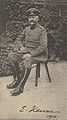
- Johann Heinrich Roos (1631–1685)
- Possibly born in Reipoltskirchen (at least according to his marriage certificate), as a master painter’s son, Roos later became a famous painter of animal subjects. After the Thirty Years' War, he stayed in Holland, where he became pupil of several well known painters. In 1664, he became court painter in Heidelberg, and in 1667 he went to Frankfurt. There, he died in an accident.[32]
-
 Johann Heinrich Roos
 -
 Emil Heuser in 1916


Pictures
-
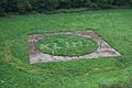 Kunst im Grünen - World Climate Conference in the “Old World”
 -
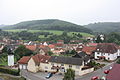 View from the castle towards the southwest
 -
 View from the castle towards the Kerweplatz (south)
 -
 The village square with thefire brigadeand the youth centre (Kellergeister)
 -
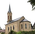 Side view of the parish church
.jpg)


Further reading
- Alexander Thon (editor): Wie Schwalbennester an den Felsen geklebt. Burgen in der Nordpfalz. 1st ed. Schnell + Steiner, Regensburg 2005, S. 126–129, ISBN 3-7954-1674-4.
References
- ^ a b Direktwahlen 2019, Landkreis Kusel, Landeswahlleiter Rheinland-Pfalz, accessed 2 August 2021.
- Statistisches Landesamt Rheinland-Pfalz. 2023.
- ^ Location
- ^ Constituent communities
- ^ Municipality’s layout
- ^ Antiquity
- ^ Middle Ages
- ^ Middle Ages
- ^ Modern times
- ^ Reipoltskirchen’s history
- ^ Reipoltskirchen’s history
- ^ Reipoltskirchen’s history
- ^ Reipoltskirchen’s history
- ^ Recent times
- ^ Reipoltskirchen’s population development
- ^ Municipality’s name
- ^ Municipality’s name
- ^ Vanished villages
- ^ Religion
- ^ Kommunalwahl Rheinland-Pfalz 2009, Gemeinderat
- ^ Description and explanation of Reipoltskirchen’s arms
- ^ Directory of Cultural Monuments in Kusel district
- ^ Kunst im Grünen
- ^ Regular events
- ^ Clubs
- ^ Public institutions
- ^ Economic structure
- ^ Education
- ^ Elias Grünebaum
- ^ Jakob Grünebaum
- ^ Emil Heuser
- ^ Johann Heinrich Roos
External links
- Municipality's official webpage (in German)
 | |||||
| Secular | |||||
| Counts / Lords |
| ||||
| Cities |
| ||||
1 Part of the Reichstag seat. 4 until 1736. 5 Joined Swiss Confederacy in 1515. Circles est. 1500: Bavarian, Swabian, Upper Rhenish, Lower Rhenish–Westphalian, Franconian, (Lower) Saxon Circles est. 1512: Austrian, Burgundian, Upper Saxon, Electoral Rhenish · Unencircled territories | |||||

| International | |
|---|---|
| National | |