
Dąbrówka Mała
Dąbrówka Mała | |
|---|---|
 | |
|
UTC+2 (CEST) | |
| Area code | (+48) 032 |
| Vehicle registration | SK |
| Primary airport | Katowice Airport |
Dąbrówka Mała (German: Kleindombrowka, Eichenau) is a district of Katowice. It has an area of 3.68 km2 and in 2007 had 5,411 inhabitants.[1]
During the German occupation (World War II), on April 3–4, 1940, the German police committed a massacre of 40 Poles from Katowice in Dąbrówka Mała (see Nazi crimes against the Polish nation).[2] The occupiers also operated a Polenlager forced labour camp for Poles in Dąbrówka Mała.[3]
Sights
Landmarks of Dąbrówka Mała include the Saint Anthony church and the former Dąbrówka Mała Gmina Office (now a healthcare center). There are two parks in the district: Park w Dąbrówce and Park Zielony Zakątek. At Plac Żołnierzy Września, the district's main square, there is a monument dedicated to Poles massacred by the Germans in Dąbrówka Mała on April 3–4, 1940.
Gallery
-
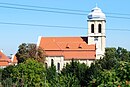 Saint Anthony church
 -
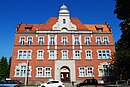 Former gmina office
 -
 Monument to Poles massacred in 1940
 -
 Old tenement houses
 -
 Park Zielony Zakątek


.jpg)


References
- ^ Urząd Miasta Katowice. "Katowice - Studium uwarunkowań i kierunków zagospodarowania przestrzennego" (PDF) (in Polish). Archived from the original (PDF) on 2011-11-04. Retrieved 2011-06-16.
- ^ Wardzyńska, Maria (2009). Był rok 1939. Operacja niemieckiej policji bezpieczeństwa w Polsce. Intelligenzaktion (in Polish). Warszawa: IPN. p. 142.
- ^ "Polenlager Kattowitz-Eichenau". Bundesarchiv.de (in German). Retrieved 5 June 2021.
| I. Central District |
| |
|---|---|---|
| II. Northern District |
| |
| III. Western District | ||
| IV. Eastern District |
| |
| V. Southern District |
| |
This Silesian Voivodeship location article is a stub. You can help Wikipedia by expanding it. |