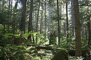
Forests of the United States

| This article is part of a series on the |
| Economy of the United States |
|---|
 |
It has been estimated that before European settlement, forests in the United States mainland covered nearly 1 billion acres (4,000,000 km2).[1] Since the mid-1600s, about 300 million acres (1,200,000 km2) of forest have been cleared, primarily for agriculture during the 19th century. [1]
As of 2016, roughly 36.21% (about one-third of the U.S.) is forested.
Current coverage
While total forest area has been relatively stable for the last 100 years, there have been significant regional shifts in the area and composition of the nation's forests. Reversion of marginal farmland in the east, large scale planting in the South, and fire suppression have contributed to increases in forest area. Urbanization, conversion to agriculture, reservoir construction, and natural disasters have been major factors contributing to loss of forests. [1]
Eastern forests cover about 384 million acres (1,550,000 km2) and are predominantly
Major uses of forests include
There are
The most heavily-forested regions of the U.S. are Maine, New Hampshire, American Samoa, the Northern Mariana Islands and West Virginia; the least heavily forested regions are North Dakota, Nebraska, and South Dakota.[2]
The U.S. had a 2018 Forest Landscape Integrity Index mean score of 6.65/10, ranking it 67th globally out of 172 countries.[6]
Environmental issues
Deforestation
In the United States, deforestation was an ongoing process until recently. Between 2010 and 2020, the US forests increased 0.03% annually, according to FAO (Food and Agriculture Organization of the United Nations).[a]
Native Americans cleared millions of acres of forest for many reasons, including hunting, farming, berry production, and building materials.
Invasive species
This section needs expansion. You can help by adding to it. (January 2019) |
Projects have been undertaken to remove
Wildfire
The five federal regulatory agencies managing forest fire response and planning for 676 million acres in the United States are the Bureau of Land Management, the Bureau of Indian Affairs, the National Park Service, the United States Forest Service and the United States Fish and Wildlife Service. Several hundred million U.S. acres of wildfire management are also conducted by state, county, and local fire management organizations. In 2014, legislators proposed The Wildfire Disaster Funding Act to provide $2.7 billion fund appropriated by congress for the USDA and Department of Interior to use in fire suppression. The bill is a reaction to United States Forest Service and Department of Interior costs of Western Wildfire suppression appending that amounted to $3.5 billion in 2013. [14]
Protected areas
National forests


See also
- Assisted migration of forests in North America
- François André Michaux, a botanist noted for his work on the trees found in America
- Hawaiian tropical rainforests
- List of U.S. National Forests
- National Park Service
- Senate Committee on Forest Reservations and the Protection of Game
- United States Forest Service
- Forests of Mexico
- Forests of Canada
Notes
References
- ^ nationalatlas.gov. May 7, 2009.
- ^ a b c https://www.fs.fed.us/sites/default/files/fs_media/fs_document/publication-15817-usda-forest-service-fia-annual-report-508.pdf
USDA - Forest Inventory And Analysis Fiscal Year 2016 Business Report. Page 71-72 (Page 79-80 of PDF). Table B-11. Land and forest area and FIA annualized implementation status by State and region, FY 2016. Data for territories: Table B-10. Status of FIA special project areas excluded from annualized inventory. Retrieved January 8, 2019. - ^ "Global Forest Resources Assessment 2005". UN Food and Agriculture Organization. 2005.
- ^ https://www.borealbirds.org/boreal-forest Boreal Songbird Initiative. Boreal Forest. Retrieved January 8, 2019.
- ^ https://www.princeton.edu/~ota/disk3/1984/8426/842609.PDF Princeton.edu. Chapter 6 - U.S. Tropical Forests: Caribbean and Western Pacific. Retrieved January 8, 2019.
- PMID 33293507.
- ^ "American Prehistory: 8000 Years of Forest Management". Forest History Society. Retrieved 8 June 2022.
- ^ "Major Trends, Forest Inventory & Analysis, 2002" (PDF). United States Forest Service. Retrieved 2016-09-24.
- ^ a b c Forest Resources of the United States Archived May 7, 2009, at the Wayback Machine
- ^ "Forest Facts, 2012" (PDF). United States Forest Service. 2014-08-31. Archived from the original (PDF) on 2021-04-28. Retrieved 2016-09-30.
- ^ "National Report on Sustainable Forests — 2010". United States Forest Service. 2014-04-29. Retrieved 2016-09-24.
- ISSN 0362-4331. Retrieved 2020-05-06.
- ^ https://phys.org/news/2018-07-percent-native-trees-rat-free-palmyra.html
Study shows 5,000 percent increase in native trees on rat-free Palmyra Atoll. July 17, 2018. Retrieved January 8, 2019. - ^ "Standards". www.nifc.gov. Retrieved 2023-05-18.
- ^ "History & Culture | US Forest Service". www.fs.usda.gov. 29 July 2016. Archived from the original on 2020-10-16. Retrieved 2020-10-16.
- FAO (2020). "Global Forest Resources Assessment" (PDF).


