
Great Lakes Circle Tour
Great Lakes Circle Tour | |
|---|---|
| Route information | |
| Existed | 1988–present |
| Location | |
| Country | United States |
| Highway system | |
| |
| |
| |
| |

The Great Lakes Circle Tour is a designated scenic road system connecting all of the
Tours

Lake Superior Circle Tour
Lake Superior Circle Tour | |
|---|---|
| Location | Around Lake Superior |
| Length | 1,280.56 mi (2,060.86 km) |
| Existed | 1988–present |
The Lake Superior Circle Tour (LSCT) follows state and provincial highways that are nearby the lake to loop around the entirety of Lake Superior. The LSCT follows state highways in the US states of Michigan, Wisconsin, and Minnesota, and provincial highways in the Canadian province of Ontario.
Michigan
In Michigan, the tour runs from the state line at Ironwood to Sault Ste. Marie. In between it follows U.S. Highway 2 (US 2) to Wakefield, M-28 to Bergland and M-64 to Ontonagon. At Ontonagon, the LSCT continues east along M-38 to M-26. It follows M-26 to Houghton and then follows US 41 north to Copper Harbor. There is a loop route along M-203 between Hancock and Calumet. Travelers following the tour need to backtrack down US 41 to Houghton and then follow US 41 back to M-28 in Covington. US 41/M-28 carries the tour to Harvey where M-28 carries it eastward. There is a spur routing along M-77 running north from Seney to Grand Marais. The mainline tour departs from M-28 to loop northward along M-123 through Newberry to Paradise and back to M-28. Then it follows M-28 for a third time until reaching Interstate 75 (I-75) where it follows the freeway north to Sault Ste. Marie. It leaves Michigan on the Sault Ste. Marie International Bridge crossing into Ontario.[2]
Ontario
Once in Ontario, the tour follows city streets through
Minnesota
The LSCT follows Minnesota State Highway 61 (MN 61) between the Canada–United States border (near Thunder Bay) and the city of Duluth. In Duluth, the tour route follows I-35 southbound to the US 2 exit to Wisconsin.[4]
Wisconsin

The circle tour crosses into Wisconsin on the
Lake Michigan Circle Tour
Lake Michigan Circle Tour | |
|---|---|
| Location | Lake Michigan |
| Existed | 1988–present |
The Lake Michigan Circle Tour (LMCT) loops around
.Illinois
The LMCT follows Illinois Route 137 from the Wisconsin state line south on Sheridan Road and joins Lake Shore Drive (U.S. 41). The route then follows U.S. 41 as U.S. Routes 12 and 20 run concurrent but split quickly. The tour then follows U.S. Route 12 into Indiana.
Indiana
The LMCT follows I-94 and US 12 in Indiana.[5] The Indiana portion of the Lake Michigan Circle Tour is the urban stretch of the lake. It begins on the Illinois line in the City of
Starting from Chicago, US 12 enters
US 12 turns more southerly as it passes west and south of Indiana Harbor, an industrial complex of mills, refineries, and docks. Entering East Chicago, US 12 turns east onto Columbus Drive, heading through the Indiana Harbor neighborhood of East Chicago. From East Chicago US 12 becomes Industrial Drive in Gary.[7]
The alternate route for the Circle Tour is along I-94, which is joined with I-80 as the
Gary is on both routes of the Circle Tour. I-80/I-94 and US 12 both enter the city. US 12 is closer to the lake, entering from East Chicago on Industrial Drive. Named appropriately for the industries and the Gary Airport that developed along the lakefront. U.S. Steel's Gary Plant began in 1906, and brought major industries to this area. Located on the southern shore of Lake Michigan, the city offered direct access to the iron fields of northern Michigan and Minnesota and the coal fields of Ohio and West Virginia.[9]
Following Industrial Drive, US 12 heads southeast, crossing under the
Crossing County Line Road on US 12 you enter Portage, in Porter County. Portage owes its growth as a bedroom community to the creation of the Port of Indiana complex.
US 12 continues eastward as the
Porter bills itself as the gateway to the Indiana Dunes. Its location with both Indiana Dunes State Park and Indiana Dunes National Park support their claim.
The
Michigan
The LMCT enters Michigan in
In the Upper Peninsula, the circle tour follows US 2 westward to Rapid River. Here US 41 joins US 2. At Gladstone M-35 joins to form a three-way concurrency south to Escanaba. South of Escanaba, the circle tour follows M-35 to Menominee. Here M-35 ends and US 41 carries the circle tour south into Wisconsin.[10] There is a "spur route" designated along M-183 and Delta County Road 483 on the Garden Peninsula.[5]
Wisconsin

In Wisconsin, the LMCT follows
Lake Huron Circle Tour
Lake Huron Circle Tour | |
|---|---|
| Location | Lake Huron |
| Existed | 1988–present |

The Lake Huron Circle Tour (LHCT) progresses clockwise from a starting point at the
Michigan
- Bay City, Michigan
- Au Gres, Michigan
- Alpena, Michigan and the Thunder Bay National Marine Sanctuary
- The Mackinac Bridge
- The International Bridge at Sault Ste. Marie, Michigan-Sault Ste. Marie, Ontario
A Michigan spur route utilizes a segment of M-134 to DeTour Village.[11]
Ontario
- Sudbury, Ontario
- Ontario's Bruce Peninsula and the Bruce Peninsula National Park
An Ontario spur route uses the MS Chi-Cheemaun ferry to cross the mouth of Lake Huron's Georgian Bay from the Bruce Peninsula to Manitoulin Island and return.[11]
Lake Erie Circle Tour
Lake Erie Circle Tour | |
|---|---|
| Location | Lake Erie |
| Length | 680 mi (1,090 km) |
| Existed | 1988–present |
The Lake Erie Circle Tour (LECT) loops around
Michigan
Starting in Detroit, the LECT follows Interstate 75 (I-75) south from the Ambassador Bridge to exit 43. There it follows M-85 through Lincoln Park to Trenton. At exit 28, the LECT rejoins I-75 and runs south through Monroe to the state line, crossing into Toledo, Ohio.[12]
Ohio
Crossing into the state of Ohio, the LECT leaves
Pennsylvania
The LECT follows
New York
Entering New York, the road becomes New York State Route 5 to Buffalo. There it follows the Peace Bridge to Ontario.
Ontario
The LECT follows Ontario Highway 3 through the province, running the entire length from the Peace Bridge to the Ambassador Bridge.
Lake Ontario and Seaway Trail
Seaway Trail | |
|---|---|
| Location | Ohio–Pennsylvania state line to Canada–United States border |
| Length | 518 mi[13] (834 km) |
| Existed | 1978[14]–present |
Unlike the other four Great Lakes,
History
Plans for the Great Lakes Circle Tours were started in 1985. The
Gallery
-
 The Lake Superior Circle Tour in northern Wisconsin on WIS 13
 -
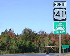 US 41 near the junction with US 141/M-28
 -
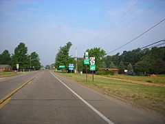
 Lake Michigan Circle Tour near US 10's crossing in Manitowoc, Wisconsin
 -
 Lake Erie Circle Tour along PA 5 in Erie County, Pennsylvania, which is also part of theBicyclePA Route Z
 -
 Lake Superior and Lake Huron Circle Tours cross the Sault Ste. Marie International Bridge


See also
 Roads portal
 U.S. Roads portal
 Michigan Highways portal
References
- ^ a b c Great Lakes Commission. "Great Lakes Circle Tour". Great Lakes Commission. Archived from the original on July 25, 2010. Retrieved March 8, 2008.
- OCLC 42778335. Archived from the originalon August 27, 2019. Retrieved August 26, 2019 – via Archives of Michigan.
- ^ Geomatics Office (1990). Ontario Official Road Map (Map). Government of Ontario.
- ^ a b Great Lakes Commission. "Great Lakes Circle Tour: Lake Superior". Great Lakes Commission. Retrieved March 8, 2008.
- ^ a b c d Great Lakes Commission. "Great Lakes Circle Tour: Lake Michigan". Great Lakes Commission. Retrieved April 20, 2008.
- ^ Office of Management and Budget. List II Consolidated Metropolitan Statistical Areas and Primary Metropolitan Statistical Areas (PDF) (Report). Executive Office of the President. Archived from the original (PDF) on September 13, 2001. Retrieved November 29, 2011.
- ^ a b c d Indiana 2009 Travel Guide. Indianapolis: State of Indiana. 2009.
- ^ a b Northwest Indiana Bike Map (Map) (Spring ed.). Northwestern Indiana Regional Planning Commission. 2008.
- ^ a b Moore, Powell A. (1959). The Calumet Region, Indiana's Last Frontier. Indiana Historical Bureau.
- ^ a b c Michigan Department of Transportation (2023). Michigan: Official 2023 Michigan Transportation Map (PDF) (Map). c. 1:975,000. Lansing: Michigan Department of Transportation.
- ^ a b Bessert, Christopher J. (January 1, 2009). "Lake Huron Circle Tour". Michigan Highways. Retrieved July 18, 2009.[self-published source]
- OCLC 42778335.
- ^ Fling, Jake (October 10, 2010). "Travel the Great Lakes Seaway Trail". Erie Times-News. Retrieved November 20, 2010.
- ^ Mitchell, Teresa (June 18, 2010). "June 22–24 Great Lakes Seaway Trail Reveal & Economic Impact Road Show Visits Six Communities on America's Byway" (Press release). Seaway Trail, Inc. Archived from the original on January 6, 2011. Retrieved November 20, 2010.
- ^ Davis, R. Matt (May 1, 1986). "Signs to Mark Lake Circle Tour". Daily Mining Gazette. Houghton, MI. p. 16.
- ^ Great Lakes Commission. "Tourism: The Great Lakes Circle Tour on GLIN!". Great Lakes Commission. Archived from the original on February 16, 2008. Retrieved March 8, 2008.
Works cited
- Indiana 2009 Travel Guide. Indianapolis: State of Indiana. 2009.
- Northwest Indiana Bike Map (Map) (Spring ed.). Northwestern Indiana Regional Planning Commission. 2008.
- Indiana (Map). Delormes Maps.
External links
- Official website
- Great Lakes Circle Tour - General information site on the GLCT and its component routes
Great Lakes of North America | |||||||||||||
|---|---|---|---|---|---|---|---|---|---|---|---|---|---|
| Main lakes | |||||||||||||
| Secondary lakes | |||||||||||||
| Bays and channels |
| ||||||||||||
| Waterways | |||||||||||||
| Islands | |||||||||||||
| Historic geology | |||||||||||||
| Organizations |
| ||||||||||||
| Related topics |
| ||||||||||||