
Kfar Saba
Kfar Sava
כְּפַר סָבָא | |
|---|---|
City (from 1962) | |
| Hebrew transcription(s) | |
| • ISO 259 | Kfar Sava |
| • Translit. | Kfar Sava |
 | |
 Flag  | |
 Kfar Sava  Kfar Sava | |
| Coordinates: 32°10′17″N 34°54′30″E / 32.17139°N 34.90833°E | |
| Country | |
| District | Central |
| Founded | 1903 |
| Government | |
| • Mayor | Rafi Saar |
| Area | |
| • Total | 14,169 dunams (14.169 km2 or 5.471 sq mi) |
| Population (2022) | |
| • Total | 101,556 |
| • Density | 7,200/km2 (19,000/sq mi) |
| Website | www |
Kfar Saba (
History of modern Kfar Saba
.jpg)
The village of
Beginnings (1898–1913)
In 1898, the Jewish town of Kefar Sava (Kfar Saba) was established as a moshava on 7,500 dunams of land purchased from the Arab village.[5] It was located approximately 3 km to the west of the Arab village of Kafr Saba, after which it was named. Despite attractive advertisements in Jerusalem and London, attempts to sell plots to private individuals were unsuccessful, as the land was located in a desolate, neglected area far from any other Jewish settlement.[3] Starting in 1903, Jewish workers resided on the site of Kfar Saba.[6] The Ottoman pasha of Nablus, to whose governorate the land belonged, refused to give building permits, therefore the first settlers lived in huts made of clay and straw. They earned their living by growing almonds, grapes and olives. A well was dug in 1906. Most of the manual laborers on the land were peasants from Qalqilya.[3] In 1910, an Arab guard employed by the landowners shot at a group of almond thieves from Qalqilya, killing one. An Arab mob then descended on Kfar Saba, beating residents, breaking and looting equipment, and taking two Jewish guards prisoner.[7][8] The situation was defused when reinforcements from Petah Tikva arrived, and a peace was negotiated. This attack drew widespread public attention among Jews in Palestine and around the world, and it was subsequently decided to turn Kfar Saba into a permanent settlement, even without building permits. In 1912, the construction of twelve single-story permanent houses began along a route that is now Herzl Street. The houses were camouflaged due to the lack of building permits. Construction was finished in 1913.[9]

World War I
When

In the
British Mandate
Following Kfar Saba's destruction in World War I, residents began rebuilding the town. During the
In August 1947, a Jewish man was found shot to death outside the town.[11]
-
 Paving a street in Kfar Saba, 1929
 -
 Kfar Saba 1930
 -
 Kfar Saba 1934
 -
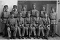 Kfar Saba police 1933
 -
 Kfar Saba 1938
 -
 Kfar Saba immigrant housing 1945


1947–48 war
In December 1947, as the civil war between the Arab and Jewish communities got underway, leaders of both sides in the area pledged to keep the peace between the local communities.[12] In the following months, Kfar Saba was attacked by local Arab militia from the nearby Arab village of Kafr Saba. The Arab Liberation Army (ALA), an outfit consisting of volunteers from several neighboring Arab countries, sent troops to aid in these attacks.[13]
The village was depopulated of its Arab residents by
-
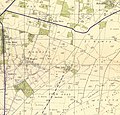 Kfar Saba 1942 1:20,000
 -
 Kfar Saba 1945 1:250,000


State of Israel

In May 1948, when Israeli independence was declared, Kfar Saba had a population of approximately 5,500. Following the war, it rapidly expanded as many Jewish
The rapid growth of the town meant that its status as a moshava was outdated, and it was granted city status in 1962, with head of the local council, Mordechai Surkis, becoming its first mayor.[16] The city had a population of 19,000 at the time. After receiving its city status, a court, a police branch, and offices of the National Insurance Institute and the Israel Tax Authority were established in Kfar Saba. Agriculture also continued to decline in importance in the city's economy as new factories were built. Despite this, the city still had thousands of acres of orchards in the late 1960s.[citation needed]
During the Six-Day War in 1967, two neighborhoods in Kfar Saba were shelled by Jordanian artillery, and an attack on a factory by Jordanian warplanes killed four workers. Following the war, the population increased as many people moved to Kfar Saba from the Gush Dan area, and during Soviet-Jewish immigration to Israel in the early 1970s, the city took in many Soviet immigrants and established an immigrant absorption center. In 1977, Kfar Saba had a population of 35,000.[citation needed]
First and Second Intifada
Kfar Saba is located just across the
Demographics

The 1922 census of Palestine listed the population of Kfar Saba as 14 Jews.[20] By the 1931 census it had grown to 1,405 inhabitants, all Jews, in 395 houses.[21]
In the 1945 statistics, the town had a population of 4,320 Jews.[22][23]
According to the
The city is ranked high on the socio-economic scale (8 out of 10).[24] Kfar Saba has a listed population surpassing 110,000 as of 2019[update].
Economy

According to CBS, there were 31,528 salaried workers and 2,648 self-employed in Kfar Saba in 2000. The mean monthly wage in 2000 for a salaried worker was
In May 2004 the exploration company Givot Olam Oil said that the Meged-4 oil well, located northeast of Kfar Saba, has exceeded original predictions and contains an extremely valuable deposit of oil.[25]
Schools and religious institutions
Currently, in Kfar Saba there are 18 elementary schools (5 of them are religious elementary schools),[26] 8 middle schools (2 of them are religious middle schools)[27] and 11 high schools (4 of them are religious high schools).[28] The high schools in Kfar Saba are divided to 3 groups: urban high schools (5), ORT high schools (2) and religious high schools (4).
The city is served by 105 synagogues.[29]
Health care
Environmental issues


Kfar Saba has won multiple awards for environment protection efforts. Kfar Saba is also the site of Israel's first biofilter project.[33]
Landmarks
Nabi Yamin


A
First well
The modern development of Kfar Saba started when water was discovered in the early 1920s. The first well was excavated at this time, followed by many others over the next two decades. The Kfar Saba Water Plant was founded to centralize the water supply system. The city's first well is located in the courtyard of Kfar Saba City Hall.[38]
Amrami's dairy farm
The site of the dairy farm of Baruch Amrami, who transferred the administration of the Kfar Saba settlement from Petah Tikva to a local committee and founded the water company and the first bank of the village in the 1920s, is on the corner of Amrami and Rothschild Streets. The cowshed and Amrami's "office" are still standing.[39]
Nordenstein house
Due to the lack of security during World War I, the settlement was abandoned. In 1922, the Nordenstein family returned and built the first defensible stone house. It took another two years for other families to return (mostly from Petah Tikva). The Nordenstein House is still standing on HaEmek Street, near the central bus station.[citation needed]
Kibbutz HaKovesh dining hall
A stone house on Tel Hai Street designed for defense (outlooks and sharp-shooting parapets) served as the communal dining room of Kibbutz HaKovesh. The pioneers themselves lived in tents. In 1948, the kibbutz moved north to secure the Kalkiliya front. The building now houses the Kfar Saba Civil Guard.[citation needed]
City's Park

Kfar Saba's Park is one of the biggest parks in the Sharon area. It has an area of 250,000 m2. The park includes kids playgrounds, water fountains, roller skate arena, fitness facilities, and shaded dining areas. The park is open daily between 6:30 am and 11:00 pm. There is free parking for city residents in different locations around the park.
Eva Fischer Fund
Located in the Kfar Saba's Municipality Center is the Eva Fischer Fund, which displays artworks about the Shoah given to the city by the Italian painter.
Archaeology
Remnants of an ancient Israelite village were discovered east of the city, and are believed to be the ruins of biblical Capharsaba. The Kfar Saba Archaeology Museum exhibits artifacts found in the region.[40]


Architecture
Kfar Saba is characterized by residential buildings with red tiled roofs. The use of red tiled roofs is evident in all types of buildings: private homes, high-rise buildings, businesses and industry. There is a widespread use of porches with arches, especially in front of the stores at Weizmann and Rothschild streets.
In 2014, the Kfar Saba Municipality decided to oblige every contractor who wants to build in the city area to install "green roofs." The meaning of green roofs is that solar panels will be installed on the roof to generate electricity from solar energy or a vegetable garden will be planted.[41][42]
Industry

Kfar Saba has one large industrial zone in the east of the city. It contains hi-tech offices and industrial plants, including Teva Pharmaceuticals' plant.
In popular culture
Kfar Saba was the primary filming location of FX's 2014-16 drama series Tyrant, which takes place in the fictional Arab country of Baladi.[43]
Twin towns – sister cities
Kfar Saba is twinned with:[44][45]
 Delft, Netherlands
 Gainesville, Florida, United States
 Jinan, China
 Mülheim an der Ruhr, Germany
 San José, Costa Rica
- Wiesbaden, Germany
Notable people
- Oz Almog (born 1956), Israeli-Austrian artist
- IDF Chief
- Linoy Ashram (born 1999), rhythmic gymnastics
- Avi Ben-Chimol (born 1985), basketball player
- Miki Berkovich (born 1954), basketball player
- Matti Caspi (born 1949), musician
- Galit Chait (born 1975), Olympic ice skater
- Nili Cohen (born 1947), professor and legal expert
- Yarden Gerbi (born 1989), judoka and Olympic bronze medalist
- Nina Pekerman (born 1977), athlete
- Sharren Haskel (born 1984), Member of Knesset
- Lehicofounder
- Moti Kirschenbaum, media personality
- David Klein, governor of the Bank of Israel
- Amos Lapidot (1934–2019), fighter pilot, 10th Commander of the Israeli Air Force, and President of Technion – Israel Institute of Technology
- Reshef Levi, writer and director
- Noam Mills (born 1986), female Olympic fencer
- Vicky Peretz (1953–2021), international Olympic footballer
- Idan Raichel (born 1977), musician
- Nakdimon Rogel, journalist and author of the Nakdi Report[46]
- Pinchas Sapir, politician
- Yuval Segal (born 1971), actor and comedian
- Ron Scherf (born 1972), Lt. Col. in Sayeret Matkal and co-founder of the Brothers in Arms protest movement
- Keren Siebner (born 1990), Olympic swimmer
- sport shooter
- Harel Skaat (born 1981), singer
- Manor Solomon, international association footballer (soccer player)
- Yaara Tal (born 1955), pianist
- Maor Tiyouri (born 1990), Olympic long distance runner
- Shelly Yachimovich, journalist and politician
- Israel Yinon, conductor
- Tomer Yosef, musician
- Lehicommander
_cropped.jpg)
.jpg)


.jpg)


References
- ^ "קובץ הרשויות המקומיות בישראל - 2018". www.cbs.gov.il (in Hebrew). Retrieved 2020-11-19.
- ^ a b The Origin of the Name Capharsaba Archived 2008-05-23 at the Wayback Machine Kfar Sava Municipal Council
- ^ a b c Vilnai, Ze'ev (1976). "Kefar-Sava". Ariel Encyclopedia (in Hebrew). Vol. 4. Israel: Am Oved. pp. 3790–96.
- ^ (Antiquities, book 13, chapter 15)
- ^ Hoffman, Carl (June 17, 2009). "Pride and preservation". The Jerusalem Post. Retrieved April 26, 2019.
- S2CID 236222143.
- ^ Kashran, Tzvi (August 12, 1910). מכתב מפתח תקוה [Letter from Petah Tikvah]. Hapoel Hatzair (in Hebrew). Retrieved April 26, 2019.
- ^ Ben-Yishai, Ron (March 21, 1983). לזכרו של ברוך פריבר [Remembering Baruch Freever] (in Hebrew). Retrieved April 26, 2019.
- ^ a b c "היסטוריה".
- ^ History Kfar Saba Municipal Council (in Hebrew)
- ^ Haganah Kills 11 in Palestine Hunt for Arab Gunmen New York Times, August 16, 1947
- ^ 6 Dead, 26 Injured in Haifa Fighting NY Times, December 25, 1947
- ISBN 9780300126969.
- ^ Benvenisti, 2002, p. 273
- ^ Morris, 2004, pp. 246-247
- ^ a b Mordechai Surkis: Public Activities Knesset website
- ^ Jessica Steinberg (2001-05-04). "Israeli yuppie town of Kfar Saba now finding itself on the front line of the battle with the Palesti". JWeekly.com. Jewish Telegraphic Agency. Retrieved April 26, 2019.
- ^ "security: Suicide attacks in Kfar Saba and Jerusalem kill one Israeli". israelinsider. 2002-03-17. Archived from the original on 2010-11-25. Retrieved 2009-05-05.
- ^ "Guard killed and 10 hurt in Israel suicide attack". The Independent. Associated Press. April 24, 2003. Retrieved April 26, 2019.
- ^ Barron, 1923, Table VII, Sub-district of Jaffa, p. 20
- ^ Mills, 1932, p. 14
- ^ Government of Palestine, Department of Statistics, 1945, p. 27
- ^ Government of Palestine, Department of Statistics. Village Statistics, April, 1945. Quoted in Hadawi, 1970, p. 52
- ^ "Local councils and municipalities, by socio-economic index, ranking and cluster membership" (PDF). 2003. Retrieved 2014-02-05.
- ^ Welcome to Givot Olam Oil Archived 2005-12-20 at the Wayback Machine Givot Olam
- ^ "בתי ספר יסודיים". www.kfar-saba.muni.il. Retrieved 2020-11-19.
- ^ "חטיבות ביניים". www.kfar-saba.muni.il. Retrieved 2020-11-19.
- ^ "תיכונים". www.kfar-saba.muni.il. Retrieved 2020-11-19.
- ^ "Kfar Saba community guide". Nbn.org.il. Retrieved 2014-02-05.
- ^ Horowitz, Ayala (May 7, 2007). שיבא - בית החולים הגדול בישראל [Sheba - Largest Hospital in Israel]. Makor Rishon (in Hebrew). Retrieved April 26, 2019.
- ^ "Meir Medical Center history". Archived from the original on June 18, 2011.
- ^ Meir Maternity Ward Staff Save 20 Year-Old Arab Mother[permanent dead link]
- ^ Leader, Avraham; Bar-Lev, Ahuva (May 15, 2011). "Kfar Sava biofilter successfully concludes first winter". The Jerusalem Post. Retrieved April 26, 2019.
- ^ (in Hebrew)Yoav Regev (יואב רגב), ed., The New Israel Guide (מדריך ישראל החדש), vol. 8, p. 94, 2001.
- ISBN 9789042909700. Retrieved 18 February 2014.
- ^ Benvenisti, 2002, p. 276
- ^ Benvenisti, 2002, p. 277
- ^ "The Kfar Saba water tower". Water-tower.co.il. 2011-11-29. Archived from the original on 2012-04-26. Retrieved 2014-02-05.
- ^ Deutch, Gloria (2008-01-03). "Streetwise: Rehov Amrami, Kfar Saba". The Jerusalem Post. Archived from the original on 2013-07-06. Retrieved 2009-03-04.
- ^ "המוזיאון הארכיאולוגי לתולדות כפר-סבא". cms.education.gov.il. Retrieved 2020-11-19.
- ^ "גגות ירוקים". www.kfar-saba.muni.il. Retrieved 2020-11-19.
- ^ לוי, דותן (2014-01-29). "רוצים היתר בנייה בכפר סבא? גדלו גינת ירק על הגג". כלכליסט - www.calcalist.co.il. Retrieved 2020-11-19.
- ^ Press, Viva Sarah (2014-01-23). "FX's New TV Series 'Tyrant' About Syrian Leader is made in Israel". Retrieved 25 April 2014.
- ^ "ערים תאומות". kfar-saba.muni.il (in Hebrew). Kfar Saba. Retrieved 2020-02-24.
- ^ "Kfar Saba/Qalqilya". gnvsistercities.org. Gainesville Sister Cities International. Retrieved 2020-02-24.
- Jerusalem Post. 2011-12-08. Retrieved 2011-12-12.
Bibliography
- Barron, J.B., ed. (1923). Palestine: Report and General Abstracts of the Census of 1922. Government of Palestine.
- Government of Palestine, Department of Statistics (1945). Village Statistics, April, 1945.
- Hadawi, S. (1970). Village Statistics of 1945: A Classification of Land and Area ownership in Palestine. Palestine Liberation Organization Research Center. Archived from the original on 2018-12-08. Retrieved 2009-07-03.
- Mills, E., ed. (1932). Census of Palestine 1931. Population of Villages, Towns and Administrative Areas. Jerusalem: Government of Palestine.
External links
- Official website (in Hebrew)
- Kfar Saba Museum (in Hebrew)
- Kfar Saba Portal (in Hebrew)
- Haaretz article - Lean and green
- Block plan of Kefar Sava, (cadastral map) with list of names, 1934 - Eran Laor Cartographic Collection, The National Library of Israel

| International | |
|---|---|
| National | |
| Geographic | |
| Other | |