
Median strip
This article has multiple issues. Please help improve it or discuss these issues on the talk page. (Learn how and when to remove these template messages)
|


A median strip, central reservation, roadway median, or traffic median is the reserved area that separates opposing
Regional terminology
There is no international English standard for the term. Median, median strip, and median divider island are common in North American and
In British English the central reservation or central median is the preferred usage; it also occurs widely in formal documents in some non-British regions such as South Africa, where there are other informal regional words (for example middelmannetjie, which originally referred to the hump between wheel ruts on a dust road).[1][2] Neutral section and central nature strip[citation needed] are coinages in Australian English.
Additionally, different terminology is used to identify traffic lanes in a multi-lane roadway. North American usage calls the leftmost lanes located closest to the roadway centerline the "inner" lanes, while British usage calls these lanes the "outer" lanes. Thus, it is less confusing to call these central lanes the "passing", "fast", or "overtaking" lanes in international contexts, instead of using the ambiguous inner/outer distinction. Regional differences between
Physical attributes

Some medians function secondarily as green areas and

In contrast to the median of a major road, those in urban areas often take the form of central traffic islands that rise above the roadway. These are frequently found on urban arterial roads. In their simplest form, these are just raised concrete curbs, but can also be landscaped with grass or trees or decorated with bricks or stones. Such medians are also sometimes found on more minor or residential streets, where they serve primarily as a traffic-calming or landscaping element rather than a safety enhancement to restrict turns and separate opposite directions of high-volume traffic flow.
In some areas such as
The medians of United States
Width
The central reservation in the United Kingdom and other densely populated European countries (where it is known by their local names) is usually no wider than a single lane of traffic. In some cases, however, it is extended. For instance, if the road is running through hilly terrain, the carriageways may have to be built on different levels of the slope. An example of this is on the M5 motorway as it climbs up the side of the Gordano Valley south of Bristol. In Birmingham and many other cities, suburban dual carriageways may have trees or cycle lanes in the middle as a wide central reservation.
Two examples on the UK road network where the carriageways are several hundred yards/metres apart, are on a section of the M6 between Shap and Tebay, which allows a local road to run between them, and on the M62 where the highest section through the Pennines famously splits wide enough to contain a farm.[6] The other major exception is the A38(M) Aston Expressway, which is a single carriageway of seven lanes, where the median lane moves to account for traffic flow (a system known as tidal flow or reversible lane).
With effect from January 2005 and based primarily on safety grounds, the UK's
In North America, and some other countries with large sparsely populated areas, opposing lanes of traffic may be separated by several hundred meters of fields or forests outside of heavily populated areas (an extreme example being the Trans-Canada Highway near Ernfold, Saskatchewan, Canada, where eastbound and westbound lanes go as far as 5 kilometres (3.1 mi) apart from each other), but converge to a lane's width of separation in suburban areas and cities. In urban areas, concrete barriers (such as Jersey barriers) and guard rails (or guide rails) are used.
In Dedham, Massachusetts, the Norfolk County Correctional Center (a state prison) is located entirely within a wide median of Massachusetts Route 128. This 502-bed facility was opened in 1993 as infill construction in the previously unused real estate that had been isolated by the divided highway in the early 1950s. An extreme example of a wide median can be found on Interstate 75 near Cincinnati, Ohio; nearly the entire village of Arlington Heights, as well as the downtown district of Lockland, are both located between the two directions of I-75.
Inverted median
Some freeways in North America include "inverted" medians, which separate roadways running in the opposite direction from the standard for the country they are located in. Roads are so designed for a number of reasons, including to save space or for the creation of continuous flow intersections.
- The north–south Golden State Freeway (I-5) in the Tehachapi Mountains of California between Los Angeles and the San Joaquin Valley. For several miles, the direction of traffic on both sides of the median is reversed — northbound traffic is on the western roadway and southbound traffic on the eastern roadway.
- I-85 in central North Carolina between Lexington and Thomasville features an inverted median, constructed so that an in-median, right-exit rest area can feature a historic bridge.
- I-77 in Charlotte, North Carolina, has a reverse median at its intersection over I-85 for on- and off-ramps without taking too much land from neighboring properties and without building many more bridges.
- I-84 used to have an inverted median through Waterbury, Connecticut, east of the 2-level "mixmaster" interchange with Route 8. This section of freeway was reconstructed in the 1970s, which eliminated the inverted median.
Inverted medians are also used in rare cases on local streets that historically had unusual traffic patterns, such as Bainbridge Street between 3rd Street and 5th Street in
Safety impact

An August 1993 study by the US Federal Highway Administration quantified the correlation between median width and the reduction of both head-on accidents and severe injuries. The study found that medians without barriers should be constructed more than 30 feet (9.1 m) wide in order to have any effect on safety, and that safety benefits of wider medians continue to increase to a width of 60 to 80 feet (18.3 to 24.4 m).[5]
A consequence of this finding is that decreasing the size of a median to 20 feet (6.1 m) from 30 feet (9.1 m) to add lanes to a highway may result in a less safe highway. Statistics regarding medians with barriers were not calculated in this study.[5]
Bus rapid transit
Central reservations may also be used for reserved bus lanes, as in Istanbul's Metrobus, Los Angeles's J Line and Bogotá's TransMilenio. Center-lane running and island platforms installed in the medium reduce conflicts with stopped and parked cars as well as pedestrians near the curb, thus speeding service.
Railway use
In some cases, the median strip of the highway may contain a train line, usually around major urban centers. This is often done to share a
-
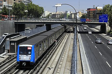
 Osaka Metro Midōsuji Linein the median.
 -
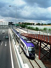
 TheMandurah railway line
 -

-
 A part of the in its median.
 -


Train lines that run in the median of highways include:
Asia
- Jingtong Expressway, respectively.
- Ayalon Highway.
- Toyonaka, Osaka and Kita-ku, Osaka.
- North Avenue in Quezon City.
- The Rooseveltinstead of North Avenue.
- The
- The under-construction Commonwealth Avenue, Regalado Avenue and Quirino Highway.
- Tuen Ma line between Shek Mun station and Tai Shui Hang station along the A Kung Kok Street.
Europe
- The
- The Ferrocarril de Sóller along Carrer Eusebi Estada in Palma de Mallorca
- The Pointe du Lac
- Line 25N from Brussels Airport junction to Mechelen along the E19
- The line from motorways to Amsterdam
- The Noord-Zuid metro line along the s116 Nieuwe Leeuwarderweg through Amsterdam-Noord
- The Ruhrschnellweg
- The Øresund Line along the E20 south of Malmö[7]
- The Cyprus station uses the median of the A1020 road in east London.
- The Manchester Metrolink between Ashton-under-Lyne and Ashton Moss runs along the A6140. It also runs through the roundabout.
North America
Canada
- The Line 1 Yonge–University along Allen Road in northwest Toronto, Ontario, Canada
- The Mascouche line along the median of the A 640 between Repentigny and Mascouche. Quebec, Canada.
- The Red Line of Calgary's CTrain light rail network is partially located in the median strip of the Crowchild Trail
- The King Street and Charles Street.
United States
- The Baltimore Metro Subway along a portion of I-795in Baltimore County
- Union Pacific through Tulsa, Oklahoma in the median of the Broken Arrow Expressway, between downtown and Interstate 44
- The Chicago Transit Authority's Red and Blue lines in the median of the Dan Ryan Expressway, the Kennedy Expressway, and Eisenhower Expressway in Chicago
- The H Line (RTD) built in the median of Interstate 225 from Interstate 25 to north of Parker Road in the Denver, Colorado metro area
- The Hardy Toll Road in Houston, Texas, has a rail line running down the median for a significant portion of its length.
- The Queens, New York; it runs north from John F. Kennedy International Airportbefore turning east at Jamaica Avenue
- The New Mexico Rail Runner on the median of Interstate 25 from CP Hondo into the state capital of Santa Fe, New Mexico
- The Georgia 400 between the northern Atlanta neighborhood, Lindbergh, Atlanta and Sandy Springs, Georgia
- The Interstate 205 in Maywood Park, Oregon.
- Missouri Pacific.
- The Arlington, Virginia
- The BNSF main line and Amtrak Coast Starlight and Cascades services between Seattle and Portland, OR use trackage in the median of Interstate 5just north of Woodland, Washington.
- The SEPTA Market–Frankford Line briefly runs in the median of the Delaware Expressway after it emerges from the Market Street Tunnel before continuing along Front Street.
- California
- Parts of Bay Area Rapid Transit outside San Francisco:
- Yellow Line (including eBART) along California State Route 24 and California State Route 4
- Interstate 238 and Interstate 580
- MacArthur station, a cross-platform interchange station where three lines meet in the median of State Route 24
- The Los Angeles Metro Rail
- The Interstate 105for majority of its length.
- The A Line runs in the median of Interstate 210 in Pasadena.
- The
- Metrolink
- The Interstate 710and El Monte.
- The Orange County Line, Inland Empire–Orange County Line, and Amtrak's Pacific Surfliner run in the median of Interstate 5 north of Oceanside, California.
- right-of-way.
- The
- The VTA Blue Line runs for much of its length in the medians of California State Route 87 and California State Route 85.
- Interstate 80 and includes park and ridefacilities at most of the stations in this section.
Oceania
- The Ellenbrook railway line will travel up the median strip of the Tonkin Highwayfor some of its length.
South America
- The Pan American Highway
City planners also commonly use median strips to accommodate urban
See also
References
- ISBN 978-0195705959
- ISBN 978-0-624-00533-9.
- ^ Buck, Thomas (September 28, 1969). "Ryan Rail Service Starts Today". Chicago Daily Tribune. p. 22.
- Spokesman-Review, April 28, 2014.
- ^ a b c Federal Highway Administration (August 1993). "The Association Of Median Width And Highway Accident Rate". Retrieved 2008-01-09.
- ^ Google Maps
- ^ Ortofoto (Map). Lantmäteriet. Retrieved 17 August 2018.
- ISBN 9781871236330.