
Pamplona
Pamplona
Iruña (Basque) Pampeluna | |
|---|---|
| Pamplona / Iruña | |
|
UTC+2 (CEST) | |
| Patron saint |
|
| Website | www |

.jpg)


Pamplona (Spanish pronunciation: [pamˈplona] ⓘ; Basque: Iruña [iɾuɲa]),[a] historically also known as Pampeluna in English, is the capital city of the Chartered Community of Navarre, in Spain.
Lying at near 450 m (1,480 ft) above sea level,
The city is famous worldwide for the
History

Foundation and Roman times
In the winter of 75–74 BC, the area served as a camp for the
Early Middle Ages

During the
Around 581, the Visigoth king Liuvigild overcame the Basques, seized Pamplona, and founded in the town of Victoriacum.
At the time of the
From 755 until 781, Pamplona remained autonomous, probably relying on regional alliances. Although sources are not clear, it seems apparent that in 778, the town was in hands of a Basque local or a Muslim rebel faction loyal to the Franks at the moment of
After the Frankish defeat at Roncevaux (778), Pamplona switched again to Cordovan rule, after Abd-al-Rahman's expedition captured the stronghold in 781. A wali or governor was imposed, Mutarrif ibn-Musa (a Banu-Qasi) up to the 799 rebellion. In that year, the Pamplonese—possibly led by a certain Velasko—stirred against their governor, but later the inhabitants provided some support for the Banu Qasi Fortun ibn-Musa's uprising. This regional revolt was shortly after suppressed by the Cordovan emir Hisham I, who re-established order, but failed to retain his grip on the town, since the Pamplonese returned to Frankish suzerainty in 806.[21] A Muslim cemetery containing about 200 human remains mingled with Christian tombs was unearthed in 2003 at the Castle Square, bearing witness to an important Muslim presence in the city during this period, but further research was stopped by the destruction of this and other historic evidence as decided by the city council, headed by mayor Yolanda Barcina.[22][23]
Following a failed expedition to the town led by
During this period, Pamplona was not properly a town, but just a kind of fortress. In 924,
The town only regained its urban and human shape after the end of raids by Vikings and Andalusians on the province. Especially after 1083, traffic on the
Three boroughs and one city
From the 11th century, reviving economic development allowed Pamplona to recover its urban life. The bishops of Pamplona recovered their ecclesiastical leading role; during the previous centuries, isolated
The boroughs showed very distinct features both socially and culturally, and were almost always engaged in quarrels among themselves. The most dramatic episode was the burning of the borough San Nicolás in 1258 and the destruction of the Navarrería by the other two boroughs and the massacre of its population in 1276. The site was abandoned for nearly 50 years. With regards to the outer defence walls of the city, the southern side was the weakest flank of the city, and the Navarrese king Louis I built a castle in the early 14th century in the site known today as Plaza del Castillo (Castle Square).
Eventually, King Charles III decreed the unification of the boroughs in a single city in 1423. The feuds between boroughs had been partly ignited by disputes over the use of the gulf dividing the three boroughs, so after Charles III's unification, the gulf was filled and on its site a common space laid out on the present-day city hall. The walls dividing the boroughs were demolished.
During the late 15th century, Pamplona bore witness to power struggles between the Beaumont and Agramont confederacies and external military interventions. Several times, the stronghold was taken over by different factions and foreign forces, like the ones sent by
Historically, a
-
 The Monumento a los Caídos, Francoist memorial, subject to debate about its potential demolition
 -
 Estafeta Street
 -
 Running of the Bulls
 -
 Seconds before the beginning of the San Fermín Festival—Town Hall Square: Everybody has a red handkerchief above their heads until a firework is exploded at 12 pm; putting it around their neck afterward


A fortress-city
After the
The progress of
During the 18th century, Pamplona was considerably beautified and its urban services improved. A continuous water supply was established and the streets were paved, among many other enhancements. Rich aristocrats and businessmen also built their mansions. In the 19th century, this fortress-city played a key role in several wars in which Spain was involved.
During the
.jpg)
During the Carlist Wars (1833–1839 and 1872–1876) Pamplona was each time controlled by the liberals, not just because the few liberals that lived in Navarre were mainly Pamplonese, but also because of the governmental control over the fortified city. Although Carlist rebels easily ruled the countryside, the government army had no problem in dominating the walled capital of Navarre. Nevertheless, during the last Carlist war, modern artillery operated by Carlists from surrounding mountains showed that the old walls would not be enough in the face of a stronger enemy. Thus, the government decided to build a fort on the top of mount San Cristóbal, just 3 km (1.9 mi) north of Pamplona.
Due to its military role, the city could not grow outside its walled belt. Furthermore, building in the closest area to the walls was banned to avoid any advantage for a besieger; thus the city could only grow by increasing its housing density. Higher and narrower houses were built and courtyards gradually disappeared. During the 19th century,
After a slight modification of the star fort allowed an expansion of just six blocks in 1888, the
Pamplona has in recent years taken great care to integrate and preserve its fortifications for modern use. In October 2014, working with the city of Bayonne, Pamplona hosts an international conference 'Fortified Heritage: Management and Sustainable Development', the website is in English, French, and Spanish.[32]
Available on a growing website are two free e-books, with copious colour photographs, on Pamplona's fortifications. Published in 2011 is 'Five living centuries of an impregnable fortress' about the city citadel[33] and 'A walk round the Pamplona fortifications'.[34]
Industrialization and modernization
.PNG)
Freed from its military function, Pamplona could lead the process of
Pamplona is listed as a city with one of the highest standards of living and quality of life in Spain.[35] Its industry rate is higher than the national average,[citation needed] although it is threatened by delocalization. Crime statistics are lower than the national average but cost of living, especially housing, is considerably higher.[36] Thanks to its small size and an acceptable public transport service, there are no major transport problems.
Geography
Pamplona is located in the middle of Navarre in a rounded valley, known as the

Climate
The climate of Pamplona is classified as an
| Climate data for Pamplona (1991–2020), extremes (1953–2020) | |||||||||||||
|---|---|---|---|---|---|---|---|---|---|---|---|---|---|
| Month | Jan | Feb | Mar | Apr | May | Jun | Jul | Aug | Sep | Oct | Nov | Dec | Year |
| Record high °C (°F) | 19.5 (67.1) |
23.6 (74.5) |
30 (86) |
29.6 (85.3) |
33.5 (92.3) |
38.5 (101.3) |
42.3 (108.1) |
40.6 (105.1) |
38.8 (101.8) |
30 (86) |
27 (81) |
20 (68) |
42.3 (108.1) |
| Mean maximum °C (°F) | 15.8 (60.4) |
18.1 (64.6) |
23.0 (73.4) |
25.8 (78.4) |
30.8 (87.4) |
35.1 (95.2) |
37.2 (99.0) |
37.1 (98.8) |
32.3 (90.1) |
26.7 (80.1) |
20.0 (68.0) |
15.8 (60.4) |
38.2 (100.8) |
| Mean daily maximum °C (°F) | 9.5 (49.1) |
11.2 (52.2) |
15.0 (59.0) |
17.2 (63.0) |
21.4 (70.5) |
25.8 (78.4) |
28.5 (83.3) |
29.2 (84.6) |
24.8 (76.6) |
19.7 (67.5) |
13.2 (55.8) |
9.9 (49.8) |
18.8 (65.8) |
| Daily mean °C (°F) | 5.7 (42.3) |
6.5 (43.7) |
9.5 (49.1) |
11.5 (52.7) |
15.2 (59.4) |
19.1 (66.4) |
21.6 (70.9) |
22.1 (71.8) |
18.5 (65.3) |
14.5 (58.1) |
9.2 (48.6) |
6.1 (43.0) |
13.3 (55.9) |
| Mean daily minimum °C (°F) | 1.8 (35.2) |
1.7 (35.1) |
4.0 (39.2) |
5.8 (42.4) |
8.9 (48.0) |
12.4 (54.3) |
14.6 (58.3) |
15.0 (59.0) |
12.2 (54.0) |
9.2 (48.6) |
5.2 (41.4) |
2.3 (36.1) |
7.8 (46.0) |
| Mean minimum °C (°F) | −3.8 (25.2) |
−3.4 (25.9) |
−1.4 (29.5) |
0.3 (32.5) |
3.1 (37.6) |
7.2 (45.0) |
9.8 (49.6) |
9.9 (49.8) |
6.4 (43.5) |
2.3 (36.1) |
−1.3 (29.7) |
−3.5 (25.7) |
−5.2 (22.6) |
| Record low °C (°F) | −12.4 (9.7) |
−15.2 (4.6) |
−9.0 (15.8) |
−2.2 (28.0) |
−0.2 (31.6) |
3.8 (38.8) |
7.0 (44.6) |
4.8 (40.6) |
3.4 (38.1) |
−1.0 (30.2) |
−6.6 (20.1) |
−14.2 (6.4) |
−15.2 (4.6) |
| Average precipitation mm (inches) | 73.5 (2.89) |
56.8 (2.24) |
65.5 (2.58) |
72.1 (2.84) |
60.6 (2.39) |
55.2 (2.17) |
33.6 (1.32) |
32.9 (1.30) |
46.2 (1.82) |
66.8 (2.63) |
85.6 (3.37) |
71.2 (2.80) |
720.1 (28.35) |
| Average precipitation days (≥ 1 mm) | 10 | 9 | 9 | 11 | 10 | 6 | 4 | 4 | 7 | 10 | 11 | 12 | 103 |
| Mean monthly sunshine hours | 114 | 130 | 191 | 204 | 237 | 259 | 302 | 287 | 230 | 179 | 117 | 104 | 2,354 |
| Source 1: Météo Climat[38] | |||||||||||||
| Source 2: Infoclimat [39] | |||||||||||||
| Climate data for Pamplona Airport(1981–2010), extremes (1953–2020) | |||||||||||||
|---|---|---|---|---|---|---|---|---|---|---|---|---|---|
| Month | Jan | Feb | Mar | Apr | May | Jun | Jul | Aug | Sep | Oct | Nov | Dec | Year |
| Record high °C (°F) | 19.5 (67.1) |
23.6 (74.5) |
30 (86) |
29.6 (85.3) |
33.5 (92.3) |
38.5 (101.3) |
40.2 (104.4) |
40.6 (105.1) |
38.8 (101.8) |
30 (86) |
27 (81) |
20 (68) |
40.6 (105.1) |
| Mean daily maximum °C (°F) | 9.1 (48.4) |
10.9 (51.6) |
14.6 (58.3) |
16.4 (61.5) |
20.8 (69.4) |
25.2 (77.4) |
28.2 (82.8) |
28.3 (82.9) |
24.5 (76.1) |
19.3 (66.7) |
13.1 (55.6) |
9.7 (49.5) |
18.4 (65.1) |
| Daily mean °C (°F) | 5.2 (41.4) |
6.3 (43.3) |
9.1 (48.4) |
10.9 (51.6) |
14.7 (58.5) |
18.6 (65.5) |
21.2 (70.2) |
21.4 (70.5) |
18.2 (64.8) |
14.1 (57.4) |
9.0 (48.2) |
6.0 (42.8) |
12.9 (55.2) |
| Mean daily minimum °C (°F) | 1.4 (34.5) |
1.6 (34.9) |
3.7 (38.7) |
5.3 (41.5) |
8.6 (47.5) |
11.9 (53.4) |
14.2 (57.6) |
14.5 (58.1) |
12.0 (53.6) |
8.9 (48.0) |
4.8 (40.6) |
2.2 (36.0) |
7.4 (45.3) |
| Record low °C (°F) | −12.4 (9.7) |
−15.2 (4.6) |
−9.0 (15.8) |
−2.2 (28.0) |
−0.2 (31.6) |
3.8 (38.8) |
7.0 (44.6) |
4.8 (40.6) |
3.4 (38.1) |
−1.0 (30.2) |
−6.6 (20.1) |
−14.2 (6.4) |
−15.2 (4.6) |
| Average precipitation mm (inches) | 62 (2.4) |
55 (2.2) |
59 (2.3) |
79 (3.1) |
65 (2.6) |
51 (2.0) |
38 (1.5) |
43 (1.7) |
49 (1.9) |
73 (2.9) |
80 (3.1) |
77 (3.0) |
734 (28.9) |
| Average precipitation days (≥ 1 mm) | 8.7 | 8 | 7.7 | 9.7 | 9.2 | 5.8 | 4.3 | 4.7 | 5.7 | 8.6 | 9.6 | 10.1 | 92.1 |
| Average snowy days | 2 | 2.6 | 1.4 | 0.8 | 0 | 0 | 0 | 0 | 0 | 0 | 0.7 | 1.5 | 9 |
| Average relative humidity (%)
|
78 | 72 | 66 | 65 | 63 | 59 | 57 | 58 | 62 | 69 | 76 | 78 | 67 |
| Mean monthly sunshine hours | 90.9 | 129.3 | 180.7 | 187.2 | 235.4 | 271.5 | 317.1 | 281.0 | 215.1 | 162.2 | 108.1 | 86.8 | 2,265.3 |
| Source 1: Agencia Estatal de Meteorología[40]
| |||||||||||||
| Source 2: Agencia Estatal de Meteorología[41]
| |||||||||||||
Urbanism
Like many other European cities, it is very easy to distinguish what is so called the "old city" and the new neighborhoods. The oldest part of the old city is Navarrería, which corresponds with the Roman city. During the 12th century, the boroughs of Saint Sernin (San Saturnino or San Cernin) and Saint Nicholas (San Nicolás) were established. Charles III decreed the unification of the three places under a single municipality in 1423.

The city did not expand until the late 19th century. In 1888, a modest modification of the star fort was allowed, but it just permitted the building of six blocks. It was called the I Ensanche (literally, "first widening"). The southern walls were destroyed in 1915 and the II Ensanche ("second widening") was planned. Its plan followed the
After the Civil War, three new zones of Pamplona began to grow: Rochapea, Milagrosa, and Chantrea. Only the last one was a planned neighborhood, the other two being disorderly growths. In 1957, the municipality designed the first general ordination plan for the city, which established the guidelines for further urban development. According to this, during the 1960s and 1970s saw the creation of new neighborhoods like San Juan, Iturrama, San Jorge, Etxabakoitz, and Orvina.

The urban expansion of Pamplona exceeded the administrative limits of the city and involved municipalities like
In recent years,
Economy

Pamplona has shifted in a few decades from a little administrative and even rural town to a medium-size city of industry and services. The
Pamplona is the main commercial and services centre of Navarre. Its area of influence is not beyond the province, except for the
Education and culture


The city is home to two universities: the above-mentioned
The two most important museums in Pamplona are the
Pamplona has hosted the Sarasate Violin International Competition biennially since 1991,[44] and the annual Punto de Vista International Documentary Film Festival, the most important Spanish documentary film festival, since 2004.
One of the more popular cultural expressions include the "
Politics
Following the 2023 municipal election, the mayor of the city is Joseba Asiron (EH Bildu), also supported by the Socialist Party of Navarre, Geroa Bai, and Contigo Zurekin.[45]
Transportation
Pamplona is linked by
The
Within the city and surroundings there are also 23 daytime lines and 10 night lines of public buses, operated by TCC, the chartered company of the Mancomunidad de la Comarca de Pamplona.
Main sights
Several notable churches, most of its 16th- to 18th-century fortified system and other civil architecture buildings belong to the historic-artistic heritage of Pamplona.
Religious architecture
The most important religious building is the fourteenth century
-
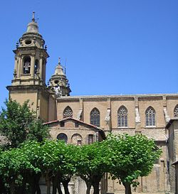 Pamplona Cathedral
 -
 San Lorenzo Church
 -
 San Ignacio Church
 -
 San Saturnino Church
 -
 San Nicolás Church


_01.jpg)


Military and civil architecture


From the prominent military past of Pamplona remain three of the four sides of the city walls and, with little modifications, the citadel or star fort. All the mediaeval structures were replaced and improved during 16th, 17th and 18th centuries in order to resist artillery sieges. Completely obsolete for modern warfare, they are used today as parks.
The oldest civil building today existing is a fourteenth-century house that was used as Cámara de Comptos (the court of auditors of the early modern autonomous kingdom of Navarre) from the sixteenth to the nineteenth century. There are also several medieval bridges on the Arga: Santa Engracia, Miluce, Magdalena, and San Pedro. The medieval palace of Saint Peter, which was alternatively used by Navarrese kings and Pamplonese bishops, was used during the early modern age as the Viceroy's palace and later was the seat of the military governor of Navarre; from the time of the Civil War it was in ruins but was recently rebuilt to be used as the General Archive of Navarre.
The most outstanding Baroque civil architecture is from the eighteenth century: town hall, episcopal palace, Saint John the Baptist seminary, and the Rozalejo's, Ezpeleta's (today music school), Navarro-Tafalla's (today, the local office of
Late nineteenth and early twentieth century Pamplonese architecture shows the tendencies that are fully developed in other more important Spanish cities: La Agrícola building (1912), several apartment buildings with some timid modernist ornamentation, etc. The most notable architect in twentieth century Pamplona was Víctor Eusa (1894–1990), whose designs were influenced by the European expressionism and other avant-garde movements.
Parks
Pamplona has many parks and green areas. The oldest is the Taconera park, whose early designs are from the seventeenth century. Taconera is today a romantic park, with wide pedestrian paths,
The Media Luna park was built as part of the II Ensanche and is intended to allow relaxing strolling and sightseeing over the northern part of the town.
After its demilitarization, the citadel (Ciudadela) and its surrounding area (Vuelta del Castillo) shifted into a park area with large lawns and modern sculptures.
The most remarkable parks of the new neighborhoods include the Yamaguchi park, between Iturrama and Ermitagaña, which includes a little
Sports

Pamplona's bull ring, the Plaza de Toros de Pamplona, was rebuilt in 1923. It seats 19,529 and is the third largest in the world, after the bull rings of Mexico City and Madrid.
There are two football teams in Pamplona. CA Osasuna (Club Atlético Osasuna (Basque for "Health")) who play professionally in La Liga, and CD Pamplona who play in Tercera Federación. Osasuna play their home games at El Sadar Stadium.
Other notable sports teams in Pamplona include
).The
Pamplona is also home to the headquarters of the International Federation of Basque Pelota (FIPV). Basque pelota is principally practiced in France, Spain, and North and South America, but also in other countries like Italy and Philippines.
Notable Athletes
Five time
Former Arsenal goalkeeper Manuel Almunia was born in Pamplona and started his career at CA Osasuna.
Notable citizens
- Fermin (* 272; † 303)
- Martín de Rada, (1533–1578)
- Pablo de Sarasate (1844–1908), internationally renowned composer and violin player
- José Sanjurjo (1872–1936), army general
- Joaquín Beunza Redín (1872-1936), Carlist politician
- Víctor Pradera Larumbe (1873–1936), Carlist politician
- Ignacio Baleztena Ascárate (1887–1972), Carlist politician
- Luis Arellano Dihinx (1906–1969), Carlist politician
- Sabicas (1912–1990)
- Jaime del Burgo Torres (1912–2005), Carlist politician
- Alfredo Landa (1933–2013)
- Marysa Navarro (born 1934)
- Carlos Garaikoetxea (born 1938)
- Javier Rojo (born 1949)
- Serafín Zubiri (born 1964), singer
- Jon Andoni Goikoetxea (born 1965), Spain footballer
- Alberto Urroz (born 1965), classical pianist
- Cesar PalaciosChocarro (born 1974), Spain footballer
- Javier López Vallejo (born 1975), Spain footballer
- Francisco Puñal (born 1975), Spain footballer
- Tiko (born 1976), Spain footballer
- Manuel Almunia (born 1977), Spain footballer
- Jesús María Lacruz (born 1978), Spain footballer
- Gorka Iraizoz (born 1981), Spain footballer
- Miguel Flaño (born 1984), Spain footballer
- Javier Flaño (born 1984), Spain footballer
- Fernando Llorente (born 1985), Spain footballer
- María Hernández (born 1986), Spanish professional golfer
- Raúl García (born 1986), Spain footballer
- Nacho Monreal (born 1986), Spain footballer
- Abel Azcona (born 1988), Contemporary artist
- César Azpilicueta (born 1989), Spain footballer
- Carlota Ciganda (born 1990), Spanish professional golfer
- Iker Muniain (born 1992), Spain footballer
- Mikel Merino (born 1996), Spain U21 footballer
- Amaia Romero(born 1999), singer
- Nico Williams (Born 2002), Spain footballer
- Oihan Sancet (Born 2000), Spain footballer
- Javier Garro Barrio (1933 - 2003)
Twin towns and sister cities
Pamplona is
Notes
- ^ Iruñea is the Basque name proposed by the Royal Academy of the Basque Language, but the Basque name recognized by the Government of Navarre is Iruña.
References
 This article incorporates text from a publication now in the public domain: Smith, William, ed. (1854–1857). "William Smith". Dictionary of Greek and Roman Geography. London: John Murray.
- Collins, Roger (1990). The Basques. Cambridge, Mass.: Basil Blackwell. ISBN 0-631-17565-2.
- ^ "Municipios: Pamplona/Iruña". Retrieved 13 July 2020.
- ^ "Población total Pamplona/Iruña a 2 de enero de 2020" (PDF). Archived from the original (PDF) on 6 August 2020. Retrieved 13 July 2020.
- ^ "Gross domestic product (GDP) at current market prices by metropolitan regions". ec.europa.eu.
- ^ "Fiesta de San Fermín". Encyclopædia Britannica. Retrieved 2016-08-07.
- ISBN 84-89483-12-4.
- S2CID 134630943.
- ^ Cañada Palacio 1999, p. 189.
- ISBN 84-8136-300-6.
- ^ Cañada Palacio 1999, p. 191.
- ^ Ptolemy ii. 6. § 67; Strabo iii. § 161
- ^ Antonine Itinerary p. 455
- ^ Pliny the Elder iii. 3. s. 4.
- ^ Collins 1990, p.76
- ^ Collins 1990, p.102
- ISBN 84-8136-017-1.
- ISBN 84-8136-017-1.
- ^ Collins 1990, p.154
- ^ Collins 1990, p.116
- ^ Collins 1990, p.117
- ^ Collins 1990, p.119
- ^ Collins 1990, p.124
- ^ Rekalde, Angel (2014-01-08). "Las piedras de la plaza del Castillo". Noticias de Navarra. Pamplona. Archived from the original on 2014-08-18. Retrieved 2014-08-18.
- ^ "El informe pericial de Aranzadi denuncia 'un expolio' arqueológico en la Plaza del Castillo". El País. 2002-02-16. Retrieved 2014-08-02.
- ISBN 84-235-2506-6.)
{{cite book}}: CS1 maint: multiple names: authors list (link - ISBN 84-8136-017-1.
- ISBN 84-235-2506-6.)
{{cite book}}: CS1 maint: multiple names: authors list (link - ^ "Pamplona". Jewish Virtual Library. Retrieved 25 June 2024.
- ^ Singer, Isidore; Kayserling, Meyer. "PAMPLONA". The Jewish Encyclopedia. Retrieved 25 June 2024.
- ^ [dead link]"200 años de la caída de la Ciudadela". Diario de Noticias. Archived from the original on November 17, 2011. Retrieved 2008-02-17. Article in Spanish
- ^ Porter, Maj Gen Whitworth (1889). History of the Corps of Royal Engineers Vol I. Chatham: The Institution of Royal Engineers.
- ^ congress.fortiuspamplonabayonne.eu Archived 2014-04-13 at the Wayback Machine
- ^ "The Citadel of Pamplona". 6 May 2014.
- ^ "San Bartolome Fort". 6 May 2014.
- ^ "Pamplona, Bilbao and Gijón, the Spanish cities with the best quality of life". El Mundo (in Spanish). 2007-06-21. Retrieved 2008-04-14.
- ^ (in Spanish) habitathumano.com Archived 2007-02-21 at the Wayback Machine
- ^ "Pamplona, Spain Climate Summary". Weatherbase. Retrieved 5 April 2015.
- ^ "Météo climat stats Moyennes 1991/2020 Espagne (page 3)" (in French). Retrieved 3 June 2022.
- ^ "Climatologie de l'année à Pamplona/Noain" (in French). Infoclimat. Retrieved 17 September 2023.
- ^ "Standard Climate Values for Pamplona". Retrieved 13 July 2020.
- ^ "Extreme Climate Values for Pamplona". 13 July 2020.
- ^ (in Spanish) Cener.com
- ^ See University of Navarre, Notable rankings
- ^ "Sarasate Live!". sarasatelive.com. Archived from the original on 30 May 2016. Retrieved 9 July 2016.
- ^ "Joseba Asiron (EH Bildu), nuevo alcalde de Pamplona". Ayuntamento de Pamplona / Iruñeko Udala (in Spanish). 28 December 2023. Retrieved 29 June 2024.
- ^ (in Spanish) History of the Airport of Pamplona, by Aena Archived 23 February 2012 at the Wayback Machine
- ^ "2009 Riders and teams Database - Cyclingnews.com". Retrieved 2009-08-14.
- ^ "National Commission for Decentralised cooperation". Délégation pour l’Action Extérieure des Collectivités Territoriales (Ministère des Affaires étrangères) (in French). Archived from the original on 2013-10-08. Retrieved 2013-12-26.
Bibliography
External links
- Official website
 (in Spanish)