
Valles Marineris
outflow channels extend from the east end of Valles Marineris towards Mars's northern lowlands. | |
| Coordinates | 13°54′S 59°12′W / 13.9°S 59.2°W |
|---|---|
| Length | over 4,000 km (2,500 mi) |
| Naming | Mariner 9 |
Valles Marineris (
Valles Marineris is located along the equator of Mars, on the east side of the
It has been recently suggested that Valles Marineris is a large tectonic "crack" in the Martian crust.[6][7] Most researchers agree that this formed as the crust thickened in the Tharsis region to the west, and was subsequently widened by erosion. Near the eastern flanks of the rift, there appear to be channels that may have been formed by water or carbon dioxide. It has also been proposed that Valles Marineris is a large channel formed by the erosion of lava flowing from the flank of Pavonis Mons.[8]
Formation
The most agreed upon theory today is that Valles Marineris was formed by
The first stage consisted of a combination of volcanism and


Former theories of formation
Theories about the formation of Valles Marineris have changed over the years.[11] Ideas in the 1970s were erosion by water or thermokarst activity, which is the melting of permafrost in glacial climes. Thermokarst activity may have contributed, but erosion by water is a problematic mechanism because liquid water cannot exist in most current Martian surface conditions, which typically experience about 1% of Earth's atmospheric pressure and a temperature range of 148 K (−125 °C; −193 °F) to 310 K (37 °C; 98 °F). Many scientists however agree that liquid water flowed on the Martian surface in the past, when atmospheric conditions were different. Valles Marineris may have been enlarged by flowing water at that time. Another hypothesis by McCauley in 1972 was that the canyons formed by withdrawal of subsurface magma. Around 1989, a theory of formation by tensional fracturing was proposed.
Regions of Valles Marineris

Noctis Labyrinthus

Noctis Labyrinthus, on the western edge of the Valles Marineris Rift System, north of the Syria Planum and east of Pavonis Mons, is a jumbled terrain composed of huge blocks which are heavily fractured. It also contains canyons that run in different directions surrounding large blocks of older terrain. Most of the upper parts of the blocks are composed of younger fractured material thought to be of volcanic origin associated with the Tharsis bulge. The other tops are composed of older fractured material thought also to be volcanic in origin, but differentiated from the younger material by more ruggedness and more impact craters. The sides of the blocks are composed of undivided material thought to be basement rock. The space between the blocks is composed mainly of either rough or smooth floor material. The rough floor material tends to be in the eastern portion of the Noctis Labyrinthus and is thought to be debris from the walls or maybe eolian features covering rough topography and landslides. The smooth floor material is thought to be composed of fluvial or basaltic material and/or eolian features covering an otherwise rough and jumbled terrain.[12] Terrains such as Noctis Labyrinthus are commonly found at the head of outflow channels, like the one explored by the Pathfinder mission and its Sojourner rover. They are interpreted to be a place of downward block faulting associated with the removal of ground fluid in catastrophic flood sequences.[13] The fluid could be either carbon-dioxide ice and gas, water or lava. The hypothesis of lava involvement is associated with a proposal that Noctis Labyrinthus is directly connected to lava tubes on the slope of Pavonis Mons.[8] In 2024, scientists found evidence that the hypothesized lava came from a volcano they dubbed Noctis Mons, which would be the seventh-highest mountain on Mars at 9,028 m (29,619 ft), and that the eastern part of its base was home to multiple glaciers with potential for hosting life, which could make it a highly valuable candidate target for astrobiology missions. [14] [15]
-
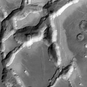 Part of Noctis Labyrinthus taken with Mars Global Surveyor.
 -
 Layers in the wall of Noctis Labyrinthus taken with Mars Global Surveyor, under the MOC Public Targeting Program.
 -
 Section of layers near top of Noctis Labyrinthus, as seen by HiRISE under the HiWish program.
 -
 Group of layers near the bottom of Noctis Labyrinthus, as seen by HiRISE under the HiWish program.
 -
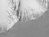
 Wide view of cliff with layers in Noctis Labyrinthus.
 -
 Close-up of part of previous image of layers in Noctis Labyrinthus, as seen by HiRISE under the HiWish program.
 -
 Close-up of complex, dark dunes in the previous image of the floor of Noctis Labyrinthus, as seen by HiRISE under the HiWish program.
 -
 Close-up of some layers in wall of Noctis Labyrinthus, as seen by HiRISE under the HiWish program.


Ius and Tithonium chasmata

Further to the east from Oudemans,
Melas, Candor and Ophir chasmata

The next portion of Valles Marineris to the east are three chasmata, that from south to north are Melas, Candor and Ophir chasmata. Melas is east of Ius, Candor is east of Tithonium and Ophir appears as an oval that runs into Candor. All three chasmata are connected. The floor of Melas Chasma is about 70% younger massive material that is thought to be volcanic ash whipped up by the wind into eolian features. It also contains rough floor material from the erosion of the canyon walls. Also, in these central chasmata there is a portion of the floor that is higher than the rest of the floor, most likely left by the continued dropping of the other floor material. Around the edges of Melas is also a lot of slide material as seen in Ius and Tithonium chasmata.[12]
The material of the floor of the canyon system between Candor and Melas chasmata is grooved. This is interpreted to be
Coprates Chasma


Further to the east, the canyon system runs into Coprates Chasma, which is very similar to Ius and Tithonium chasmata. Coprates differs from Ius in the eastern end which contains alluvial deposits and eolian material[12] and like Ius, has layered deposits, although the deposits in the Coprates Chasma are much more well defined. These deposits pre-date the Valles Marineris system, suggesting erosion and sedimentary processes later cut by the Valles Marineris system. Newer data from Mars Global Surveyor suggest that the origin of this layering is either just a succession of landslides, one over another, volcanic in origin, or it may be the bottom of a basin of either liquid or solid water ice suggesting that the peripheral canyons of the Valles Marineris system could have been at one time isolated lakes formed from erosional collapse. Another possible source of the layered deposits could be wind-blown, but the diversity of the layers suggests that this material is not dominant. Note that only the upper layers are thin, while the bottom layers are very big, suggesting that the lower layers were composed of mass wasted rock and the upper layers come from another source.[17] Some of this layering may have been transferred to the floor by landslides in which the layers are kept semi-intact, yet the layered section looks highly deformed with thickening and thinning beds that have multitudes of folds in them as seen in MOC image #8405. This complex terrain could also be just eroded sediment from an ancient Martian lake-bed and appear complex because all that we have is an aerial view like a geologic map and not enough elevation data to see if the beds are horizontal.
Near 60° W is the deepest point of the Valles Marineris system (as well as its lowest point by elevation) at 11 km (36,000 ft) below the surrounding plateau. Eastward from here there is about a 0.03 degree slope upward before reaching the outflow channels, which means that if you poured fluid into this part of the canyon, it would form a lake with a depth of 1 km (3,300 ft) before spilling over towards the northern plains.[18]
A field of more than 100 pitted cones on the floor of Coprates Chasma has been interpreted as a set of small igneous
Eos and Ganges chasmata

Further to the east lie Eos and Ganges chasmata. Eos Chasma's western floor is mainly composed of an etched massive material composed of either volcanic or eolian deposits later eroded by the Martian wind. The eastern end of the Eos chasma has a large area of streamlined bars and longitudinal striations. This is interpreted to be stream-carved plateau deposits and material transported and deposited by flowing fluid. Ganges Chasma is an offshoot chasma of Eos in a general east–west trend. The floor of Ganges is mainly composed of alluvial deposits from the canyon walls.[12]
Chryse region
East of Eos and Ganges, Valles Marineris empties out into the
The outflow occurs successively through several regions of chaotic terrain, Aurorae Chaos and Hydraotes Chaos, and finally through Simud Valles and Tiu Valles into Chryse Planitia.[13][22]
Interactive Mars map

See also
- Geography of Mars
- Lakes on Mars
- Vallis
- Mars carbonate catastrophe
Notes
- ^ "Valles Marineris". Dictionary.com Unabridged (Online). n.d.
- USGS Astrogeology Science Center. Retrieved 2015-02-28.
- ^ "Vallis Marineris". Goddard Space Flight Center. NASA. 2002. Archived from the original on 2007-07-11. Retrieved 2018-01-22.
- ^ "Valles Marineris". NASA. 2005. Retrieved 2018-01-22.
- ^ "Valles Marineris: The Grand Canyon of Mars". NASA. 2008-03-23. Retrieved 2024-01-25.
- ^ Wolpert, Stuart (2012-08-09). "UCLA scientist discovers plate tectonics on Mars". UCLA. Retrieved 2012-08-13.
- doi:10.1130/L192.1.
- ^ .
- ISBN 0-19-521726-8.
- ^ a b Akers, C.; Schedl, A. D.; Mundy, L. (2012). "What Caused the Landslides in Valles Marineris, Mars?" (PDF). 43rd Lunar and Planetary Science Conference. p. 1932. Retrieved 2013-02-11.
- ^ Cabrol, N. and E. Grin (eds.). 2010. Lakes on Mars. Elsevier. NY
- ^ a b c d e f Witbeck, Tanaka and Scott, Geologic Map of the Valles Marineris Region, Mars; USGS I-2010; 1991.
- ^ PMID 26346067.
- ^ "Giant Volcano Discovered on Mars". SETI Institute. March 13, 2024. Retrieved March 22, 2024.
- ^ "Remains of a Modern Glacier Found Near Mars' Equator Implies Water Ice Possibly Present at Low Latitudes on Mars Even Today". SETI Institute. March 15, 2023. Retrieved March 22, 2024.
- ^ Howard, Kochel and Holt; Sapping Features of the Colorado Plateau: A Comparative Planetary Geology Field Guide; NASA; 1988.
- ^ Cattermole, 113-114
- ^ Cattermole, 105
- ^ "Recent volcanic activity and hydrothermal minerals on Mars". Czech Academy of Sciences. 2017-07-19. Retrieved 2017-07-27.
- .
- ^ Cattermole, 126
- ^ United States Geological Survey Mars topographic map with feature names
References
- Hoffman, Nick; White Mars: A New Model for Mars' Surface and Atmosphere Based on CO2; Academic Press; 2000.
- Malin Space Science Systems Home Page
- Malin Space Science Systems, science paper
External links
- Flight into Mariner Valley: Valles Marineris HD video (narrated) at YouTube or the ASU web site
- Google Mars scrollable map - centered on Valles Marineris
- Flying around Candor Chasma at an altitude of 100 meters (see MARS3DdotCOM album for more)
- Video simulation of high altitude Valles Marineris overflight by Seán Doran (see Mars playlist for more)
| International | |
|---|---|
| National | |