
Peace Vallis
IAU on September 26, 2012, after the Peace River in British Columbia and Alberta, Canada.[1] |
Peace Vallis is an ancient stream valley on the northern rim of
Location and Regional Context
The valley is centered at 4°13′S 137°14′E / 4.21°S 137.23°E
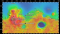
Gale crater itself is a 154-kilometer (96 mi)-diameter impact crater that straddles the martian hemispheric
The northern rim of Gale Crater is heavily eroded and hosts a number of geomorphic features indicating the effects of flowing water. These include valleys, gullies, and canyons; sinuous ridges interpreted to be inverted channels; and alluvial fan-like mesas.[10] Peace Vallis and its alluvial fan is the largest and best studied of these fluvial features in northern Gale Crater.
Name
Peace Vallis is named after the Peace River in Alberta and British Columbia, Canada. The name was adopted by the International Astronomical Union (IAU) on September 26, 2012. Vallis is the Latin word for valley.[1]
Valley and Drainage Basin
Peace Vallis is a valley network characterized by a branching (dendritic) pattern of tributary valleys that resembles river drainage basins on Earth. They are common on the older heavily cratered regions of Mars. Most planetary scientists agree that valley networks were formed by flowing water, but the source of the water is still debated.[11] Some argue that rainfall on a warm and wet early mars produced them.[12] Others have suggested they were produced by mass wasting,[13] spring sapping,[14] or from snowmelt[15] on an ancient Mars whose climate was dry and cold much like today's.
The Peace Vallis drainage basin (or catchment) covers an area of about 1,500 km2 (579 mi2). This area sits 1,300 m (4,265 ft)[5] above the crater floor and consists of gently sloping plains interspersed with hills roughly 100 to 350 m (328 to 1,148 ft) high. These irregular hills are mostly mantled with debris that appear to be some combination of aeolian deposits and colluvium.[16] Erosion of the watershed surface has produced a mottled scoured appearance, suggesting mobilization and transport of sediments into topographic lows.
Compared with most terrestrial valleys carved by rainfall, the drainage density (stream length per unit area) of Peace Vallis and its tributaries is very low. There is a lack of highly integrated fluvial channels,[17] and the areas between the tributary valleys (interfluves) are undissected by smaller valleys or gullies. The drainage density of the Peace Vallis system has been estimated to be 0.15 km–1.
The valleys are U-shaped in topographic profile, with widths ranging from 80 to 900 meters (262 to 2,950 feet) and a mean of 300 meters (984 feet). The main or trunk valley is about 32 km (20 miles) long.[16]

Curiosity rover landed near the end of the Peace Vallis fan. Peace Vallis fan covers 80 km2 (31 sq mi) and obtained water from an area of 730 km2 (280 sq mi). Peace Vallis enters Gale Crater through a 15 km-wide (9.3 mi) gap in its rim. Calculations suggest that the fan has an average thickness of 9 m (30 ft). Numerous inverted channels are visible on the western surface of the fan. Runoff through Peace Vallis that made the fan is estimated to be between 600 and 6,000 m (0.37 and 3.73 mi); therefore a hydrologic cycle probably lasted at least thousands of years. The water that flowed in Peace Vallis is believed to be from precipitation, possibly in the form of snow.[16]
Images
-
 Map of actual (and proposed) Rover landing sites includingGale Crater.
 -
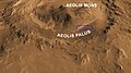 Aeolis Mons (Mount Sharp)- North is down.
 -
 Aeolis Mons(cutaway).
 -
 Mount Sharp- a planned area of study.
 -

-
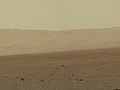
 Gale Crateras viewed by the Curiosity rover (August 6, 2012).
 -
 Layers at the base ofwhite balanced image).
 -
 white balanced image).
 -
 Gale Craterrim about 18 km (11 mi) North of the Curiosity rover (August 9, 2012).
 -
 First-Year and First-Mile Traverse Map of the Curiosity rover on Mars (August 1, 2013) (3-D).


.jpg)

_-_HiRISE_-_20120814.jpg)


See also
References
- ^ IAU. September 26, 2012. Retrieved September 28, 2012.
- ^ Newsom, H.E.; Scuderi, L.A.; Gallegos, Z.E.; Williams, J.M.; Dimitracopoulos, F.D.; Tornabene, L.L.; Wiens, R.C.; Gasnault, O. (2021). Evidence for Glacial and Fluvial Processes on Gale Crater Rim—Dulce Vallis. 52nd Lunar and Planetary Science Conference, Abstract #2256. https://www.hou.usra.edu/meetings/lpsc2021/pdf/2256.pdf.
- ISSN 0094-8276.
- ^ Williams, R.M.E.; Grotzinger, J.P.; Dietrich, W.E.; Gupta, S.; Sumner, D.Y. et al. (2013). Martian Fluvial Conglomerates at Gale Crater. Science, 340, 1068, doi: 10.1126/science.1237317.
- ^ a b Newsom, H.E.; Scuderi, L.A.; Gallegos, Z.E.; Tornabene, L.L.; Wiens, R.C. (2020). Evidence for Glacial Processes on Gale Crater Rim Surfaces from New HiRise Observations. 51st Lunar and Planetary Science Conference, Abstract #2609. https://www.hou.usra.edu/meetings/lpsc2020/pdf/2609.pdf.
- ^ Scuderi, L.A.; Gallegos, Z.E.; Newsom, H.E.; Wiens, R..C. (2019). Amazonian Groundwater Springline at Peace Vallis Fan, Gale Crater; Implications for a Late Period of Surface Habitability. Mars Extant Life: What's Next? Conference, Abstract #5043. https://www.hou.usra.edu/meetings/lifeonmars2019/pdf/5043.pdf.
- ^ Palucis, M.C.; Dietrich, W.E.; Hayes, A.; Williams, R.M.E. et al. (2013). Origin and Evolution of the Peace Vallis Fan System that Drains into the Curiosity Landing Area, Gale Crater. "44th Lunar and Planetary Science Conference", Abstract #1607. https://www.lpi.usra.edu/meetings/lpsc2013/pdf/1607.pdf.
- ^ Newsom, H.E.; Scuderi, L.A.; Gallegos, Z.E.; Nagle-McNaughton, T.P.; Tornabene, L.L. et al. (2019). Southern Watershed and Fluvial History of the Peace Vallis Fan System, Gale Crater, Mars. 9th International Conference on Mars, Abstract #6119. https://www.hou.usra.edu/meetings/ninthmars2019/pdf/6119.pdf.
- ^ Le Deit, L.; Hauber, E.; Fueten, F.; Pondrelli, M.; Pio Rossi, A.; Jaumann, R. (2013). Sequence of Infilling Events in Gale Crater, Mars: Results from Morphology, Stratigraphy, and Mineralogy. J. Geophys. Res., 118, 2439–2473, doi:10.1002/2012JE004322, 2013.
- ^ Anderson, R.B.; Bell, J.F. (2010). Geologic Mapping and Characterization of Gale Crater and Implications for Its Potential as a Mars Science Laboratory Landing Site. Mars, 5, 76–128.
- ^ Carr, M.H. The Surface of Mars; Cambridge University Press: New York, 2006
- ISSN 0148-0227.
- ^ Carr, M.H. (1995). The Martian Drainage System and the Origin of Valley Networks and Fretted Channels. J. Geophys. Res., 100(E4), 7479–7507.
- ^ Squyres, S.W. (1989). Early Mars: Wet and Warm, or Just Wet? 20th Lunar and Planetary Science Conference Abstract #1044.
- ^ Carr, M.H. and Head, J.W. (2003). Basal Melting of Snow on Early Mars: A Possible Origin of Some Valley Networks. Geophys. Res. Lett., 30(24), 2245, doi:10.1029/2003GL018575.
- ^ ISSN 2169-9097.
- ^ Newsom, H.E.; Scuderi, L.A.; Gallegos, Z.E. et al. (2020). New HiRISE Observations of Gale Crater Rim Surfaces—Evidence for Glacial Processes. American Geophysical Union, Fall Meeting, No. P038-01.
- ^ Carr, M.C. Water on Mars. Oxford University Press: New York, 2006, 229 pp.
- ^ Melosh, H.J. Planetary Surface Processes. Cambridge University Press: Cambridge U.K., 2011, 500 pp.
- ^ Huggett, R.J. Fundamentals of Geomorphology. Routledge: New York, 2007, 483 pp.
- ^ Brown, Dwayne; Cole, Steve; Webster, Guy; Agle, D.C. (September 27, 2012). "NASA Rover Finds Old Streambed On Martian Surface". NASA. Retrieved September 28, 2012.
- ^ NASA's Curiosity Rover Finds Old Streambed on Mars - video (51:40). NASAtelevision. September 27, 2012. Retrieved September 28, 2012 – via YouTube.
- AP News. Retrieved September 27, 2012.
External links
- Google Mars scrollable map – centered on Peace Vallis.
- Video (04:32) - Evidence: Water "Vigorously" Flowed On Mars – September, 2012
- Video (66:00) - Lakes, Fans, Deltas and Streams: Geomorphic Constraints – May, 2015
| General |  | |
|---|---|---|
| Instruments | ||
| Features | ||
| Sites | ||
| Rocks |
| |
| Related | ||